‘Snow Day’ Forecast: April Snowstorm Likely to Lead to School Bus Cancellations in Eastern & Central Ontario on Thursday

NOTE: YOU CAN CLICK ON THE MAP TO OPEN A ZOOMABLE IMAGE


A complex weather system has been impacting both Southern and Northern Ontario throughout Wednesday. As the day progressed, temperatures across the region have steadily decreased, leading to the transition of heavy rain into heavy, wet snow by the afternoon and evening.

This snowfall is anticipated to persist into the overnight hours and early Thursday morning. The most significant accumulations are expected across Eastern Ontario, stretching towards the Ottawa Valley, where snowfall totals may surpass 20cm.


GOOGLE AD (NOT ENDORSED BY INSTANT WEATHER)

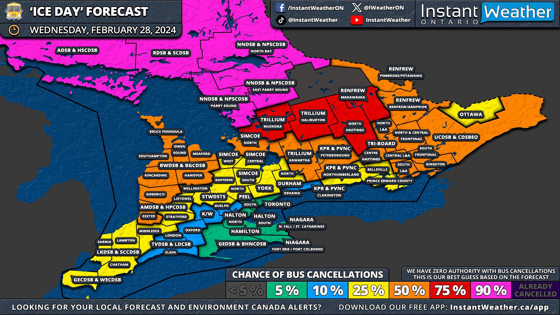
As the snow continues into the night, temperatures will further decline below the freezing point. This will cause any earlier rain and melted snow to freeze, resulting in icy road conditions by Thursday morning. Such conditions are likely to necessitate school bus cancellations across a broad area of Eastern Ontario.

Areas most prone to experiencing a ‘snow day’ on Thursday encompass rural school boards in the Ottawa Valley, spanning northern Tri-Board and extending into Northeastern Ontario, including North Bay and Sudbury. These regions are sitting at a 90% chance of school bus cancellations.

GOOGLE AD (NOT ENDORSED BY INSTANT WEATHER)

Surrounding areas, like the central parts of Tri-Board and Parry Sound, have a 75% chance of cancellations. Further south, the probability evens out for regions such as Peterborough, Kawartha Lakes, and Muskoka. Although it’s uncertain how much snow these areas will receive, the potential for icy road conditions might lead to cancellations.

For regions north and west of the GTA, including Simcoe and Dufferin County, there exists a minor possibility of school bus cancellations, though the likelihood remains low. The rest of Southern Ontario has a less than 10% chance of experiencing a snow day.


Disclaimer: Instant Weather has zero authority when it comes to bus and school closures. It is completely up to the school boards, bus companies, local authorities, and parents to decide what is best for their children. This is our best guess based on our forecast.


GOOGLE AD (NOT ENDORSED BY INSTANT WEATHER)

‘Snow Day’ Forecast: Snow Squalls Threaten to Cancel School Buses in Southern Ontario’s Snowbelt on Thursday

REGIONS NOT SHOWN ON THE MAP HAVE LESS THAN A 5% CHANCE OF BUS CANCELLATIONS


GOOGLE AD (NOT ENDORSED BY INSTANT WEATHER)

Intense snow squalls have developed east of Lake Huron and southeast of Georgian Bay as of Wednesday evening, resulting in significant snowfall accumulation and reduced visibility in the impacted areas. By Thursday afternoon, there is potential for up to 30cm of snow.

Given the expected substantial accumulation and limited visibility continuing into Thursday morning, school bus cancellations are likely.


GOOGLE AD (NOT ENDORSED BY INSTANT WEATHER)

The Northern Huron County and Kincardine region, where the worst conditions are anticipated, almost certainly will experience a snow day, with a 90% chance. Surrounding areas, including Perth, Wellington, Grey, Bruce, and Middlesex counties, face a probability of a snow day ranging from 50 to 75%.

Along the Georgian Bay shoreline, Simcoe County's West weather zone has the highest likelihood of a snow day with a 75% chance, while the Central and South weather zones have a 50% chance. Further inland, including London, Kitchener, and York Region, the likelihood of a snow day decreases to a range of 10 to 25%, but it cannot be entirely discounted.

The rest of Southern Ontario has a less than 10% chance of experiencing a snow day on Thursday.


Disclaimer: Instant Weather has zero authority when it comes to bus and school closures. It is completely up to the school boards, bus companies, local authorities, and parents to decide what is best for their children. This is our best guess based on our forecast.


GOOGLE AD (NOT ENDORSED BY INSTANT WEATHER)

‘Snow Day’ Forecast: Snow Squalls Likely to Cancel School Buses in Parts of Southern Ontario on Thursday

NOTE: YOU CAN CLICK ON THE MAP TO OPEN A ZOOMABLE IMAGE


GOOGLE AD (NOT ENDORSED BY INSTANT WEATHER)

Snow squalls have made a comeback to the familiar snowbelt areas around Lake Huron and Georgian Bay, and they're expected to continue throughout the night into Thursday. With conditions resembling a blizzard and up to 30cm of snow anticipated overnight, it is highly likely that many school boards in the impacted areas will declare a 'snow day' for Thursday.

The likelihood of a snow day is highest in all of Grey & Bruce counties, as well as the west and central weather zones of Simcoe County, with a 90% chance of school bus cancellations. For surrounding school boards and along the rest of the eastern Lake Huron shoreline, the chances vary from 50 to 75%.


GOOGLE AD (NOT ENDORSED BY INSTANT WEATHER)

Given that this event is highly localized to the snowbelt, widespread cancellations outside of the main affected region are not anticipated, as shown on our map. However, a few cancellations may occur in Eastern Ontario due to icy conditions remaining from this evening's flash freeze into the morning. These are more likely for the more rural school boards, for which we have assigned a 10% chance.

For the remainder of Southern Ontario, the likelihood of school bus cancellations for Thursday is very low.


Disclaimer: Instant Weather has zero authority when it comes to bus and school closures. It is completely up to the school boards, bus companies, local authorities, and parents to decide what is best for their children. This is our best guess based on our forecast.


GOOGLE AD (NOT ENDORSED BY INSTANT WEATHER)

‘Ice Day’ Forecast: Potential School Bus Cancellations on Wednesday in Southern Ontario Due to Expected Flash Freeze Risk

NOTE: YOU CAN CLICK ON THE MAP TO OPEN A ZOOMABLE IMAGE


GOOGLE AD (NOT ENDORSED BY INSTANT WEATHER)

After witnessing record-breaking temperatures and widespread thunderstorms on Tuesday, we're bracing for a drastic shift as Wednesday approaches. This shift will occur as a sharp decrease in temperatures beginning late Wednesday morning and lasting throughout the day.

Consequently, the rapid temperature drop—from double digits to below freezing in mere hours—will likely result in flash freeze conditions on the roads. Environment Canada has issued warnings regarding the flash freeze threat throughout Central and Eastern Ontario. Though the flash freeze is anticipated across all of Southern Ontario, the temperature decline will be more significant in areas under the warning.

Regarding school bus cancellations, the timing is particularly problematic as the temperature drop will not start until after the morning bus routes. This situation necessitates that school boards preemptively cancel afternoon bus services based on the forecast. Traditionally, they have relied on Environment Canada alerts for such decisions, and as of Tuesday evening, warnings have been issued only for Central and Eastern Ontario. The rest of Southern Ontario is under a special weather statement or no alert at all.


GOOGLE AD (NOT ENDORSED BY INSTANT WEATHER)

Central Ontario has the highest likelihood of school bus cancellations, coinciding with the warnings in effect and specifically citing Wednesday afternoon for the expected flash freeze. We've assigned these areas a 75 to 90% chance of an 'ice day,' confident that the warning will suffice to prompt bus cancellations.

For Eastern Ontario, where the warning indicates a flash freeze during the evening, it seems less probable that school boards will cancel buses. Here, the chances range from 25-50%; we can't dismiss the possibility entirely, but it appears to be unlikely.

Those in Southwestern Ontario will encounter the temperature dip earlier in the day, so we've estimated a 25 to 50% chance of an 'ice day' there since it will likely have a larger impact on the afternoon bus run. These odds could increase substantially if Environment Canada extends the flash freeze warning by the morning.

As for the Golden Horseshoe area, the decision by school boards to cancel buses is more uncertain; they typically require more extreme conditions, such as significant snowfall, for cancellations. Here, the probability of cancellations ranges from 5 to 10%.


Disclaimer: Instant Weather has zero authority when it comes to bus and school closures. It is completely up to the school boards, bus companies, local authorities, and parents to decide what is best for their children. This is our best guess based on our forecast.


GOOGLE AD (NOT ENDORSED BY INSTANT WEATHER)

‘Snow Day’ Forecast: Heavy Snow Could Lead to School Bus Cancellations on Friday in Parts of Southern Ontario

REGIONS NOT SHOWN ON THE MAP HAVE LESS THAN A 5% CHANCE OF BUS CANCELLATIONS


GOOGLE AD (NOT ENDORSED BY INSTANT WEATHER)

The first widespread snowfall of the month has blanketed Southern Ontario with over 5 to 10cm of snow during Thursday afternoon. Although the snow has subsided in most areas, it continues to impact Eastern Ontario tonight, coupled with the resurgence of lake effect snow off Lake Huron.

These conditions are expected to lead to challenging road conditions throughout parts of Central and Eastern Ontario, particularly in rural regions, and may result in school bus cancellations on Friday morning. However, such cancellations are likely to be very isolated, with most students still attending school—so temper your expectations for a snow day!

The Grey-Bruce region, including Southampton and Kincardine, stands the highest chance of experiencing a snow day, with a 75% probability. Overnight snow squall activity is anticipated to persist into Friday morning, accompanied by strong wind gusts that will significantly reduce visibility on roads. Given the snow squall warning issued by Environment Canada, we anticipate school bus cancellations in this area.


GOOGLE AD (NOT ENDORSED BY INSTANT WEATHER)

Nearby areas such as Goderich, Listowel, Hanover, Owen Sound, Meaford, and the Bruce Peninsula have a 25 to 50% chance of declaring a 'snow day' on Friday. These areas are also expected to feel the effects of the lake effect snow, although there is less certainty regarding its exact impact and whether it will meet the criteria for cancellations.

In Eastern Ontario, the snow is set to continue this evening and overnight but will lighten as the night progresses. With an additional 5-10cm of snow anticipated, this could potentially result in school bus cancellations on Friday morning, especially among the more rural school boards like Renfrew and Tri-board, where the chances range from 25 to 50%.

For the remainder of Central and Eastern Ontario, the likelihood of school bus cancellations is low to very low. Although significant additional snowfall is not expected, the slushy roads might prompt a few school boards to cancel, depending on local conditions which are difficult to forecast accurately.

School bus cancellations are not anticipated around the Golden Horseshoe and in Deep Southwestern Ontario, with a less than 5% chance of a 'snow day'.


Disclaimer: Instant Weather has zero authority when it comes to bus and school closures. It is completely up to the school boards, bus companies, local authorities, and parents to decide what is best for their children. This is our best guess based on our forecast.


GOOGLE AD (NOT ENDORSED BY INSTANT WEATHER)

‘Snow Day’ Forecast: Questionable Chance for School Bus Cancellations on Thursday in Southern Ontario

NOTE: YOU CAN CLICK ON THE MAP TO OPEN A ZOOMABLE IMAGE


GOOGLE AD (NOT ENDORSED BY INSTANT WEATHER)

With Southern Ontario bracing for its first widespread snowfall event of the month, many might anticipate the return of school bus cancellations across various parts of the region. Unfortunately, for those hoping for a 'snow day' due to this system, the timing of the snowfall may dampen such expectations.

Snow is forecasted to start around late Thursday morning or early afternoon, with heavier snowfall intensifying across our region throughout the afternoon. This is expected to significantly affect the afternoon bus service.

The pivotal question remains whether school boards will preemptively cancel morning school buses based on the forecast. Currently, Environment Canada has issued weather advisories, which may not be sufficient for most school boards to consider bus cancellations. However, there is a mention of the potential for these advisories to be upgraded to snowfall warnings. Should this upgrade occur by morning, it would substantially increase the likelihood of cancellations in the affected areas.


GOOGLE AD (NOT ENDORSED BY INSTANT WEATHER)

This forecast primarily concerns school boards known for their proactive approach to bus cancellations, including Parry Sound, Bruce Peninsula, Muskoka, Haliburton, and Tri-board. We have given these regions a 25 to 50% chance of experiencing a snow day, coinciding with some of the highest anticipated snowfall totals.

Beyond these areas, the chance of a snow day drops to 5 to 10% across the rest of Central and Eastern Ontario, extending into Southwestern Ontario. While cancellations across these school boards seem unlikely, it cannot be entirely dismissed that a few might decide to cancel based on the forecast.

For the Golden Horseshoe, including urban school boards in the Greater Toronto & Hamilton Area, the expectation of cancellations is minimal, with predicted total snowfall accumulation between 5-10cm. Consequently, we have estimated a less than 5% chance of a snow day for these regions.


Disclaimer: Instant Weather has zero authority when it comes to bus and school closures. It is completely up to the school boards, bus companies, local authorities, and parents to decide what is best for their children. This is our best guess based on our forecast.


GOOGLE AD (NOT ENDORSED BY INSTANT WEATHER)

‘Ice Day’ Forecast: Freezing Rain Likely to Cancel School Buses Across Eastern Ontario for Another Day on Friday

NOTE: YOU CAN CLICK ON THE MAP TO OPEN A ZOOMABLE IMAGE


GOOGLE AD (NOT ENDORSED BY INSTANT WEATHER)

On Friday morning, Eastern Ontario faces yet another risk of freezing rain, prompting Environment Canada to issue freezing rain warnings. Given these warnings and the anticipated hazardous driving conditions during the school day, it is likely that many school boards will cancel buses for yet another day.

For some school boards, this could be the second or even third consecutive ‘ice day’. Meanwhile, the current fog over Southwestern Ontario and parts of the Golden Horseshoe is expected to clear up by morning, making another ‘fog day’ unlikely.


GOOGLE AD (NOT ENDORSED BY INSTANT WEATHER)

School boards with the highest chance of bus cancellations include those in Ottawa, Upper Canada, Renfrew, and the northern regions of the Tri-Board. These areas face a 90% chance of an ‘ice day’ on Friday.

In the southern part of the Tri-Board, covering Kingston and Belleville, cancellations are still considered likely, though with less certainty, due to the area being under a special weather statement rather than a freezing rain warning.

For those in Peterborough and Haliburton, the probability of an ‘ice day’ ranges from 50 to 75%. The rest of Central Ontario has a 10 to 25% chance, as icy conditions are possible, but it remains questionable whether they will be severe enough to warrant bus cancellations. The likelihood of an ‘ice day’ in the rest of Southern Ontario is less than 10%.


Disclaimer: Instant Weather has zero authority when it comes to bus and school closures. It is completely up to the school boards, bus companies, local authorities, and parents to decide what is best for their children. This is our best guess based on our forecast.


GOOGLE AD (NOT ENDORSED BY INSTANT WEATHER)

‘Ice/Fog Day’ Forecast: Significant Freezing Rain Almost Certain to Cancel School Buses on Thursday in Eastern Ontario

NOTE: YOU CAN CLICK ON THE MAP TO OPEN A ZOOMABLE IMAGE


GOOGLE AD (NOT ENDORSED BY INSTANT WEATHER)

As of Wednesday evening, Eastern Ontario is experiencing ongoing prolonged freezing rain, expected to continue throughout the night. Although the freezing rain will lessen after midnight, it will significantly affect road conditions by morning. Consequently, there is a high likelihood of school bus cancellations in many regions on Thursday.

Additionally, foggy conditions are affecting Southwestern Ontario and parts of the Golden Horseshoe. The fog is anticipated to thicken overnight and linger into the morning, potentially leading to localized bus cancellations in rural areas around London and east of Lake Huron.


GOOGLE AD (NOT ENDORSED BY INSTANT WEATHER)

NOTE: YOU CAN CLICK ON THE MAP TO OPEN A ZOOMABLE IMAGE

The greatest chance of an ‘ice day’ is in much of Eastern Ontario, excluding Ottawa. Rural school boards in this area have a 90% chance of school bus cancellations, while the City of Ottawa has a 75% chance, as this school board is typically more stringent with cancellations. We don’t expect the conditions to be safe for bus operations, but some school boards, particularly in urban areas with less reliance on buses, might decide differently.

In parts of Central Ontario, including Muskoka, Haliburton, Kawartha Lake, Peterborough, northern Durham, and northern Simcoe County, the probability of an ‘ice day’ remains fairly strong. Chances range from 25% in the more western and southern areas to 75% in Peterborough and Haliburton.

These lower chances are due to the expected less intense freezing rain and ending earlier in the night, potentially allowing roads to be cleared in time for the morning bus run. However, this will heavily depend on local road conditions, and the actual probability could be higher, though we don’t have enough confidence to increase these estimates.

In Southwestern Ontario, there is a low chance of a ‘fog day’ in areas around London, including Middlesex, Oxford, and Elgin counties, which experienced cancellations on Wednesday. The surrounding regions have a 5% chance, as cancellations can't be entirely ruled out, but most school boards are expected to operate as usual.


Disclaimer: Instant Weather has zero authority when it comes to bus and school closures. It is completely up to the school boards, bus companies, local authorities, and parents to decide what is best for their children. This is our best guess based on our forecast.


GOOGLE AD (NOT ENDORSED BY INSTANT WEATHER)

‘Ice Day’ Forecast: Questionable Chance of School Bus Cancellations on Wednesday in Parts of Southern Ontario

NOTE: YOU CAN CLICK ON THE MAP TO OPEN A ZOOMABLE IMAGE


GOOGLE AD (NOT ENDORSED BY INSTANT WEATHER)

Freezing rain is currently affecting parts of Southwestern Ontario and the northern fringes of the Greater Toronto Area, and it's expected to persist past midnight. Although the freezing rain is likely to stop well before the morning school bus schedule, it could still result in icy conditions. Consequently, there's a small possibility of an ‘ice day’.

In Eastern Ontario, freezing rain is anticipated on Wednesday afternoon. The majority of this activity is expected in the late afternoon, so school bus operations on Wednesday should not be significantly impacted. However, Environment Canada might issue alerts by morning, which could lead some weather-sensitive school boards to proactively cancel buses.


GOOGLE AD (NOT ENDORSED BY INSTANT WEATHER)

For the broader swath of Southwestern Ontario extending into the For the area around the Dundalk Highlands, including Orangeville and Wellington County, there's a 25% chance of school bus cancellations due to potentially heavy freezing rain. Moving east, the Tri-Board regions around Belleville and Kingston also have a 25% chance of cancellations. Here, freezing rain could start in the early afternoon, and this school board is more inclined to cancel buses under such conditions.

Surrounding school boards on the outskirts of the Golden Horseshoe and into Eastern Ontario face a 5-10% chance of an ‘ice day’. While it’s fairly unlikely, we cannot completely discount the possibility of a few school boards cancelling buses based on local road conditions.


Disclaimer: Instant Weather has zero authority when it comes to bus and school closures. It is completely up to the school boards, bus companies, local authorities, and parents to decide what is best for their children. This is our best guess based on our forecast.


GOOGLE AD (NOT ENDORSED BY INSTANT WEATHER)

‘Ice Day’ Forecast: Freezing Rain Risk Likely to Cancel School Buses on Tuesday in Parts of Southwestern Ontario

CENTRAL & EASTERN ONTARIO HAVE LESS THAN A 5% CHANCE OF BUS CANCELLATIONS


GOOGLE AD (NOT ENDORSED BY INSTANT WEATHER)

A mix of messy precipitation is set to sweep into Southwestern Ontario overnight, with a freezing rain warning already in effect for Windsor and Chatham. This is expected to lead to icy road conditions, which will persist throughout Tuesday morning. Consequently, school bus cancellations are highly likely in the most severely affected areas.

The Windsor area is particularly at risk, with several hours of freezing rain forecasted overnight into Tuesday morning. The likelihood of an ‘ice day’ in this region stands at a high 90%. Meanwhile, the Chatham region faces a 75% chance of school bus cancellations.

As we move northeast, the probability of school bus cancellations diminishes slightly due to the later onset of precipitation. The Sarnia, Lambton, Middlesex, and Elgin regions have a 50% chance of cancellations. The City of London and nearby areas like Exeter, Stratford, and Oxford face a lower chance, at about 25%.


GOOGLE AD (NOT ENDORSED BY INSTANT WEATHER)

For the broader swath of Southwestern Ontario extending into the Greater Toronto Area, the likelihood of school bus cancellations is relatively low, ranging from 5 to 10%. While conditions may not be severe enough for most school boards to cancel buses, we cannot completely dismiss the possibility of one or two boards proactively cancelling in anticipation of the afternoon snowfall.

Central and Eastern Ontario are not expected to be impacted until later on Tuesday, so no cancellations are anticipated in these regions. As a result, our forecast map does not highlight these areas, given that the probability of cancellations there is below 5%.


Disclaimer: Instant Weather has zero authority when it comes to bus and school closures. It is completely up to the school boards, bus companies, local authorities, and parents to decide what is best for their children. This is our best guess based on our forecast.


GOOGLE AD (NOT ENDORSED BY INSTANT WEATHER)

‘Snow Day’ Forecast: Yet Another Likely Snow Day for Kids in the Parry Sound and Muskoka Region on Thursday

NOTE: YOU CAN CLICK ON THE MAP TO OPEN A ZOOMABLE IMAGE


GOOGLE AD (NOT ENDORSED BY INSTANT WEATHER)

The snow squalls show no sign of stopping as they continue to blanket areas east of Georgian Bay with what seems like an unrelenting onslaught of snow over the past several days. This persistent threat of snow squalls is set to carry on through the night and into Thursday, which will likely result in school bus cancellations in the hardest-hit areas.

Lake effect snow to the east of Lake Huron has been affecting Grey, Bruce, Huron, and Perth counties throughout the day. This activity is expected to subside somewhat overnight, which implies that the likelihood of a snow day remains high, although not as certain, given that conditions in the morning are expected to improve compared to the recent past.

In the Fort Erie and Picton regions, there have been sporadic heavy snowfalls due to lake effect snow from Lakes Ontario and Erie. While this is predicted to lessen overnight, there remains a slight possibility of school bus cancellations for Thursday.


GOOGLE AD (NOT ENDORSED BY INSTANT WEATHER)

Areas with the highest likelihood of a snow day on Thursday are Muskoka and Parry Sound, standing at a 90% chance of school bus cancellations. If our forecast holds, this would mark the fourth snow day for Parry Sound and the third for Muskoka this week.

Residents of the Bruce Peninsula face a 75% chance of school bus cancellations, while the odds range between 25-50% for the rest of the Grey and Bruce counties, as well as Manitoulin Island. There is also a slight chance (25%) of cancellations in Goderich, northern Simcoe, Haliburton, North Bay, and Prince Edward County.

For the remainder of Southern Ontario, which has not been significantly affected by lake effect snow, the probability of school bus cancellations is below 10%.


Disclaimer: Instant Weather has zero authority when it comes to bus and school closures. It is completely up to the school boards, bus companies, local authorities, and parents to decide what is best for their children. This is our best guess based on our forecast.


GOOGLE AD (NOT ENDORSED BY INSTANT WEATHER)

‘Snow Day’ Forecast: Some Parts of Southern Ontario Could See Their Third Day in a Row With School Buses Cancelled

NOTE: YOU CAN CLICK ON THE MAP TO OPEN A ZOOMABLE IMAGE


GOOGLE AD (NOT ENDORSED BY INSTANT WEATHER)

As the snow squall outbreak persists in the snowbelt region east of Georgian Bay, it looks set to cause a third consecutive day of bus cancellations in the Parry Sound and North Bay regions. Our forecast for Wednesday closely resembles that of Tuesday, as there has been little change in the squalls' locations.

Additionally, lake effect snow from Lake Ontario and Lake Erie may result in quick snow accumulation and challenging travel conditions in Prince Edward County and the Southern Niagara Region. However, we have less confidence in this forecast since the heaviest squalls are expected to remain south of the Canadian border.


GOOGLE AD (NOT ENDORSED BY INSTANT WEATHER)

Areas most likely to see a snow day on Wednesday include the Bruce Peninsula, Parry Sound, and North Bay, with a 90% chance of school bus cancellations. Having already experienced cancellations on Monday and Tuesday, these regions may face a third, and potentially a fourth day off, as Thursday is also shaping up to be problematic.

Muskoka's chances have been increased to 75%, as snow squalls are forecasted to hit the northern parts of the region, including Huntsville, which could lead to cancellations for the entire region. Prince Edward County faces a similar situation, with Lake Ontario squalls impacting the Picton area.

The Owen Sound, Southampton, and Meaford areas have a 50% chance of experiencing a snow day. There's a slight chance (25%) for cancellations in Kincardine, Hanover, and the southern part of the Niagara region.

The rest of Southern Ontario, not significantly impacted by lake effect snow, has less than a 10% chance of school bus cancellations.


Disclaimer: Instant Weather has zero authority when it comes to bus and school closures. It is completely up to the school boards, bus companies, local authorities, and parents to decide what is best for their children. This is our best guess based on our forecast.


GOOGLE AD (NOT ENDORSED BY INSTANT WEATHER)

‘Snow Day’ Forecast: Localized School Bus Cancellations Possible for Tuesday in Parts of Ontario as Snow Squalls Continue

NOTE: YOU CAN CLICK ON THE MAP TO OPEN A ZOOMABLE IMAGE


GOOGLE AD (NOT ENDORSED BY INSTANT WEATHER)

Intense but localized snow squalls continue to severely affect the Bruce Peninsula, Parry Sound, and North Bay regions, leading to significant snowfall accumulation. This situation is expected to persist throughout the night and into Tuesday.

In addition, lake effect snow from Lake Ontario and Lake Erie could lead to rapid snow accumulation and difficult travel conditions in Prince Edward County and the Southern Niagara Region.

Given that the snow squalls show no signs of easing up, school bus cancellations are almost certain in the hardest-hit regions on Tuesday.


GOOGLE AD (NOT ENDORSED BY INSTANT WEATHER)

Regions that are most likely to experience a snow day on Tuesday, including Bruce Peninsula, Parry Sound, North Bay, and Prince Edward County, also had cancellations on Monday. This situation could result in an extended four-day weekend for students in these areas, with a 90% chance of school bus cancellations on Tuesday.

Manitoulin Island has a 75% chance of a snow day, while Sudbury has a lower likelihood, at 25%, as it is in a separate cancellation zone. Meanwhile, the rest of the Grey-Bruce counties, Muskoka, Napanee, and Southern Niagara have a 25-50% chance of experiencing a snow day on Tuesday.

The rest of Southern Ontario, not significantly affected by the lake effect snow, has less than a 10% chance of seeing school bus cancellations.


Disclaimer: Instant Weather has zero authority when it comes to bus and school closures. It is completely up to the school boards, bus companies, local authorities, and parents to decide what is best for their children. This is our best guess based on our forecast.


GOOGLE AD (NOT ENDORSED BY INSTANT WEATHER)

‘Snow Day’ Forecast: Snow Squalls Likely to Cancel School Buses on Monday in Parts of Central & Southwestern Ontario

NOTE: YOU CAN CLICK ON THE MAP TO OPEN A ZOOMABLE IMAGE


GOOGLE AD (NOT ENDORSED BY INSTANT WEATHER)

Snow squalls continue to batter regions in the typical snowbelt around Lake Huron and Georgian Bay, persisting through Sunday. This activity has resulted in impressive snowfall totals, reaching up to 40cm in Grey, Bruce, and Simcoe counties.

With the lake effect snow machine still going strong and showing no signs of abating over the next 24 hours, it's likely that several school bus cancellations will occur on Monday due to the poor road conditions.

During the day, the focus of the activity has been to the south, but these squalls have begun moving north toward the Bruce Peninsula, Muskoka, and Parry Sound regions. This shift implies that areas heavily impacted today might have experienced the brunt of it, as squalls are expected to remain north for most of Monday.

This change in wind direction could also bring the Lake Ontario and Erie squalls across the border, potentially impacting the Niagara, Picton, and Kingston regions on Monday morning. Consequently, bus cancellations in these regions cannot be ruled out.


GOOGLE AD (NOT ENDORSED BY INSTANT WEATHER)

While the heaviest snow has occurred around the Barrie, Midland, Orillia, and Grey-Bruce regions, additional significant snowfall overnight is not expected. Therefore, the likelihood of a snow day might seem lower than what the current conditions suggest.

We anticipate that there will be enough time for road crews to clear the roads in some of these areas. Hence, the focus of this forecast is on additional snow accumulating overnight into Monday morning.

Bruce County and regions directly east and northeast of Georgian Bay, including Muskoka, Parry Sound, North Bay, the Bruce Peninsula, and Southampton, will experience the worst conditions. There's a very high chance, about 90%, of a snow day in these regions, as rapid snow accumulation will likely render it nearly impossible for school buses to operate safely.

A snow day is also probable for Kincardine, Owen Sound, Meaford, and the northern zone of Simcoe County, with a 75% chance of school bus cancellations. This prediction is less certain since the squalls might not be active at the time, but the overnight accumulations should be sufficient to justify cancellations.

The situation is more uncertain for the rest of Simcoe County, Haliburton, Kawartha Lakes, and parts of Huron, Perth, and Dufferin counties, where a snow day is possible but only has a 50-50 chance at best.

The Prince Edward County, Belleville, and Kingston region, affected by the Lake Ontario squall, also have a 50% chance of a snow day. In the Niagara region, the likelihood is around 25%, but there's a higher chance of localized delays, especially closer to the Lake Erie shoreline where the squall activity will be most intense.

In other parts of Southern Ontario, a snow day is unlikely, as the heaviest snow will be concentrated in areas around the lakes.


Disclaimer: Instant Weather has zero authority when it comes to bus and school closures. It is completely up to the school boards, bus companies, local authorities, and parents to decide what is best for their children. This is our best guess based on our forecast.


GOOGLE AD (NOT ENDORSED BY INSTANT WEATHER)

‘Winter Storm Day’ Forecast: Second Day of School Bus Cancellations Possible in Parts of Southern Ontario on Wednesday

NOTE: YOU CAN CLICK ON THE MAP TO OPEN A ZOOMABLE IMAGE


GOOGLE AD (NOT ENDORSED BY INSTANT WEATHER)

The winter storm impacting Southern Ontario on Tuesday is set to persist into Tuesday night and early Wednesday morning. In most areas, the transition to rain has already happened or is expected shortly.

However, the forecast is different in the northern regions, including the Ottawa Valley and northern parts of Central Ontario. These areas are expected to continue seeing heavy snowfall tonight and into the early overnight hours.

Snowfall accumulations are expected to range from 15-25cm, with Sudbury and North Bay possibly receiving up to 30cm. A changeover to rain in some of these areas is anticipated just after midnight.

Given the projected snowfall amounts and their timing, it's highly probable that school buses will be cancelled across a broad region of Eastern and Central Ontario on Wednesday. This would mark the second consecutive 'snow day' for some students, as many areas already experienced cancellations on Tuesday due to the approaching storm.


GOOGLE AD (NOT ENDORSED BY INSTANT WEATHER)

In Eastern Ontario's rural school districts, including Pembroke, Renfrew, and Bancroft, there is a 90% chance of a 'snow day.' Similarly, Parry Sound, North Bay, and Sudbury also face a 90% likelihood of school cancellations.

The Ottawa school board area has a 75% chance of a 'snow day,' with a slightly lower probability reflecting uncertainty over whether the morning road conditions in urban areas will meet the threshold for bus cancellations. The Haliburton and Smiths Falls areas also have a 75% chance, as the transition to rain is expected to occur earlier, thereby limiting snowfall totals.

Chances of school bus cancellations diminish moving southwestward, where snow is expected to have already turned to rain by the evening. This leaves enough time for road crews to clear the streets. Areas like Muskoka, Northern Simcoe County, Kawartha Lakes, Peterborough, and the Belleville/Kingston region have a slight to equal chance (25-50%) of a 'snow day.'

For the rest of Southern Ontario, the likelihood of experiencing a 'snow day' on Wednesday is very low, with a maximum probability of 5-10%.


Disclaimer: Instant Weather has zero authority when it comes to bus and school closures. It is completely up to the school boards, bus companies, local authorities, and parents to decide what is best for their children. This is our best guess based on our forecast.


GOOGLE AD (NOT ENDORSED BY INSTANT WEATHER)

‘Winter Storm Day’ Forecast: Looming Winter Storm Threat Could Cancel School Buses in Parts of Southern Ontario on Tuesday

NOTE: YOU CAN CLICK ON THE MAP TO OPEN A ZOOMABLE IMAGE


GOOGLE AD (NOT ENDORSED BY INSTANT WEATHER)

A winter storm is on the horizon for Southern Ontario, anticipated to bring a diverse mix of precipitation starting Tuesday morning. This system is set to deliver significant snowfall in some regions, while others will experience a combination of snow, ice pellets, freezing rain, and rain. Consequently, Environment Canada has issued various weather alerts, including winter storm warnings, snowfall warnings, and special weather statements.

The impending storm is likely to lead to poor road conditions, raising the possibility of school bus cancellations on Tuesday. However, the timing of the storm complicates matters. The most severe conditions are expected to begin Tuesday afternoon and persist into early Wednesday. Morning conditions are not anticipated to be overly severe in most areas, but they are expected to deteriorate as the day progresses.

As a result, school boards and bus companies would need to proactively cancel bus services on Tuesday to avoid the hazardous travel conditions anticipated for the afternoon commute. Historically, the decision to proactively cancel buses has varied among school boards. The forecast heavily relies on boards with a history of proactive cancellations which are more likely to do so again, compared to those that are less inclined to cancel.


GOOGLE AD (NOT ENDORSED BY INSTANT WEATHER)

The areas of Parry Sound, North Bay, Bancroft, and Pembroke face the highest likelihood of a snow day, with bus cancellation probabilities ranging from 75 to 90%. Given the strong warning from Environment Canada and the tendency of these school boards to cancel buses based on weather warnings, a snow day in these regions seems highly probable.

For the rest of Eastern and Central Ontario, the situation is less clear and largely dependent on individual school board decisions. The Ottawa school board, being more urban, typically requires more severe conditions to cancel buses, especially given that the Environment Canada warning states the worst conditions start late on Tuesday.

Further south, the north and west areas of the Greater Toronto Area have about a 25% chance of school bus cancellations. In contrast, the more urban school boards in the Golden Horseshoe region are less likely to cancel buses as the expected impact of the storm is relatively lower.

In Deep Southwestern Ontario and the Niagara region, the probability of a snow day is approximately 5%. While snow is expected during the morning hours, it may not be sufficient to warrant cancellations.

Looking ahead to Wednesday, there's an increased likelihood of widespread snow day potential throughout Central and Eastern Ontario.


Disclaimer: Instant Weather has zero authority when it comes to bus and school closures. It is completely up to the school boards, bus companies, local authorities, and parents to decide what is best for their children. This is our best guess based on our forecast.


GOOGLE AD (NOT ENDORSED BY INSTANT WEATHER)

‘Snow Day’ Forecast: Widespread Snowfall Could Lead to School Bus Cancellations in Parts of Southern Ontario on Tuesday

NOTE: YOU CAN CLICK ON THE MAP TO OPEN A ZOOMABLE IMAGE


GOOGLE AD (NOT ENDORSED BY INSTANT WEATHER)

Heavy snowfall is anticipated to blanket Southern Ontario from Monday evening into Tuesday, leading Environment Canada to issue several weather alerts, including winter travel advisories and snow squall warnings.

By Tuesday morning, snow accumulations are expected to vary widely, with 5 to 10cm forecasted in general. However, areas along the southern shores of Lake Huron and Georgian Bay might see 10 to 20cm due to lake-effect snow and squalls developing tonight.

Although the expected snowfall totals are usually not significant enough to cause school bus cancellations, strong wind gusts accompanying the snow are a concern. These winds are likely to cause blowing snow and reduced visibility, with the most severe conditions predicted for early Tuesday morning, coinciding with the time for deciding on school bus cancellations.


GOOGLE AD (NOT ENDORSED BY INSTANT WEATHER)

The area south of Georgian Bay, including Meaford and Collingwood regions, stands a 90% chance of experiencing a ‘snow day’ due to the likelihood of the highest snowfall totals. In contrast, Central Ontario and regions along the Lake Huron shoreline have a 50-75% chance of a snow day.

The variability in snowfall impacts across regions makes predicting school bus cancellations challenging. Specifically, the Barrie and Owen Sound area, under a snow squall warning for 10-20cm of snow, has a 75% chance of cancellations.

The Bancroft and Barry’s Bay region also has a strong possibility (75%) of a snow day. The latest models suggest they might receive slightly higher snowfall (up to 15cm) compared to nearby areas. The local school boards are also known to be particularly sensitive to weather conditions.

Further away from the lakes, the likelihood of a snow day diminishes, especially in urban areas like the GTA. Although widespread cancellations are unlikely, localized cancellations due to road conditions cannot be completely discounted.

There remains a chance, albeit small, that this snowfall event could exceed expectations, leading to more widespread cancellations. As a result, every region has at least a 5% chance of experiencing a snow day on Tuesday.


Disclaimer: Instant Weather has zero authority when it comes to bus and school closures. It is completely up to the school boards, bus companies, local authorities, and parents to decide what is best for their children. This is our best guess based on our forecast.


GOOGLE AD (NOT ENDORSED BY INSTANT WEATHER)

‘Snow Day’ Forecast: Central Ontario Likely to See School Bus Cancellations on Wednesday Due to Snow Squalls

NOTE: YOU CAN CLICK ON THE MAP TO OPEN A ZOOMABLE IMAGE


GOOGLE AD (NOT ENDORSED BY INSTANT WEATHER)

Snow squalls have developed off Georgian Bay as of Tuesday evening and are expected to persist overnight into Wednesday. Environment Canada has issued snow squall watches and warnings for the impacted areas, forecasting up to 10-25cm of snow accumulation by Wednesday.

The alerts from Environment Canada, coupled with the anticipated challenging driving conditions on Wednesday, strongly suggest that school buses will be cancelled in the Muskoka and Parry Sound regions. Consequently, we've assigned a 90% likelihood of a 'snow day' in these areas for Wednesday. For those in Simcoe County's 'north' weather zone and the Bruce Peninsula, the probability of school bus cancellations stands at 75%.


GOOGLE AD (NOT ENDORSED BY INSTANT WEATHER)

Moving south and east, the chances of school bus cancellations become less predictable, as they hinge on individual school board responses to Environment Canada's alerts. Lake effect snow is expected to move southward towards Barrie by late morning, but since bus cancellation decisions are made earlier, school boards will need to proactively cancel school buses, anticipating deteriorating conditions later in the day.

Haliburton, Kawartha Lakes, Simcoe County (West), and parts of Grey-Bruce face a 50% chance of experiencing a snow day. Meanwhile, the City of Barrie and the remainder of Grey-Bruce have a 25% likelihood of a snow day. The rest of Southern Ontario is unlikely to experience bus cancellations, as the event is expected to remain confined to the traditional snowbelt areas.


Disclaimer: Instant Weather has zero authority when it comes to bus and school closures. It is completely up to the school boards, bus companies, local authorities, and parents to decide what is best for their children. This is our best guess based on our forecast.


GOOGLE AD (NOT ENDORSED BY INSTANT WEATHER)

‘Snow/Ice Day’ Forecast: School Bus Cancellations Almost Certain on Monday in Eastern Ontario Due to Ongoing Winter Storm

NOTE: YOU CAN CLICK ON THE MAP TO OPEN A ZOOMABLE IMAGE


GOOGLE AD (NOT ENDORSED BY INSTANT WEATHER)

A winter storm is currently impacting a significant portion of Eastern and Central Ontario, and its effects are anticipated to persist into the overnight hours and early Monday morning. The storm is causing poor driving conditions, characterized by freezing rain throughout Sunday that is expected to transition into heavy snow later in the evening.

In response to these conditions, Environment Canada has issued a winter storm warning for specific areas in the Ottawa Valley, strongly advising against non-essential travel until conditions improve on Monday. Given the severity of the warning and the anticipated poor road conditions, it is highly likely that school bus cancellations will occur in Eastern Ontario.


GOOGLE AD (NOT ENDORSED BY INSTANT WEATHER)

The rural school boards surrounding the Ottawa region have a 90% likelihood of experiencing a 'snow/ice day' on Monday. Although Ottawa is expected to be similarly affected, the local school board tends to adhere to a more strict policy for cancelling school buses due to the generally better-maintained urban roads. We are forecasting a 75% chance for Ottawa, as we believe the conditions will still be severe enough to warrant cancellations.

Beyond Eastern Ontario, we do not anticipate widespread cancellations, as freezing rain in some areas is forecasted to come to an end by this evening, transitioning to wet snow with less than 10cm of accumulation possible.

Those in the Haliburton, Muskoka, and East Parry Sound regions have a 25% chance of experiencing a snow day. The likelihood decreases to 5-10% for the rest of Central Ontario, including Peterborough, Simcoe County, and areas northwest of the GTA.


Disclaimer: Instant Weather has zero authority when it comes to bus and school closures. It is completely up to the school boards, bus companies, local authorities, and parents to decide what is best for their children. This is our best guess based on our forecast.


GOOGLE AD (NOT ENDORSED BY INSTANT WEATHER)

‘Snow Day’ Forecast: Continued Snow Squall Risk Brings Third Day of Possible School Bus Cancellations on Wednesday in Parts of Central Ontario

NOTE: YOU CAN CLICK ON THE MAP TO OPEN A ZOOMABLE IMAGE


GOOGLE AD (NOT ENDORSED BY INSTANT WEATHER)

Snow squalls are expected to return to regions east of Georgian Bay and Grey-Bruce overnight and Wednesday morning. These bands of snow will bring reduced visibility leading to poor road conditions throughout the Parry Sound and Muskoka regions.

School bus cancellations are very likely on Wednesday with a 75% chance for Parry Sound and Muskoka. We considered going with a 90% chance, but it’s uncertain how strong the activity will be during the morning hours.


GOOGLE AD (NOT ENDORSED BY INSTANT WEATHER)

There is a 50% chance for Northern Simcoe County along with the Bruce Peninsula which may also be affected by the lake effect snow at times tomorrow.

Away from those particular regions, the chance of a snow day is fairly limited with 25% or less of a chance for the rest of Grey-Bruce and areas around Lake Simcoe. We don’t expect any bus cancellations in Deep Southwestern Ontario or around the Golden Horseshoe as this will be contained to the snowbelt around Lake Huron and Georgian Bay.


Disclaimer: Instant Weather has zero authority when it comes to bus and school closures. It is completely up to the school boards, bus companies, local authorities, and parents to decide what is best for their children. This is our best guess based on our forecast.


GOOGLE AD (NOT ENDORSED BY INSTANT WEATHER)