Flash Freeze Threatens Wednesday Afternoon/Evening Commute Across Southern Ontario

NOTE: YOU CAN CLICK ON THE MAP TO OPEN A ZOOMABLE IMAGE

After experiencing a series of thunderstorms and Ontario's first 20°C temperature of the season recorded in Windsor on Tuesday, we're on the brink of a significant shift as we head into Wednesday. It feels like we're at the peak of a roller coaster, about to dive back down into winter-like temperatures.

This transition will be marked by a sharp cold front, leading to a rapid decrease in temperatures. Expect to see temperatures plummet from the upper single digits or low teens to well below the freezing mark within just a few hours on Wednesday. With roads and surfaces still wet from previous rainfall, a 'flash freeze' is almost certain, where all moisture on surfaces will quickly freeze, turning to ice.


GOOGLE AD (NOT ENDORSED BY INSTANT WEATHER)

The severity of the flash freeze will differ across regions, with Central and Eastern Ontario witnessing the most dramatic temperature drops — from near double digits to the freezing mark within an hour or two in the afternoon to early evening. In Southwestern Ontario and the Golden Horseshoe, the temperature will initially drop to just above freezing, with a more gradual descent toward the freezing mark. This difference in temperature change rate will significantly impact the flash freeze threat, with a slower onset for these areas.

Following the cold front, lake effect snow will begin to form around Lake Huron and Georgian Bay from Wednesday evening into Thursday. While specifics will be detailed in a separate forecast, it's likely that traditional snowbelt regions could see upwards of 20-30cm of snow by week's end. However, this snow won't linger, as milder air is forecasted to return by the weekend.

NOTE: YOU CAN CLICK ON THE MAP TO OPEN A ZOOMABLE IMAGE

Wednesday morning will greet you with temperatures well above seasonal, in the mid to upper single digits through Central and Eastern Ontario, and possibly even double digits in the southwest. This warmth is extraordinary for this time of the year, especially considering it will occur in the morning, typically cooler than peak daytime temperatures. Windsor, Chatham, and Sarnia could see temperatures ranging from 12 to 15°C, making them the expected hotspots.

The onset of change will start later in the morning as the cold front approaches. Much of Southern Ontario will still experience mild temperatures of 6 to 9°C, except along the Lake Huron shoreline, where temperatures will be closer to 3°C, and near-freezing on the Bruce Peninsula.


GOOGLE AD (NOT ENDORSED BY INSTANT WEATHER)

NOTE: YOU CAN CLICK ON THE MAP TO OPEN A ZOOMABLE IMAGE

Northeastern Ontario will display the stark contrast in temperature gradients. North Bay and Sudbury will enjoy continued warmth from the south, with temperatures of 2 to 6°C, while Elliot Lake and areas towards Temiskaming Shores will be among the first to experience the cold plunge raging from -3 to -12°C.

NOTE: YOU CAN CLICK ON THE MAP TO OPEN A ZOOMABLE IMAGE

By early afternoon on Wednesday, the cold air will start to dominate, pushing the warm air east and causing temperatures to drop below freezing across much of Southwestern and Central Ontario. The Grey-Bruce region will see temperatures between -3°C to -5°C by 1 PM. The freezing line will sweep across Central Ontario and the Golden Horseshoe early in the afternoon.


GOOGLE AD (NOT ENDORSED BY INSTANT WEATHER)

NOTE: YOU CAN CLICK ON THE MAP TO OPEN A ZOOMABLE IMAGE

Northeastern Ontario will see Sudbury's temperatures drop from 3-5°C in the morning to near -9°C by the afternoon. While North Bay will follow Sudbury’s lead by the mid to late afternoon hours.

NOTE: YOU CAN CLICK ON THE MAP TO OPEN A ZOOMABLE IMAGE

By 4 PM, the last areas to experience the drop will be in the Ottawa valley, with temperatures nearing 12°C in the Brockville and Cornwall area. The rest of Southern Ontario will have already experienced the temperature drop and will hover at or slightly below the freezing mark through the afternoon.


GOOGLE AD (NOT ENDORSED BY INSTANT WEATHER)

NOTE: YOU CAN CLICK ON THE MAP TO OPEN A ZOOMABLE IMAGE

As night falls, the entire region of Southern Ontario will see temperatures plummet, with Eastern Ontario experiencing the drop around dinner time. Expect temperatures to range from -3 to -5°C in Southwestern Ontario and the Golden Horseshoe, while Central Ontario might see temperatures dip into the negative double digits.

By Thursday morning, the cold will intensify, with wind chills potentially making it feel like the -20s in parts of Southern Ontario. Be sure to bundle up before heading out the door on Thursday!

‘Ice Day’ Forecast: Potential School Bus Cancellations on Wednesday in Southern Ontario Due to Expected Flash Freeze Risk

NOTE: YOU CAN CLICK ON THE MAP TO OPEN A ZOOMABLE IMAGE


GOOGLE AD (NOT ENDORSED BY INSTANT WEATHER)

After witnessing record-breaking temperatures and widespread thunderstorms on Tuesday, we're bracing for a drastic shift as Wednesday approaches. This shift will occur as a sharp decrease in temperatures beginning late Wednesday morning and lasting throughout the day.

Consequently, the rapid temperature drop—from double digits to below freezing in mere hours—will likely result in flash freeze conditions on the roads. Environment Canada has issued warnings regarding the flash freeze threat throughout Central and Eastern Ontario. Though the flash freeze is anticipated across all of Southern Ontario, the temperature decline will be more significant in areas under the warning.

Regarding school bus cancellations, the timing is particularly problematic as the temperature drop will not start until after the morning bus routes. This situation necessitates that school boards preemptively cancel afternoon bus services based on the forecast. Traditionally, they have relied on Environment Canada alerts for such decisions, and as of Tuesday evening, warnings have been issued only for Central and Eastern Ontario. The rest of Southern Ontario is under a special weather statement or no alert at all.


GOOGLE AD (NOT ENDORSED BY INSTANT WEATHER)

Central Ontario has the highest likelihood of school bus cancellations, coinciding with the warnings in effect and specifically citing Wednesday afternoon for the expected flash freeze. We've assigned these areas a 75 to 90% chance of an 'ice day,' confident that the warning will suffice to prompt bus cancellations.

For Eastern Ontario, where the warning indicates a flash freeze during the evening, it seems less probable that school boards will cancel buses. Here, the chances range from 25-50%; we can't dismiss the possibility entirely, but it appears to be unlikely.

Those in Southwestern Ontario will encounter the temperature dip earlier in the day, so we've estimated a 25 to 50% chance of an 'ice day' there since it will likely have a larger impact on the afternoon bus run. These odds could increase substantially if Environment Canada extends the flash freeze warning by the morning.

As for the Golden Horseshoe area, the decision by school boards to cancel buses is more uncertain; they typically require more extreme conditions, such as significant snowfall, for cancellations. Here, the probability of cancellations ranges from 5 to 10%.


Disclaimer: Instant Weather has zero authority when it comes to bus and school closures. It is completely up to the school boards, bus companies, local authorities, and parents to decide what is best for their children. This is our best guess based on our forecast.


GOOGLE AD (NOT ENDORSED BY INSTANT WEATHER)

Rare February Severe Thunderstorm Risk for Parts of Southern Ontario on Tuesday

NOTE: YOU CAN CLICK ON THE MAP TO OPEN A ZOOMABLE IMAGE

As we bid farewell to February, Southern Ontario is set for a wild weather ride, with a rapid-fire succession of seasons in the span of just a few days. This climatic roller coaster is set to take off on Tuesday, bringing an influx of temperatures that are notably higher than what we're used to this time of year. Alongside the warmth, we brace for another hallmark of spring: the threat of thunderstorms.

Looking ahead, we have two distinct thunderstorm risks within a 48-hour window. The early birds in Southern Ontario might be in for a surprise with the first bout of storms expected during Tuesday's morning hours. Coming later in the day, there's the potential for more storm activity that could approach severe levels in the late afternoon and evening.


GOOGLE AD (NOT ENDORSED BY INSTANT WEATHER)

NOTE: YOU CAN CLICK ON THE MAP TO OPEN A ZOOMABLE IMAGE

As dawn breaks on Tuesday, we expect to see scattered showers and thunderstorms bubble up during the mid to late morning in Southwestern Ontario. Given the environment and minimal energy, these initial storms aren't likely to reach severe thresholds, but they may still pack a punch with lightning, potential for small hail, and strong wind gusts.

These storms will continue to track to the northeast toward Central Ontario and around Georgian Bay, lasting through the morning and into the early afternoon. Throughout the day, a surge of warm air from the southwest will see temperatures soaring into double digits across Southern Ontario.

While everyone across Southern Ontario will feel the heat on Tuesday, the highest temperatures will be found in Deep Southwestern Ontario, affecting locations like Windsor, Chatham, and Sarnia. The extent of this warm spell varies across the different weather models, but don't be shocked if Windsor sees its first 20°C day of the year on Tuesday!


GOOGLE AD (NOT ENDORSED BY INSTANT WEATHER)

NOTE: YOU CAN CLICK ON THE MAP TO OPEN A ZOOMABLE IMAGE

Progressing into the late afternoon, the escalating heat is likely to stir up atmospheric instability, setting the stage for thunderstorms starting late Tuesday afternoon. These storms are forecasted to pop up to our west, over Michigan and neighbouring states, where a robust environment for severe storms could take shape. However, this forecast remains up in the air, with some of the latest models suggesting storm development could be pushed back to the evening or even overnight which would lead to a lower severe threat.

If storms do materialize, we can't dismiss the possibility of an isolated severe storm tracking into Deep Southwestern Ontario. The primary hazards would be large hailstones, possibly as big as quarters, wind gusts reaching 90 km/h, and heavy downpours. While the tornado risk is not entirely absent, it's expected to remain primarily a concern on the American side of the border.

Another consideration is the lake temperatures this early in the season. While this winter hasn’t been cold by any measure, the lakes are still fairly cold compared to what we would see in the late spring or summer. Colder lakes have a tendency to drain storms of their energy as they cross over the lake and into our region. However, the stretch between Sarnia and Windsor is less shielded by the lakes, leaving it more vulnerable to severe storms crossing the border with little hindrance.

Storms are expected to persist across Southern Ontario into the overnight hours, leading into Wednesday morning. There is a questionable isolated severe risk for the Lake Erie shoreline and into the Niagara region just after midnight that is being picked up by some models.


GOOGLE AD (NOT ENDORSED BY INSTANT WEATHER)

Apart from thunderstorms, Tuesday night is shaping up to be unusually mild, rolling into Wednesday morning with temperatures climbing overnight to remain in the double digits for much of Southern Ontario.

But don't be deceived by the unseasonably warm start to your Wednesday. A stark cold front is scheduled to slice through Southern Ontario from the northwest to the southeast beginning late Wednesday morning. This will result in a drastic drop in the temperature from the mid-teens to sub-zero levels in a matter of hours.

The potential for a flash freeze is particularly concerning, especially considering the preceding rain from the storms. Roads are expected to swiftly transition to treacherous sheets of black ice, complicating Wednesday afternoon's commute.

Stay tuned for more comprehensive details on the flash freeze threat, along with an update on the potential for snow as we move into late Wednesday and Thursday.


GOOGLE AD (NOT ENDORSED BY INSTANT WEATHER)

Weather Whiplash in Ontario With Record-Breaking Heat, Severe Thunderstorm Risk & Flash Freeze This Week

Get ready for a wild weather ride, Ontario! The old saying will hold true this week: "If you don't like the weather in Ontario, just wait five minutes—it'll change!" And change it will, with a full spectrum of seasons unfurling over the next 48 hours.

As we previously hinted, a ‘heatwave’ is set to roll in for Tuesday and Wednesday, with temperatures climbing into the teens. Parts of Deep Southwestern Ontario are even teasing the 20°C mark, according to some models!


GOOGLE AD (NOT ENDORSED BY INSTANT WEATHER)

Thunderstorms are on the agenda for Tuesday, starting with morning storms and a potential severe risk by the afternoon and evening.

Fog, a recurring theme this season, is slated to make a comeback in certain areas on Tuesday and Wednesday. This will be accompanied by heavy rain, dumping 15-30mm by Wednesday morning. For parts of Northern Ontario, we could be looking at significant snowfall totals as the cold air hangs on there. This includes Kenora, Dryden, Kapuskasing, Cochrane and Timmins.

Take a look at Windsor's 10-day forecast—it's a real temperature roller coaster. We're climbing to the first high on Wednesday with temperatures soaring over 15°C, then taking a dive back to near seasonal norms by Thursday.

But hold on tight! We're heading back up for another warm spell this weekend, with the mercury potentially flirting with the 20°C mark by Monday.

For some perspective, the average high for Windsor at this time of year hovers around 3°C. However, the upcoming forecast anticipates highs that will consistently top the seasonal average. And this pattern of temperature swings? It's set to stick around into the early days of March.

Download our free app to view your local forecast.


GOOGLE AD (NOT ENDORSED BY INSTANT WEATHER)

But don't pack away your winter gear just yet!

Remember, it's still February, despite what the balmy temperatures might suggest. Winter is gearing up for a comeback by Wednesday morning and afternoon. A sharp cold front will sweep through the province, one of the steepest we've seen in quite some time, with temperatures plummeting from the teens to below freezing in just a few hours.

Given the expected rain and mixed precipitation during this cooldown, we're likely to see road conditions turn treacherous with ice on Wednesday. A tricky commute is on the cards for Wednesday afternoon, and we can't dismiss the potential for school bus cancellations if the flash freeze risk materializes as the models predict.


GOOGLE AD (NOT ENDORSED BY INSTANT WEATHER)

From late Wednesday into Thursday, snow squalls are expected to revisit the usual snowbelt regions, with wind chills plunging to near -20°C—a stark contrast to Tuesday's near-record warmth.

And the temperature roller coaster doesn't stop there. As we look towards the weekend and into early next week, another significant warm-up is on the horizon. Because these rapid temperature fluctuations are definitely healthy for our ecosystem! 🫠

We're putting together a detailed forecast, complete with several maps to navigate this complex weather pattern. It's a bit of a task, so bear with us as we compile all the necessary information. Stay tuned!


GOOGLE AD (NOT ENDORSED BY INSTANT WEATHER)

Severe Thunderstorm Risk on Tuesday Close to Southwestern Ontario

The Storm Prediction Center (SPC) in the United States has identified a 15% severe risk area in their Day 4 thunderstorm outlook for Tuesday, February 27, 2024.

This 15% severe risk zone is approaching Deep Southwestern Ontario, including Windsor. Currently, it stops just shy of Detroit, but the SPC's trend has been to extend it progressively northeast with each new forecast update.


GOOGLE AD (NOT ENDORSED BY INSTANT WEATHER)

The SPC's forecast states, “As thunderstorms develop ahead of the front during the late afternoon and early evening, a severe threat is expected from the Ozarks northward into the southern Great Lakes. Wind-damage, and perhaps a few tornadoes would be possible with supercells and/or the stronger bowing line segments.”

Although it's unlikely for the severe threat to cross the border at this stage, the proximity to Windsor will make it something to watch. The potential for an isolated storm, primarily presenting strong wind gusts as a threat, cannot be entirely dismissed.


GOOGLE AD (NOT ENDORSED BY INSTANT WEATHER)

Regardless of the severe threat, we're on the cusp of a welcome warm-up, accompanied by a few non-severe thunderstorms expected between Tuesday and Wednesday.

Stay tuned as we continue to monitor the situation and will provide updates as it evolves.


GOOGLE AD (NOT ENDORSED BY INSTANT WEATHER)

Possible ‘Heatwave’ to End February in Ontario?

NOTE: YOU CAN CLICK ON THE MAP TO OPEN A ZOOMABLE IMAGE. DATA FROM Weatherbell

Are you ready to feel the heat, Ontario? 🥵

Confidence is growing for another surge of warmer temperatures as we move into the final week of February. Despite many enjoying a taste of winter weather last week across Southern Ontario, it seems that was merely a brief pause in the mild winter we have been experiencing this season.

As of Tuesday, the shift towards milder temperatures is already noticeable, with parts of Southwestern Ontario experiencing mid to upper single-digit temperatures. This marks a significant change from just a few days ago when overnight lows plunged into the negative teens!


GOOGLE AD (NOT ENDORSED BY INSTANT WEATHER)

The rest of the week promises more of the same, with temperatures staying in the single digits, slightly above the seasonal average.

Additionally, we're anticipating some rain from late Wednesday into Thursday, with expected totals between 15-25mm. The heaviest rainfall is predicted along the Lake Erie and Lake Ontario shorelines as the center of the low-pressure system is forecasted to pass just south of the Great Lakes.

However, a brief cooldown is on the horizon for the weekend, leading to morning lows of -10 to -20°C throughout Central and Eastern Ontario on Saturday. Given the open state of the lakes, we might also see some lake effect snow in the usual snowbelt areas.

This cold snap will be short-lived, as temperatures above freezing are expected to return by Sunday, with even warmer air moving into the province for the last days of February.


GOOGLE AD (NOT ENDORSED BY INSTANT WEATHER)

While it's too early to specify exact temperatures, it appears many areas will experience temperatures 15 to 20°C above the norm.

Typically, daytime temperatures around this time of year hover around 0°C, suggesting that by mid-next week, temperatures could reach the mid to upper teens, depending on your location.

The warmest air is anticipated in the southwestern region, including Sarnia, Windsor, and Chatham. For instance, our app is currently forecasting a high of 16°C in Windsor next Tuesday.

While not a certainty, there are indications of a possible thunderstorm risk around the middle of next week. Though unlikely to be severe, it's certainly something we'll be monitoring.

If you were hoping for winter to linger and compensate for the mild season we've experienced so far, it seems that won't be the case.


GOOGLE AD (NOT ENDORSED BY INSTANT WEATHER)

Snow Squalls Could Dump Up to 20-40cm of Snow on Parts of Ontario’s Snowbelt This Weekend

NOTE: YOU CAN CLICK ON THE MAP TO OPEN A ZOOMABLE IMAGE

Southern Ontario is starting to feel and look a lot more like winter after a mild beginning to February, which led to the melting of the existing snowpack in many areas. Thanks to a recent system that brought our first widespread snowfall in several weeks, we've seen the return of a snowy landscape.

This system also brought in colder air, kicking the lake effect snow machine back into gear across the typical snowbelt regions in Southern and Northern Ontario.

It's quite unusual to be discussing lake effect snow into February, as the lakes are usually mostly frozen over, reducing the source for snow squalls. However, due to the abnormally mild winter we've had, the lakes remain wide open with very little ice coverage.

As a result, snow squalls are expected throughout the weekend, especially east of Lake Huron, Lake Superior, and Georgian Bay. Snowfall totals could be significant, ranging from 15-30cm, with the potential for up to 40-50cm in the hardest-hit regions by the end of Sunday.


GOOGLE AD (NOT ENDORSED BY INSTANT WEATHER)

Lake Huron and the southeastern shoreline of Georgian Bay have already been affected by lake effect snow for much of Friday, including areas like Kincardine, Port Elgin, Owen Sound, Collingwood, Wasaga Beach, and Barrie. Although the activity has lessened somewhat heading into the overnight hours and Saturday morning, it is expected to reorganize by the pre-dawn hours.

By Saturday morning, two main areas of heavy snow are expected: the first coming onshore around Port Elgin and affecting the southern portions of both Bruce and Grey counties, potentially extending into the northern sections of Huron and Perth counties.

Organized lake effect snow activity along the southern shorelines of Georgian Bay, including Collingwood and Wasaga Beach, may also bring heavy snow into the Barrie and Angus area at times throughout the morning.

A brief pause in the lake effect activity is anticipated as winds shift around by late Saturday morning, leading to a mostly snow-free afternoon, although some flurries may still linger near the lakes. As evening approaches on Saturday, a strong southwesterly flow will lead to the return of snow squalls off the lakes.

This time, the focus will shift to regions northeast of the lakes, placing the Muskoka and Parry Sound regions in the bullseye for the heaviest snowfall. Brief lake effect activity off Lake Erie and Lake Ontario could also bring a few hours of heavy snow to the southern parts of the Niagara region and extend into the Picton and Kingston regions.


GOOGLE AD (NOT ENDORSED BY INSTANT WEATHER)

Lake effect snow will persist throughout the overnight and into Sunday. The bands are expected to fluctuate between a southwesterly to westerly flow during Sunday, affecting a larger area from Southern Muskoka northward into Parry Sound and Sundridge. Lake effect snow off Lake Huron is also expected during this time, with the Bruce Peninsula, Owen Sound, Kincardine, and Hanover regions seeing the heaviest snow.

Winds will shift again by Sunday afternoon, causing the remaining snow squalls to move southward and gradually weaken. There is some indication that these squalls could still be quite intense as they sweep across the Golden Horseshoe late Sunday afternoon or early evening, potentially bringing a quick burst of snow to the Greater Toronto Area and significantly reducing visibility. If you plan to travel during this time, be prepared for possible sudden whiteouts.

This will mark the end of the weekend snow squall activity. However, lake effect snow may return next week, but it's too early to discuss the exact impacts.


GOOGLE AD (NOT ENDORSED BY INSTANT WEATHER)

Snow Squall Accumulation Disclaimer

Forecasting the exact snowfall accumulation for a specific location in a lake-effect snow event is extremely challenging. This is because of the highly localized nature of snow bands, which can lead to significant variance in totals even over short distances.

Therefore, you may notice our forecast shows significantly more snow than your weather app (including our own app). App-based forecasts often struggle with lake effect snow events due to their localized nature and reliance on data focused on larger macro-level weather events. This results in a failure to accurately capture the squalls, which operate at a micro-level, leading to intense snowfall totals.

Our forecast may still be off if the wind direction varies slightly from what the models predict, causing the snow squall band to form further north or south. That's why our forecasts use broader zones to account for this variability, meaning not everyone within these zones will see the significant totals. Essentially, we're indicating that a location within this area could see the forecasted amount.


Current data suggest the heaviest snowfall accumulation will focus on two zones: one encompassing the Port Elgin, Chatsworth, and Hanover region, and another east of Georgian Bay, including Parry Sound and much of Northern Muskoka. These areas could see around 20-40cm of snow over the next two days, with local amounts possibly exceeding 40cm and approaching 50cm.

Surrounding areas, including the Bruce Peninsula, Owen Sound, Meaford, Wingham, Kincardine, Bracebridge, and Sundridge, can expect between 15 to 30cm, with local amounts exceeding 30cm.

As is typical with lake-driven events, snowfall totals will decrease rapidly outside of the hardest-hit regions. Locations including Goderich, Shelburne, Collingwood, Wasaga Beach, Midland, Gravenhurst, Minden, and Algonquin Park could see 10-20cm of snow. Some of these regions may receive very little snow, depending on the positioning of the bands.

The 5-15cm zone extends not only around the Lake Huron and Georgian Bay snowbelt areas, including Fergus, Angus, Barrie, and Orillia but also covers the southern tip of the Niagara region and the Kingston area. This is due to brief snow squall activity expected off Lake Erie and Lake Ontario on Sunday morning.

For the rest of Southern Ontario, less than 5cm of snow is anticipated, although locally higher amounts could occur due to the snow squalls passing through late Sunday.


GOOGLE AD (NOT ENDORSED BY INSTANT WEATHER)

Regions east of Lake Superior are also expected to see persistent snow squall activity starting Saturday afternoon and continuing throughout Sunday, concluding by Sunday afternoon as the lake effect activity shifts south.

The most significant accumulation is expected along the shorelines of Lake Superior, with 20 to 40cm forecasted for the Wawa area extending southward to north of Sault Ste. Marie.

Further from Lake Superior, lower amounts are anticipated, although most of Northeastern Ontario should receive at least 5cm of snow as a weak system moves through early Sunday morning, enhanced by the lake.

‘Snow Day’ Forecast: Heavy Snow Could Lead to School Bus Cancellations on Friday in Parts of Southern Ontario

REGIONS NOT SHOWN ON THE MAP HAVE LESS THAN A 5% CHANCE OF BUS CANCELLATIONS


GOOGLE AD (NOT ENDORSED BY INSTANT WEATHER)

The first widespread snowfall of the month has blanketed Southern Ontario with over 5 to 10cm of snow during Thursday afternoon. Although the snow has subsided in most areas, it continues to impact Eastern Ontario tonight, coupled with the resurgence of lake effect snow off Lake Huron.

These conditions are expected to lead to challenging road conditions throughout parts of Central and Eastern Ontario, particularly in rural regions, and may result in school bus cancellations on Friday morning. However, such cancellations are likely to be very isolated, with most students still attending school—so temper your expectations for a snow day!

The Grey-Bruce region, including Southampton and Kincardine, stands the highest chance of experiencing a snow day, with a 75% probability. Overnight snow squall activity is anticipated to persist into Friday morning, accompanied by strong wind gusts that will significantly reduce visibility on roads. Given the snow squall warning issued by Environment Canada, we anticipate school bus cancellations in this area.


GOOGLE AD (NOT ENDORSED BY INSTANT WEATHER)

Nearby areas such as Goderich, Listowel, Hanover, Owen Sound, Meaford, and the Bruce Peninsula have a 25 to 50% chance of declaring a 'snow day' on Friday. These areas are also expected to feel the effects of the lake effect snow, although there is less certainty regarding its exact impact and whether it will meet the criteria for cancellations.

In Eastern Ontario, the snow is set to continue this evening and overnight but will lighten as the night progresses. With an additional 5-10cm of snow anticipated, this could potentially result in school bus cancellations on Friday morning, especially among the more rural school boards like Renfrew and Tri-board, where the chances range from 25 to 50%.

For the remainder of Central and Eastern Ontario, the likelihood of school bus cancellations is low to very low. Although significant additional snowfall is not expected, the slushy roads might prompt a few school boards to cancel, depending on local conditions which are difficult to forecast accurately.

School bus cancellations are not anticipated around the Golden Horseshoe and in Deep Southwestern Ontario, with a less than 5% chance of a 'snow day'.


Disclaimer: Instant Weather has zero authority when it comes to bus and school closures. It is completely up to the school boards, bus companies, local authorities, and parents to decide what is best for their children. This is our best guess based on our forecast.


GOOGLE AD (NOT ENDORSED BY INSTANT WEATHER)

‘Snow Day’ Forecast: Questionable Chance for School Bus Cancellations on Thursday in Southern Ontario

NOTE: YOU CAN CLICK ON THE MAP TO OPEN A ZOOMABLE IMAGE


GOOGLE AD (NOT ENDORSED BY INSTANT WEATHER)

With Southern Ontario bracing for its first widespread snowfall event of the month, many might anticipate the return of school bus cancellations across various parts of the region. Unfortunately, for those hoping for a 'snow day' due to this system, the timing of the snowfall may dampen such expectations.

Snow is forecasted to start around late Thursday morning or early afternoon, with heavier snowfall intensifying across our region throughout the afternoon. This is expected to significantly affect the afternoon bus service.

The pivotal question remains whether school boards will preemptively cancel morning school buses based on the forecast. Currently, Environment Canada has issued weather advisories, which may not be sufficient for most school boards to consider bus cancellations. However, there is a mention of the potential for these advisories to be upgraded to snowfall warnings. Should this upgrade occur by morning, it would substantially increase the likelihood of cancellations in the affected areas.


GOOGLE AD (NOT ENDORSED BY INSTANT WEATHER)

This forecast primarily concerns school boards known for their proactive approach to bus cancellations, including Parry Sound, Bruce Peninsula, Muskoka, Haliburton, and Tri-board. We have given these regions a 25 to 50% chance of experiencing a snow day, coinciding with some of the highest anticipated snowfall totals.

Beyond these areas, the chance of a snow day drops to 5 to 10% across the rest of Central and Eastern Ontario, extending into Southwestern Ontario. While cancellations across these school boards seem unlikely, it cannot be entirely dismissed that a few might decide to cancel based on the forecast.

For the Golden Horseshoe, including urban school boards in the Greater Toronto & Hamilton Area, the expectation of cancellations is minimal, with predicted total snowfall accumulation between 5-10cm. Consequently, we have estimated a less than 5% chance of a snow day for these regions.


Disclaimer: Instant Weather has zero authority when it comes to bus and school closures. It is completely up to the school boards, bus companies, local authorities, and parents to decide what is best for their children. This is our best guess based on our forecast.


GOOGLE AD (NOT ENDORSED BY INSTANT WEATHER)

Potential Snowstorm on the Horizon for Southern Ontario; Up to 20–30cm of Snow Possible on Thursday

NOTE: YOU CAN CLICK ON THE MAP TO OPEN A ZOOMABLE IMAGE

FORECAST UPDATE - FEB. 15 @ 10:55 AM

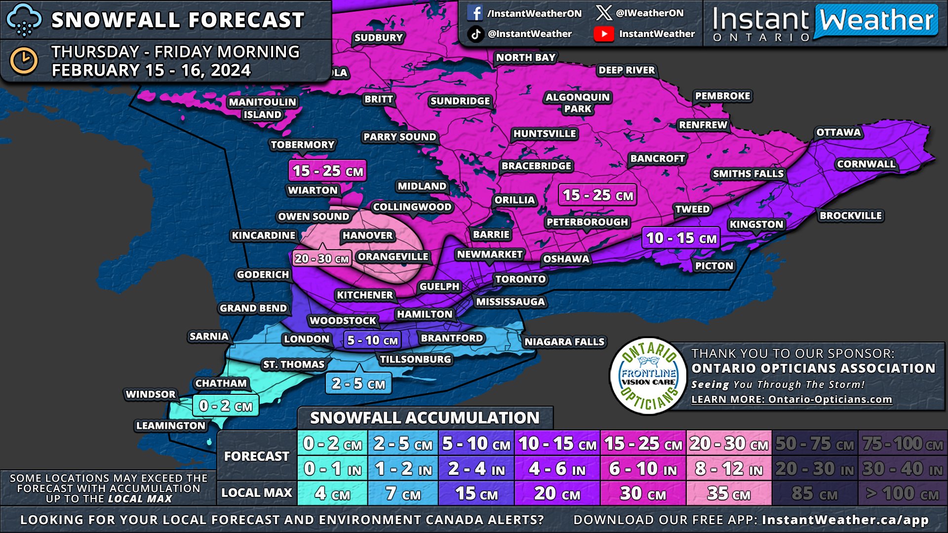
After reviewing the latest data, we've made several adjustments to our final forecast map for the snowfall set to begin later this morning and extend into the afternoon.

The worst conditions are expected during the afternoon hours with strong wind gusts leading to blowing snow and reduced visibility on the roads. Conditions will improve by the end of the day for most areas, but snow squalls will develop off Lake Huron and Georgian Bay later tonight.

The primary update is that we now anticipate the higher snowfall totals, exceeding 15cm, to be more localized to Central Ontario and the Grey-Bruce region. This is where lake effect snow is expected to enhance snowfall rates. Consequently, we've adjusted the forecast range from 15-25cm down to 15-20cm, as the higher end of the range no longer seems supported by current data. While some areas may still experience local amounts up to 25cm, such occurrences will be relatively isolated.

Areas including Port Elgin, Hanover, and Chatsworth are predicted to see around 20-30cm, combining system snow on Thursday with snow squall activity beginning late Thursday night into Friday. This zone has been narrowed as models provide greater clarity on the specific areas likely to be impacted by snow squall activity.


GOOGLE AD (NOT ENDORSED BY INSTANT WEATHER)

NOTE: YOU CAN CLICK ON THE MAP TO OPEN A ZOOMABLE IMAGE

For locations such as Kitchener, Guelph, Barrie, Peterborough, Smiths Falls, and Ottawa, snowfall totals are projected to be around 10-15cm. In the stretch from the Greater Toronto Area through to Kingston and into Extreme Eastern Ontario, we are forecasting 5 to 10cm of snow. Totals are expected to lean towards the 10cm mark further from the Lake Ontario shoreline, with those in closer proximity likely receiving closer to 5cm.

In the south, anticipated snow amounts for London and Hamilton have been revised downwards from 5-10cm to 2-5cm. Along the Lake Erie shoreline and into Deep Southwestern Ontario, minimal accumulation is expected due to a mix with rain.


earlier forecast

NOTE: YOU CAN CLICK ON THE MAP TO OPEN A ZOOMABLE IMAGE

The snow drought that has held Southern Ontario in its grip for most of February is about to come to an end this Thursday with the arrival of an intense snowmaker. This system is on track to deliver widespread snowfall, with totals ranging from 10 to 25cm, and in some areas, as much as 30cm, thanks to lake effect snow east of Lake Huron.

Accompanying the heavy snow, strong wind gusts of 40-60 km/h are anticipated throughout Thursday. These conditions are likely to cause blowing snow and poor driving visibility, significantly impacting the evening commute across the Golden Horseshoe as well as Central and Eastern Ontario.

The lake effect snow is expected to persist into the weekend, affecting the usual snowbelt areas around Lake Huron and Georgian Bay. It's possible that localized snowfall amounts (including Thursday’s storm) could reach up to 50cm by week's end, particularly in Grey and Bruce counties where lake effect snow is forecasted to be most intense.


GOOGLE AD (NOT ENDORSED BY INSTANT WEATHER)

The system will approach from the west during late Thursday morning, initially impacting areas around Lake Huron before spreading eastward through the afternoon. Deep Southwestern Ontario, including Windsor, Chatham, and the Lake Erie shoreline, might start the day with mixed precipitation, including freezing rain, before transitioning to rain as temperatures rise.

By the afternoon, heavy snow will extend across Central Ontario and into the Golden Horseshoe. There remains some uncertainty regarding the extent of mixed precipitation to the north. Consequently, areas closer to the shoreline, such as Hamilton, Burlington, Brampton, and Toronto, may see some mixed precipitation which would reduce the snowfall totals here.

Central and Eastern Ontario will continue to experience snowfall into Thursday evening. The most challenging conditions are expected during the late afternoon and early evening when both wind and snowfall rates will be at the strongest.

The system is anticipated to gradually exit the province shortly after midnight. However, lake effect snow may develop off Lake Huron and Georgian Bay, with a particularly strong squall likely between Owen Sound and Kincardine overnight. Although expected to weaken by Friday morning, lake-effect snow may still linger throughout the day, especially in Huron, Wellington, Grey, and Bruce counties.


GOOGLE AD (NOT ENDORSED BY INSTANT WEATHER)

NOTE: YOU CAN CLICK ON THE MAP TO OPEN A ZOOMABLE IMAGE

A zone with 20-30cm of snow has been added to the map to cover much of Grey and Bruce counties, including Port Elgin, Hanover, Chatsworth, and Owen Sound, to account for additional lake effect snow following the main system. Localized totals could surpass 30cm, depending on the intensity of the snow squall.

Given the latest data, we have increased confidence to adjust some areas from the 10-20cm zone to the 15-25cm zone, as this system appears to carry more moisture than initially expected. This adjustment affects much of Central Ontario and parts of Eastern Ontario.

Areas like Goderich, Kitchener, the northern Greater Toronto Area, Kingston, and the Ottawa Valley are expected to receive 10 to 15cm of snow as indicated by our earlier forecast. The exact totals here are more uncertain, and isolated pockets may exceed 15cm, depending on moisture distribution.

Near the Lake Ontario shoreline, lower snowfall totals are expected due to potential mixing and temperatures near the freezing mark. Cities such as Toronto, Mississauga, Oakville, Burlington, Hamilton, Woodstock, and London are projected to see 5-10cm of snow, though some locations, especially along the lakeshore, might not reach the 5cm mark.

The Niagara region and Deep Southwestern Ontario, including Sarnia, Chatham, and Windsor, are forecasted to see less than 5cm of snow. While significant snow accumulation isn't expected in these areas, freezing rain could pose a concern during late Thursday morning and early afternoon.


GOOGLE AD (NOT ENDORSED BY INSTANT WEATHER)

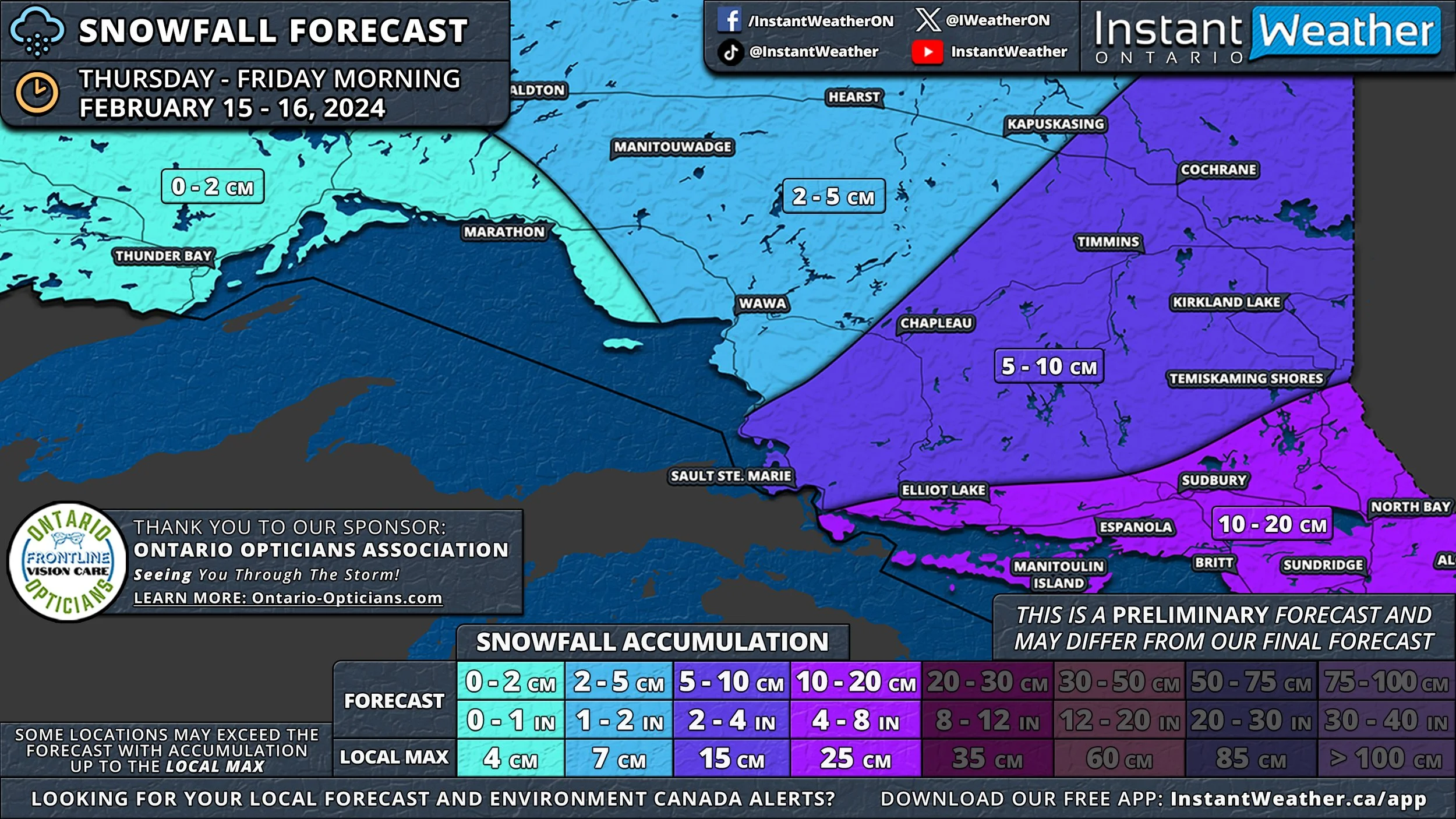
This system will also impact southern parts of Northeastern Ontario, with Elliot Lake, Sudbury, and North Bay set to receive 15 to 25cm of snow. The rest of Northeastern Ontario, including Sault Ste. Marie, Chapleau, Timmins, and Cochrane, can anticipate 5 to 15cm. Northwestern Ontario, including Thunder Bay, is expected to see less than 5cm of snow.

Say It Ain’t Snow! Winter Returns to Southern Ontario With Up to 10-20cm of Snow on Thursday

NOTE: YOU CAN CLICK ON THE MAP TO OPEN A ZOOMABLE IMAGE

February has begun somewhat quietly in terms of active weather across Southern Ontario. The most significant event this month was the record-breaking warmth experienced late last week, with temperatures soaring well into the double digits throughout much of our region. Following Wiarton Willie's bold prediction of an early spring on Groundhog Day, it momentarily seemed as though the famed groundhog was on to something.


GOOGLE AD (NOT ENDORSED BY INSTANT WEATHER)

However, the brief taste of spring was merely an illusion, as more typical seasonal temperatures have since made a comeback. We are now tracking a system that poses the first risk of widespread snowfall for the month. Expected to start early Thursday and continue into Friday, this quick-moving system could bring snowfall totals of 10 to 20cm across much of Central and Eastern Ontario.

This weather system is forecasted to move in from the west during the morning hours on Thursday, beginning with areas around Lake Huron and spreading eastward throughout the afternoon. In Deep Southwestern Ontario, including Windsor, Chatham, and along the Lake Erie shoreline, the day could start with mixed precipitation, including freezing rain, before transitioning to regular rain as warmer air prevails.

There's some uncertainty regarding how far north this mixed precipitation will extend. It could result in lower snowfall totals from London through Hamilton and into parts of the Greater Toronto Area, especially near the shoreline.

Central and Eastern Ontario are set to experience moderate to heavy snow, likely impacting the evening commute on Thursday. As this is a fast-moving system, the majority of the snow is expected to fall within a 6-12 hour period during Thursday afternoon and evening.

The snow should begin to taper off just before midnight. However, lingering flurries and light snow may continue to affect Eastern Ontario into the early hours of Friday, with the system expected to exit Southern Ontario by sunrise on Friday.


GOOGLE AD (NOT ENDORSED BY INSTANT WEATHER)

Due to the dynamic nature of this system, pinpointing exact snowfall totals for each area is challenging, as the moisture content will vary. Currently, a broad swath of Southern Ontario, from the Lake Huron shoreline through Central Ontario and into Eastern Ontario, is projected to receive 10 to 20cm of snow.

It's important to note that the higher end of the 20cm forecast is reserved for isolated areas that may experience lake enhancement, leading to locally heavier snowfall. More commonly, amounts are likely to be closer to 10cm, though some areas may see higher totals.

Snowfall totals are expected to decrease further south, with around 5 to 10cm anticipated for the London, Hamilton, and Toronto regions. This lower accumulation is attributed to the potential for mixed precipitation and lower snowfall ratios.


GOOGLE AD (NOT ENDORSED BY INSTANT WEATHER)

The Windsor, Chatham, Sarnia, and Niagara regions are forecasted to receive less than 5cm of snow due to even greater mixing and limited opportunities for snow accumulation.

This system is also expected to impact the southern part of Northern Ontario, with Elliot Lake, Sudbury, and North Bay poised to see 10 to 20cm of snow. The rest of Northeastern Ontario, including Sault Ste. Marie, Chapleau, Timmins, and Cochrane, can expect around 5 to 10cm. Northwestern Ontario, including Thunder Bay, is forecasted to receive less than 5cm of snow.

Willie Was Right! Early Spring-Like Weather for Southern Ontario; Record Breaking Double-Digit Temperatures on Friday

NOTE: YOU CAN CLICK ON THE MAP TO OPEN A ZOOMABLE IMAGE

At the beginning of February, Wiarton Willie, who did not see his shadow, predicted an early spring for Southern Ontario. It appears that Willie's prediction may indeed reflect the weather pattern as we approach the latter part of this week.

After enjoying several consecutive days of sunshine, this pleasant streak is unfortunately expected to end, with clouds and fog rolling in on Thursday and Friday. It will resemble a Vancouver Or Seattle winter, a trend that has been persistent over the last few months. Early Friday, Southern Ontario will see some scattered showers that will continue throughout the day, but these showers will bring with them a surge of warm air.


GOOGLE AD (NOT ENDORSED BY INSTANT WEATHER)

In parts of Southwestern Ontario and areas of the Golden Horseshoe, temperatures could reach the 10°C mark on both Thursday and Friday. Friday is anticipated to be the warmest day, with temperatures in Deep Southwestern Ontario nearing the mid-teens. Most areas have temperature records ranging from 8°C to 12°C, records that might be shattered on Friday, according to current models.

Those in Windsor, Chatham, Sarnia, London, Woodstock, and Newmarket can expect maximum temperatures between 10 to 14°C, likely making this the warmest area in the province. Near the Lake Erie, Lake Huron, and Lake Ontario shorelines, as well as in the Barrie and Peterborough areas, it will still be quite warm, with temperatures ranging from 8 to 12°C.

In Central and Eastern Ontario, temperatures are predicted to be slightly cooler, falling short of double digits and ranging from 6 to 10°C. Further north, temperatures are expected to hover in the mid-single digits for Algonquin Park and Northeastern Ontario.


In addition to the warmth, fog starting Wednesday night around Lake Erie and the Golden Horseshoe will pose a challenge, with near-zero visibility creating hazardous driving conditions. This may result in some school bus cancellations on Thursday and Friday mornings. The fog is expected to persist into the weekend.


GOOGLE AD (NOT ENDORSED BY INSTANT WEATHER)

Looking ahead to next week, a return to seasonal temperatures around the freezing mark is expected in most areas. There are signs that we might enter a colder pattern by the end of next week, extending into mid-February, potentially bringing several opportunities for accumulating snow later in the month. However, it's still too early to confirm, and the forecast could change!

Canada’s Groundhogs, Lobster Split on if It Will Be an Early Spring This Year

NOTE: YOU CAN CLICK ON THE MAP TO OPEN A ZOOMABLE IMAGE

The curtain has fallen on Groundhog Day 2024, and the forecasts from our esteemed weather-predicting groundhogs—and a lone lobster—are in, offering a split decision that mirrors the vast and varied Canadian landscape.


GOOGLE AD (NOT ENDORSED BY INSTANT WEATHER)

In the Maritimes, Shubenacadie Sam of Nova Scotia brought cheer with his prediction of an early spring, a sentiment supported by Quebec’s new groundhog meteorologist, who is carrying on the legacy of the late Fred la Marmotte with a similar spring-forward forecast.

Lucy the Lobster, however, provided a stark contrast, casting her shadow on the seabed and predicting a longer winter for Nova Scotia.


GOOGLE AD (NOT ENDORSED BY INSTANT WEATHER)

The spring chorus was joined by Ontario's Wiarton Willie and the famed Punxsutawney Phil from the United States, both of whom failed to see their shadows, suggesting an early end to winter.

In a surprising twist, the story changed out in the Prairies, as Manitoba Merv observed his shadow, heralding six more weeks of winter.


GOOGLE AD (NOT ENDORSED BY INSTANT WEATHER)

This chilly predictions was later seconded by Alberta's Balzac Billy, who also saw his shadow, adding weight to the wintry forecast.

Now, with an even split of three forecasts for an early spring and three for a prolonged winter, Canadians are left to wonder what the coming weeks will truly hold. Will the hopeful predictions of an early spring prevail, or will the winter warnings ring true?

With this mixed bag of predictions, the end of winter remains as mysterious as the weather itself. Only the passing of the weeks will reveal the true accuracy of our furry and clawed forecasters’ divinations.


GOOGLE AD (NOT ENDORSED BY INSTANT WEATHER)

‘Ice Day’ Forecast: Freezing Rain Likely to Cancel School Buses Across Eastern Ontario for Another Day on Friday

NOTE: YOU CAN CLICK ON THE MAP TO OPEN A ZOOMABLE IMAGE


GOOGLE AD (NOT ENDORSED BY INSTANT WEATHER)

On Friday morning, Eastern Ontario faces yet another risk of freezing rain, prompting Environment Canada to issue freezing rain warnings. Given these warnings and the anticipated hazardous driving conditions during the school day, it is likely that many school boards will cancel buses for yet another day.

For some school boards, this could be the second or even third consecutive ‘ice day’. Meanwhile, the current fog over Southwestern Ontario and parts of the Golden Horseshoe is expected to clear up by morning, making another ‘fog day’ unlikely.


GOOGLE AD (NOT ENDORSED BY INSTANT WEATHER)

School boards with the highest chance of bus cancellations include those in Ottawa, Upper Canada, Renfrew, and the northern regions of the Tri-Board. These areas face a 90% chance of an ‘ice day’ on Friday.

In the southern part of the Tri-Board, covering Kingston and Belleville, cancellations are still considered likely, though with less certainty, due to the area being under a special weather statement rather than a freezing rain warning.

For those in Peterborough and Haliburton, the probability of an ‘ice day’ ranges from 50 to 75%. The rest of Central Ontario has a 10 to 25% chance, as icy conditions are possible, but it remains questionable whether they will be severe enough to warrant bus cancellations. The likelihood of an ‘ice day’ in the rest of Southern Ontario is less than 10%.


Disclaimer: Instant Weather has zero authority when it comes to bus and school closures. It is completely up to the school boards, bus companies, local authorities, and parents to decide what is best for their children. This is our best guess based on our forecast.


GOOGLE AD (NOT ENDORSED BY INSTANT WEATHER)

Another Icy Day Ahead for Eastern Ontario; Second Round of Prolonged Freezing Rain on Friday Morning

NOTE: YOU CAN CLICK ON THE MAP TO OPEN A ZOOMABLE IMAGE

After being coated in ice all day Wednesday, Eastern Ontario is bracing for another round of freezing rain on Friday. This upcoming bout of freezing rain is expected to impact many of the same areas that were heavily affected by Wednesday's icing event.

A system moving into Southern Ontario late Thursday will bring mostly rain to Southwestern Ontario and the Golden Horseshoe region.

However, this system will run into the cold air lingering over Eastern Ontario, which was responsible for Wednesday's significant freezing rain. This will lead to the development of more freezing rain, starting early Friday morning along the Dundalk Highlands and extending eastward into the Ottawa Valley.

Freezing rain is forecast to continue across Eastern Ontario throughout the morning and into the afternoon. By late Friday afternoon, we could see an additional 5-10mm of ice accumulation. Considering the existing layer of ice from the previous event, this additional freezing rain poses an increased risk of power outages and hazardous road conditions.


GOOGLE AD (NOT ENDORSED BY INSTANT WEATHER)

Regarding ice accumulation, it's important to note that the amounts mentioned are general estimates of freezing rain from the sky. Actual ice accumulation on surfaces will vary depending on the surface type, and local dynamics are difficult to predict in a broad-scale forecast.

The heaviest icing is anticipated around Bancroft, Perth, Ottawa, and Cornwall, with around 5-10mm of ice accumulation possible. It's important to note that some models predict a changeover to regular rain by late morning, particularly in the southern regions, which could limit total ice accumulation.

Elsewhere in Eastern Ontario, ice accretion of 2 to 5mm is expected before transitioning to rain. While the Kingston area was severely impacted by the last event, temperatures are forecast to rise above freezing quickly enough to prevent significant icing along the Lake Ontario shoreline.

Additionally, higher elevations northwest of the Greater Toronto Area, including Orangeville and Shelburne, may experience a few millimetres of ice as the cold air persists for a longer duration.

In Central Ontario, including Muskoka, Simcoe County, and northern parts of the Greater Toronto Area, some freezing drizzle is possible, but less than 2mm of ice accumulation is expected, as the conditions should quickly change over to rain.

Also notable is that parts of Southwestern Ontario could pick up around 15-30mm of rain during the overnight and into Friday morning. The rest of Southern Ontario not seeing the freezing rain can expect 10-20mm of rain, locally up to 25mm. All precipitation will come to an end by the dinner hour.


GOOGLE AD (NOT ENDORSED BY INSTANT WEATHER)

‘Ice/Fog Day’ Forecast: Significant Freezing Rain Almost Certain to Cancel School Buses on Thursday in Eastern Ontario

NOTE: YOU CAN CLICK ON THE MAP TO OPEN A ZOOMABLE IMAGE


GOOGLE AD (NOT ENDORSED BY INSTANT WEATHER)

As of Wednesday evening, Eastern Ontario is experiencing ongoing prolonged freezing rain, expected to continue throughout the night. Although the freezing rain will lessen after midnight, it will significantly affect road conditions by morning. Consequently, there is a high likelihood of school bus cancellations in many regions on Thursday.

Additionally, foggy conditions are affecting Southwestern Ontario and parts of the Golden Horseshoe. The fog is anticipated to thicken overnight and linger into the morning, potentially leading to localized bus cancellations in rural areas around London and east of Lake Huron.


GOOGLE AD (NOT ENDORSED BY INSTANT WEATHER)

NOTE: YOU CAN CLICK ON THE MAP TO OPEN A ZOOMABLE IMAGE

The greatest chance of an ‘ice day’ is in much of Eastern Ontario, excluding Ottawa. Rural school boards in this area have a 90% chance of school bus cancellations, while the City of Ottawa has a 75% chance, as this school board is typically more stringent with cancellations. We don’t expect the conditions to be safe for bus operations, but some school boards, particularly in urban areas with less reliance on buses, might decide differently.

In parts of Central Ontario, including Muskoka, Haliburton, Kawartha Lake, Peterborough, northern Durham, and northern Simcoe County, the probability of an ‘ice day’ remains fairly strong. Chances range from 25% in the more western and southern areas to 75% in Peterborough and Haliburton.

These lower chances are due to the expected less intense freezing rain and ending earlier in the night, potentially allowing roads to be cleared in time for the morning bus run. However, this will heavily depend on local road conditions, and the actual probability could be higher, though we don’t have enough confidence to increase these estimates.

In Southwestern Ontario, there is a low chance of a ‘fog day’ in areas around London, including Middlesex, Oxford, and Elgin counties, which experienced cancellations on Wednesday. The surrounding regions have a 5% chance, as cancellations can't be entirely ruled out, but most school boards are expected to operate as usual.


Disclaimer: Instant Weather has zero authority when it comes to bus and school closures. It is completely up to the school boards, bus companies, local authorities, and parents to decide what is best for their children. This is our best guess based on our forecast.


GOOGLE AD (NOT ENDORSED BY INSTANT WEATHER)

Significant Freezing Rain Threat for Eastern Ontario Including Ottawa & Kingston on Wednesday

NOTE: YOU CAN CLICK ON THE MAP TO OPEN A ZOOMABLE IMAGE

An approaching system is set to move across Southern Ontario later on Wednesday, leading to a prolonged risk of freezing rain in much of Eastern Ontario. This system will bring warmer air, resulting in foggy and rainy conditions throughout Southwestern Ontario and the Golden Horseshoe area.

As the system advances northeast, it will encounter temperatures below freezing at the surface in Eastern and Central Ontario. The warm air will overtake the colder air aloft, creating ideal conditions for freezing rain.

Current forecasts indicate that the risk of freezing rain could last between 6 to 12 hours in parts of Eastern Ontario, beginning Wednesday afternoon and continuing through the evening into the early hours of Thursday.

In the hardest-hit regions, significant icing is possible, with more than 10mm of accumulation expected by early Thursday morning. This is likely to lead to icy road conditions and potential power outages as ice builds up on tree branches and power lines.


GOOGLE AD (NOT ENDORSED BY INSTANT WEATHER)

Through the morning hours, drizzle and fog have already been affecting Southwestern Ontario and the Greater Toronto Area. This precipitation is expected to spread northward in the afternoon, meeting the colder air and forming a band of freezing rain from Lake Simcoe eastward through Peterborough to Kingston by mid-afternoon.

This freezing rain will persist, causing steady icing throughout the afternoon and evening. However, there is some disagreement among the models about how long the below-freezing temperatures will last. Some models suggest a gradual warm-up by evening in areas around Lake Simcoe and the Lake Ontario shoreline, which could lessen the ice accumulation in the Muskoka, Belleville, and Kingston regions.

Other models, however, indicate that the cold air will remain firmly in place with little temperature fluctuation until Thursday morning. This scenario would result in widespread icing from this afternoon into early Thursday.


GOOGLE AD (NOT ENDORSED BY INSTANT WEATHER)

In the Ottawa Valley, especially south of Ottawa, there is more confidence in the forecast. Conditions are expected to be prime for freezing rain from late afternoon into the overnight hours. Further north, in regions like Pembroke, Renfrew, and Ottawa, ice pellets may mix in, leading to less icing but still severe impacts on travel and power.

The freezing rain is expected to taper off in the early hours of Thursday, but with temperatures remaining low in Eastern Ontario, travel conditions will still be treacherous for the Thursday morning commute. Widespread school bus cancellations are likely in this region on Thursday.

Fog will persist in Southwestern Ontario and the GTA. While it may recede slightly later on Wednesday, it's likely to return overnight in some areas.


GOOGLE AD (NOT ENDORSED BY INSTANT WEATHER)

NOTE: YOU CAN CLICK ON THE MAP TO OPEN A ZOOMABLE IMAGE

Regarding ice accumulation, it's important to note that the amounts mentioned are general estimates of freezing rain from the sky. Actual ice accumulation on surfaces will vary depending on the surface type, and local dynamics are difficult to predict in a broad-scale forecast.

The heaviest ice accumulation is expected between Ottawa and Kingston, with areas like Brockville, Smiths Falls, Perth, Tweed, and Bancroft potentially seeing up to 10 to 15mm of freezing rain. Other parts of Eastern Ontario, including Ottawa, Kingston, and Peterborough, are likely to experience several hours of freezing rain, with ice accumulations ranging from 5 to 10mm.


GOOGLE AD (NOT ENDORSED BY INSTANT WEATHER)

In Central Ontario and parts of the GTA, lesser amounts of freezing rain are forecast, with around 2-5mm of ice possible for Muskoka, Kawartha Lakes, and parts of York and Durham regions. Less than 2mm is expected for Simcoe County and higher elevations northwest of the GTA. However, these areas could see higher amounts depending on how quickly temperatures rise above freezing.

‘Ice Day’ Forecast: Questionable Chance of School Bus Cancellations on Wednesday in Parts of Southern Ontario

NOTE: YOU CAN CLICK ON THE MAP TO OPEN A ZOOMABLE IMAGE


GOOGLE AD (NOT ENDORSED BY INSTANT WEATHER)

Freezing rain is currently affecting parts of Southwestern Ontario and the northern fringes of the Greater Toronto Area, and it's expected to persist past midnight. Although the freezing rain is likely to stop well before the morning school bus schedule, it could still result in icy conditions. Consequently, there's a small possibility of an ‘ice day’.

In Eastern Ontario, freezing rain is anticipated on Wednesday afternoon. The majority of this activity is expected in the late afternoon, so school bus operations on Wednesday should not be significantly impacted. However, Environment Canada might issue alerts by morning, which could lead some weather-sensitive school boards to proactively cancel buses.


GOOGLE AD (NOT ENDORSED BY INSTANT WEATHER)

For the broader swath of Southwestern Ontario extending into the For the area around the Dundalk Highlands, including Orangeville and Wellington County, there's a 25% chance of school bus cancellations due to potentially heavy freezing rain. Moving east, the Tri-Board regions around Belleville and Kingston also have a 25% chance of cancellations. Here, freezing rain could start in the early afternoon, and this school board is more inclined to cancel buses under such conditions.

Surrounding school boards on the outskirts of the Golden Horseshoe and into Eastern Ontario face a 5-10% chance of an ‘ice day’. While it’s fairly unlikely, we cannot completely discount the possibility of a few school boards cancelling buses based on local road conditions.


Disclaimer: Instant Weather has zero authority when it comes to bus and school closures. It is completely up to the school boards, bus companies, local authorities, and parents to decide what is best for their children. This is our best guess based on our forecast.


GOOGLE AD (NOT ENDORSED BY INSTANT WEATHER)

‘Ice Day’ Forecast: Freezing Rain Risk Likely to Cancel School Buses on Tuesday in Parts of Southwestern Ontario

CENTRAL & EASTERN ONTARIO HAVE LESS THAN A 5% CHANCE OF BUS CANCELLATIONS


GOOGLE AD (NOT ENDORSED BY INSTANT WEATHER)

A mix of messy precipitation is set to sweep into Southwestern Ontario overnight, with a freezing rain warning already in effect for Windsor and Chatham. This is expected to lead to icy road conditions, which will persist throughout Tuesday morning. Consequently, school bus cancellations are highly likely in the most severely affected areas.

The Windsor area is particularly at risk, with several hours of freezing rain forecasted overnight into Tuesday morning. The likelihood of an ‘ice day’ in this region stands at a high 90%. Meanwhile, the Chatham region faces a 75% chance of school bus cancellations.

As we move northeast, the probability of school bus cancellations diminishes slightly due to the later onset of precipitation. The Sarnia, Lambton, Middlesex, and Elgin regions have a 50% chance of cancellations. The City of London and nearby areas like Exeter, Stratford, and Oxford face a lower chance, at about 25%.


GOOGLE AD (NOT ENDORSED BY INSTANT WEATHER)

For the broader swath of Southwestern Ontario extending into the Greater Toronto Area, the likelihood of school bus cancellations is relatively low, ranging from 5 to 10%. While conditions may not be severe enough for most school boards to cancel buses, we cannot completely dismiss the possibility of one or two boards proactively cancelling in anticipation of the afternoon snowfall.

Central and Eastern Ontario are not expected to be impacted until later on Tuesday, so no cancellations are anticipated in these regions. As a result, our forecast map does not highlight these areas, given that the probability of cancellations there is below 5%.


Disclaimer: Instant Weather has zero authority when it comes to bus and school closures. It is completely up to the school boards, bus companies, local authorities, and parents to decide what is best for their children. This is our best guess based on our forecast.


GOOGLE AD (NOT ENDORSED BY INSTANT WEATHER)

Messy Week Ahead as Multiple Rounds of Heavy Snow and Freezing Rain Target Southern Ontario Starting Tuesday

NOTE: YOU CAN CLICK ON THE MAP TO OPEN A ZOOMABLE IMAGE

After a mild start in December, the new year has brought a shift in the weather pattern across Southern Ontario. January has definitely felt more like winter, with our first prolonged deep freeze leading to several instances of snow squalls in the past few weeks.

However, it seems the winter spell is about to break as we welcome milder air for the final days of January. The warm-up won't be uniform across the region, though. For instance, the Ottawa Valley and northern parts of Central Ontario will continue to experience colder temperatures, with overnight lows below -10°C and wind chills near -20°C for much of the week.

In contrast, areas in Southwestern Ontario and around the Golden Horseshoe are expected to see temperatures closer to, or even slightly above, the freezing mark later this week.

Several systems are forecast to move across Southern Ontario in the coming days. With temperatures hovering around freezing, these systems are likely to bring a mix of winter weather, including heavy snow, ice pellets, freezing rain, and even some regular rain.


GOOGLE AD (NOT ENDORSED BY INSTANT WEATHER)

The first system is set to impact Southern Ontario late Monday, continuing through Tuesday. This could affect the Tuesday morning commute, particularly in Southwestern Ontario and the Greater Toronto Area.

Current predictions indicate that precipitation will primarily be heavy snow, stretching from Lake Huron across the Golden Horseshoe and into southern parts of Central and Eastern Ontario. By Tuesday's end, total snowfall could reach up to 10cm in some areas.

A more complex situation is expected further south in Deep Southwestern Ontario and along the Lake Erie shoreline. A mix of snow, ice pellets, and prolonged freezing rain could lead to icy road conditions in this region.


GOOGLE AD (NOT ENDORSED BY INSTANT WEATHER)

Light snow and ice pellets have already started in Southern Ontario as of Monday afternoon, ahead of the main system. This is expected to taper off through the evening, though some patchy freezing drizzle could persist around the Lake Erie shoreline.

The initial bands of precipitation associated with the system will reach the Windsor area around midnight, with freezing rain being the primary concern. This risk will continue overnight and spread to Chatham and Sarnia by mid-morning Tuesday, making for potentially icy roads and delays. School bus cancellations are also a possibility due to the freezing rain threat.

By lunchtime Tuesday, the slow-moving system should reach London, Kitchener, Hamilton, and Toronto. It will likely start as light to moderate snowfall, continuing into the evening. Although the snowfall rates may not be intense, the prolonged nature of the event means that even a centimetre or two per hour will accumulate significantly over 6-12 hours.

Later in the afternoon, areas in Deep Southwestern Ontario and along the Lake Erie shoreline should warm up enough to transition from freezing rain to regular rain. A similar changeover to ice pellets and freezing rain is anticipated in the London to Hamilton corridor by evening, possibly resulting in slightly lower snowfall totals compared to areas further north.


GOOGLE AD (NOT ENDORSED BY INSTANT WEATHER)

Snow is expected to begin in the southern part of Central and Eastern Ontario, from Barrie to Kingston, in the late afternoon or early evening, continuing overnight into Wednesday morning. Further north, areas like Huntsville, Algonquin Park, and Ottawa can expect less snow, as the heaviest precipitation is forecast to remain south.

The system should start clearing from west to east just after midnight and exit the province by late Wednesday morning. However, a brief respite in precipitation will be followed by another wave of moisture from the southwest late Wednesday.

This next system looks to bring more rain for Southwestern Ontario and the Golden Horseshoe, while Central and Eastern Ontario could face a prolonged risk of freezing rain lasting into Thursday. Further details on this will be provided in a separate forecast.

The impact of the first system will vary significantly. Regions east of Lake Huron through the Kitchener area and around the Greater Toronto Area are likely to see mostly snow, with additional accumulations of 6 to 12cm by the end of Tuesday. Lower snowfall amounts of 2 to 6cm are expected further north in parts of Central and Eastern Ontario.


GOOGLE AD (NOT ENDORSED BY INSTANT WEATHER)

NOTE: YOU CAN CLICK ON THE MAP TO OPEN A ZOOMABLE IMAGE

The situation becomes more complex southwestward, with a zone stretching from Sarnia through London to the Hamilton/Niagara region likely to experience a mix of ice pellets and snow. A few centimetres of ice pellets, along with up to 4-8cm of snow, is possible here. Brief freezing rain later on Tuesday shouldn't be ruled out as the mixing line moves northward.

In Deep Southwestern Ontario and along the Lake Erie shoreline, the primary risk is ice pellets and freezing rain. The precipitation will likely start as ice pellets early Tuesday, transitioning to freezing rain by late morning or early afternoon. Some rain may also occur in the evening as temperatures rise above freezing. Total accumulations are hard to gauge, but expect around 2-6cm of snow, followed by up to 2cm of ice pellets, and then several hours of freezing rain.

The Windsor and Chatham areas are forecast to see mostly freezing rain from this system, with ice accumulation up to 2-4mm before transitioning to regular rain. There could also be 10-15mm of rain from the system after the switchover occurs.