Soggy Last Weekend of April Will Bring Over 50mm of Rain to Parts of the Maritimes
/
NOTE: YOU CAN CLICK ON THE MAP TO OPEN A ZOOMABLE IMAGE
As we come close to the end of the month, the April Showers will hit in full force this weekend, with at least 20mm of rain expected across the Maritimes by the end of Monday.
Light rain will start to push into New Brunswick from the west in the early morning hours of Saturday, tracking from southwest to northeast. This will be a brief first round of rain that will cross through New Brunswick and into PEI during the morning. In Northern New Brunswick, the cool air could result in some brief light snow falling during the morning, but we’re not expecting much accumulation and it will melt with rain that will follow.
The Annapolis Valley and Cumberland County could see a bit of rain along the southern edge of this initial band as it crosses the region, however, the majority of the rain will come in the following round.

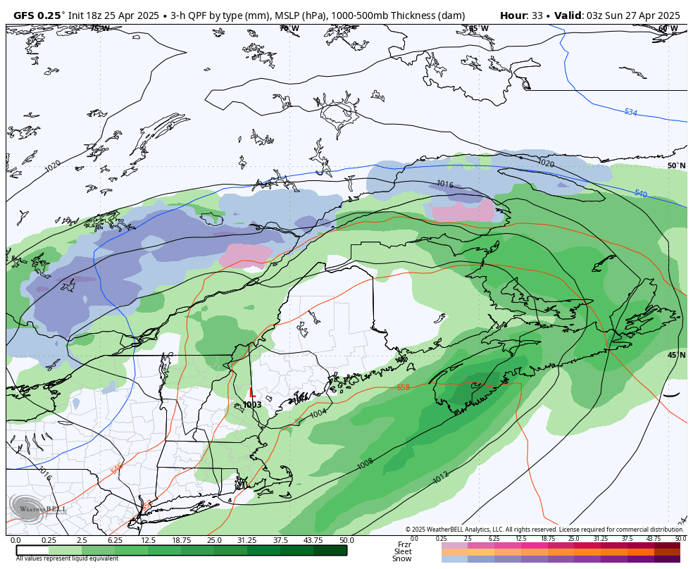
Model Image showing the location and intensity of snow (Blue) and Rain (Green) at 3AM AT Saturday
Not far behind the initial round, the main band of more widespread rain will make its way into the region beginning late Saturday morning. The rain will be very heavy at times as it crosses through the Maritimes for the remainder of the day and into Sunday afternoon.
In New Brunswick, the rain will be heavy during the afternoon and evening before becoming lighter later in the evening and ending overnight. Prince Edward Island can expect the heavier rain to begin in the evening, which will persist into Sunday morning before it tapers off in the early afternoon.
Nova Scotia will see the heaviest rain for an extended period of time with this system. The rain will intensify in Western Nova Scotia starting early Saturday evening and it will spread eastward across the province throughout the evening. It will continue overnight and for most of Sunday morning. It will start to taper off from west to east in the mid-morning, but some areas, particularly along the Atlantic Coast, can expect to see steady rainfall continue into the evening, leading to over 50mm falling.
Model Image showing the location and intensity of snow (Blue), freezing rain (Pink), and Rain (Green) at 12AM aT Sunday
Mid-Sunday morning will see the return of some scattered showers across New Brunswick, which will reach PEI in the late afternoon and continue into early Monday morning. This final lingering band of light rain will push southeastward into Nova Scotia around sunrise Monday and will gradually dissipate in the afternoon and evening.
The entirety of the Maritimes can expect at least 20mm and a widespread 30-50mm is forecast for the region. In Western Nova Scotia, along the Atlantic Coast and into Cape Breton, the heaviest rain is expected, with periods of downpours, which will result in over 50mm of rain and even up to 75mm. If a downpour happens to settle over a particular area for a longer period, closer to 90mm of rainfall is not out of the question.
Strong wind gusts will accompany the rain, reaching up to 60km/h across much of the region Saturday night and Sunday morning. The winds will be stronger in parts of Nova Scotia, especially along the Atlantic Coast and through the Highlands, where gusts could exceed 70km/h, while gusts up to 100km/h are likely in northwestern Cape Breton.
Hopefully with all this rain and some warmer temperatures to end the month, we’ll see plenty of May Flowers!


