🌪️ ‘Tornado Tuesday’ Might Make a Return in Southern Ontario Next Week ⛈️
/
NOTE: YOU CAN CLICK ON THE MAP TO OPEN A ZOOMABLE IMAGE
TUESDAY, APRIL 29, 2025: As I write this discussion (2am on Friday, April 25th, 2025), we’re quite a few days away from Tuesday, April 29th, 2025. Having said that, I’ve been carefully monitoring this strengthening trend on the forecast models for several days now and seeing them consistently suggesting an enhanced risk (3/5) for severe thunderstorms across much of Southern Ontario with the potential for isolated tornado activity. From Windsor, up through Barrie and perhaps even reaching parts of Eastern Ontario and the GTHA.
Typically, five days out is a lifetime for forecasting severe weather. Having said that, in rare circumstances you can see these strong environments coming from a mile away and this looks like this could be one of those events. Especially when we have a lot of data supporting the risk, which we’ll discuss further down the page.
Could this all change? You betcha. After more than a decade of forecasting severe weather in Ontario and across Canada, I’m no stranger to the potential for a “bust”. I could write this article and the entire system could vanish from the weather models. Tuesday could end up being just another typical spring day. Here’s hoping that’s the case. If, however, that is not the case and the trends we’re seeing in the models are correct, this is the type of event that requires getting the word out well in advance so that alternative plans can be considered and you can review your safety plan with your loved ones.
FRIDAY, APRIL 25, 2025: I should probably mention that we will have a risk for isolated thunderstorms today (Friday) and there is a marginal (low) risk for severe storms in deep southwestern Ontario later this afternoon and into the evening hours. Briefly severe hail and strong wind gusts are possible. At this point, it doesn’t look particularly intense but we’ll be keeping a close eye on it, nonetheless.
🔎Reviewing Models & Available Data For Tuesday

NOTE: YOU CAN CLICK ON THE MAP TO OPEN A ZOOMABLE IMAGE
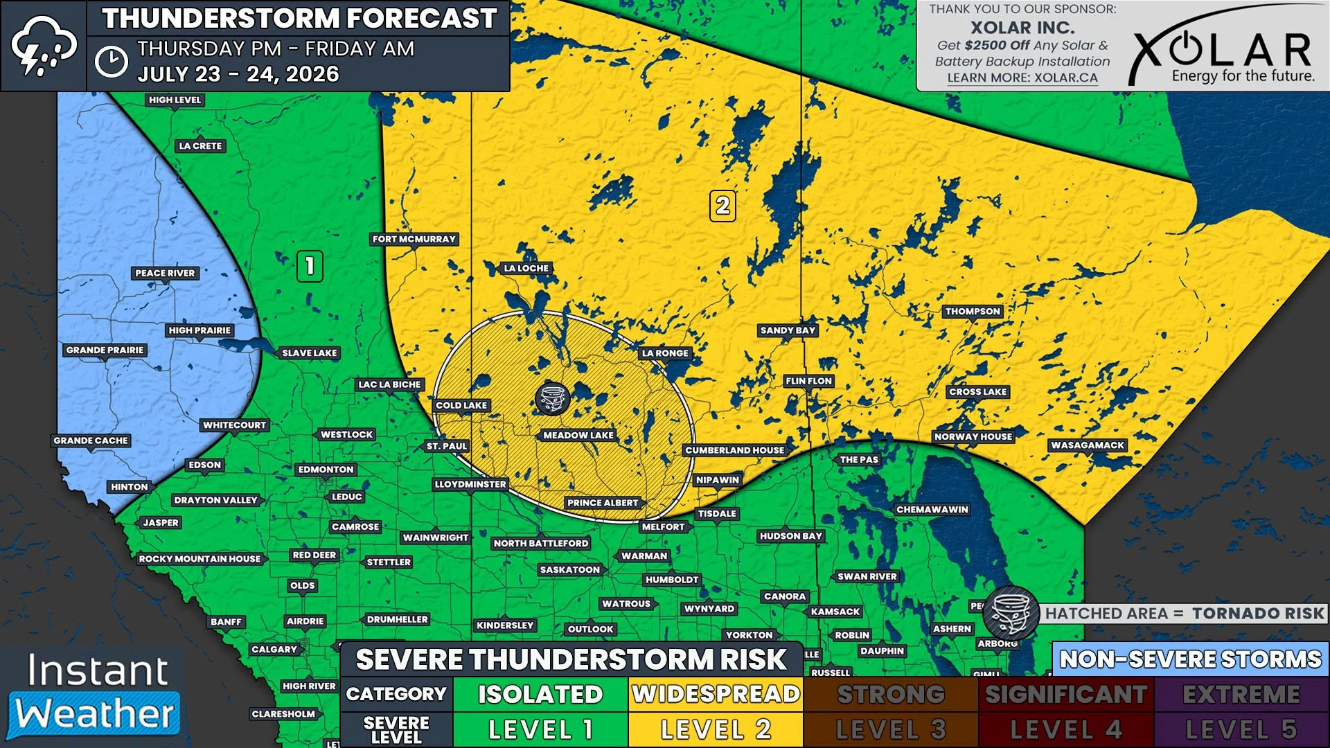
Typically, we like to compare the data from several different model systems. In this case, we’ll compare the American model, the European model and our own Canadian model. In the image above, we’re looking at the American model and what we’re reviewing is the severe weather “energy” that the storms are going to have available to them. The highest levels reaching almost 2,500 (in yellow/orange), which puts this event in the ‘Enhanced 3/5’ category, in my personal opinion.
For context, we can have marginal severe weather with energy levels as low as 500. And on the high-end, CAPE can reach as high as 5,000+ in the most extreme cases. So we’re somewhere in the middle, with totals potentially reaching greater than 1,000 and less than 3,000, at least, at this point.

NOTE: YOU CAN CLICK ON THE MAP TO OPEN A ZOOMABLE IMAGE
Above is the Euro model, showing similar strong values to the American model in the deep southwest at 2pm. But, as you’ll see below, the energy progresses further east as we approach 5pm on Tuesday.

NOTE: YOU CAN CLICK ON THE MAP TO OPEN A ZOOMABLE IMAGE
Above, we’ve got the 5pm timeframe from the Euro model. Showing organized energy values in place for the expected thunderstorms in the afternoon and evening hours.

NOTE: YOU CAN CLICK ON THE MAP TO OPEN A ZOOMABLE IMAGE
While we’re taking a look at the European model, one interesting product they have is an estimated lightning density over several hours. As you can see in red, orange yellow and blue, quite a lot of thunderstorms are expected throughout the afternoon and into the evening hours, taking advantage of all that storm energy we discussed previously.
Below, let’s take a look at the Canadian energy for Tuesday. For some reason, the data looks really blocky. Not sure why PivotalWeather.com (the model provider we’re using for these images) is processing the Canadian model this way but perhaps, it’s coming that way directly from Environment Canada.
Regardless, a similar trend is showing up on the Canadian model that we’re seeing on both the European and American models. And with that, we have what is considered “model agreement”. And it’s not just these three models, other forecasting products called ‘Ensembles’ have 30+ model members and the vast majority are showing a strong severe thunderstorm risk for Tuesday.

NOTE: YOU CAN CLICK ON THE MAP TO OPEN A ZOOMABLE IMAGE
This Canadian model image above is for 2pm on Tuesday. And similar to the European model data where we showed two separate timestamps (2pm and 5pm), this energy will push east, through the Barrie area and potentially into the GTHA and parts of Eastern Ontario through the afternoon and evening hours. Energy values look similar to the other two models, supporting the potential for an Enhanced Risk of severe thunderstorms.
Some other data worth noting in the image below is from the Storm Prediction Center (SPC) in Norman, Oklahoma. Not surprisingly, they are already showing a risk map for Tuesday, which they typically only show this far out when there is a strong system expected and a lot of agreement within the weather models.
You can see that southwestern Ontario gets highlighted in this risk area from Windsor, through Chatham-Kent and Sarnia, cutting off just shy of London. Having said that, the SPC’s only job is to forecast for the US. And as we’ve seen historically with them over the past decade, if they’re showing an extended range forecast that highlights parts of Southern Ontario, we could be in for quite the storm system much further into the Province than is shown below.

NOTE: YOU CAN CLICK ON THE MAP TO OPEN A ZOOMABLE IMAGE
And in the final image below, we’re looking at a Machine Learning (AI) based severe weather estimation from the US. In this case, they cut off the data at the international border but by simply using your imagination, it’s clear that Southern Ontario is included in this risk region.

NOTE: YOU CAN CLICK ON THE MAP TO OPEN A ZOOMABLE IMAGE
🤔Final Thoughts:
If these trends continue and this system does not decide to vanish from all the models suddenly (here’s hoping it does), Tuesday is shaping up to be a strong or potentially significant severe thunderstorm risk. All modes of severe weather could be on the table with damaging wind gusts, torrential rain, isolated flooding, large hail, intense lightning and the potential for isolated tornadoes, some of which could be strong. Here’s hoping that it weakens into a marginal risk or vanishes all together!
Having said that, now would be a good time to start reviewing your storm safety plan and discussing your plans for Tuesday if this system does decide to show up and affect Southern Ontario.
Disclaimer: By using our services and any associated content, this means you implicitly agree to use the services and data available as is with no warranty issued or implied and should be used for informational purposes only. Any use of this data for decision making processes is done at the sole risk of the end user. Do not reproduce or disseminate our forecasts and content without explicit consent of Instant Weather, Inc.