Mid-Week Strong Severe Risk for Southern Ontario on Wednesday; Tornadoes Possible in the Ottawa Valley
/
NOTE: YOU CAN CLICK ON THE MAP TO OPEN A ZOOMABLE IMAGE
It has been a relatively quiet month for severe weather across Southern Ontario, aside from the significant rain that caused flash flooding in parts of the Greater Toronto Area last week. To put it into perspective, we have only seen two confirmed tornadoes this month, both occurring on July 10th in London.
However, the quiet period might be coming to an end with a potent storm threat for parts of Central and Eastern Ontario on Wednesday. All severe hazards are possible, including large hail, damaging wind gusts, and maybe even one or two tornadoes.
The storm threat will kick off quite early, with developing storms over Georgian Bay during the mid to late morning hours on Wednesday. Based on the latest models, these storms are likely to track into regions east of Georgian Bay, such as Parry Sound, Muskoka, and Simcoe County, between 10 AM and 1 PM. They could present some marginal severe threats, including strong wind gusts and hail up to the size of quarters. An isolated tornado can’t be ruled out.
By early afternoon, we expect these morning storms to begin merging into one main cluster of storms somewhere around Lake Simcoe. This cluster will be tracking into a more established environment through Bancroft and extending into the Ottawa Valley. As a result, the storm will likely intensify throughout the early to mid-afternoon hours.
There is some disagreement on the exact placement of this storm, but almost all models agree on the intensity. This is where we believe the tornado threat is the strongest.
Further storm development is possible to the southwest of the cluster, extending through Peterborough into parts of the Greater Toronto Area during the afternoon hours. These storms will gradually track to the east or northeast, although they could move quite slowly, leading to a potential flash flooding threat. Hail and strong wind gusts are also possible. An isolated tornado can’t be ruled out.
The storm risk will come to an end by early evening for those around Lake Simcoe and the Greater Toronto Area. For Eastern Ontario and the Ottawa Valley, expect the storms to fizzle out around 9 to 10 PM.
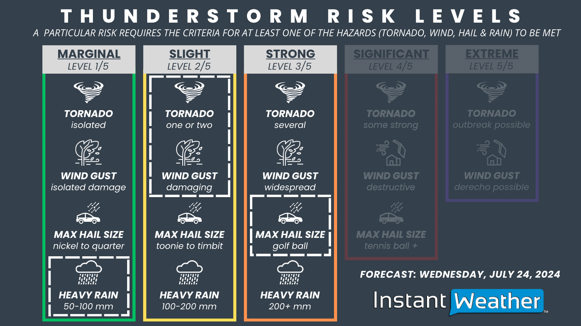
The focus of this severe risk will be on the Ottawa Valley, including Bancroft, Barry’s Bay, Smiths Falls, Renfrew, and the City of Ottawa. This is where we have a 'strong' (level 3) severe risk driven by the potential for large hail up to the size of golf balls. One or two tornadoes and damaging wind gusts are also possible with any storms that develop in this area.
The rest of Eastern Ontario, including Brockville, Kingston, Peterborough, and regions around Lake Simcoe, have a 'slight' (level 2) severe risk. Hail up to the size of toonies, damaging wind gusts, and heavy rainfall are possible threats. An isolated tornado is possible, but the strongest tornado risk should be contained to the Ottawa Valley.
For regions east of Georgian Bay into the Greater Toronto Area, there is a 'marginal' (level 1) severe risk. We don’t expect widespread severe weather here, but a few storms could bring isolated strong wind gusts and quarter-sized hail.
We will be closely following this threat and will post an updated forecast if there are any significant changes in the model data.


