Snow Squalls Take Aim at London, Barrie and Northern GTA on Sunday With Up to 25-50cm of Snow Possible
/
NOTE: YOU CAN CLICK ON THE MAP TO OPEN A ZOOMABLE IMAGE
We enjoyed a brief break from the wintry weather on Saturday as temperatures soared into the double digits across much of Southern Ontario. The exception was Eastern Ontario, where the Ottawa Valley dealt with hours of freezing rain.
But that warm spell is going to be short-lived. Cooler air returns overnight into Sunday, and temperatures will slide back below the freezing mark. Once that happens, the lake effect snow machine will fire up again for the next couple of days.
And no, it isn’t déjà vu. The target zone for this round of squalls will look very similar to last week’s event, but the focus shifts slightly east. That puts areas like London, Barrie and even the Northern GTA, including York Region, in line to be hit hard.
By the time the squalls wind down on Monday, the hardest hit spots could be digging out from more than 25cm, with the potential for very localized pockets of 50cm.
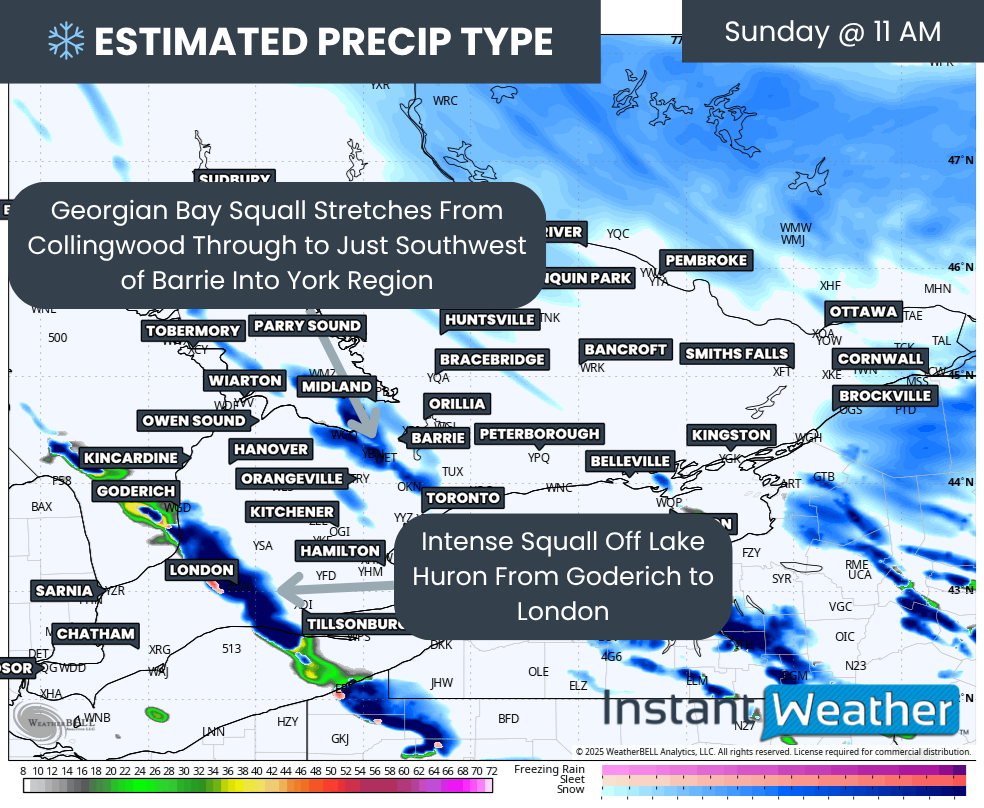
PRECIP TYPE - MAP FROM WEATHERBELL
We expect the snow squall activity to begin ramping up late Sunday morning. As temperatures fall, lake effect rain bands will flip over to snow off the southeast shoreline of Lake Huron and Georgian Bay.
While the changeover happens in the morning, ground temperatures may stay just above freezing for several hours. This means the first few hours of snow could melt on contact. Accumulation will start later in the day once temperatures reach the freezing mark.
Even before the snow begins to stick, visibility will drop quickly. Those in the affected areas should expect sudden whiteouts and dangerous driving conditions.
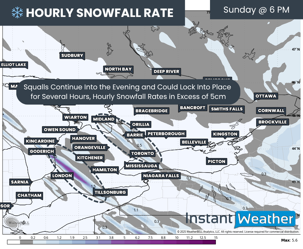
Hourly snowfall rate (cm) - MAP FROM WEATHERBELL
By the dinner hour, the squalls will become much more organized. Snowfall rates from the Lake Huron band could rise to 5cm per hour. This main band is expected to extend from Lake Huron through Goderich and southern Huron County into the London region.
Additional squall activity will form southeast of Georgian Bay, running from the shoreline through Barrie and Angus and into Newmarket and Durham. This band looks weaker than the Lake Huron squall at first, but could still deliver rates of 2 to 4cm per hour.
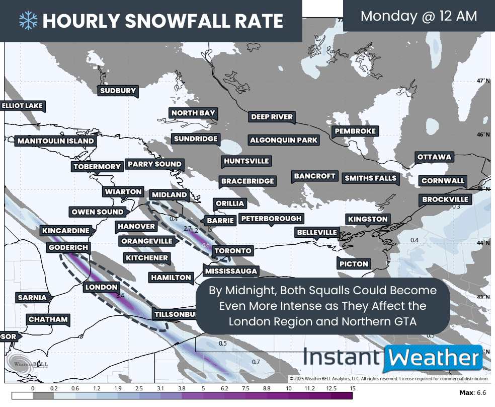
Hourly snowfall rate (cm) - MAP FROM WEATHERBELL
The worst conditions are likely around midnight. The Lake Huron band is expected to lock onto London, bringing intense snow and rapid accumulation of 6 to 8cm per hour.
The Georgian Bay squall will also strengthen, sliding south of Barrie and focusing on Angus, Bradford and Newmarket. Some signals show it reaching into the Eastern GTA, including Scarborough, Ajax and Oshawa.
These squalls should remain mostly stationary overnight, although minor drifting is possible. As temperatures fall several degrees below freezing, expect snow to pile up quickly.
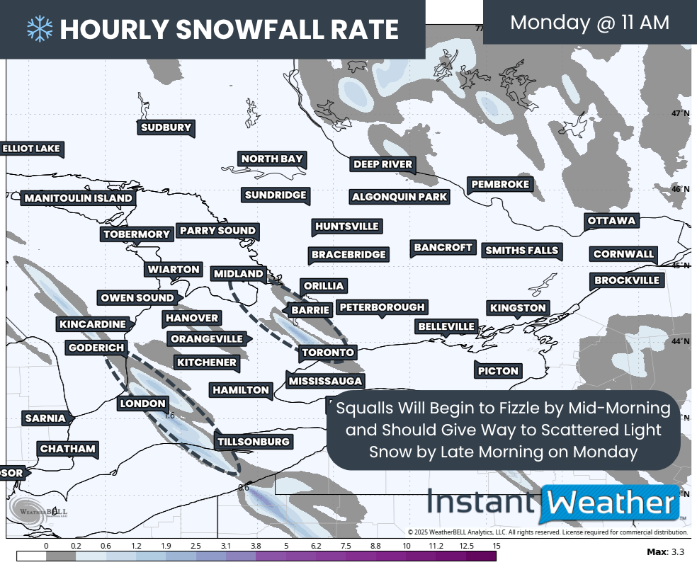
Hourly snowfall rate (cm) - MAP FROM WEATHERBELL
By mid-morning Monday, the bands will begin to weaken as winds shift more westerly. Some lake effect flurries could linger east of Lake Huron into Grey Bruce, but they are not expected to be very organized. Everything should taper off by late Monday.
NOTE: YOU CAN CLICK ON THE MAP TO OPEN A ZOOMABLE IMAGE
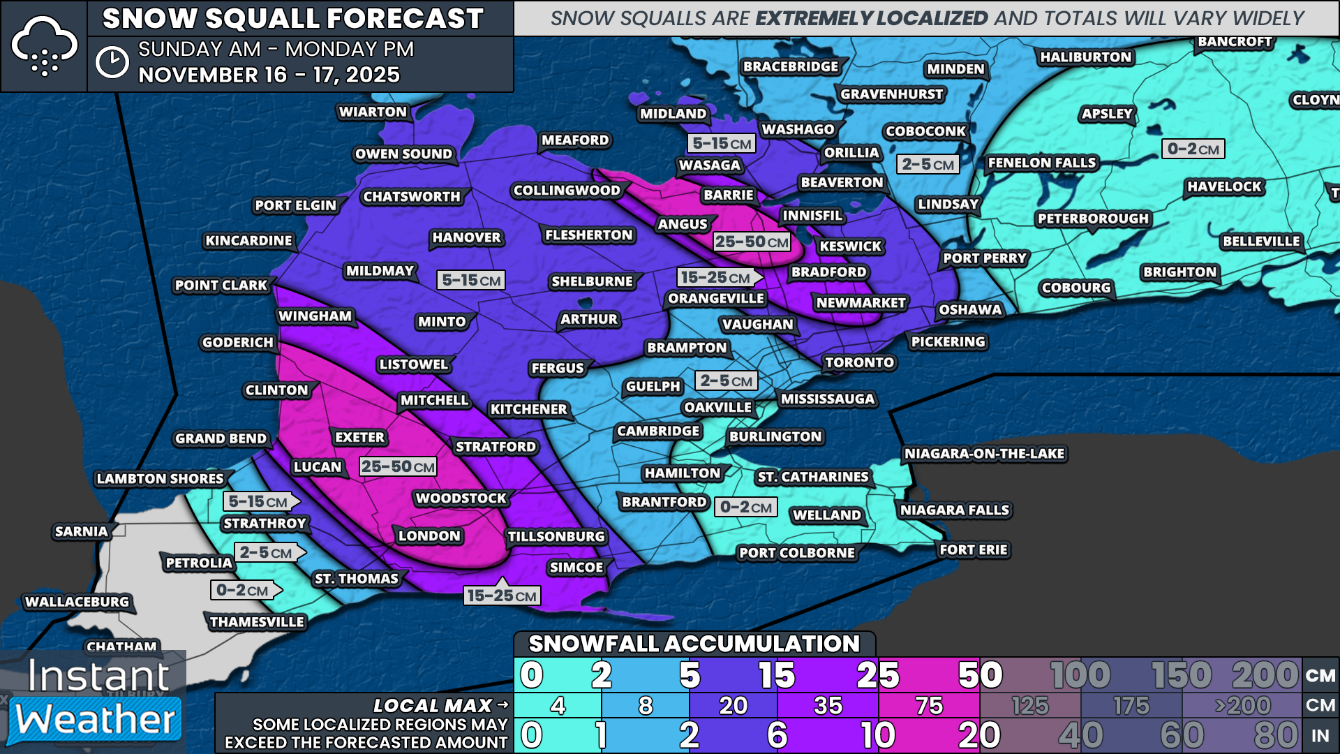
Snow squall forecasting always comes with big caveats. The bands are extremely narrow, which means the difference between 50cm and almost nothing can be only a few dozen kilometres.
This is why we provide a broad range. They help capture that uncertainty, but they are not a guarantee. With this event, the bands appear very intense but also very narrow, which means gradients will be sharp.
Based on the latest data, we expect the hardest hit areas from the Lake Huron squall to include Goderich, Clinton, Lucan, Exeter, Mitchell and London. Snowfall totals here could range from 25 to 50cm, with the chance that someone ends up over 50cm in a very localized spot.
Surrounding regions, including Grand Bend, Tillsonburg, Stratford, Wingham, and Point Clark, could see 15 to 25cm.
Further east into Grey Bruce and Dufferin County, we are expecting 5 to 15cm mainly on Monday as the lake effect shifts northward.
The Georgian Bay band looks even narrower than the Lake Huron band. A small corridor stretching from Collingwood through Angus and into Innisfil could see 25 to 35cm, with a chance of 50cm if the band really intensifies.
The City of Barrie is right on the edge. A small shift north or south would bring very different results. For now, the highest totals look likely in the south end of the city with 15 to 30cm. The north end may be closer to 10 to 20cm.
Substantial totals may also extend into the Northern GTA, including Bradford, Newmarket and Aurora. Totals along the Highway 400 and 404 corridor could range from 15 to 30cm.
Across the east end of Toronto and Durham, including Ajax, Pickering and Oshawa, occasional heavy bursts may bring 5 to 10cm.
The rest of Southern Ontario should see less than 5cm of snow by Monday from the lake effect.