Boxing Day Winter Storm Poised to Deliver Ice Storm Risk and Heavy Snow to Southern Ontario on Friday
/
NOTE: YOU CAN CLICK ON THE MAP TO OPEN A ZOOMABLE IMAGE
With Christmas now behind us, the focus turns to the final stretch of 2025 as we approach New Year’s next Thursday. And it’s looking like the last seven days of the year will be anything but quiet when it comes to the weather across Southern Ontario.
That active pattern becomes clear very quickly with a looming Boxing Day winter storm expected to bring a messy mix of precipitation. Some areas will see periods of heavy snowfall, while others could be dealing with a potentially damaging ice storm with prolonged freezing rain through much of the day.
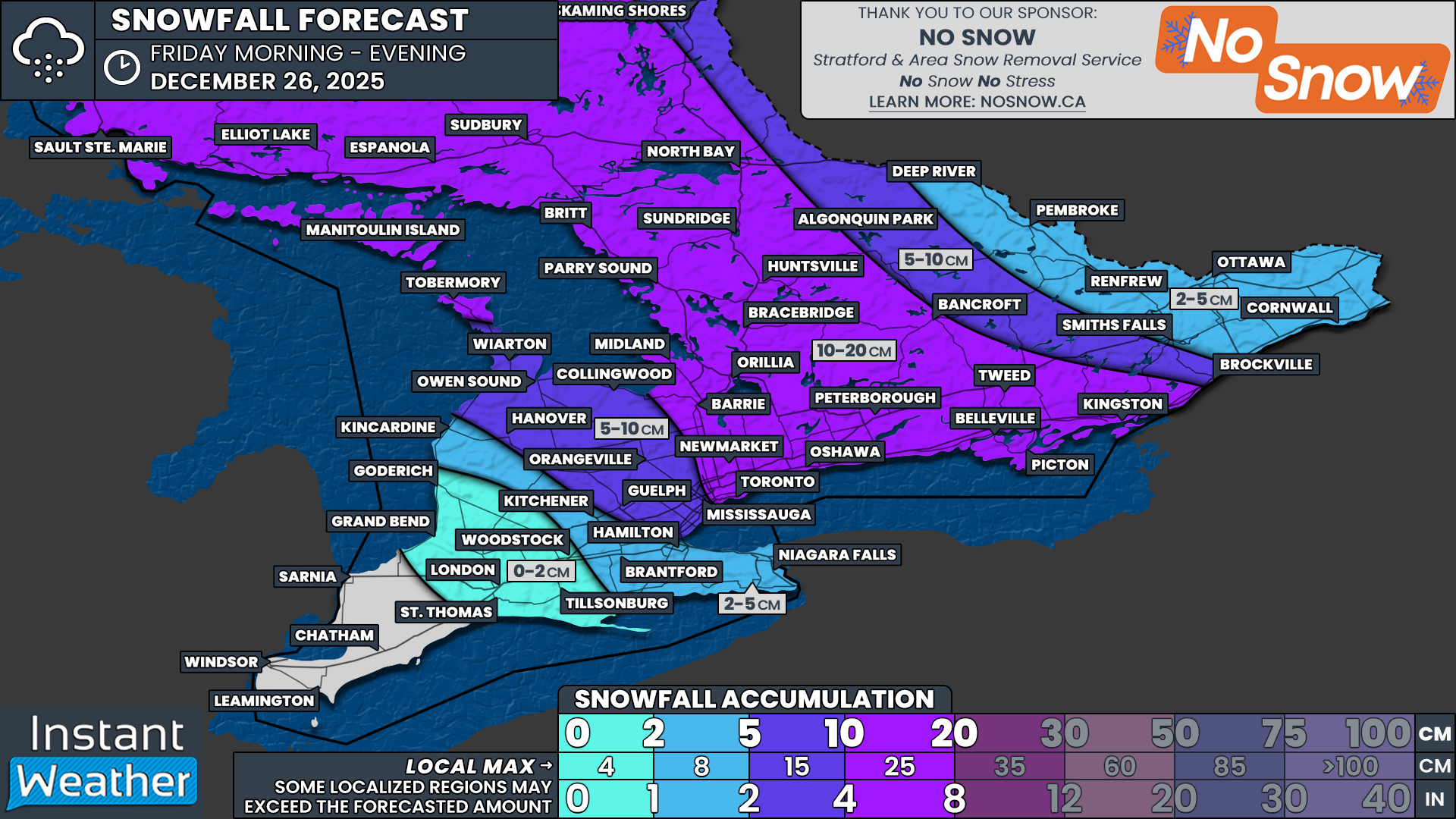
For much of Central Ontario, along with parts of the Golden Horseshoe and into portions of Southeastern Ontario, the primary concern will be snowfall. Widespread totals in the 10 to 20 cm range are possible by the end of Friday. The Ottawa Valley is expected to remain on the lower end, generally staying under the 10 cm mark.
The forecast becomes more complicated through Southwestern Ontario, extending through Hamilton and into the Niagara Region. Here, a mix of snow and ice pellets is expected, which will limit snowfall totals but still create hazardous travel conditions.
The freezing rain risk has shifted slightly northward in the latest model guidance, as warmer air aloft is now expected to push deeper into Southern Ontario than earlier projections suggested. This places the Sarnia to London corridor in the bullseye for the highest ice accretion. Freezing rain totals of 10 to 15 mm are possible, which could result in significant power outages and very icy road conditions.
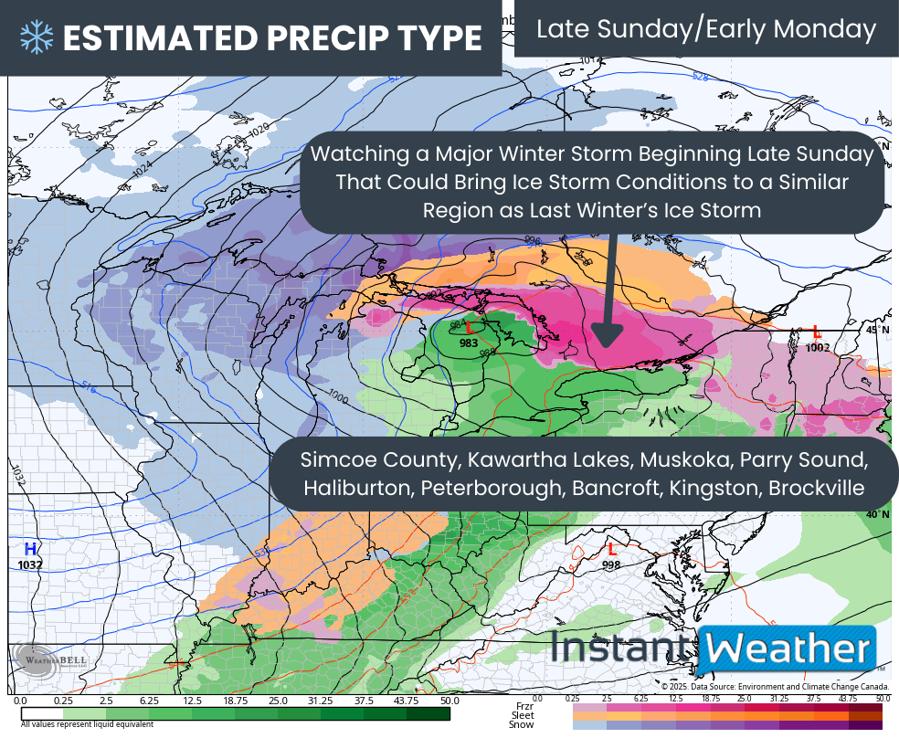
Beyond Friday, attention is already turning to another slow-moving system expected to arrive Sunday and linger into Monday. This system appears to have access to much more moisture compared to Friday’s storm, raising the concern for a prolonged period of freezing rain that could last anywhere from 12 to 24 hours.
What adds to the concern is that current model guidance is focusing this next threat over parts of Central and Eastern Ontario, the same areas that were hardest hit by last winter’s major ice storm. There is still uncertainty with the exact track, and it could shift north or south, but it is something we are watching very closely.
PRECIP TYPE - MAP FROM WEATHERBELL
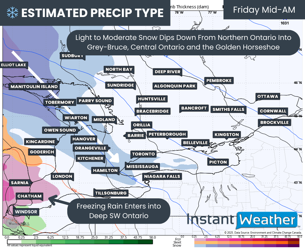
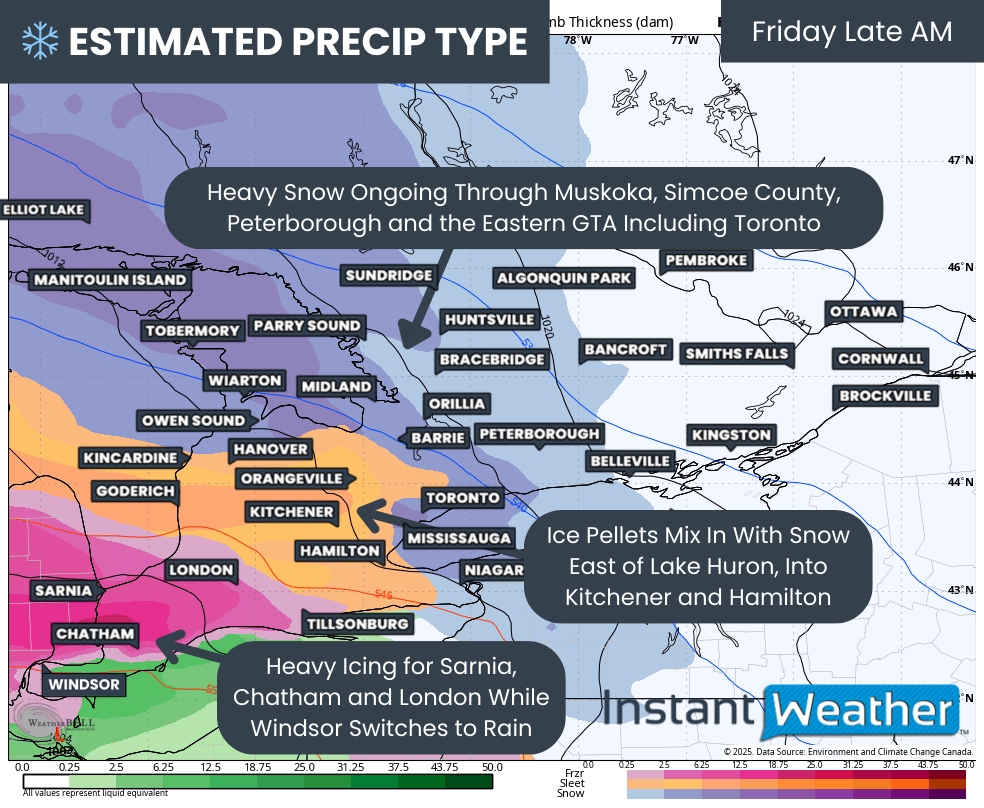
Before we get ahead of ourselves, the immediate focus remains on Friday’s storm. Precipitation is expected to begin during the early to mid-morning hours as bands move in from the west. Light to moderate snow will spread into Grey-Bruce, Simcoe County, Muskoka and the GTA during this time.
For Windsor, Chatham and Sarnia, light freezing rain is expected to begin by mid-morning. Precipitation may be somewhat scattered at first but will steadily increase in coverage and intensity as the morning progresses.
PRECIP TYPE - MAP FROM WEATHERBELL
By late morning, the worst conditions should be underway, with heavy icing ongoing around Chatham, Sarnia and London. Travel conditions in these areas are expected to deteriorate quickly.
Further north and east, heavy snow will be the main concern across Muskoka, Simcoe County, Peterborough and the eastern GTA, including the City of Toronto.
Between the freezing rain to the southwest and the heavy snow to the north and east, a corridor of ice pellets is expected to develop from the Lake Huron shoreline through Kitchener and into Hamilton.
PRECIP TYPE - MAP FROM WEATHERBELL
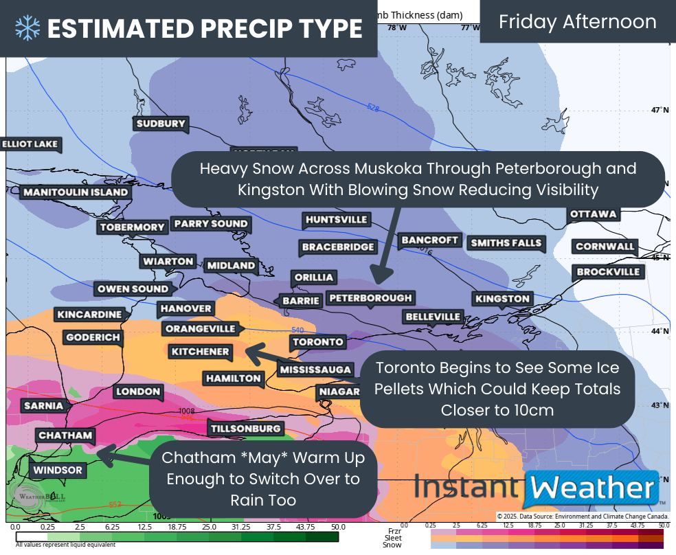
Poor conditions will persist into Friday afternoon, with steady snowfall continuing across Central Ontario into Kingston. Wind gusts approaching 40 km/h may lead to localized blowing snow, further reducing visibility at times.
The ice pellet zone may also push further into the GTA, with Toronto potentially switching over to ice pellets for a time. This would limit snowfall totals and keep them closer to the 10 cm range.
Sarnia and London are expected to remain locked into freezing rain through much of the afternoon. There may be some hope for the Chatham area, where temperatures could briefly rise just above freezing and allow a changeover to rain by mid-afternoon. However, this is right on the line and could still go either way. Windsor and Leamington are expected to remain solidly in the rain zone.
PRECIP TYPE - MAP FROM WEATHERBELL
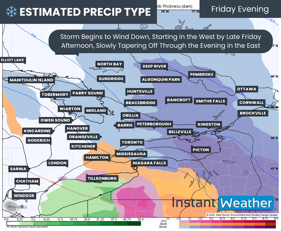
The system is expected to gradually wind down later Friday afternoon and into the early evening. Precipitation will taper off first across western areas, then slowly come to an end across the Golden Horseshoe and Eastern Ontario by late evening.
NOTE: YOU CAN CLICK ON THE MAP TO OPEN A ZOOMABLE IMAGE
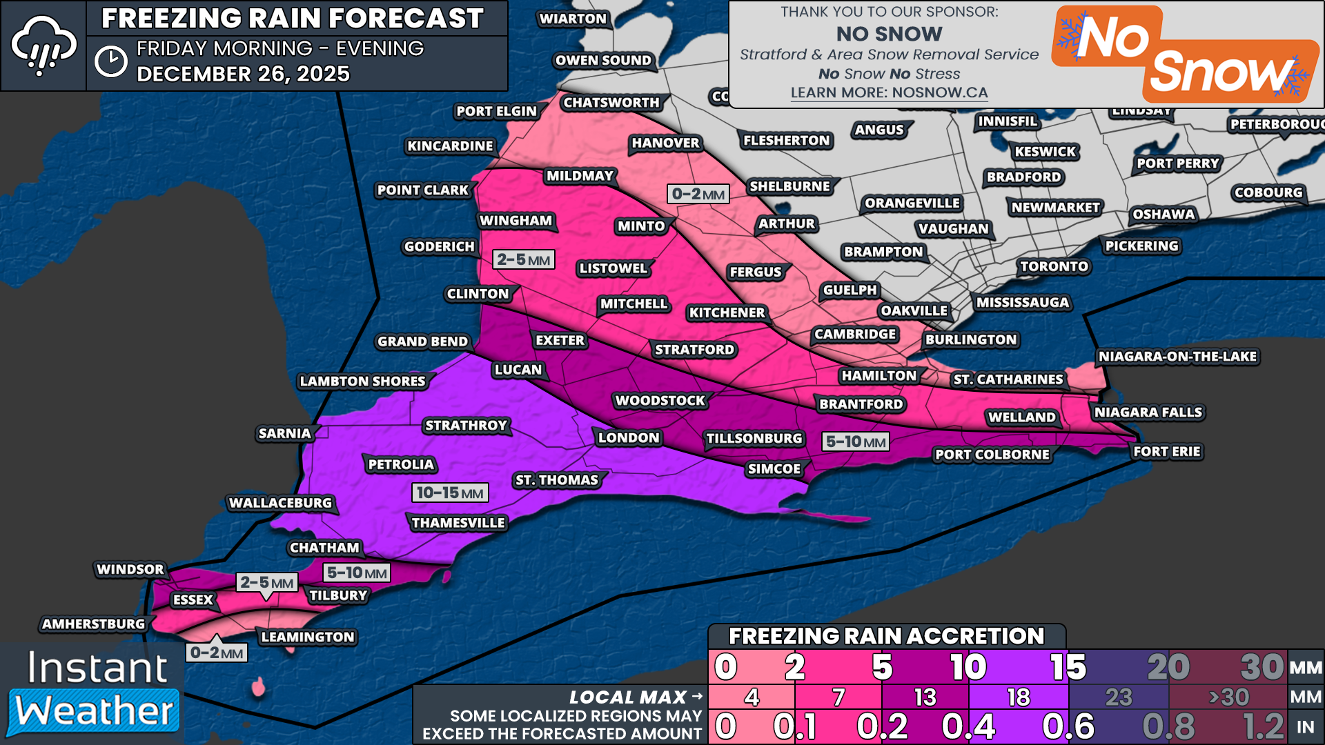
Based on the latest data, the highest ice storm concern has been focused on the Sarnia, Lambton, Middlesex and London corridor. While there is still some disagreement on exact intensity, the potential exists for ice accretion exceeding 10 mm, with localized amounts approaching 15 mm.
Communities included in this higher risk zone include Wallaceburg, Sarnia, Petrolia, Thamesville, Lambton Shores, Grand Bend, St. Thomas and London.
Across Essex County, the highest ice accretion is expected in the northern portions of the county, including Windsor and Tilbury. These areas could see 5 to 10 mm of ice before a changeover to rain. Closer to the Lake Erie shoreline, including Leamington, icing should be minimal, generally under 2 mm, as temperatures rise above freezing more quickly.
Further north, freezing rain amounts will be reduced as ice pellets dominate initially, with freezing rain gradually mixing in later. Locations such as Lucan, Exeter, Woodstock, Tillsonburg, Simcoe, Port Colborne and Fort Erie could see a faster transition to freezing rain, with 5 to 10 mm of ice possible following a few hours of ice pellets.
For Huron and Perth counties, including Kitchener, Brantford and Niagara Falls, ice pellets are expected to linger longer. This will limit freezing rain to only a few hours near the end of the storm, with ice accretion generally in the 2 to 5 mm range. Less than 2 mm of icing is expected for Hamilton, Guelph and southern Grey-Bruce.
NOTE: YOU CAN CLICK ON THE MAP TO OPEN A ZOOMABLE IMAGE

On the snowfall side of the storm, the highest totals are expected to range from 10 to 20 cm across Northeastern Ontario, down into Central Ontario and parts of Eastern Ontario.
This includes areas such as Sudbury, North Bay, Parry Sound, Muskoka, Simcoe County, York Region, Toronto, Durham Region, the Kawarthas, Peterborough and Kingston.
Lower snowfall totals are expected in the Ottawa Valley, where amounts of 2 to 5 cm are forecast for Ottawa and 5 to 10 cm from Bancroft into Brockville. This is due to the core of the system’s moisture remaining further south.
South of the heaviest snow band, totals will decrease as ice pellets mix in later in the storm. Grey-Bruce, Orangeville, Guelph and the western GTA are currently expected to see 5 to 10 cm, though some model solutions suggest even less if mixing becomes more dominant.
Even lower snowfall totals are expected east of Lake Huron into Hamilton and Niagara, where less than 5 cm is forecast as ice pellets and freezing rain become the primary precipitation types.
PRECIP TYPE - MAP FROM WEATHERBELL
Once this system exits Friday night, Saturday should bring a brief period of calmer weather. However, that break will be short-lived, as another potentially high-impact winter storm is expected to approach as early as Sunday, possibly arriving in multiple waves.
The overall setup supports the potential for a prolonged area of freezing rain that could remain locked in place into Monday. This raises concern for a significant ice storm event, potentially similar in nature to last winter’s devastating storm across Central and Eastern Ontario.
Those same regions are once again in the early bullseye. While there is still time for this forecast to change, this is the type of setup where residents should begin thinking ahead and preparing for the possibility of extended power outages if the scenario does not improve.
We will continue to monitor this closely and will have a more detailed update once we get through Friday’s storm.