All the Seasons in One Weekend for Southern Ontario as Freezing Rain, Thunderstorms and Snow Squalls Line Up
/
NOTE: YOU CAN CLICK ON THE MAP TO OPEN A ZOOMABLE IMAGE
There is really only one way to describe what November has been like across Southern Ontario when it comes to the weather: a roller coaster.
Last weekend brought our first widespread snowfall event of the season. That was quickly followed by intense snow squalls that buried parts of the Lake Huron shoreline with more than 50 cm of snow early this week.
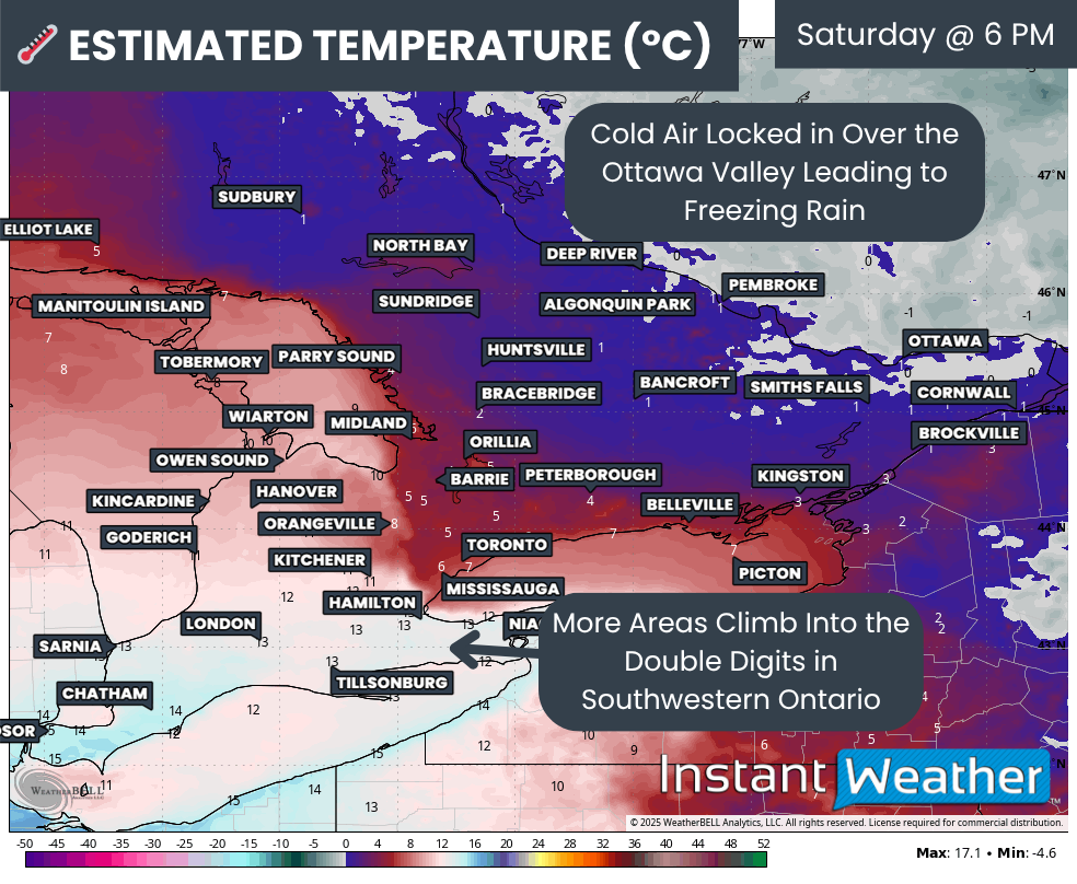
That seasonal whiplash continues this weekend as a clear battle sets up between cold, wintery air and much milder fall-like conditions. Eastern Ontario, especially around the Ottawa Valley, will stay on the cold side with a risk of prolonged freezing rain throughout the day on Saturday.
Southwestern Ontario and the Golden Horseshoe will see a completely different story. Temperatures are set to rise into the double digits, and there is even a risk of thunderstorms on Saturday. Some of the warmest pockets around Windsor could briefly flirt with the 20s for a few hours.
By late Saturday, a sharp cold front will sweep through the region. This will send temperatures plunging again heading into Sunday, settling the battle in favour of the colder air. As this cold push arrives, the lake effect snow machine is expected to roar back to life over both Georgian Bay and Lake Huron.
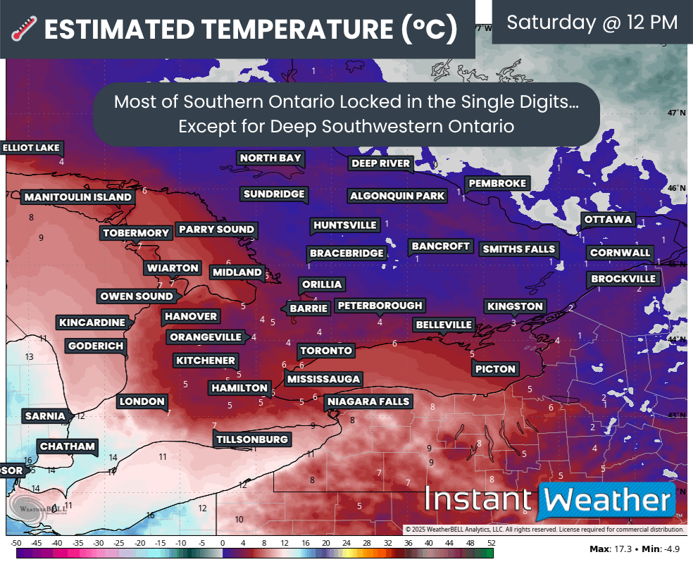
TEMPERATURE - MAP FROM WEATHERBELL
We expect a frosty start to Saturday morning for most of Southern Ontario. Deep Southwestern Ontario will be the main exception as milder air starts to slide in early. Most areas should wake up close to the freezing mark. Deep Southwestern Ontario will already be climbing through the mid single digits.
By noon, Deep Southwestern Ontario should reach the double digits. Further northeast into the rest of Southwestern Ontario, the Golden Horseshoe and parts of Central Ontario, temperatures will range from the low to mid single digits. The Ottawa Valley will remain near the freezing mark well into the afternoon as the surge of mild air stalls just to the southwest.
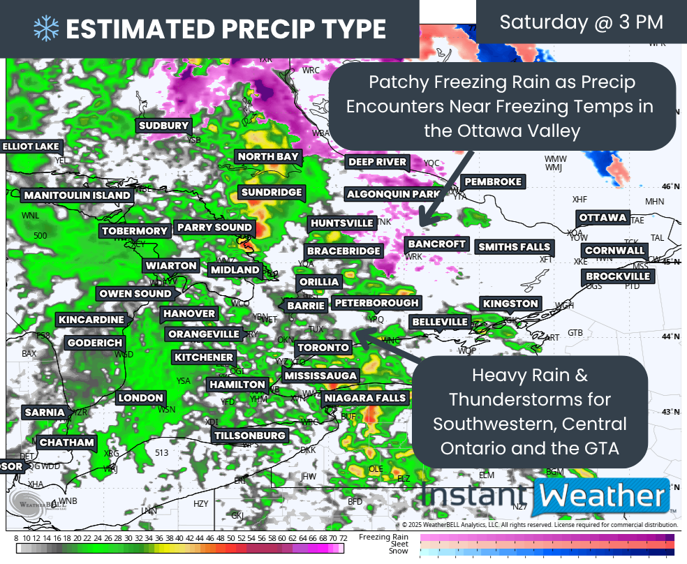
PRECIP TYPE - MAP FROM WEATHERBELL
A developing system will start to spread heavy precipitation into Southern Ontario late Saturday morning or early afternoon. For most areas, temperatures will be warm enough for rain to be the dominant precipitation type. There’s even the risk of a thunderstorm!
Over the Ottawa Valley, however, we expect patchy freezing rain to form as temperatures linger stubbornly near the freezing mark.
Model guidance is not fully aligned on how warm the air will get in that region. Even a small shift of one or two degrees will change how long the freezing rain lasts and how much ice is able to accrete. This is one of the key uncertainties for Saturday.
TEMPERATURE - MAP FROM WEATHERBELL
Through Saturday evening, temperatures will continue climbing across much of Southwestern Ontario. Cities like London, Kitchener and Hamilton are expected to reach the double digits.
One important note is that daytime highs in many areas will actually be reached late in the evening instead of during the normal warmest part of the day!
Meanwhile, that pocket of near-freezing air over the Ottawa Valley is expected to hold on into the evening, which could allow several more hours of freezing rain.
As the system pulls east overnight Saturday, colder air will sweep in behind it. Temperatures will tumble through Sunday morning, switching any lingering precipitation to wet flurries by the time you wake up.
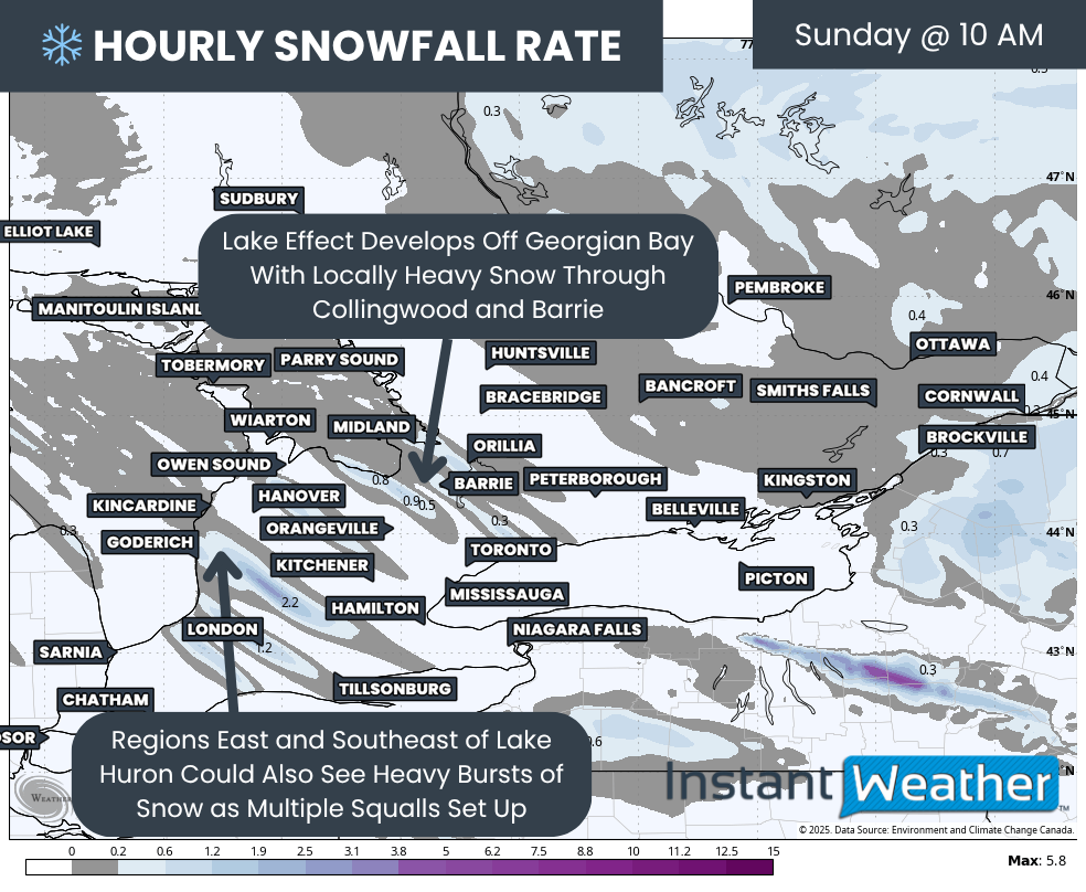
Hourly snowfall rate (cm) - MAP FROM WEATHERBELL
Behind the front, bands of lake effect snow will begin developing off Lake Huron and Georgian Bay early Sunday. These bands look messy and disorganized through much of the day, although localized totals of 10 to 20 cm are possible.
By late Sunday, more focused and intense squalls could form, especially around the London region off Lake Huron. These squalls may continue into Monday and could lead to localized 20+ cm totals.
We will have a more detailed, dedicated lake effect forecast released soon.
NOTE: YOU CAN CLICK ON THE MAP TO OPEN A ZOOMABLE IMAGE
When it comes to freezing rain accretion, there are several variables that could reduce or increase the amount of ice that actually builds up. This is a very temperature-sensitive event.
The heaviest icing is expected directly along the Quebec border and into the Hawkesbury region. Models show the potential for over 10 mm of freezing rain, but it is unclear how much of that will be able to stick. Heavy precipitation rates could limit the amount of ice that accumulates, and temperatures will sit very close to the freezing mark for much of the event.
Given all of this, we are going with a general 5 to 10 mm of icing for the hardest hit areas. If temperatures are even slightly warmer than expected, accretion could end up lower. This is certainly enough to lead to localized power outages and icy roads.
For the City of Ottawa, they sit right on the dividing line between lighter icing and heavy icing. We have placed them in the 2 to 5 mm range, but they could see locally up to 7 mm if the cold air becomes more stubborn than currently forecast.
Outside of the Ottawa Valley, expect minimal icing. Areas such as Bancroft, Cloyne, Perth, Carleton Place and Cornwall may see an hour or two of freezing rain before changing over to rain.