Winter Storm Targets Northern Ontario This Week as Intense Snow Squalls Line Up for Southern Ontario Starting Thursday
/
NOTE: YOU CAN CLICK ON THE MAP TO OPEN A ZOOMABLE IMAGE
A powerful system will sweep through the Great Lakes region this week, bringing a major winter storm to Northern Ontario and setting the stage for a significant snow squall event across Southern Ontario later in the week.
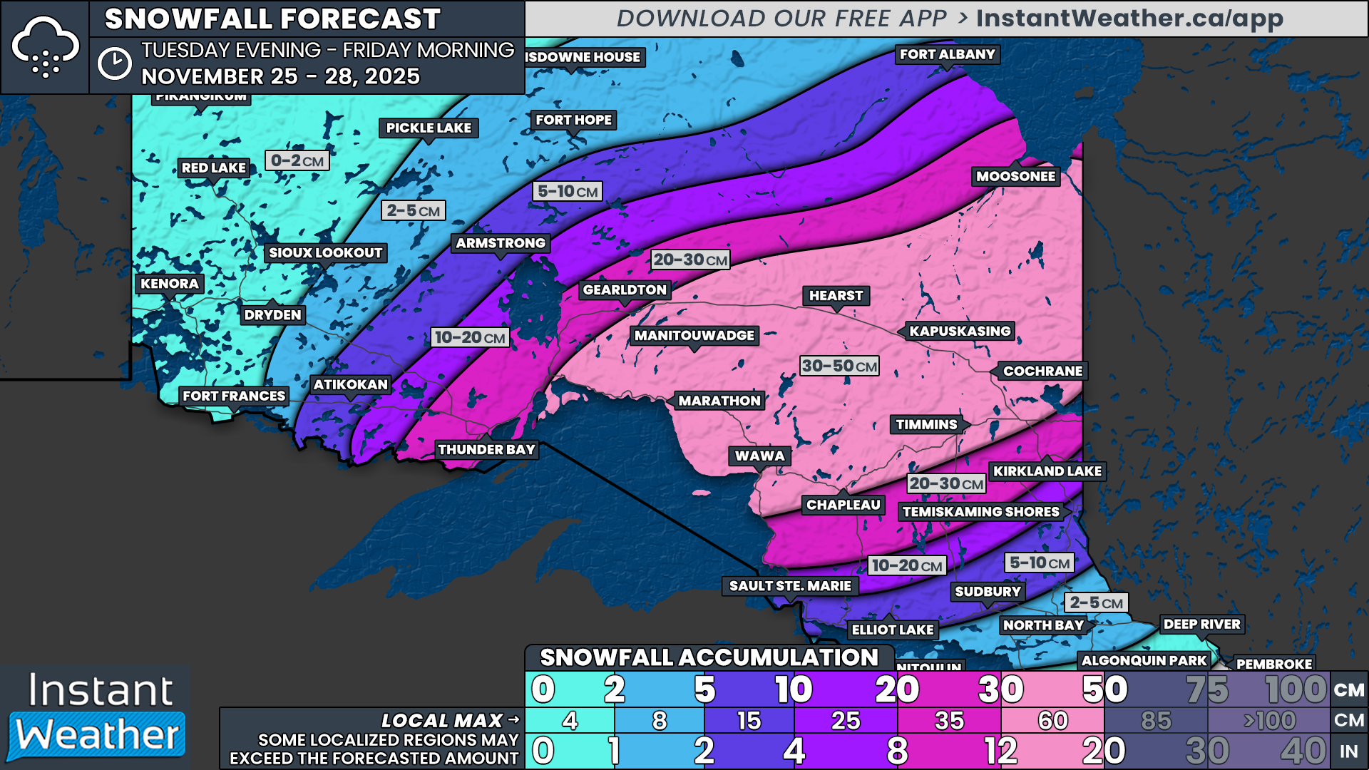
Across Northern Ontario, snowfall will begin to move into regions east of Lake Superior by late Tuesday. Light snow will start from Wawa through Timmins, gradually expanding north and west. Through the overnight hours into Wednesday morning, the system will push into Thunder Bay, Kapuskasing and surrounding communities.
The worst conditions are expected throughout the day on Wednesday. Winds will gust between 40 and 60 km/h, and when combined with heavy snowfall rates, visibility will deteriorate quickly. Blowing snow will be widespread across Northeastern Ontario and conditions may even reach blizzard levels at times.
Treacherous travel conditions will continue into Wednesday night and persist through Thursday morning as the storm deepens. Snowfall intensity will gradually ease later on Thursday, but steady snow will continue as the system stalls over Quebec. This will push long lasting bands of precipitation back into Northeastern Ontario, keeping snow going until early Friday morning.
By the time the storm fully exits, a wide swath of Northeastern Ontario is expected to receive 20 to 50 cm of snow, with localized totals possibly exceeding that. The heaviest totals are expected from Marathon through Kapuskasing, Cochrane, Timmins, and Temiskaming Shores, Wawa, Hearst and Chapleau. Snowfall totals here will range from 30 to 50cm with possibly as much as 60cm in localized pockets.
While Northern Ontario deals with the winter storm, Southern Ontario will be on the warm side of the system on Tuesday and Wednesday. Many areas will flirt with the double digits, especially in Southwestern Ontario. Scattered showers will develop early Tuesday with light rainfall amounts of roughly 5 to 10 mm.
By late Wednesday, though, the pattern begins to shift as cold air wraps in behind the departing system. Temperatures will drop quickly, and any lingering precipitation will change to wet snow by Wednesday evening.
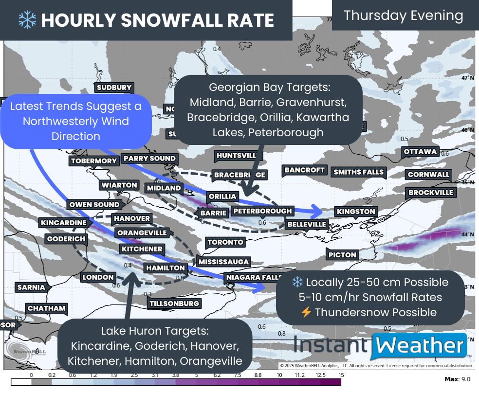
This colder air will set the stage for lake effect snow to fire up. With a westerly wind overnight on Wednesday, snow squalls may begin to develop off Lake Huron and Georgian Bay.
These early bands could bring bursts of heavy snow to Grey Bruce, Parry Sound and Muskoka through Thursday afternoon, although the exact intensity remains uncertain as the higher resolution models are just entering range and showing stronger signals than the medium range guidance.
By late Thursday, winds will shift to a northwest flow. Temperatures will drop further into the negatives and this will allow squalls to strengthen. The Georgian Bay band is expected to sink south into Simcoe County and then extend into Kawartha Lakes and Peterborough.
At the same time, the Lake Huron band will slide south into Huron County and stretch toward Kitchener and the western GTA. Some early guidance even hints that this band could link up with the flow off Lake Superior, which can enhance snowfall rates.
Heading into Friday, it is still too early to give precise band placement. Current thinking suggests the northwest flow will hold through much of the day before winds start easing over the weekend. If that happens, squalls could remain active for an extended period.
While details can still shift, we are beginning to narrow down regions with the highest risk of heavy snowfall starting Thursday morning and continuing into Friday evening. Squalls will shift around at times, so snowfall will not be constant, but those under the core of the bands could see snowfall rates approaching 5 to 10 cm per hour. It will not take long for the snow to accumulate.
At this stage, exact totals are not possible to predict for Southern Ontario. However, some regions could easily see 25 to 50 cm by Friday night, with the potential for higher localized totals once high-resolution data comes into range.
For Lake Huron, our current focus areas include Kincardine, Goderich, Hanover, Kitchener, Hamilton and Orangeville.
For Georgian Bay, our primary targets include Midland, Barrie, Gravenhurst, Bracebridge, Orillia, Kawartha Lakes and Peterborough.
Anyone living in or near these regions should be prepared for dangerous travel conditions beginning Thursday. School bus cancellations are likely for some regions, and road closures are possible if squalls remain intense or stationary.


