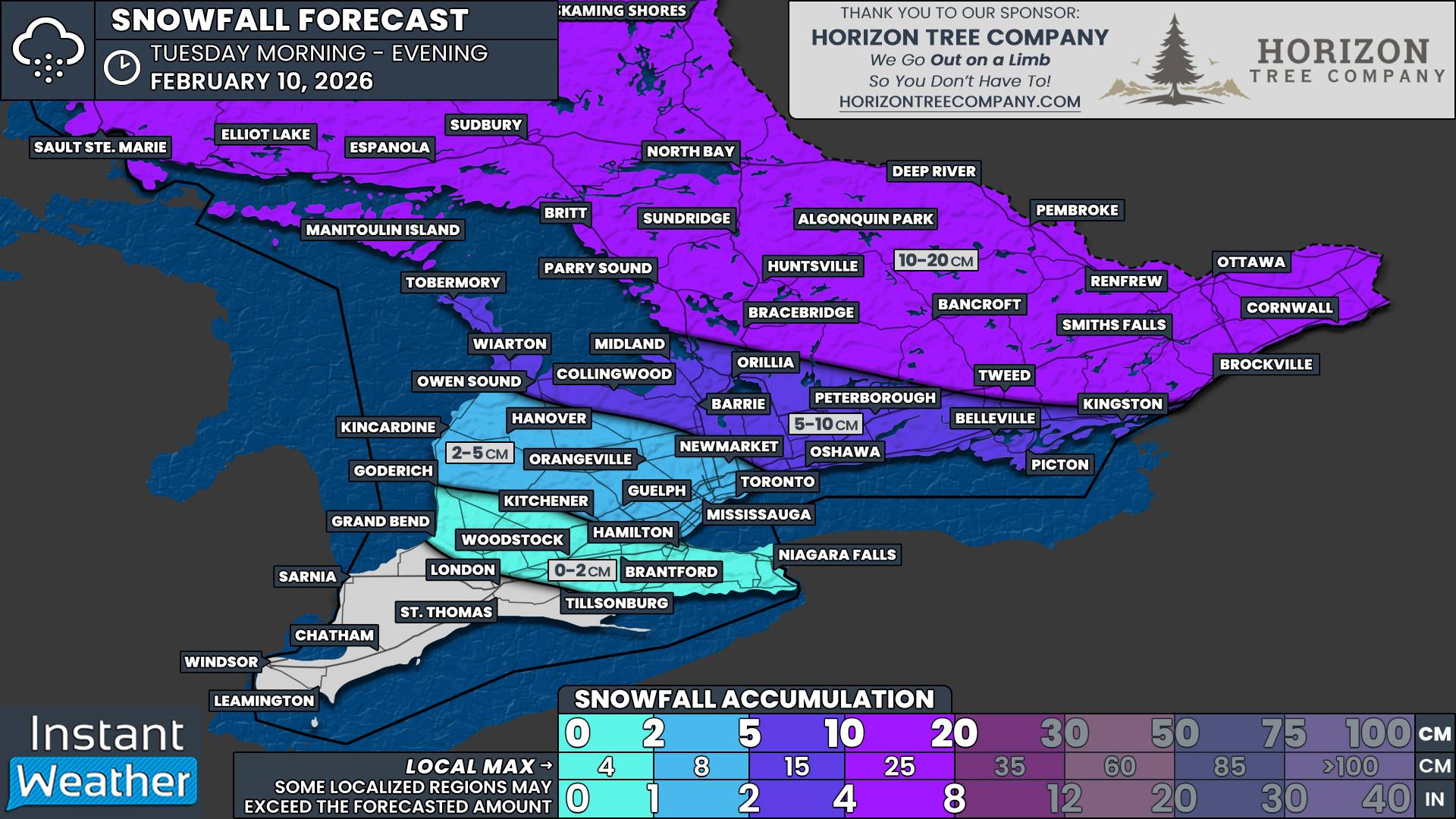
25-40cm of Snow Possible Around Toronto on Sunday as Widespread Snowstorm Threatens Travel Across Southern Ontario

Enter to Win a 7-Night Cruise for 2 with Celebrity Cruises, Including Airfare - Select Patricia Bootsma as your travel consultant

NOTE: YOU CAN CLICK ON THE MAP TO OPEN A ZOOMABLE IMAGE

An expansive and high-impact winter storm is currently bearing down on a large portion of the United States this weekend, bringing widespread heavy snowfall and areas of crippling freezing rain to parts of the Southeast and the Northeastern US. This is a powerful and dynamic system that is already causing significant concern south of the border, with dangerous travel conditions, power outage risks and major disruptions expected in many states.

Southern Ontario will not be spared entirely from this storm. While we will avoid the worst of the freezing rain and blizzard conditions seen farther south, we are firmly in line to be clipped by the northwestern edge of this system on Sunday. That will be enough to deliver a widespread and impactful snowstorm across much of the region.

The axis of heaviest snowfall is expected to stretch from near the Lake Erie shoreline, through the Golden Horseshoe, and eastward into Eastern Ontario. Travel impacts are likely to be significant, especially as the most intense snowfall rates arrive during the afternoon and evening hours on Sunday, a time when roads are typically busiest. Although thankfully on the weekend, which should help keep traffic volumes lower compared to a workday.

For many areas, general snowfall totals are expected to range between 15 and 25cm. This includes a broad zone covering Windsor, London, Kitchener, Kingston, Peterborough and Ottawa. However, snowfall amounts will not be uniform, and some regions will see considerably higher totals due to lake enhancement and mesoscale banding features.

The greatest concern continues to focus on the Golden Horseshoe and the Lake Ontario shoreline, where lake enhancement is expected to play a major role. In these areas, snowfall totals are likely to exceed 25cm, with some locations pushing well beyond that threshold by the time the snow tapers off late Sunday night.

There is growing confidence in the development of a persistent and narrow band of lake effect snow becoming embedded within the broader system snowfall. This feature is expected to impact parts of the Greater Toronto Area and the northwestern and western shoreline of Lake Ontario. When lake effect bands become embedded within a large-scale storm like this, snowfall rates can intensify dramatically over a very small area.

This creates an unusual and high-risk setup where the most impressive snowfall totals of the entire event may end up falling over the most densely populated portion of Southern Ontario. In some neighbourhoods, it cannot be ruled out that total snowfall may approach or even exceed 40cm.

If that scenario materializes, it would place this event among the more significant snowfall events Toronto has seen in recent memory. At the same time, it is important to stress that totals will vary sharply over short distances depending on where this narrow band ultimately sets up.

Snow falling at this intensity, especially over a relatively short 12 to 16-hour window, is likely to cause major issues across the urban core of the Greater Toronto Area. Rapid accumulation during the afternoon and evening could overwhelm road crews, making it difficult to keep up with clearing operations.

It is very possible that some major routes could see closures if conditions deteriorate quickly, including portions of the DVP, the Gardiner Expressway and sections of the 400 series highways.

Although the snow is expected to gradually wind down overnight into Monday morning, impacts will linger well beyond the end of the snowfall. The Monday morning commute is likely to be heavily affected, with many roads still uncleared or partially cleared. This increases the likelihood of school bus cancellations and even potential school closures across the hardest hit regions.

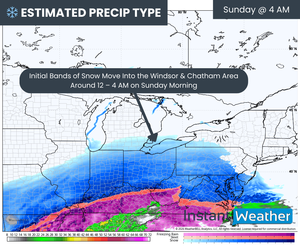
The timeline for this storm begins during the overnight hours into early Sunday morning. Initial bands of light to moderate snow are expected to move into Deep Southwestern Ontario first.

Areas like Windsor and Chatham should see snow begin around 2 to 4 AM, with coverage and intensity increasing steadily through the morning hours.

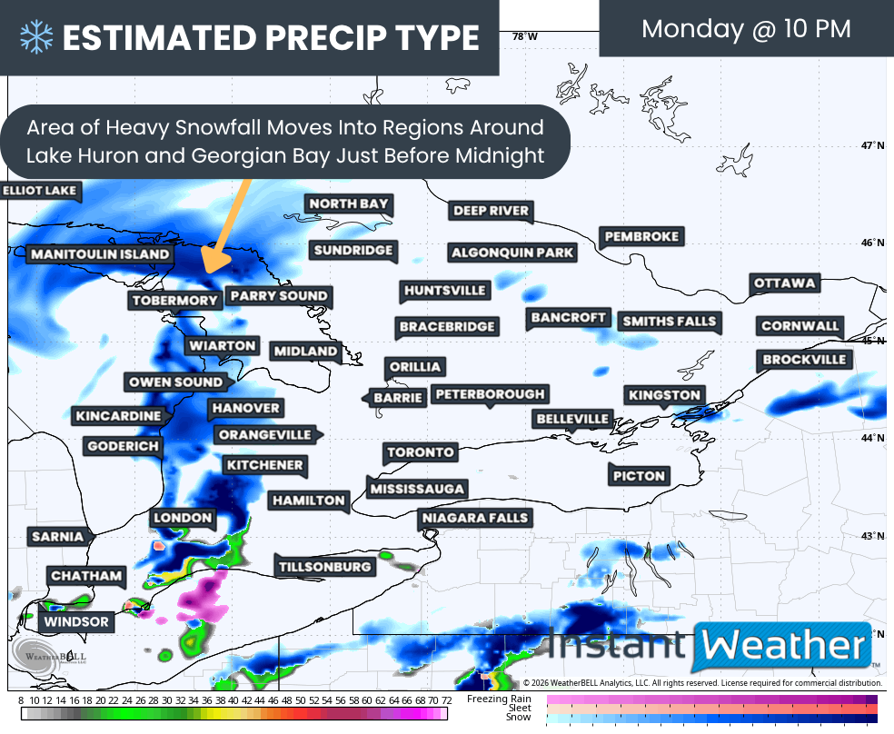
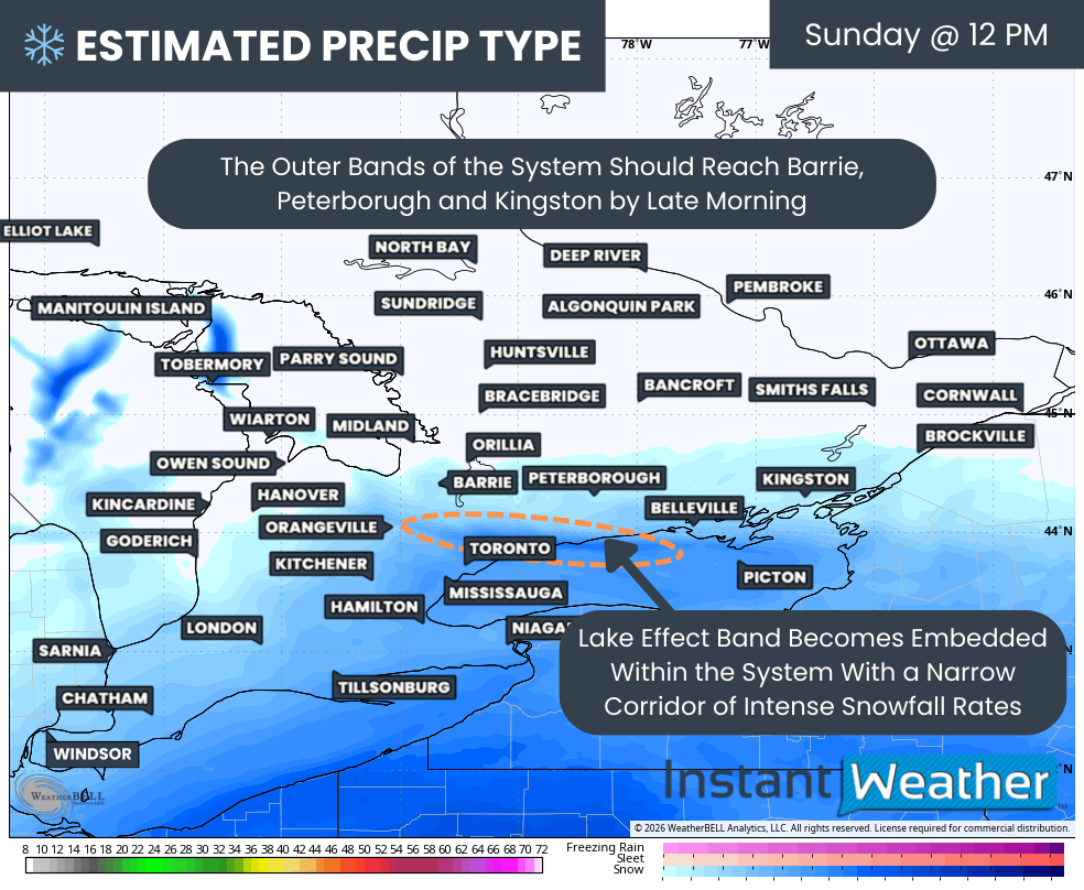
PRECIP TYPE - MAP FROM WEATHERBELL

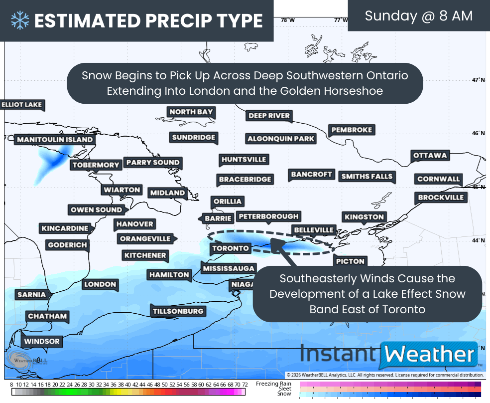
As the morning progresses, the snow shield will expand northeastward, reaching London, Hamilton, Kitchener and the Niagara region by late morning. Snow may start off relatively light in these areas, but conditions will deteriorate as snowfall rates increase heading into the afternoon.

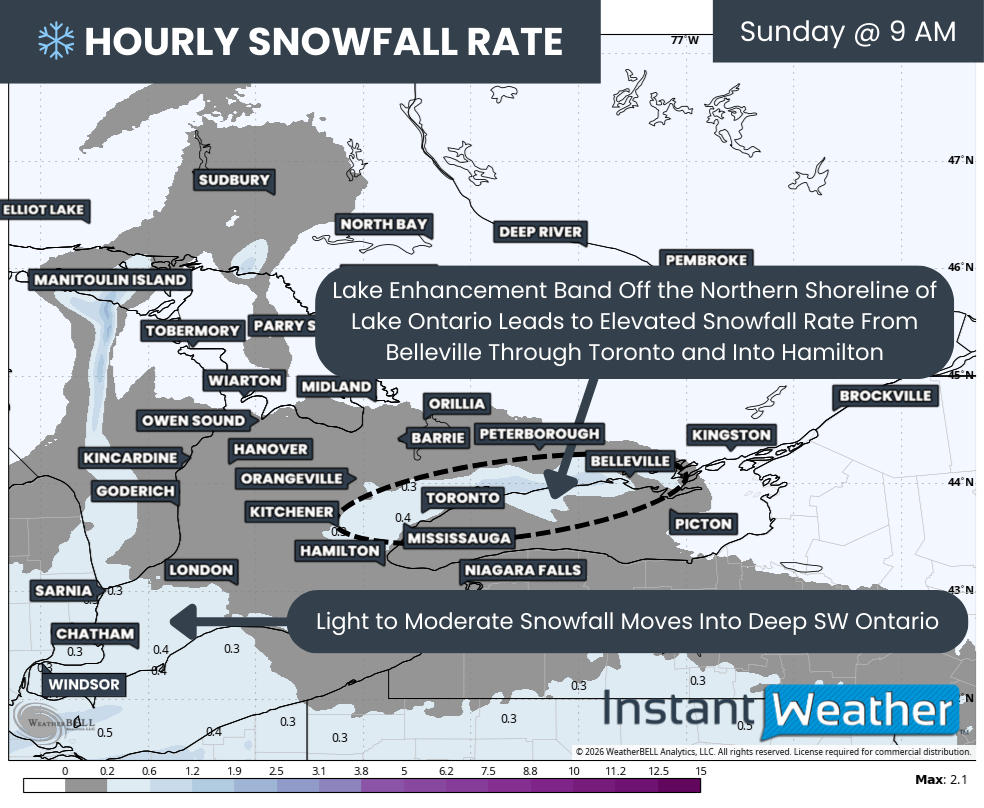
At the same time, a notable lake-driven feature is expected to develop over Lake Ontario. This feature may look like a “snow snake,” a narrow but intense band of lake effect snow that forms when cold Arctic air interacts with an unusual southeasterly wind flow. This is not a common setup, as southeasterly flows are typically associated with warmer air rather than when cold air is pushed in from the north or west.

This band is expected to first impact the northwestern shoreline of Lake Ontario, including portions of the Highway 401 corridor between Cobourg and Oshawa. Heavy snowfall rates are possible within this band even before the broader system snow arrives. In a short period of time, this could lay down 10 to 20cm of snow before noon in some areas.

PRECIP TYPE - MAP FROM WEATHERBELL

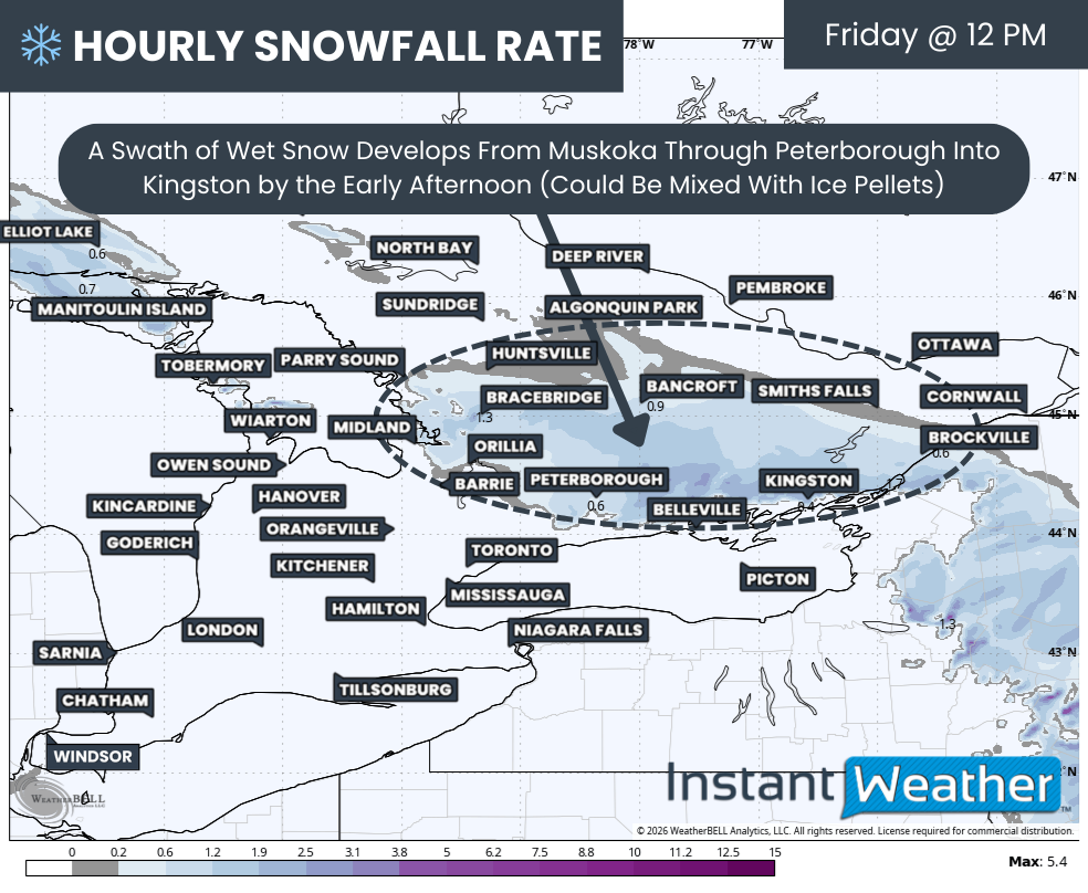
By early afternoon, snowfall will ramp up significantly across much of Southern Ontario. More widespread, steady and heavy snow will overspread the Lake Erie shoreline and the Golden Horseshoe. The outer edge of the precipitation shield should reach areas from Barrie through Peterborough and into Kingston between roughly 11 AM and 1 PM.

One of the most critical elements of this forecast is how the system snow interacts with the lake effect band. As the main storm moves in, it is expected to absorb this lake effect band, but the band does not disappear. Instead, it continues as an embedded zone of enhanced snowfall, focused primarily on the eastern GTA, including Oshawa, Ajax and Whitby during the early afternoon. These areas will benefit from an added moisture source, resulting in higher snowfall rates than surrounding regions.

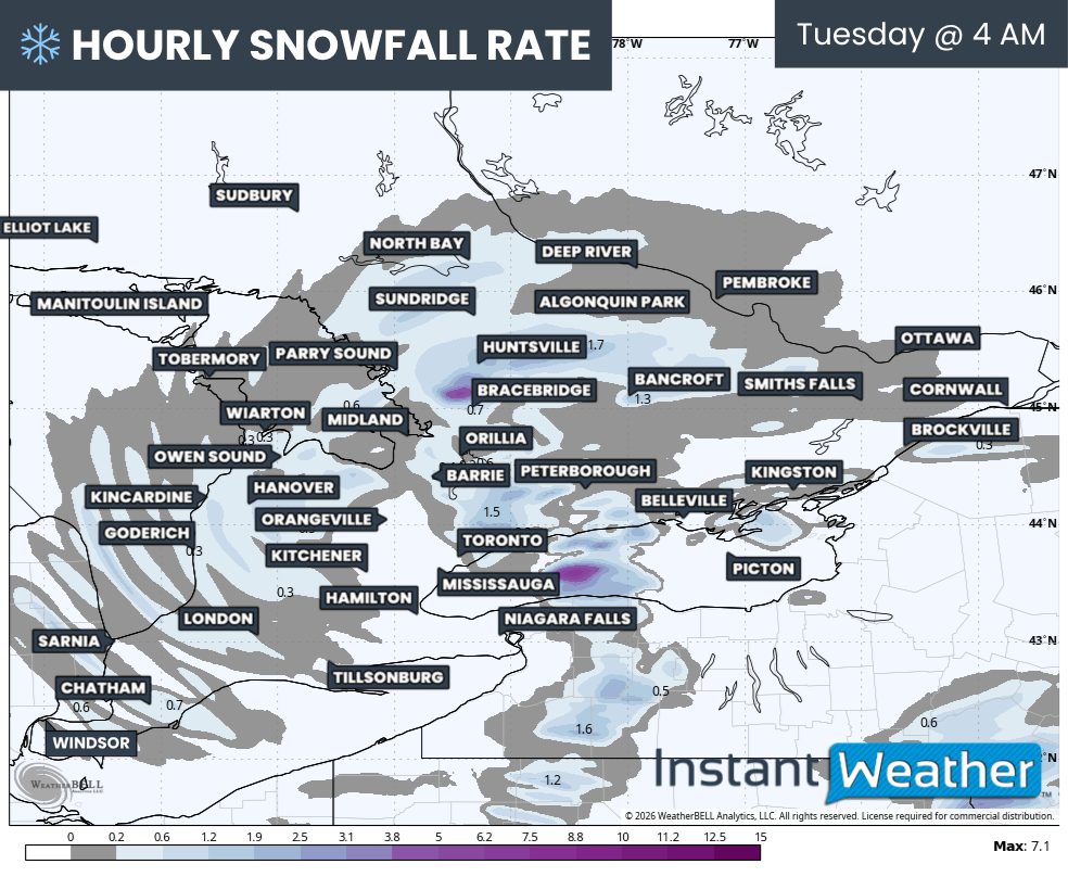
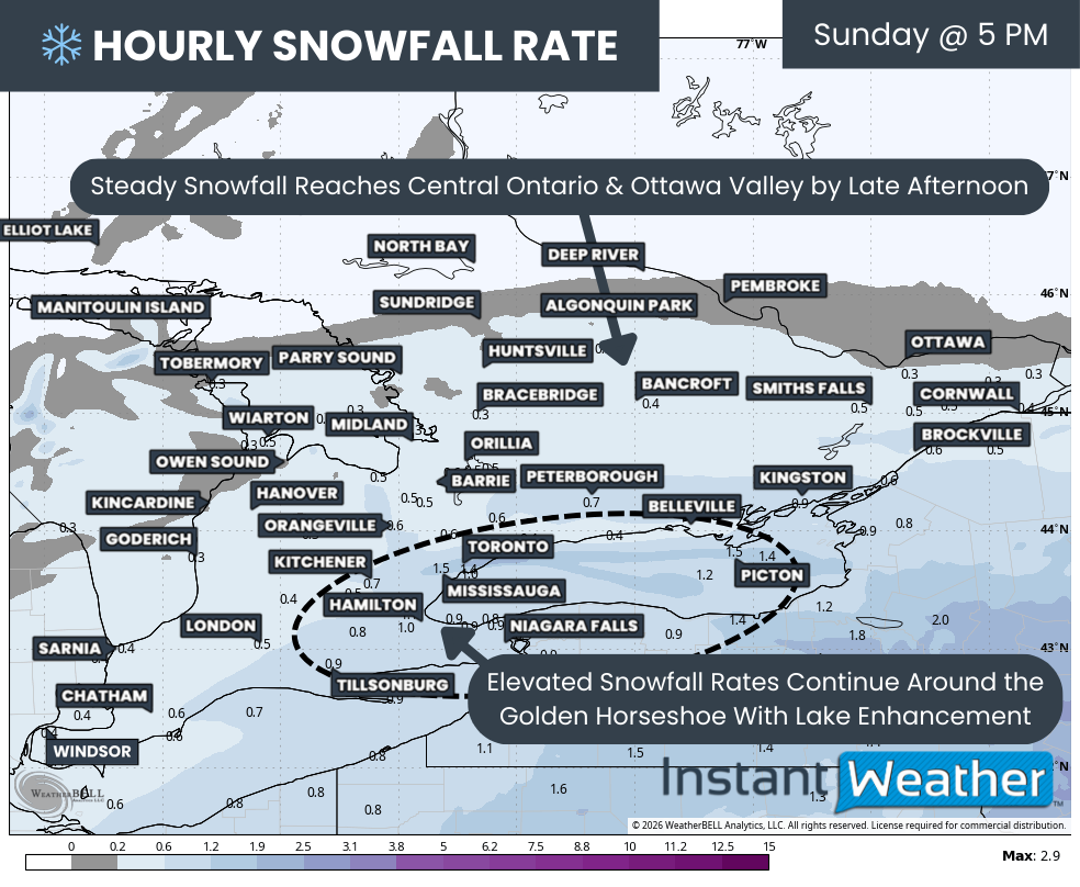
Hourly snowfall rates (cm) - MAP FROM WEATHERBELL

Snow will continue spreading northeast through the afternoon, eventually reaching Central Ontario and the Ottawa Valley by the mid to late afternoon. Similar to elsewhere, snow may begin on the lighter side but is expected to intensify into the evening hours for Eastern Ontario.

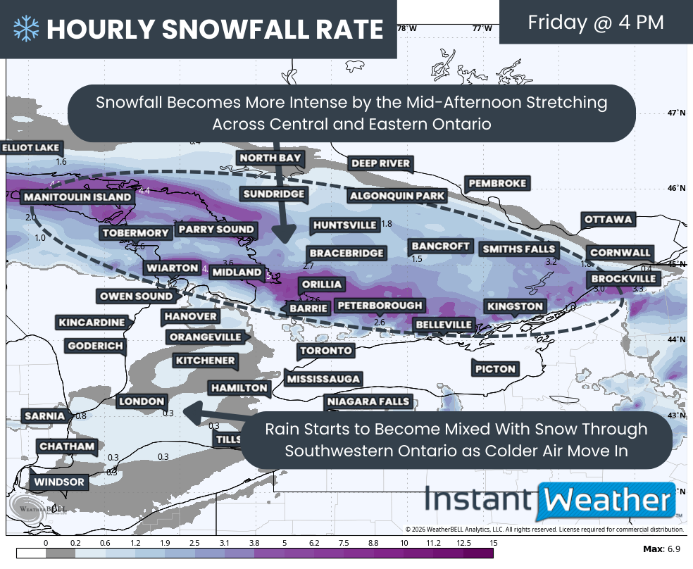
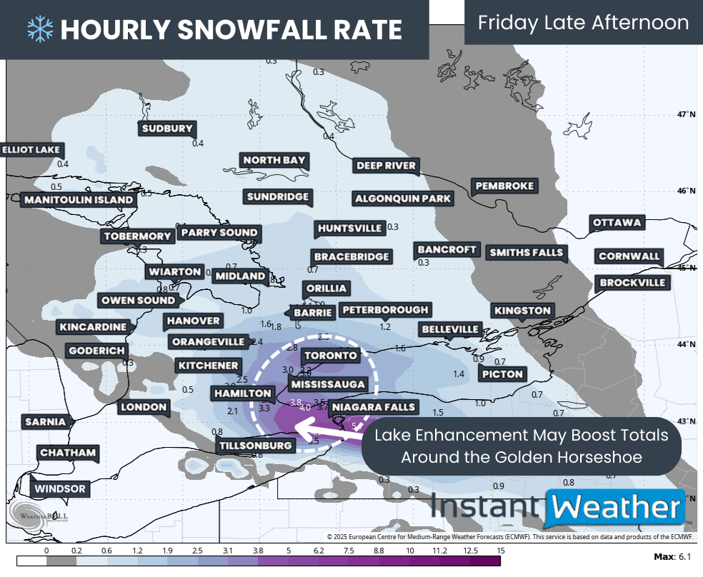
High-resolution model guidance continues to highlight an area of particularly intense snowfall rates across the Golden Horseshoe, driven by lake enhancement from Lake Ontario. Snowfall rates of 2 to 3cm per hour appear likely, with localized pockets potentially exceeding that where the embedded band becomes stationary.

The most intense part of this band may slowly drift westward into the Toronto area and linger for several hours during the late afternoon and early evening.

This is the window when snowfall could accumulate extremely quickly, potentially reaching 5cm per hour or more at times. Because this band will be very narrow, snowfall totals will vary dramatically from one neighborhood to the next. It is entirely possible for one part of the GTA to receive double the snowfall of another area only a few kilometres away.

Wind will also play a role, with gusts occasionally reaching 40 to 60 km/h. This will lead to areas of blowing snow and reduced visibility. While widespread blizzard conditions are not currently expected, localized blizzard-like conditions with near zero visibility cannot be ruled out under the heaviest snowfall bands.

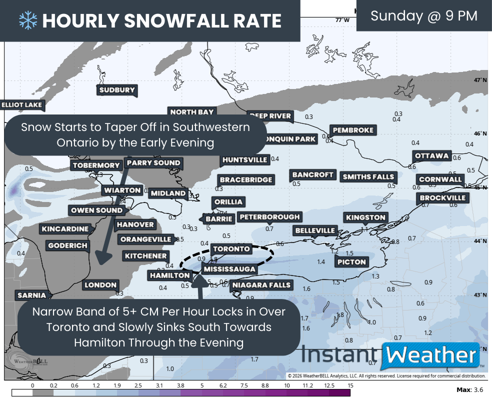
Hourly snowfall rates (cm) - MAP FROM WEATHERBELL

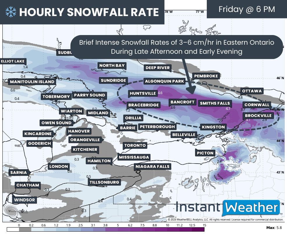
As the storm system pushes east into New England and Atlantic Canada, snowfall will begin to taper off across Southwestern Ontario during the evening hours. However, Eastern Ontario will just be reaching its peak snowfall during this time, with steady snow continuing through the evening from Kingston to Ottawa.

Across the Golden Horseshoe, conditions may actually worsen heading into Sunday evening as winds shift from easterly to northeasterly. This wind shift is expected to further intensify the lake effect band, allowing it to slide westward from Toronto into Mississauga, Oakville and eventually Burlington through the evening. Travel between Toronto and Hamilton during this period could be extremely difficult, and non-essential travel should be avoided if possible.

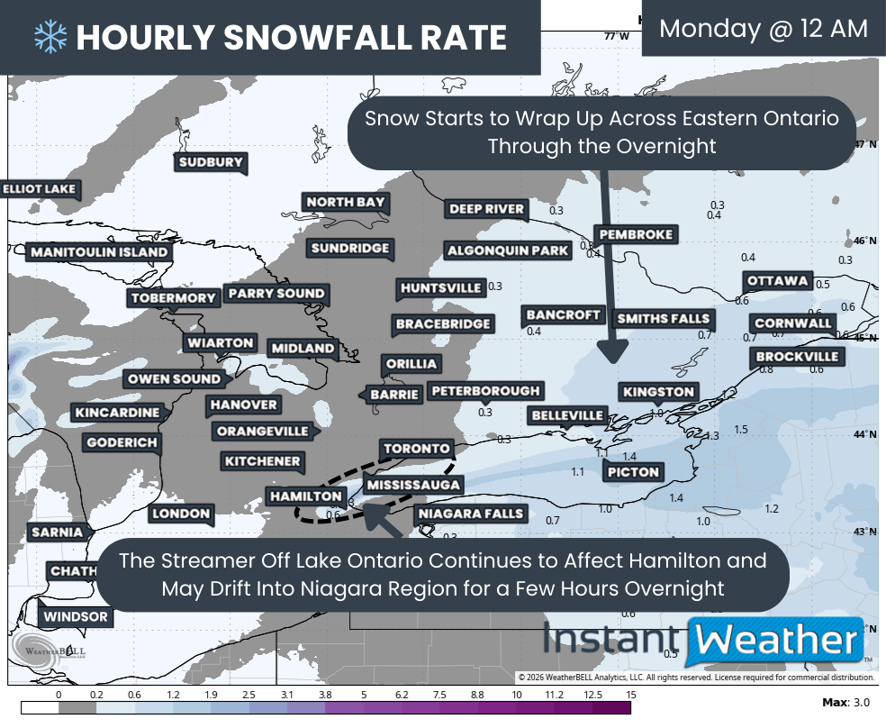
Hourly snowfall rates (cm) - MAP FROM WEATHERBELL

As Sunday night turns into early Monday morning, the bulk of the snowfall will become focused over Eastern Ontario as it winds down across most other parts of Southern Ontario.

The main exception will be the persistent lake effect band off Lake Ontario, which will now be free from the larger system. This band is expected to drift southward into Hamilton and potentially the northern Niagara region, including areas like Grimsby and St. Catharines, and could linger into the mid-morning hours on Monday.

For Eastern Ontario, snowfall should come to an end by around sunrise on Monday. However, the impacts will be far from over, as the amount of snow on the ground will almost certainly bring the Monday morning commute to a crawl.

NOTE: YOU CAN CLICK ON THE MAP TO OPEN A ZOOMABLE IMAGE

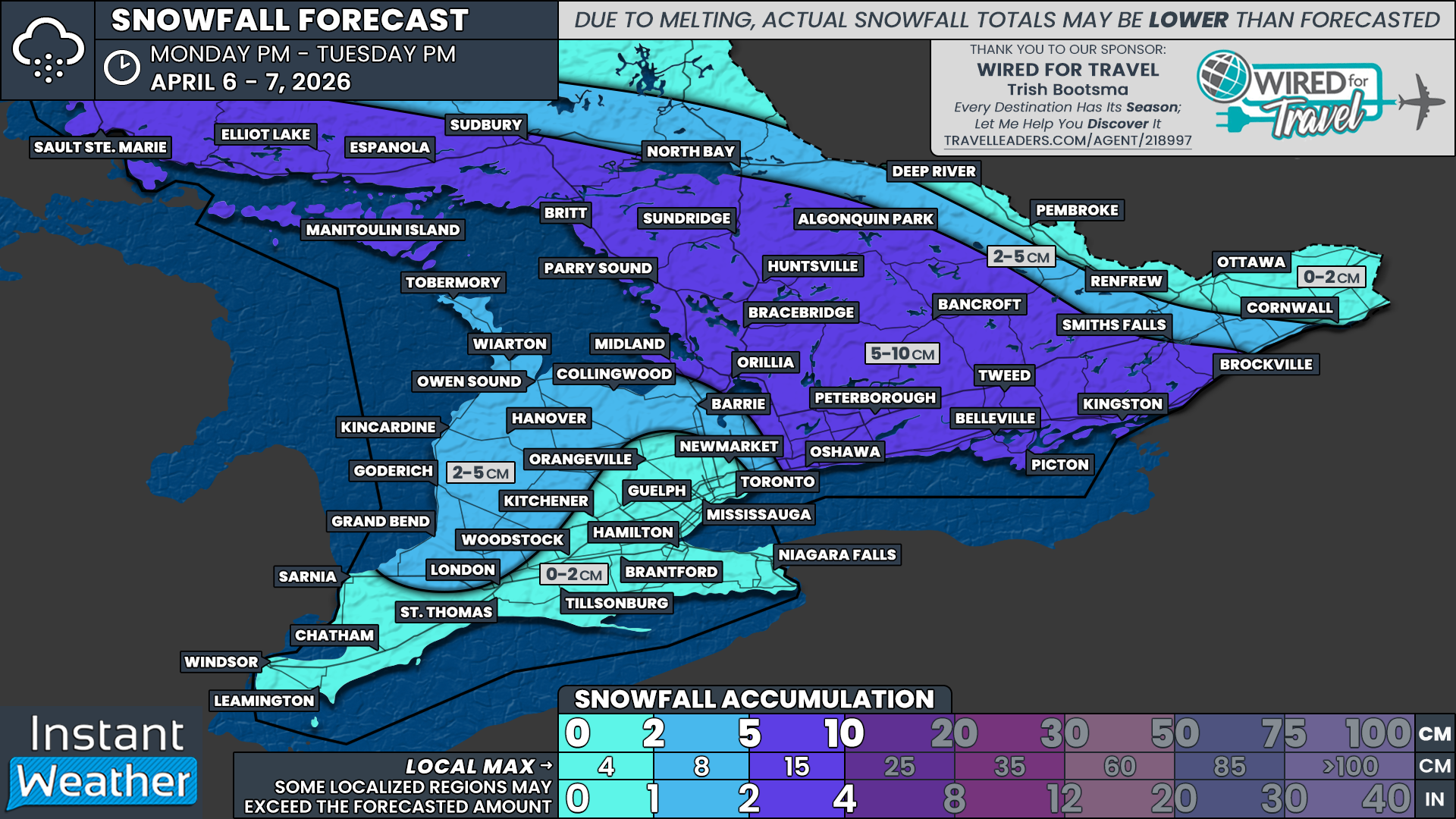
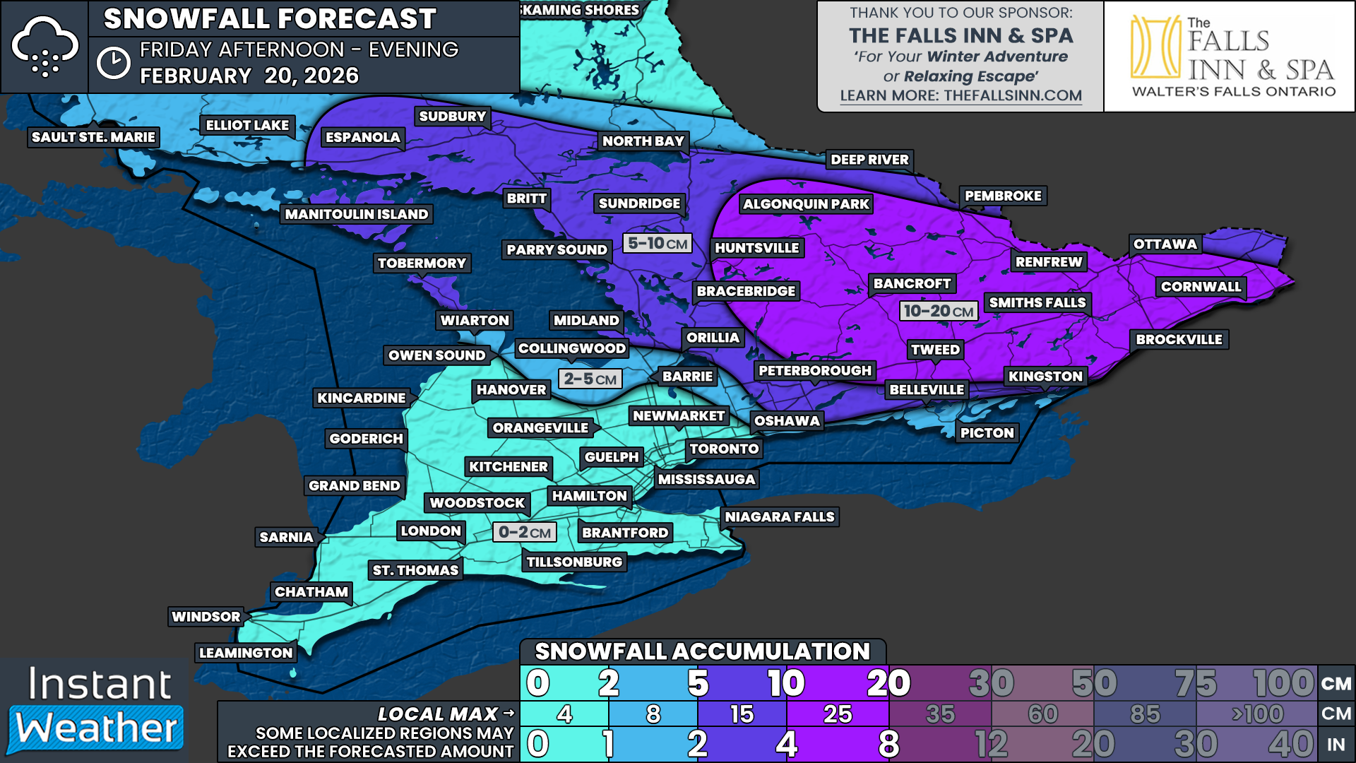
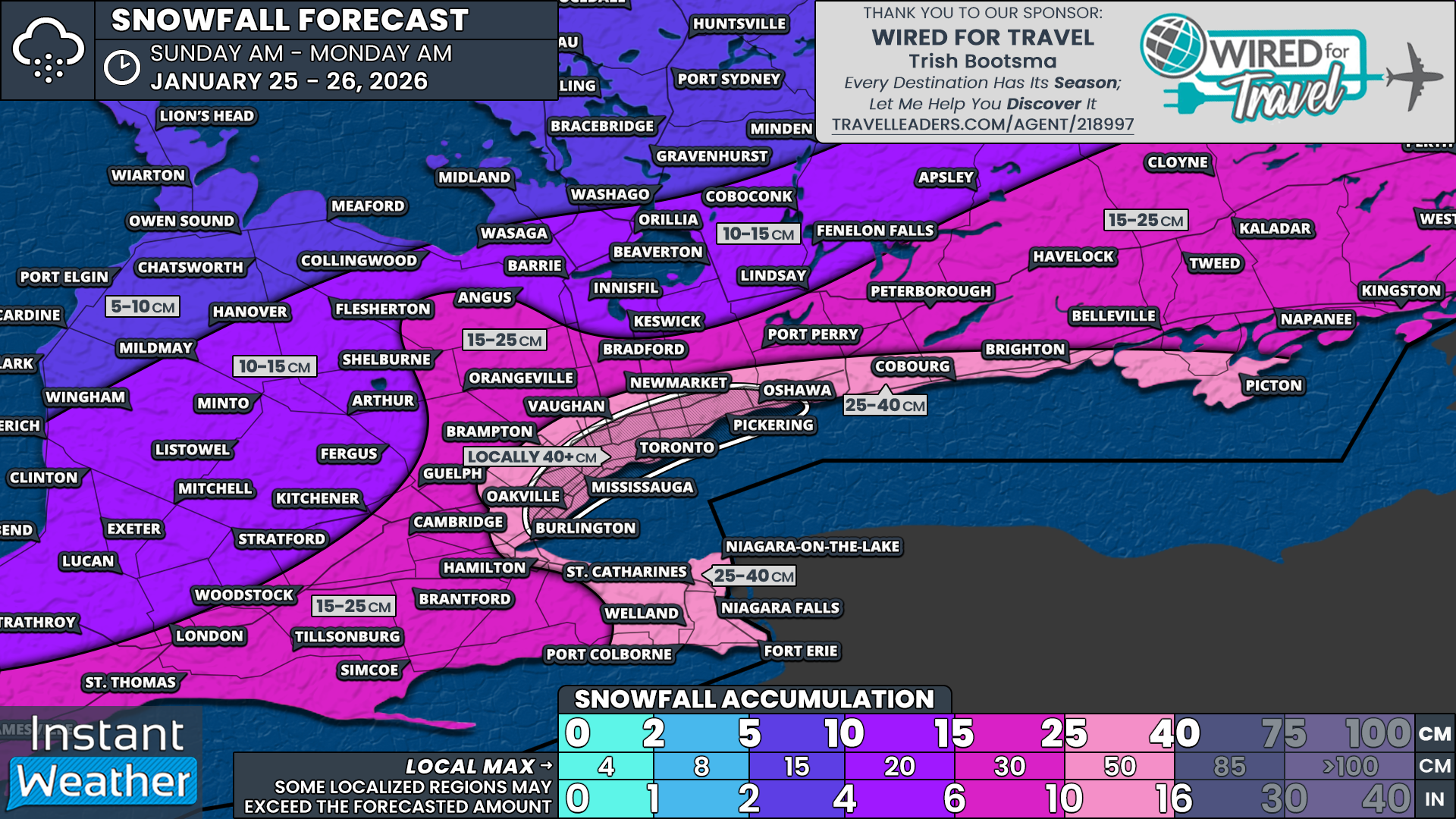
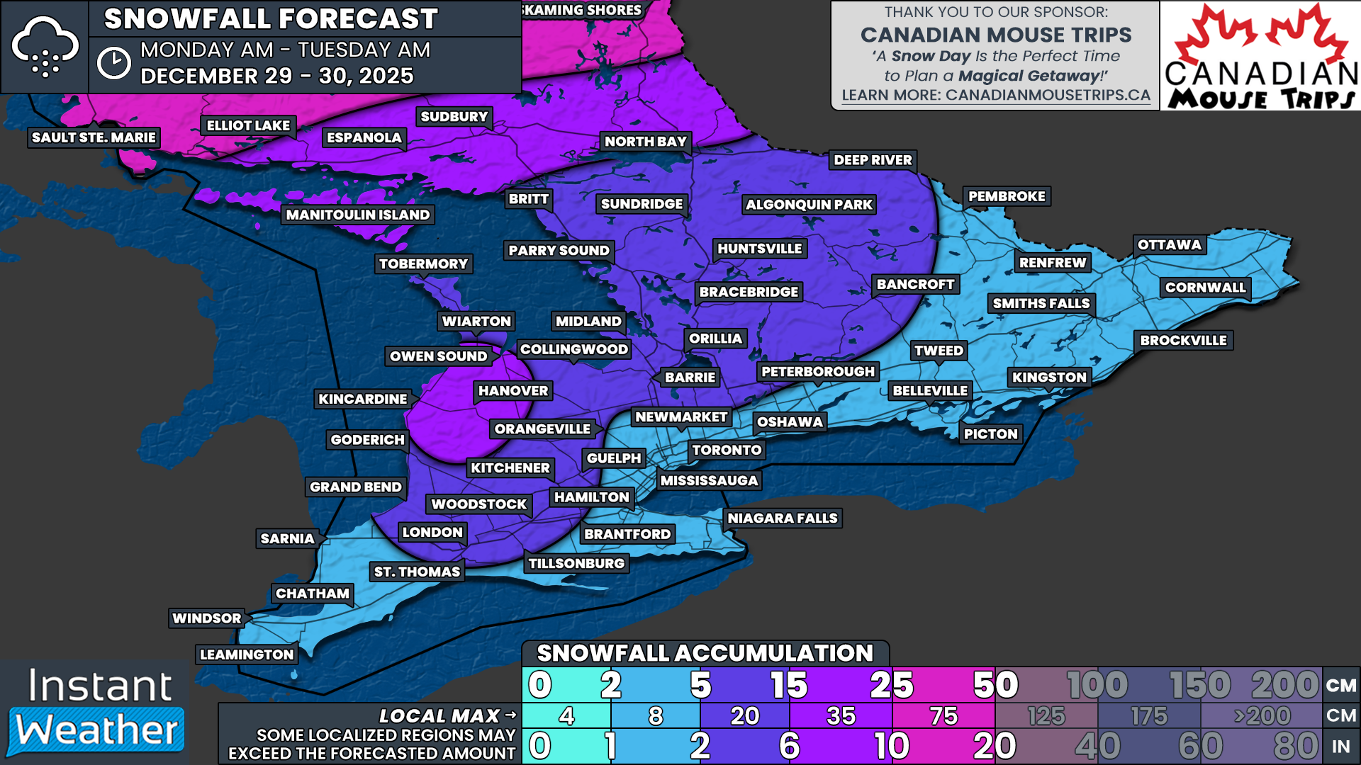
When all is said and done, snowfall totals by Monday morning will be highly variable, especially in areas affected by lake enhancement. A widespread zone along the Lake Ontario shoreline through the Golden Horseshoe is expected to see 25 to 40cm of snow.

This includes Picton, Brighton, Cobourg, Oshawa, Pickering, Toronto, Vaughan, Brampton, Mississauga, Oakville, Burlington, Hamilton, St. Catharines and Niagara Falls. Within this zone, the highest totals near 35 to 40cm will be very localized where the most intense lake enhancement persists, while many areas will fall closer to the 25 to 30cm range.

A smaller and more targeted corridor, including Oshawa, Pickering, Toronto, Vaughan, Mississauga and Oakville, has the potential to exceed 40cm if the lake effect band becomes particularly intense or remains stationary for several hours. This will lead to dramatic differences in snowfall even between nearby neighbourhoods.

NOTE: YOU CAN CLICK ON THE MAP TO OPEN A ZOOMABLE IMAGE

A broader area stretching from Windsor through London, Peterborough and into the Ottawa Valley can expect snowfall in the 15 to 25cm range. Some localized areas, particularly along the St. Lawrence River in Eastern Ontario, could see amounts closer to 30cm.

Snowfall totals will drop off farther northwest across Southern Ontario. Areas such as Sarnia, Goderich, Collingwood, Barrie, Orillia, Bancroft and Renfrew are currently forecast to receive 10 to 15cm. This zone remains highly sensitive to the exact northern edge of the precipitation shield, meaning totals could end up lower if the storm trends south, or higher if snowfall becomes more widespread than expected.

Finally, less than 10cm of snow is expected across Grey Bruce, Muskoka and Algonquin Park. For these regions, this will be a welcome break after enduring near continuous snow squall activity over the past week.

NOTE: YOU CAN CLICK ON THE MAP TO OPEN A ZOOMABLE IMAGE

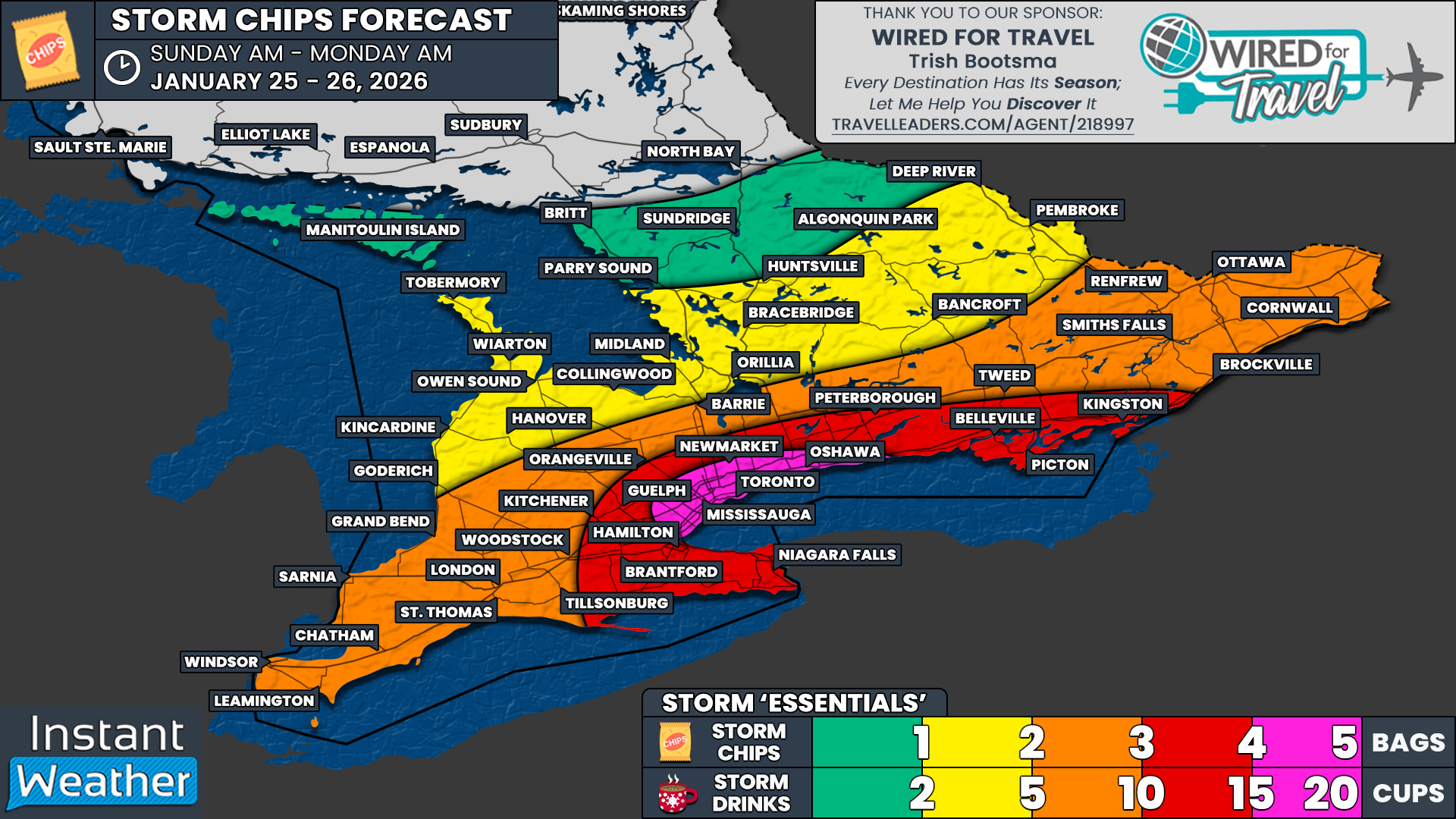
We know the real question on everyone’s mind is not how much snow is coming, but how many bags of storm chips are required to survive it. We’ve got you covered with our very non-scientific ‘storm chips’ forecast!

The heaviest snow is expected to focus along the western shoreline of Lake Ontario and extend into parts of the Greater Toronto Area, including Oshawa, Vaughan, Toronto, Mississauga, Brampton, Oakville and Burlington.

With widespread totals expected in the 20-40cm range, this is the kind of snowfall that doesn’t disappear overnight. Dense urban areas tend to grind to a halt during storms like this, and snow removal can take several days before things feel remotely normal again.

For that reason, we’ve officially dusted off the pink crayons. If you’re in this zone, we recommend a strong 4-5 bags of storm chips and about 15-20 cups of your favourite storm beverages to get you through the digging out phase.

Elsewhere along the Lake Ontario shoreline, from Kingston through Peterborough and around the Golden Horseshoe into Kitchener, Hamilton and the Niagara Region, impacts should still be solid. This zone is looking at a respectable 3-4 bags of storm chips and roughly 10-15 cups of storm drinks to ride out the storm in comfort.

Across the rest of Eastern Ontario into Deep Southwestern Ontario, including the Ottawa Valley, Barrie, and stretching down toward Windsor and London, snowfall totals in the 10-20cm range are expected.

While not extreme, this amount of snow will still make travel messy on Sunday and likely keep you home for the day. A sensible 2-3 bags of storm chips and 5-10 cups of storm drinks should do the trick here.

Further north into Central Ontario and Grey-Bruce, snowfall amounts look lighter, generally under 10cm. Considering what these areas have already endured from relentless snow squalls over the past week, this is almost a break. Still, it never hurts to be prepared, so we suggest 1-2 bags of storm chips and 2-5 storm drinks, just in case.

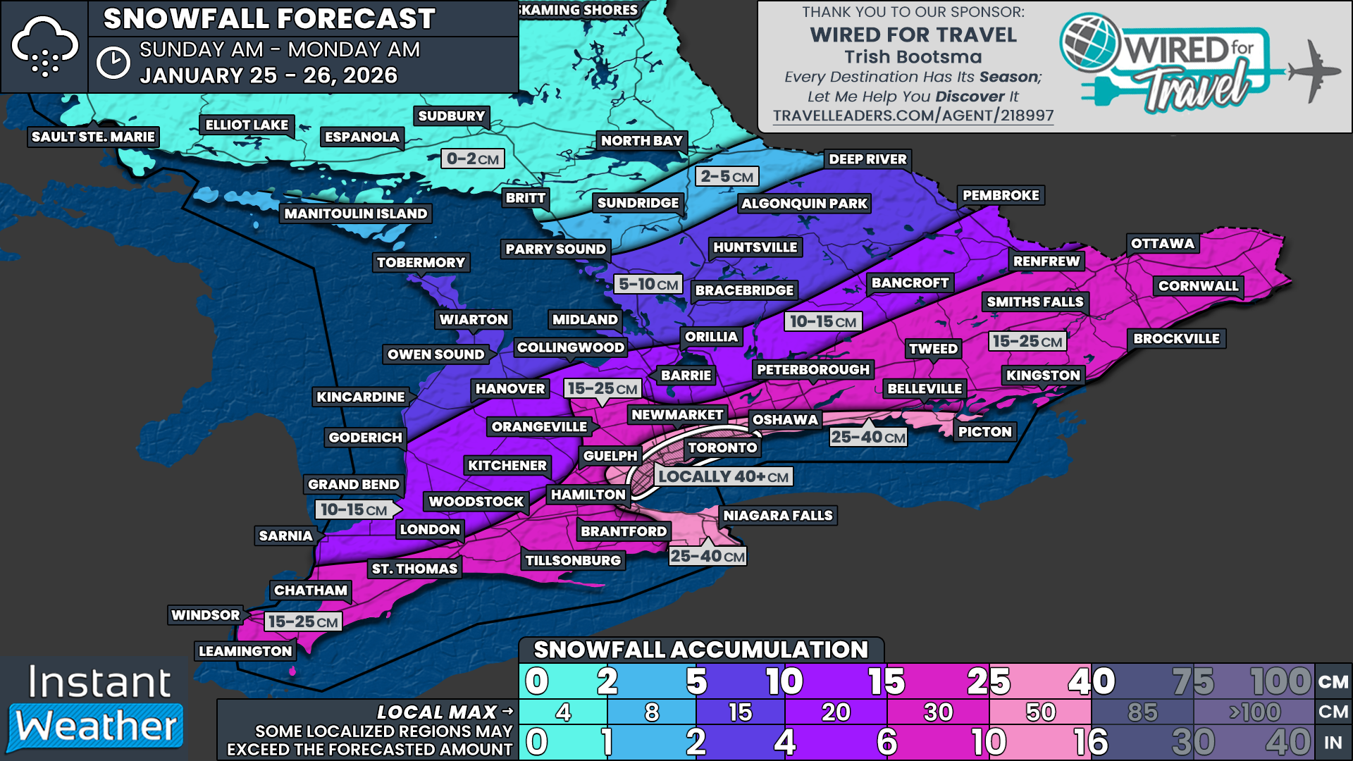
Another Major Snowstorm Targets the GTA and Parts of Southern Ontario on Sunday With Up to 20-40cm of Snow

NOTE: YOU CAN CLICK ON THE MAP TO OPEN A ZOOMABLE IMAGE

It has been just over a week since a high-impact snowstorm swept across Southern Ontario last Thursday, bringing widespread disruption and heavy snowfall to many communities. The hardest hit areas were centred on the Greater Toronto Area, where some neighbourhoods picked up more than 30 cm of snow in a relatively short period of time. That storm caused major travel issues, school disruptions, and a lengthy cleanup that is still fresh in many people’s minds.

That’s why the forecast for this upcoming weekend may sound eerily familiar. Another snowstorm is increasingly likely to impact many of the same areas that were hit last week. While this system will not be identical, there is once again the potential for significant snowfall, especially across the Golden Horseshoe. Some parts of the region could be digging out from over 20 cm of snow by Monday morning, with localized higher amounts still very much on the table.

A large and powerful winter storm that is expected to have a widespread impact across much of the Central and Eastern United States will begin pushing northward toward Southern Ontario on Sunday. This is a major system that will be producing destructive ice storm conditions in some areas and blizzard conditions in others south of the border. Thankfully, we will not see the worst of this storm locally.

Instead, Southern Ontario is expected to be brushed by the northeastern fringe of this expansive system. While that may sound like a glancing blow, it is more than enough to cause problems here. When combined with lake enhancement off Lake Ontario, this setup has the potential to produce a disruptive and high-impact snowstorm for the Golden Horseshoe and parts of Eastern Ontario.

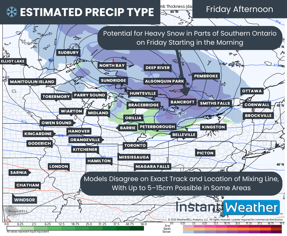
One of the biggest challenges with this forecast continues to be how far northwest the main bands of precipitation are able to push. Weather models are still not fully aligned on the exact placement of the heaviest snow, and that will make a big difference in who sees the highest totals. Central and Southwestern Ontario currently sit right on the edge of the storm’s reach.

If the system tracks a bit further east, some of these areas could see very little snow at all. On the other hand, a slightly more western track would bring accumulating snow much deeper into Southern Ontario and significantly expand the impact zone.

Confidence is much higher for areas closer to and east of the Lake Ontario shoreline. Regardless of the exact track, these regions are expected to see accumulating snow.

What remains uncertain is just how high the totals will climb. In a lower impact scenario, snowfall amounts would generally range from 20 to 25 cm around the GTA, with 10 to 20 cm extending eastward along the Lake Ontario shoreline into Eastern Ontario.

In a higher-end or overperforming scenario, localized pockets could approach 40 cm of snow, especially in and around the Toronto area. In that case, totals over 20 cm could extend across much of Eastern Ontario, parts of Central Ontario, and even into portions of Deep Southwestern Ontario. At this point, both outcomes remain plausible depending on how the system evolves.

Regardless of the final totals, this storm is expected to produce hazardous travel conditions, especially as snowfall intensity ramps up Sunday afternoon and evening. Roads are likely to become snow-covered and slippery, with visibility reduced at times during heavier bursts of snow. Conditions should slowly begin to improve overnight into Monday morning, but the impacts will not end there.

Given the amount of snow that is likely to fall, there is a high probability of significant impacts to the Monday morning commute. This includes the strong potential for school bus cancellations and school closures across parts of Southern and Eastern Ontario. Even if snowfall tapers off before daybreak, cleanup operations will still be ongoing during the morning hours.

Hourly snowfall rates (cm) - MAP FROM WEATHERBELL

While we will have a more detailed look at timing in our final forecast late Saturday, current data suggests snowfall will begin to spread over parts of Southern Ontario late Sunday morning. Steady snow is expected to reach Deep Southwestern Ontario around 8 to 9 AM, gradually expanding northeastward through the day.

At the same time, there are growing signals that a lake effect snow band may develop over Lake Ontario and extend into areas north and northwest of the lake. This band could stretch from Belleville along the Highway 401 corridor, through Toronto, and westward toward Hamilton. This is an important detail, as lake enhancement could significantly boost snowfall totals in a narrow corridor.

High-resolution models are just beginning to come into range, but early indications show elevated snowfall totals along this corridor. In some cases, 10 to 20 cm of snow could fall even before the main system snow arrives later Sunday afternoon and evening. This would set the stage for very high totals once the storm fully ramps up.

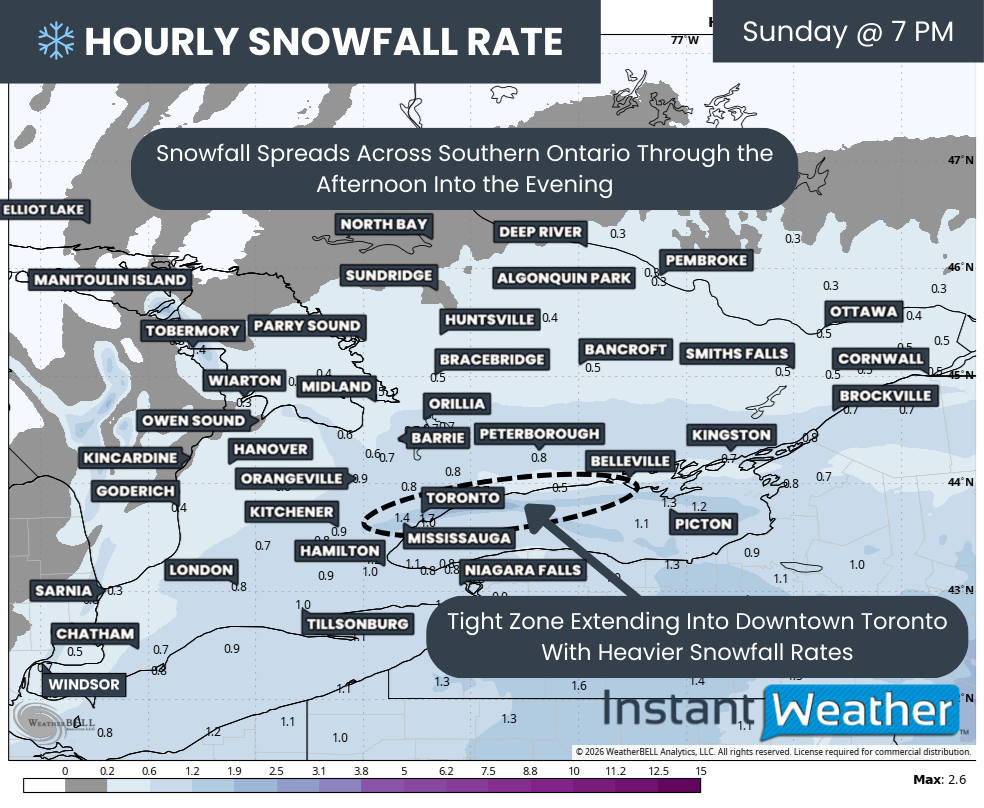
Hourly snowfall rates (cm) - MAP FROM WEATHERBELL

The steadier, more widespread snow associated with the main system will continue to spread northeastward during the afternoon. Snowfall intensity is expected to increase through the Golden Horseshoe and into Central and Eastern Ontario as the evening progresses, with the heaviest rates focused near Lake Ontario.

Models are also hinting at the possibility of an embedded lake effect streamer developing and narrowly extending into parts of the western GTA. This includes Downtown Toronto and potentially Mississauga. If this band materializes, it would likely develop sometime during the afternoon and intensify into the evening hours.

The exact placement of this feature is highly uncertain and could shift around considerably. Because of that, snowfall totals could vary dramatically over relatively short distances. Where this band sets up, snowfall rates could double or even triple compared to surrounding areas, leading to very rapid accumulation in a short amount of time.

As the system begins to wind down overnight, this pocket of lake enhancement is expected to gradually weaken. Current model guidance suggests it may slowly sink southward through areas like Oakville, Burlington, and Hamilton as winds shift from easterly to northeasterly. This could prolong snowfall in those communities even as conditions improve elsewhere.

Most areas should see the snow taper off by around sunrise on Monday. However, parts of Eastern Ontario may see steadier snow linger through the morning hours before finally ending by the afternoon. Even after the snow stops, cleanup and travel impacts will continue for much of the day.

NOTE: YOU CAN CLICK ON THE MAP TO OPEN A ZOOMABLE IMAGE

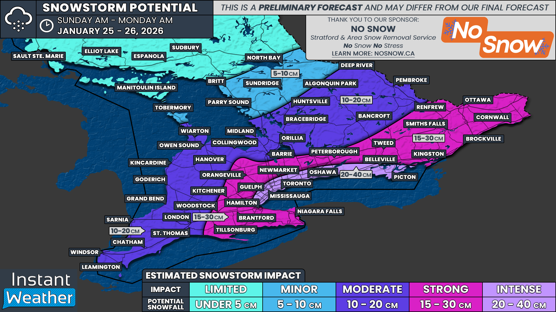
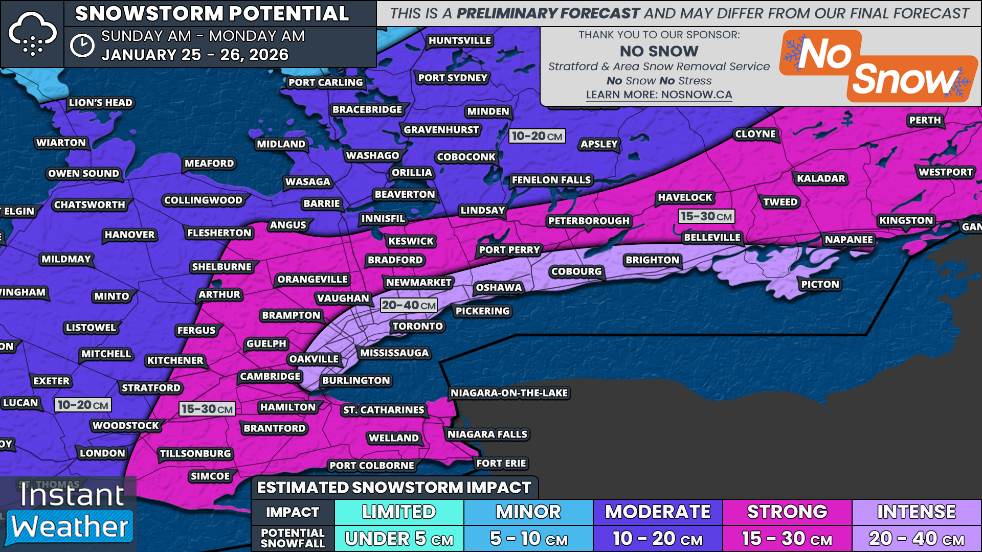
When it comes to potential snowfall totals, this is shaping up to be a storm with significant variability, even across small areas. The lake enhancement component means there will likely be a narrow corridor somewhere through the GTA where totals approach or even exceed 40 cm, while nearby locations receive much less.

At this time, the highest totals are expected along the northern and western shoreline of Lake Ontario. Snowfall amounts in this zone are forecast to range from 20 to 40 cm. This includes areas such as Picton, Belleville, Brighton, Cobourg, Oshawa, Pickering, Toronto, Vaughan, Mississauga, Oakville, and Burlington.

Somewhere between Oshawa and Oakville, localized pockets near 40 cm appear most likely, which seems to be likely focused on parts of Toronto. Outside of those hotspots, much of this corridor is expected to fall into the 20 to 30 cm range. There is still a chance that totals could exceed 40 cm if the lake enhancement band is stronger or lingers longer than expected, though recent model runs suggest less overperforming potential than earlier data.

The rest of the Golden Horseshoe and much of Eastern Ontario away from the immediate Lake Ontario shoreline can expect generally 15 to 30 cm of snow from this storm. This includes places like Niagara, Brantford, Kitchener, Guelph, Orangeville, Newmarket, Peterborough, Kingston, Brockville, Ottawa, and Cornwall. We expect to tighten this range further once the storm track becomes clearer.

For Southwestern Ontario into parts of Central Ontario, current projections suggest totals in the 10 to 20 cm range. However, there is expected to be a very sharp cutoff on the northwest edge of the precipitation shield. This means snowfall totals could drop off quickly over short distances.

If the system does not extend far enough northwest, areas east of Lake Huron and Georgian Bay could end up being mostly clipped by the snow, with minimal accumulation. In contrast, Deep Southwestern Ontario including Windsor, Chatham, and London appears most likely to see at least 10 cm of snow regardless of the final track.

Overall confidence in this forecast is fairly high thanks to strong agreement among most weather models. That said, the storm is still more than 24 hours away. This forecast remains preliminary and could change if there is a last minute shift in the data. While a major surprise is unlikely given the current consistency, it cannot be completely ruled out.

Our final forecast will be published Saturday evening once the latest data is available. At that time, we will provide a more precise snowfall range and a detailed timing breakdown so you have a clearer picture of what to expect throughout the day on Sunday and into Monday.

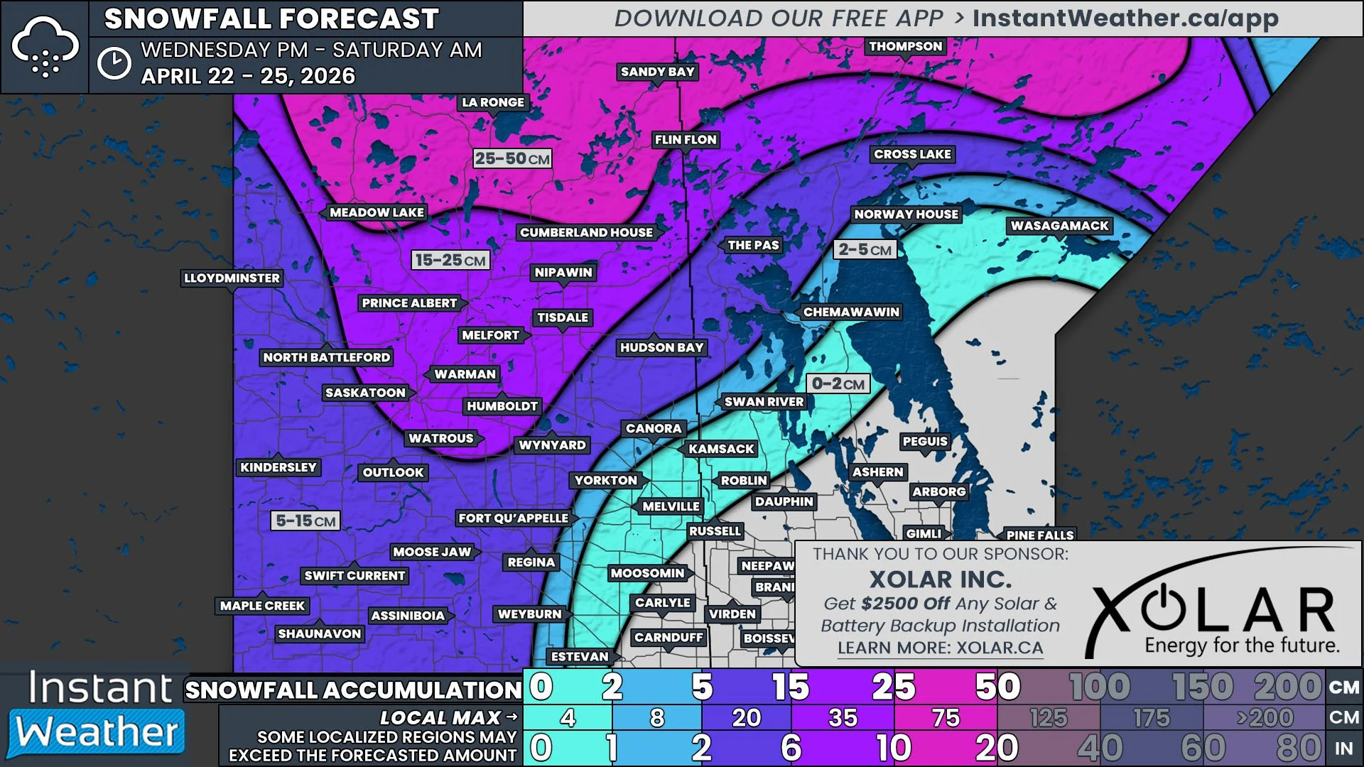
Snowy One-Two Punch Targets Southern Ontario Starting Wednesday as Alberta Clipper and Squalls Dump Up to 25 to 50 cm of Snow

NOTE: YOU CAN CLICK ON THE MAP TO OPEN A ZOOMABLE IMAGE

The story of the week so far across Southern Ontario has been the relentless snow squall activity that has been hammering the region, bringing treacherous travel conditions as a surge of Arctic air continues to sit overhead. These squalls have been anything but minor, producing frequent whiteouts, rapidly deteriorating road conditions, and dangerous travel at times.

The worst of the impacts on Tuesday was when intense snow squalls forced the closure of multiple stretches of Hwy 11 between Bracebridge and Orillia. Whiteout conditions combined with rapidly accumulating snow led to several accidents, leaving many drivers stranded and highlighting just how dangerous these squalls can become when they lock into place.

While the snow squalls are far from finished, the threat zone is expected to shift over the next few days as winds gradually turn more westerly. This change in wind direction will push the most persistent squall activity away from areas that were hit earlier this week and refocus it further west and north.

As a result, locations such as the Bruce Peninsula, Muskoka, Parry Sound, and even areas further inland like Haliburton and Bancroft are expected to see the most significant impacts through the second half of the week.

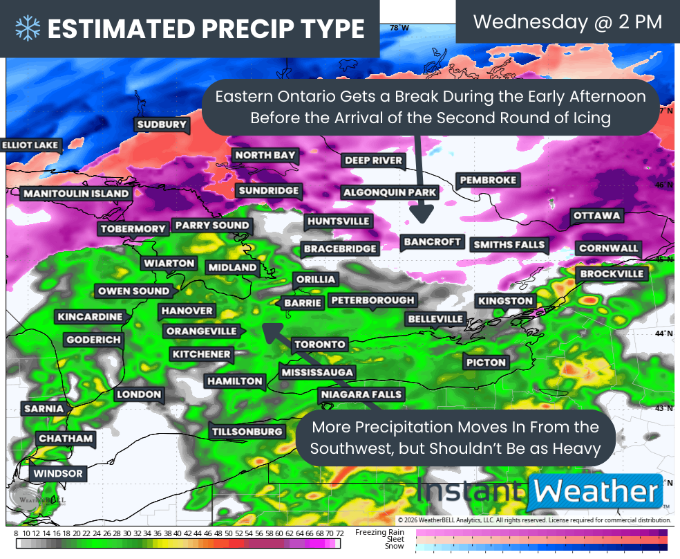
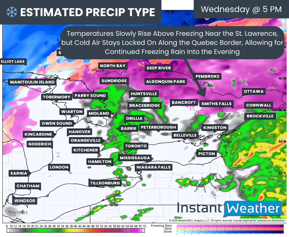
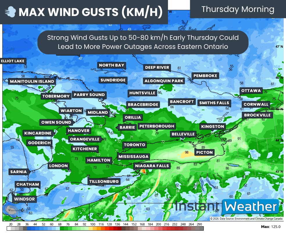
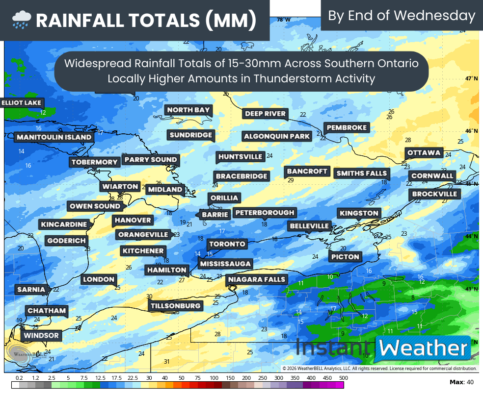
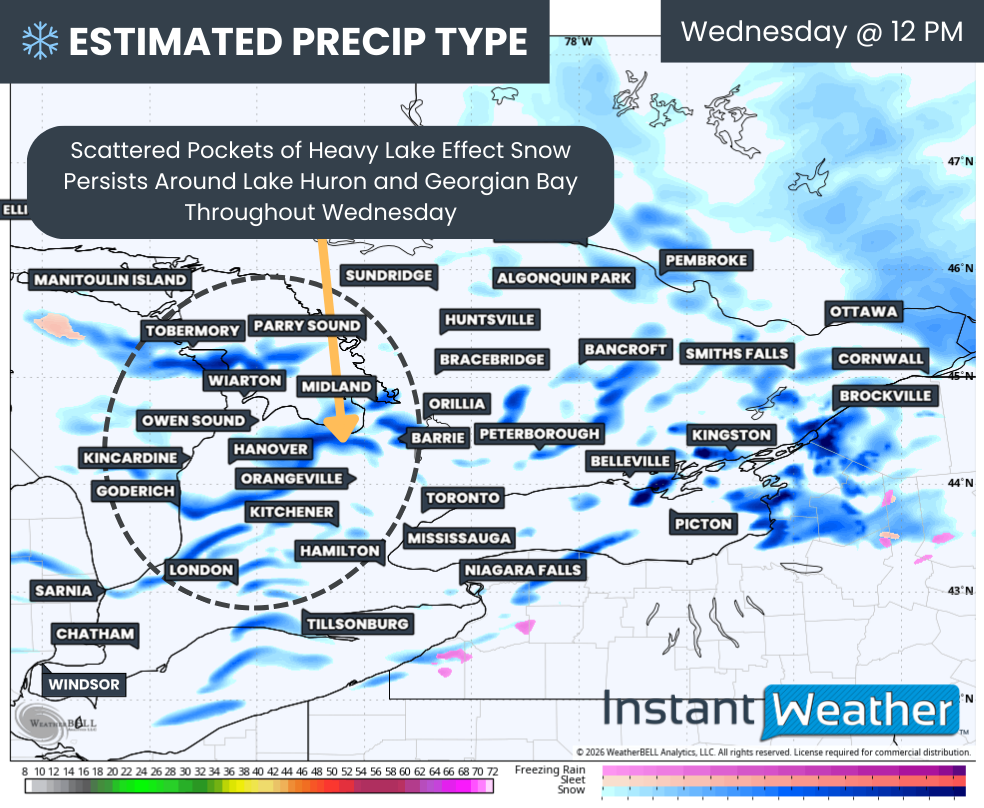
Snow squall activity will briefly weaken during the day on Wednesday, but this will not be because the atmosphere is calming down. Instead, an Alberta Clipper is expected to move into Southern Ontario beginning Wednesday morning, temporarily disrupting the lake effect setup.

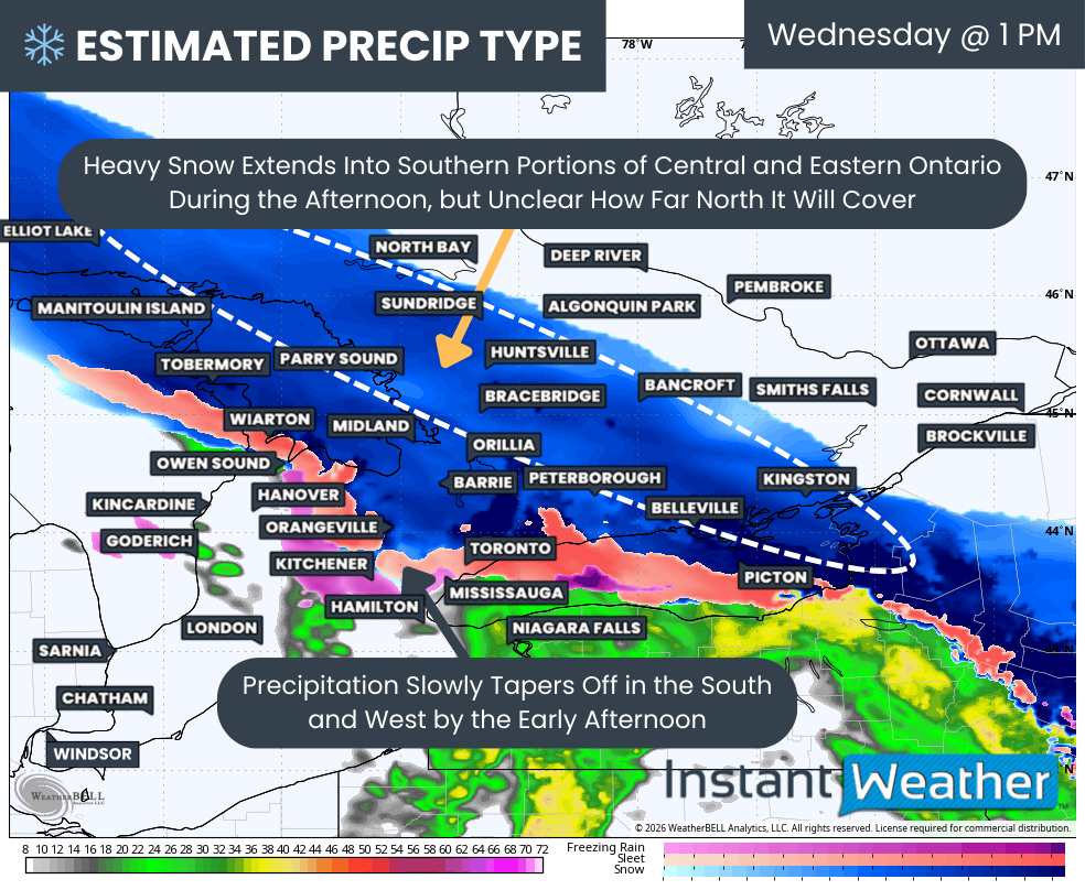
This clipper will spread a shield of steady light to moderate snow across Southwestern Ontario, extending through the Golden Horseshoe and into Eastern Ontario as the day goes on. While this system is not expected to produce extreme snowfall amounts on its own, it will still have notable impacts due to its timing and the already poor road conditions in many areas.

Compared to the storm some locations experienced last week, snowfall totals with this system will be more modest. However, the combination of falling snow, reduced visibility, and slick road surfaces could still make both the morning and evening commute hazardous in spots.

At this point, we are expecting a general 5 to 10 cm from the Alberta Clipper. As is typical with these systems, snowfall will not be uniform. Alberta Clippers are often moisture-starved, which can lead to dry pockets where snowfall totals underperform, while narrow bands of heavier snow can locally boost amounts closer to 15 cm.

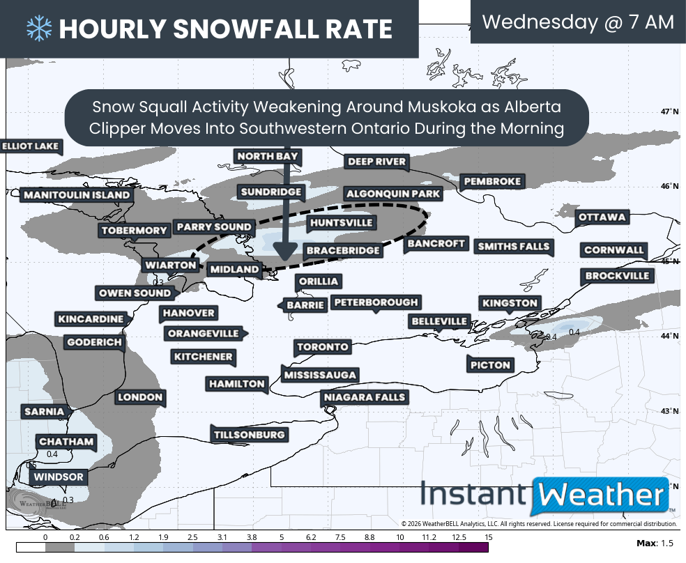
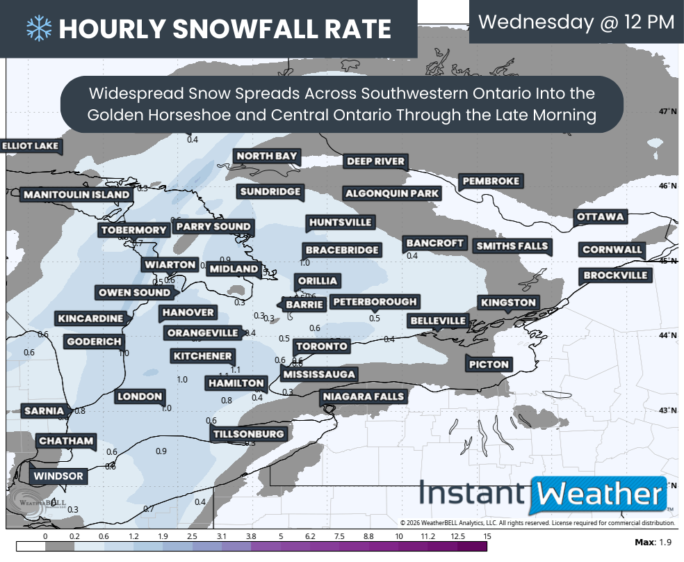
Hourly snowfall rates (cm) - MAP FROM WEATHERBELL

Snow squalls that are already developed east of Georgian Bay will continue to impact the Parry Sound and Muskoka region through the overnight hours and into Wednesday morning. Travel conditions in these areas will remain poor early in the day, especially where bands remain persistent.

As the clipper approaches, winds will begin to shift by mid-morning, weakening the squalls and temporarily shutting down the lake effect snow machine. This will offer a short-lived improvement in conditions for areas east of Georgian Bay before the next phase of the pattern kicks in.

The outer bands of snow associated with the Alberta Clipper will begin to move into Deep Southwestern Ontario around sunrise, affecting areas such as Windsor, Sarnia, and Chatham. From there, the snow will steadily expand northeastward through the late morning hours.

Hourly snowfall rates (cm) - MAP FROM WEATHERBELL

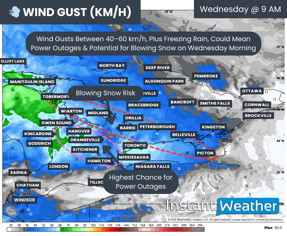
By midday, snow will be falling across much of Southwestern Ontario and into the Golden Horseshoe and Central Ontario. Snowfall rates are not expected to be overly intense, generally topping out around 1-2 cm per hour, but wind gusts of 40 to 60 km/h could still lead to areas of blowing snow and reduced visibility.

Model guidance is also hinting at the development of a dry slot north of the GTA, particularly around Lake Simcoe. This includes areas such as Collingwood, Barrie, and parts of York Region, where snowfall rates could be noticeably lower.

This is a common issue with Alberta Clippers. While the Great Lakes can often help enhance snowfall by adding moisture, regions around Lake Simcoe may miss out when winds are predominantly southerly. In this setup, they sit outside the direct influence of Lake Erie and Lake Ontario moisture feeds.

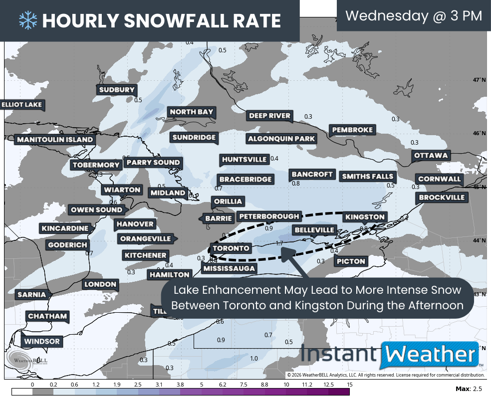
Hourly snowfall rates (cm) - MAP FROM WEATHERBELL

On the flip side, the Toronto to Kingston corridor is expected to benefit from Lake Ontario enhancement. This added moisture could push snowfall totals closer to 10 to 15 cm in this zone, slightly higher than surrounding areas.

This enhanced snowfall is also expected to coincide with the evening commute, particularly along Hwy 401 east of Toronto toward Kingston. Drivers should be prepared for rapidly changing conditions, with visibility dropping quickly at times as heavier bursts of snow move through.

Light snow will also spread into the Ottawa Valley by early afternoon. However, snowfall totals will likely taper off the further north you go as the influence of Lake Ontario weakens. Ottawa itself may only pick up a few centimetres by the time the snow winds down Wednesday evening.

Snow from the clipper is expected to gradually taper off from west to east by the late afternoon or early evening as the system exits Eastern Ontario. Unfortunately, this break will be brief for snowbelt regions.

Hourly snowfall rates (cm) - MAP FROM WEATHERBELL

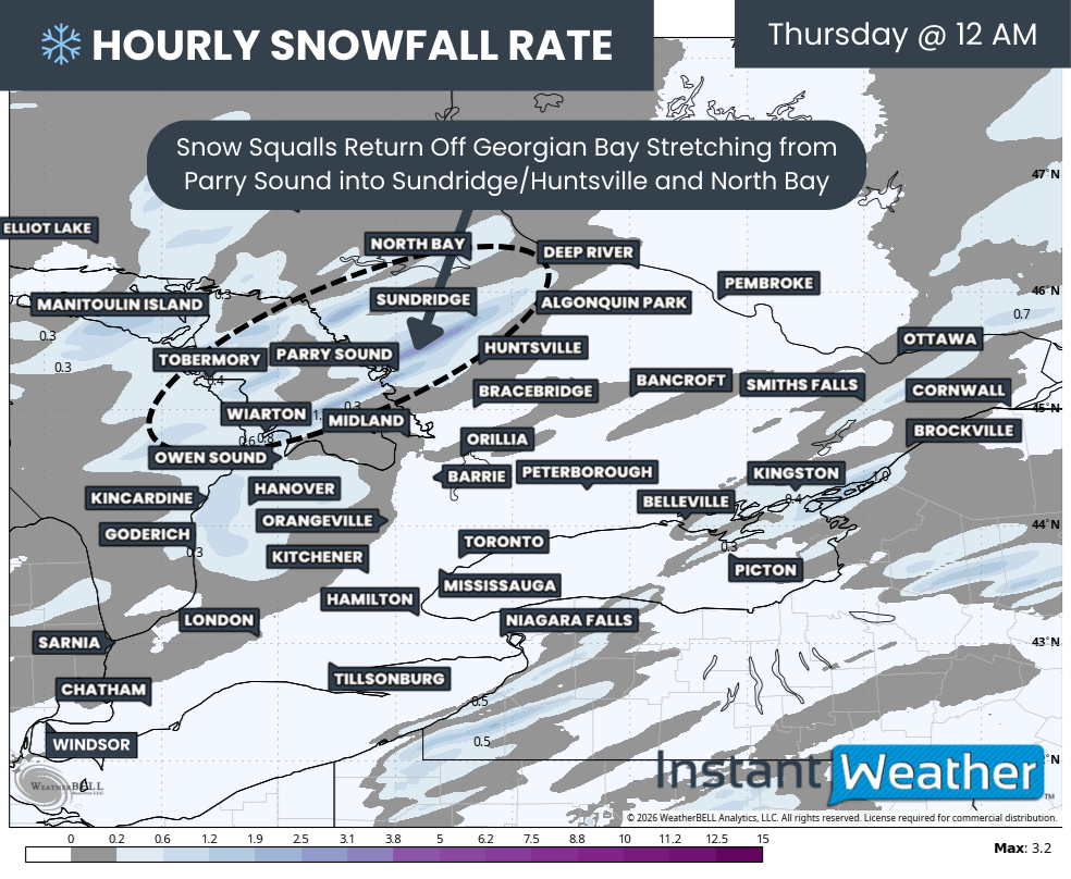
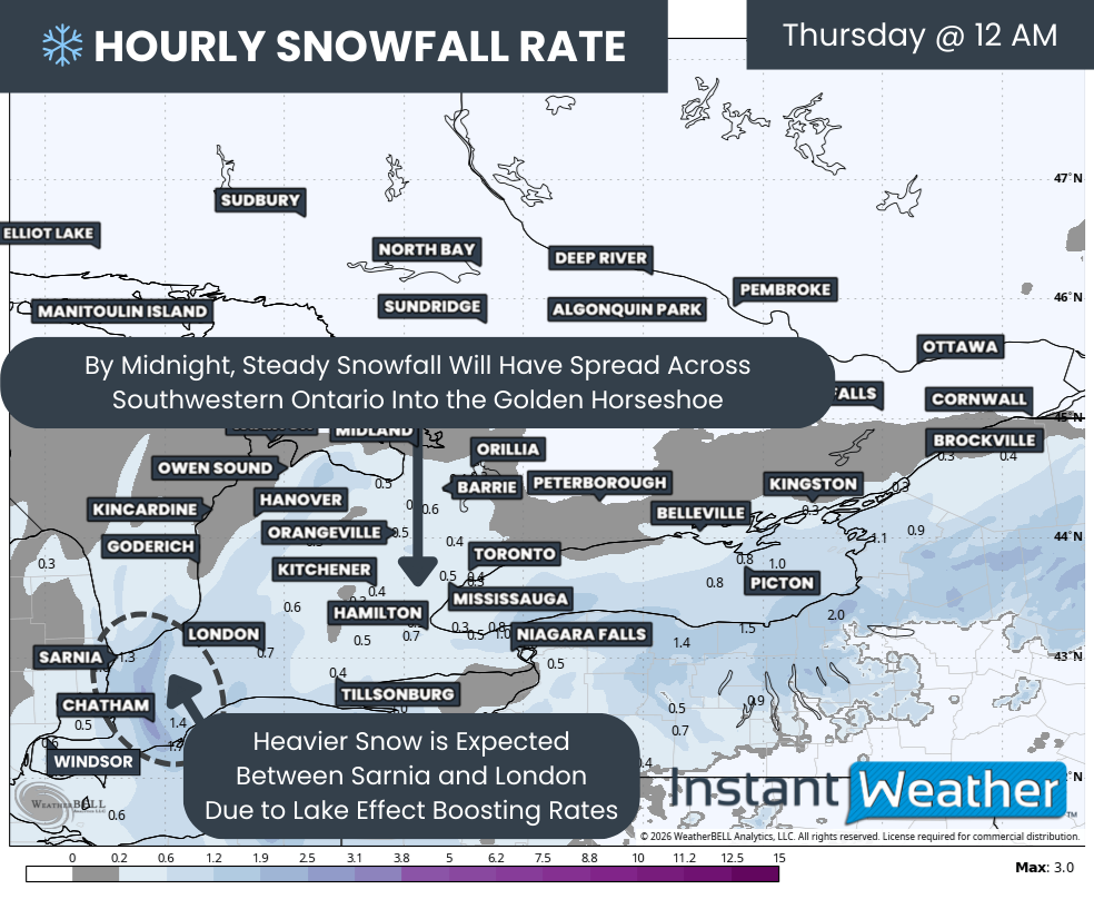
As the system departs, lake effect snow is expected to rapidly redevelop overnight Wednesday as winds settle into a southwesterly direction. This will allow the lake effect machine to roar back to life.

The brunt of the snow squall activity overnight will be focused on the Bruce Peninsula, Parry Sound, and North Muskoka. At times, these squalls could stretch further inland toward areas like Sundridge and even North Bay.

Travel conditions overnight into Thursday are expected to be very poor. Snowfall rates may become intense within the strongest bands, and it is quite possible that sections of Hwy 400 or Hwy 11 could see temporary closures if snow accumulates faster than crews can keep up. Travel in these areas is highly discouraged.

Hourly snowfall rates (cm) - MAP FROM WEATHERBELL

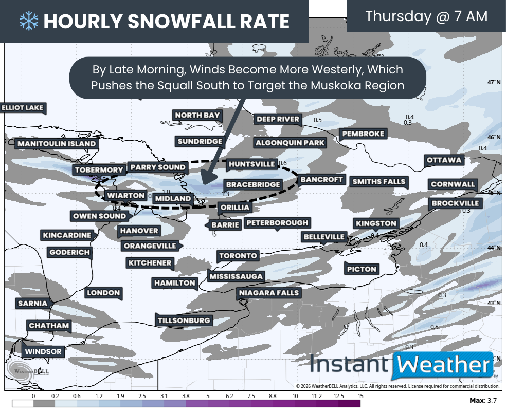
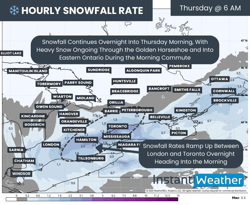
By sunrise Thursday, winds are expected to gradually turn more westerly. This shift will cause the main squall to sink southward into Muskoka, targeting locations such as Bracebridge, Port Carling, Baysville, Port Sydney, Rosseau, and MacTier.

Some model guidance suggests this squall could become nearly stationary through much of the day Thursday. If this scenario verifies, snowfall totals could quickly climb, with some areas potentially exceeding 50 cm by the end of Thursday.

Other models suggest a more oscillating band that shifts north and south throughout the day. While this would limit extreme totals in one single location, it would spread significant snowfall across a broader portion of Muskoka and Parry Sound.

Hourly snowfall rates (cm) - MAP FROM WEATHERBELL

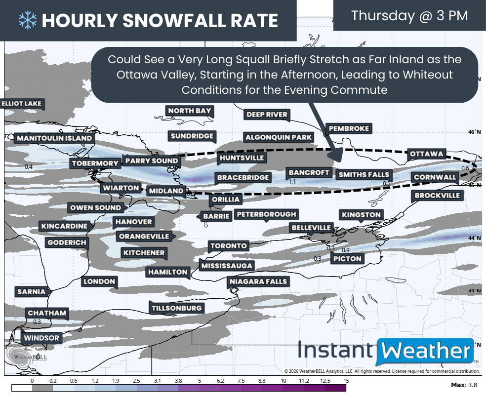
As we head into Thursday afternoon, the impacts of the Georgian Bay squall may extend beyond the typical snowbelt. Strengthening winds could allow the band to push further inland, potentially reaching parts of Eastern Ontario and even the Ottawa Valley.

Locations such as Bancroft, Smiths Falls, Renfrew, and Ottawa could see several hours of heavy snow, leading to sudden whiteout conditions right during the evening commute. These whiteouts can occur with very little warning, making it critical for drivers to remain alert and be ready to adjust their driving immediately.

It could also bring a quick 5-10cm to the Ottawa Valley, which, combined with the Alberta Clipper, puts them in the 5-15cm range despite missing the worst of the clipper.

Additional lake effect snow is also possible east of Lake Huron during the day on Thursday, affecting Grey Bruce, along with parts of Huron and Perth Counties. While models are not showing a well-organized band at this time, wind gusts near 60 km/h could still lead to blowing snow and reduced visibility.

Snow squall activity is likely to persist into Thursday night and possibly into Friday morning. This forecast cuts off at the end of Thursday, with a separate update planned to cover Friday and beyond.

NOTE: YOU CAN CLICK ON THE MAP TO OPEN A ZOOMABLE IMAGE

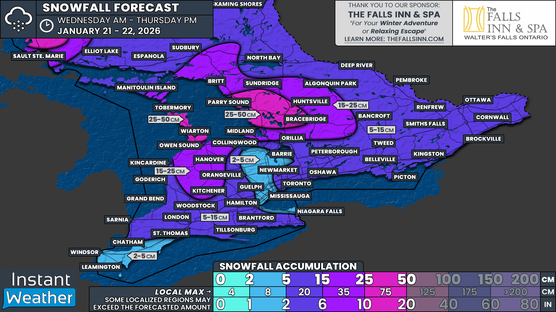
In terms of snowfall totals, most areas away from the lake effect are expected to see around 5 to 10 cm from the Alberta Clipper alone. Some pockets will fall short of that, while others may exceed it slightly, depending on lake enhancement.

That is why regions not expecting lake effect snow are generally placed in the 5 to 15 cm range. This includes much of Eastern Ontario, parts of the eastern GTA, and most of Southwestern Ontario.

Exceptions include areas northwest of the GTA, such as Barrie, Keswick, Bradford, Orangeville, and Angus, as well as Deep Southwestern Ontario, including Windsor, Leamington, and Chatham. These locations are expected to see less moisture and may remain below 5 cm. The same applies to the western GTA and Hamilton.

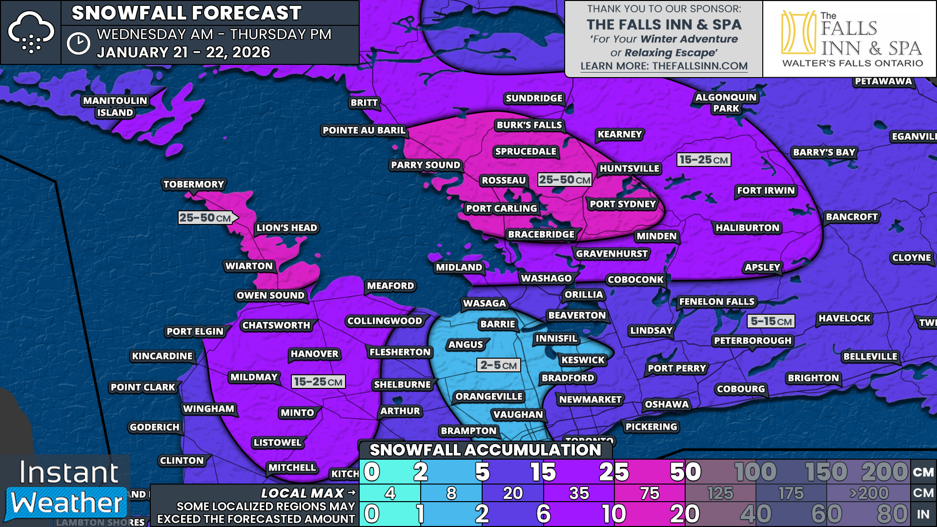
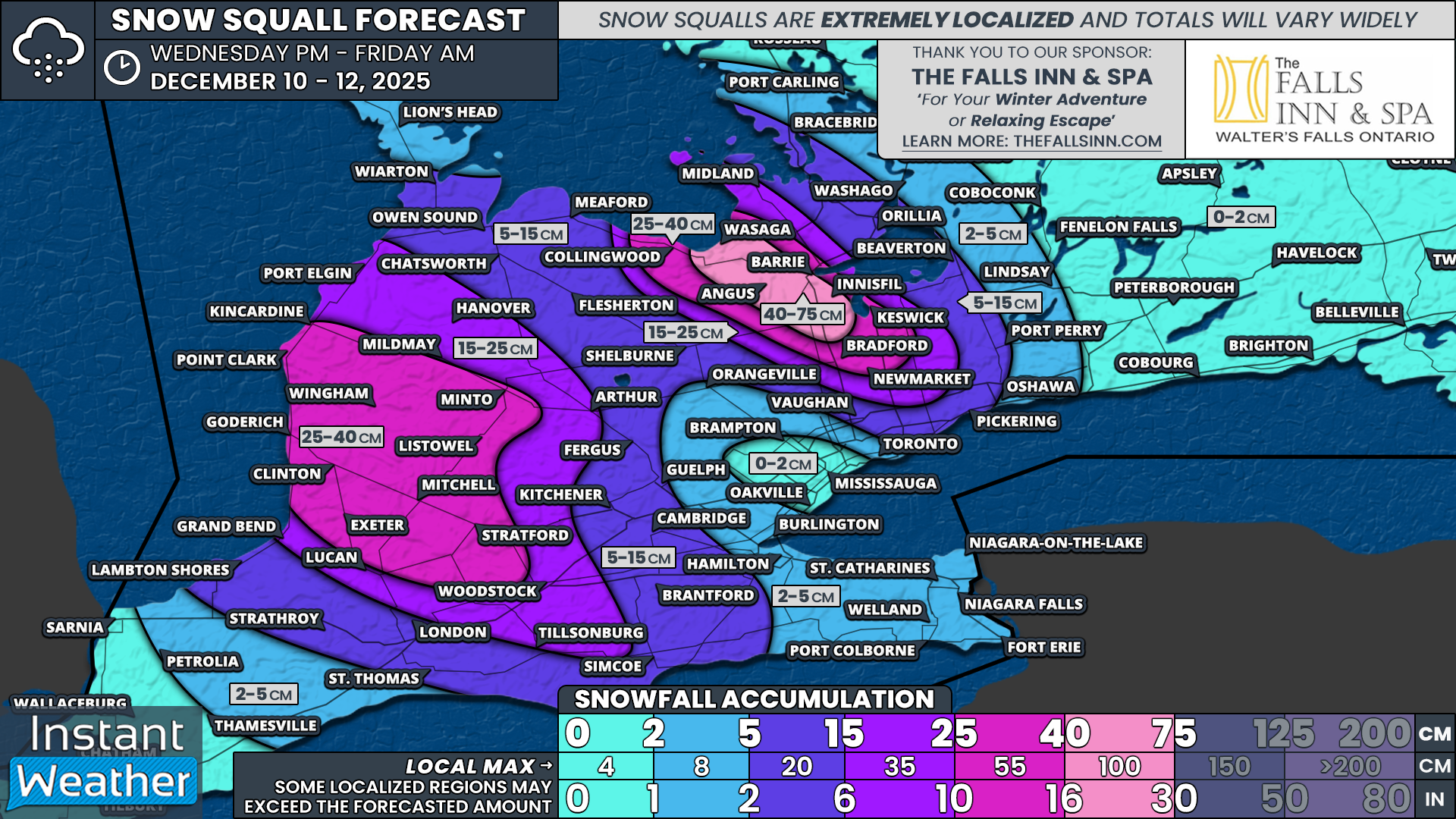
Once lake effect snow is factored in, totals increase quickly east of Georgian Bay. This includes snowfall from early Wednesday before the clipper arrives and the more intense squalls that follow on Thursday.

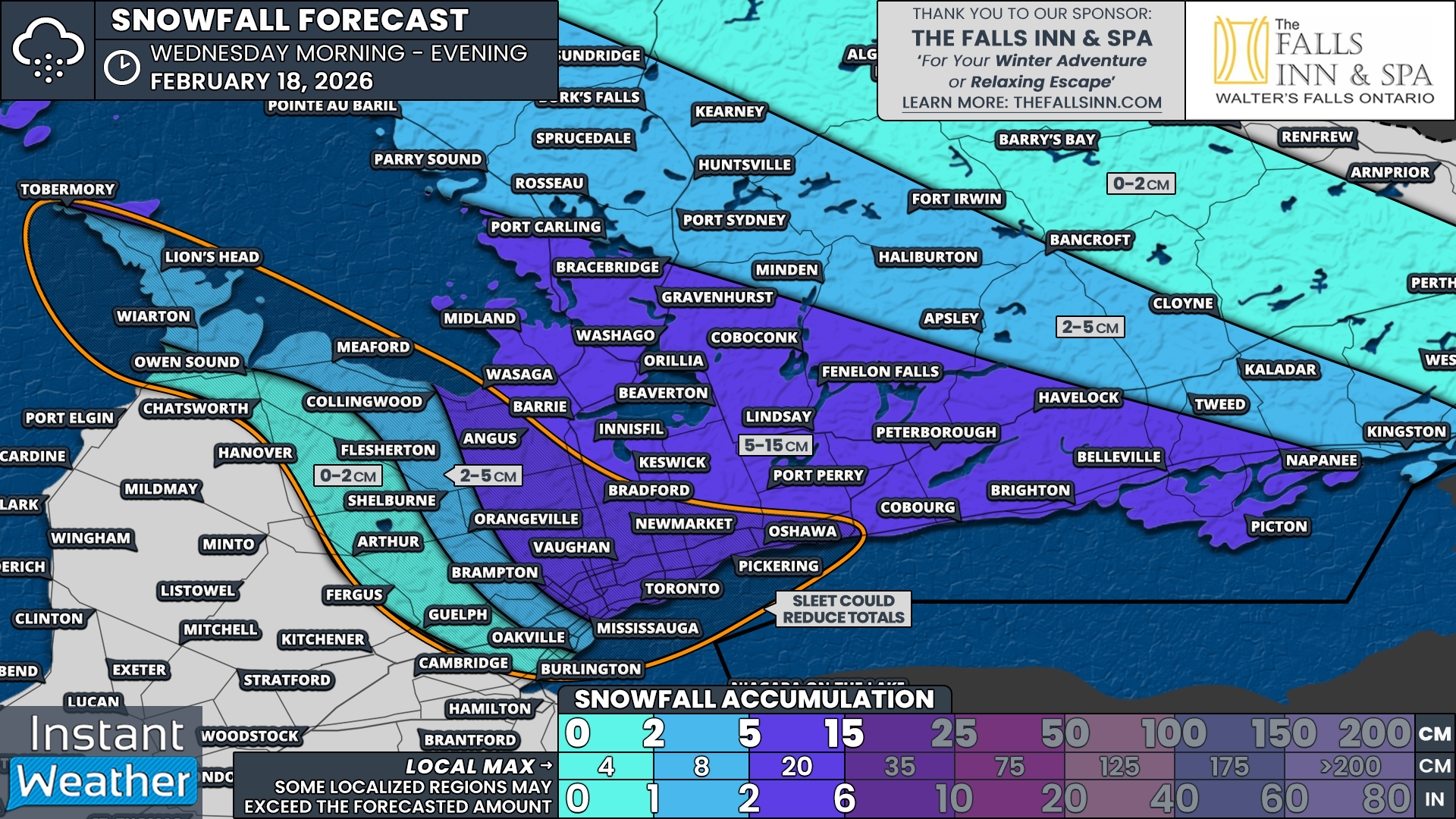
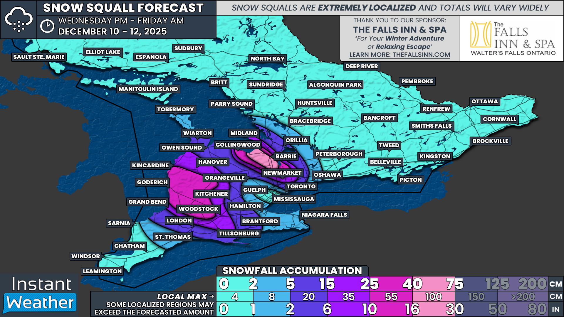
Snowfall totals of 25 to 50 cm are expected for the Bruce Peninsula, including Wiarton, Lions Head, and Tobermory, as well as areas east of Georgian Bay such as Bracebridge, Huntsville, and Parry Sound. Muskoka in particular has the potential to exceed 50 cm if the squall becomes stationary on Thursday.

Further south and east, areas such as Midland, Gravenhurst, Minden, Haliburton, and Bancroft can expect around 5 to 10 cm from the system, with an additional 10 to 15 cm from lake effect snow. This puts totals in the 15 to 25 cm range, with locally higher amounts possible.

Southern Grey-Bruce, extending into portions of Huron and Perth Counties, including Owen Sound, Meaford, Hanover, and Listowel, is also expected to end up in the 15 to 25 cm range by the time all is said and done.

High-Impact Snowstorm to Disrupt Thursday Morning Commute for Toronto, London, Ottawa and Eastern Ontario With Up to 20-40cm of Snow

NOTE: YOU CAN CLICK ON THE MAP TO OPEN A ZOOMABLE IMAGE

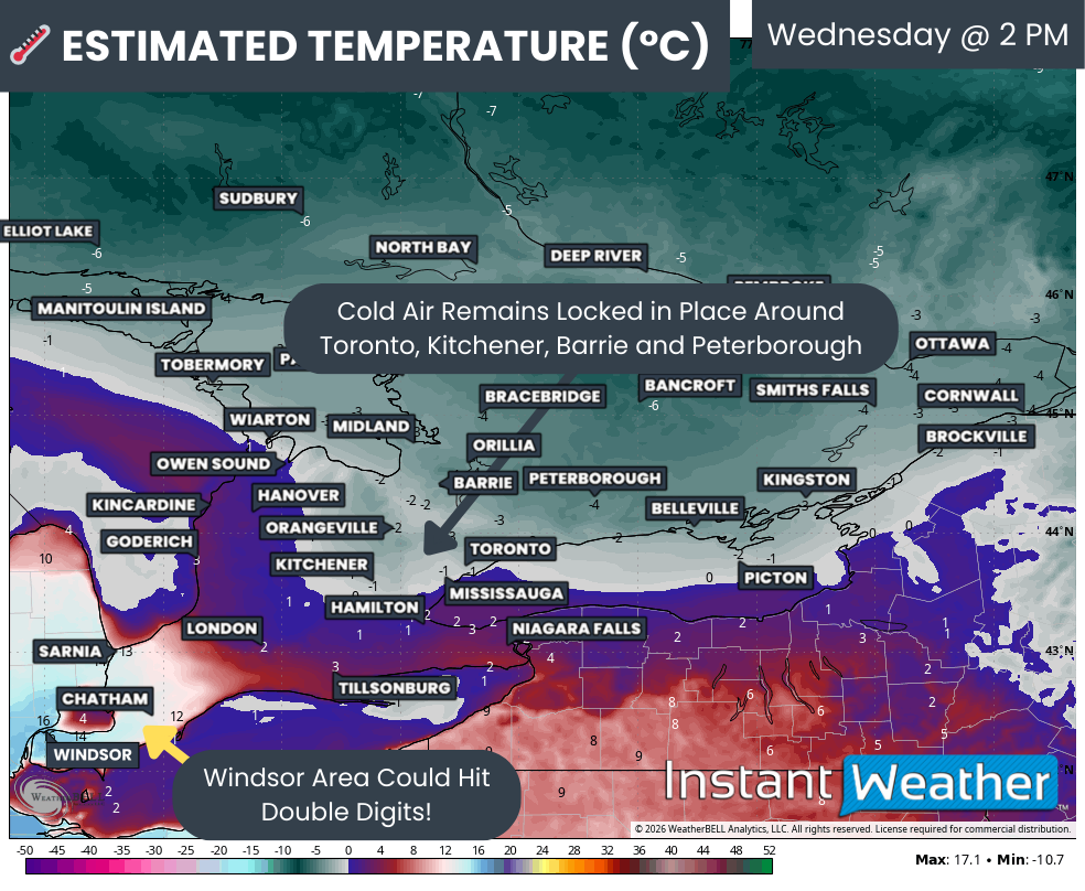
After a brief break from winter that allowed much of Southern Ontario to enjoy a bit of a so-called “January thaw”, it is becoming very clear that winter is far from finished. A sharp and notable cool down is now underway across the province, and by Thursday morning, temperatures will plunge well below seasonal levels.

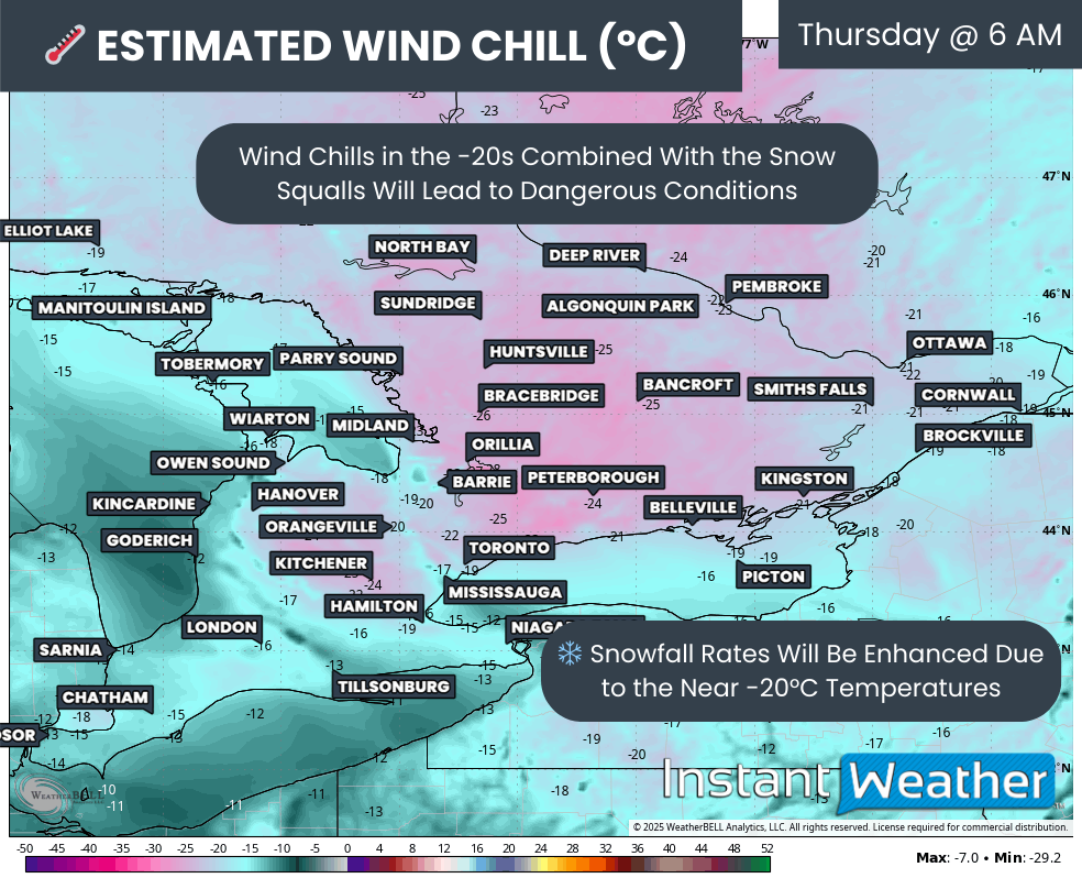
Many areas across Southern Ontario will see air temperatures drop to near or below -15°C, and when the wind is factored in, it could feel closer to -20°C to -30°C in some communities.

While the bitter cold will certainly be noticeable, it will not be the main story over the next 24 to 36 hours. Attention now turns to a developing winter storm that forecast models have struggled to resolve right up until the last minute. This system is expected to spread a broad swath of steady snowfall across much of Southern Ontario, with the potential for significant impacts in highly populated and heavily travelled regions.

Earlier forecasts suggested this would be a fairly routine winter event, with snowfall amounts in the 5 to 15 centimetre range for the hardest hit areas. That type of snowfall is very common this time of year and would have resulted in some slow travel, but nothing overly disruptive. However, the latest model runs have dramatically shifted, showing a much stronger and more organized storm system taking shape.

Over the past several model cycles, guidance has intensified considerably. We are now tracking what could become the most widespread and impactful snowfall event of the season so far for parts of Southern Ontario. Some areas may see snowfall totals that rival or exceed anything experienced so far this winter.

Based on the latest data, we are now forecasting widespread snowfall totals in the 20 to 40 centimetre range across a large corridor stretching from Southwestern Ontario through the Golden Horseshoe and into Eastern Ontario.

Snow has already begun in some areas and is expected to continue intensifying through Wednesday evening, persisting through much of the day on Thursday before finally tapering off later in the afternoon or early evening.

This higher impact zone covers a very large portion of the province, including some of the most densely populated regions. This alone raises concerns about travel disruptions, school and business impacts, and the potential for extended cleanup times once the snow finally ends.

In addition to the steady system snowfall, there is also the potential for snow squalls to become embedded within the system. These are most likely to develop south of Lake Huron, particularly overnight into Thursday morning. Areas between Sarnia and London, including Lambton County and parts of Chatham-Kent, could see enhanced snowfall rates as lake enhancement adds extra moisture to the system.

The worst travel conditions are expected to occur overnight and into Thursday morning. By the time many people wake up, there will already be a substantial amount of snow on the ground, with steady snowfall ongoing. This sets the stage for a very difficult Thursday morning commute across much of Southern Ontario.

If travel can be avoided in the hardest hit areas, especially during the morning and early afternoon hours on Thursday, it would be strongly advised. For those who must travel, expect significant delays, poor visibility at times, and rapidly deteriorating road conditions, particularly in urban areas that have not yet seen a snowfall of this magnitude this season.

While there is growing agreement among models that a major snowfall event is likely, confidence is still not especially high when it comes to the exact placement of the heaviest bands. The forecast remains volatile, with some models continuing to shift the storm track slightly north or south. This has created a very sharp snowfall gradient, meaning small changes in the storm’s position could result in big differences in totals over short distances.

In some cases, communities could see over 20 centimetres of snow, while locations just 30 or 40 kilometres away may see less than half of that. This makes pinpointing exact totals extremely challenging and increases the risk of some areas either underperforming or significantly exceeding the forecast.

Hourly snowfall rates (cm) - MAP FROM WEATHERBELL

Snow has already begun across Deep Southwestern Ontario and will continue spreading northeastward through the evening. By around midnight, snowfall should be widespread across much of Southwestern Ontario and expanding into the Golden Horseshoe, including the Niagara region and western GTA.

For many locations, snowfall will begin as steady and moderate, gradually increasing in intensity through the overnight hours. Snowfall rates will generally sit around 1 to 2 centimetres per hour initially, which on its own may not seem overly concerning. The issue is the duration of the event, as these rates will persist for 12 hours or more in some areas, allowing snow to pile up over time.

The heaviest snowfall overnight is expected to be focused between Sarnia and London, where lake enhancement off Lake Huron may briefly boost snowfall rates higher. These heavier bursts could make travel especially difficult overnight and into the early morning hours.

Wind will also become a factor as the storm progresses. Gusts will increase to between 40 and 60 kilometres per hour in some areas overnight. When combined with falling snow, this will lead to blowing snow and reduced visibility, particularly in open and rural areas.

Hourly snowfall rates (cm) - MAP FROM WEATHERBELL

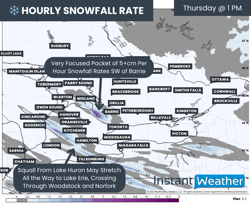
Conditions are expected to continue deteriorating into Thursday morning as snowfall intensity increases across much of the Golden Horseshoe. Areas from London through Hamilton and into the Greater Toronto Area could see periods of heavier snow during the morning hours. In the most intense bands, snowfall rates may briefly reach 2 to 4 centimetres per hour, which will make it very difficult for road crews to keep up.

Unfortunately, this lines up almost perfectly with the Thursday morning rush hour. Travel across the GTA and surrounding regions will be extremely slow, and in some cases nearly impossible, especially on secondary roads. If you can delay travel or work from home, Thursday morning would be an ideal time to do so.

Snow will also spread into Eastern Ontario overnight and early Thursday morning. The Ottawa area is expected to see snow arrive around or just before the morning commute, with conditions worsening through the late morning and early afternoon hours.

One of the most important details we are still watching closely is the northern cutoff of the heaviest snow. As shown on the forecast map, there is a sharp transition zone near areas such as Barrie and Peterborough. The American HRRR model suggests that locations just north of this line may see very little snow, while those south of it could see totals exceeding 20 centimetres.

Other model solutions shift this cutoff further south, which would place parts of the GTA closer to the lower snowfall edge. Meanwhile, some guidance shifts it further north, allowing areas like Barrie and Peterborough to see much higher totals. This uncertainty is why confidence drops significantly near this transition zone.

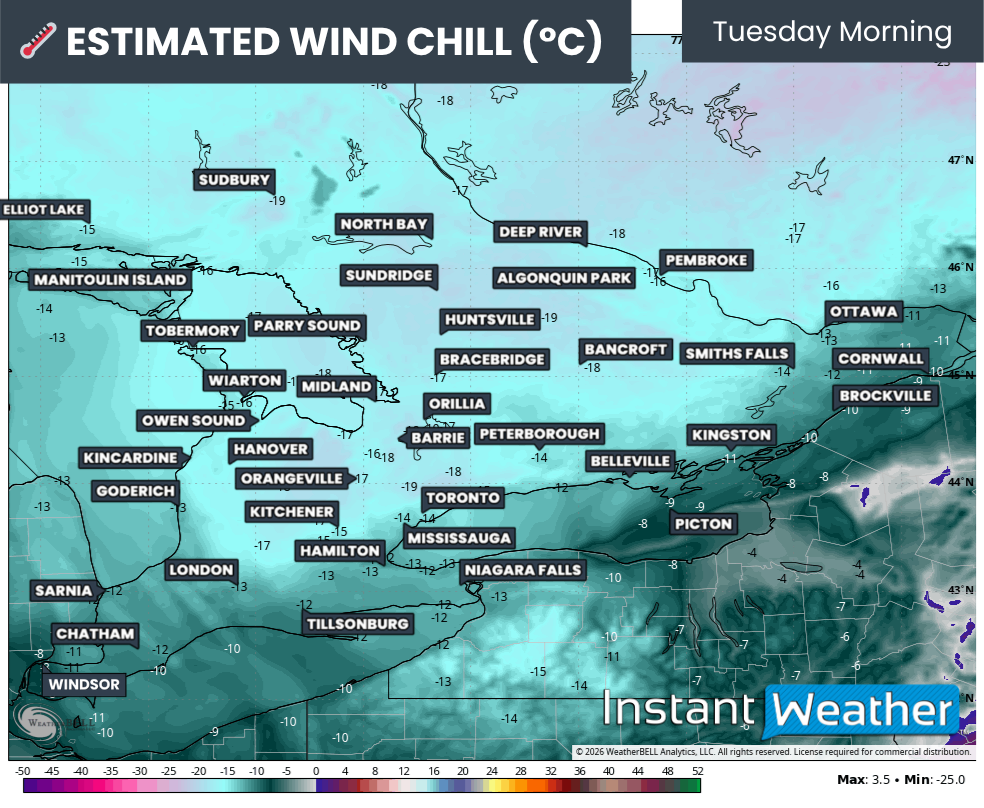
WIND CHILL - MAP FROM WEATHERBELL

Another key factor enhancing snowfall totals is the colder air moving in behind the system. By Thursday morning, many parts of Southern Ontario will feel like -20°C or colder once you factor in the wind chill.

As temperatures drop, the snow becomes lighter and fluffier. Colder air allows snowflakes to be less dense, which means the same amount of moisture can produce more snow on the ground. This is known as a higher snow-to-liquid ratio, and it is one reason totals may end up higher than initially expected.

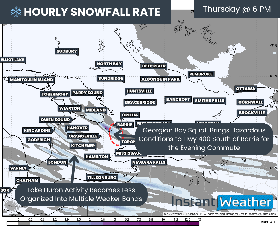
Hourly snowfall rates (cm) - MAP FROM WEATHERBELL

Through the late morning hours on Thursday, heavy snow is expected to continue across the Golden Horseshoe while spreading further east into Eastern Ontario.

In the west, areas near Lake Huron and Deep Southwestern Ontario should begin to see snowfall gradually taper off toward the end of the morning.

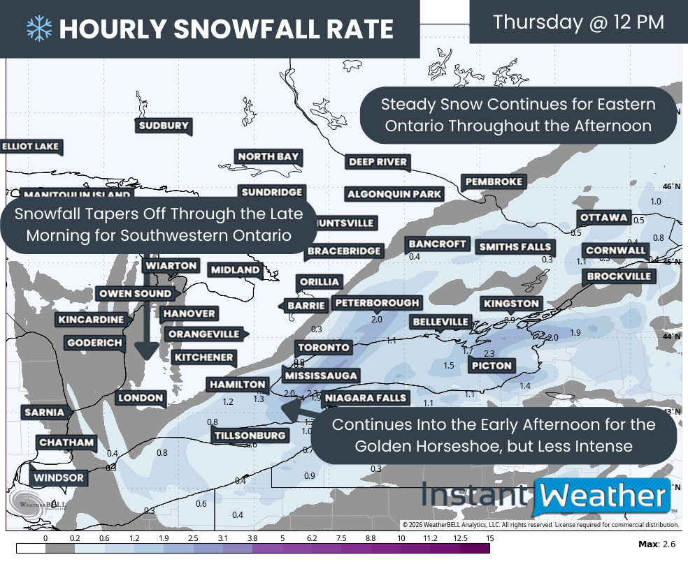
By around noon, steady snow should still be falling from the Golden Horseshoe eastward into Eastern Ontario. The Niagara region and eastern portions of the GTA may remain under heavier snowfall for the first part of the afternoon before intensity slowly begins to decrease.

Hourly snowfall rates (cm) - MAP FROM WEATHERBELL

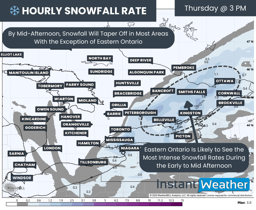
Eastern Ontario may end up seeing the worst conditions during the early to mid-afternoon hours. Snowfall rates here are expected to range between 1 and 3 centimetres per hour and could linger for several hours before tapering off later in the day.

Snow should finally begin to move out of most areas by late afternoon or early evening, though a few lingering flurries may persist into the evening across Eastern Ontario.

NOTE: YOU CAN CLICK ON THE MAP TO OPEN A ZOOMABLE IMAGE

The most challenging aspect of this storm remains the tight snowfall gradient. Small shifts in storm track will make a big difference in totals, and models continue to disagree on exactly where that cutoff will set up. This means forecast amounts could change with little notice.

After reviewing all available guidance, we have put together a snowfall forecast that reflects the most likely scenario based on the majority of model data. However, this is one of those events where nearly every model offers a slightly different outcome, and it would not take much for totals to shift in either direction.

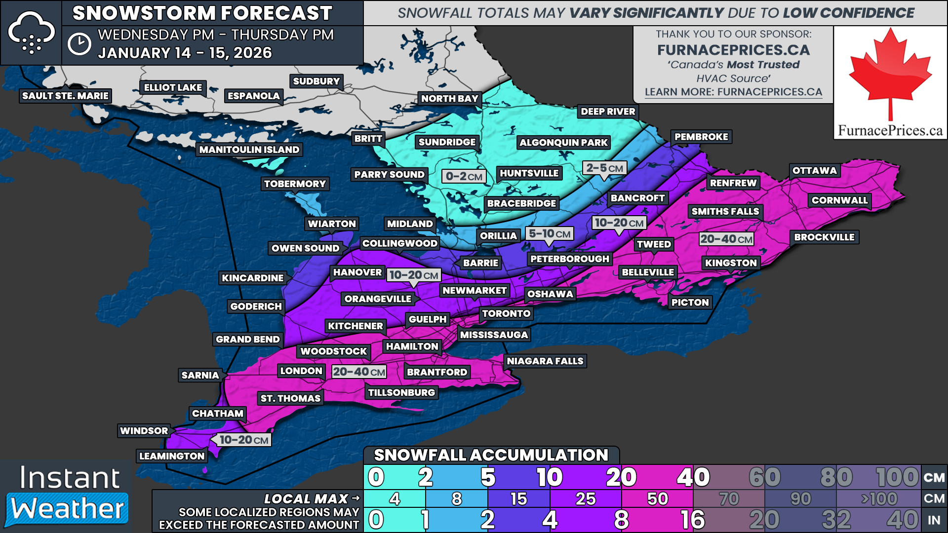
The highest snowfall totals appear most likely in a corridor stretching from Sarnia through London, across the entire Golden Horseshoe, and into Eastern Ontario, including the Ottawa Valley. These areas can expect widespread totals of 20 to 40 centimetres, with isolated pockets possibly approaching or exceeding 50 centimetres.

This includes communities such as Sarnia, Chatham, London, Woodstock, Tillsonburg, Brantford, Niagara Falls, Hamilton, Kitchener, Guelph, Mississauga, Toronto, Oshawa, Belleville, Tweed, Kingston, Smiths Falls, Renfrew, Ottawa, Brockville and Cornwall.

Slightly lower totals in the 10 to 20 centimetre range are expected for areas like Windsor, Leamington, Grand Bend, Goderich, Hanover, Orangeville, Newmarket, Peterborough and Bancroft. This is also the zone with the lowest confidence, as some of these locations could end up with significantly more or less snow depending on where the cutoff ultimately sets up.

Further north and west, snowfall amounts drop off quickly. Areas such as Owen Sound, Barrie and Pembroke are expected to see less than 10 centimetres of accumulation, with little to no snowfall expected north of Orillia.

These totals remain subject to change, and adjustments are likely as the storm unfolds. We will be closely monitoring conditions throughout Thursday and will provide real-time updates as we see how the storm is evolving on radar and through observations.

Southern Ontario Faces Ice Threat Then Snow as Fast Moving Winter System Disrupts Tuesday Travel

NOTE: YOU CAN CLICK ON THE MAP TO OPEN A ZOOMABLE IMAGE

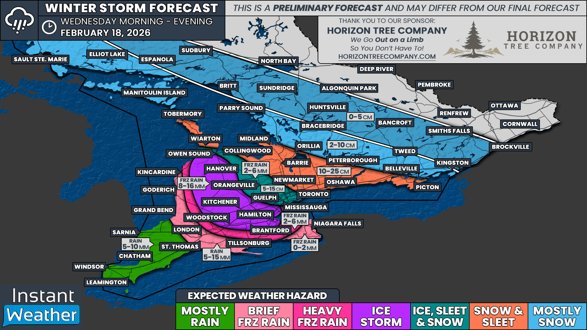
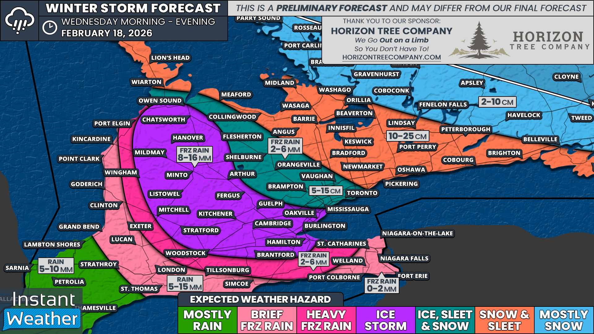
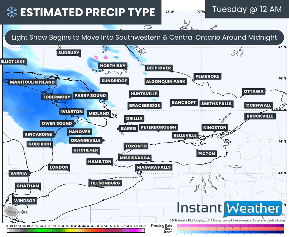
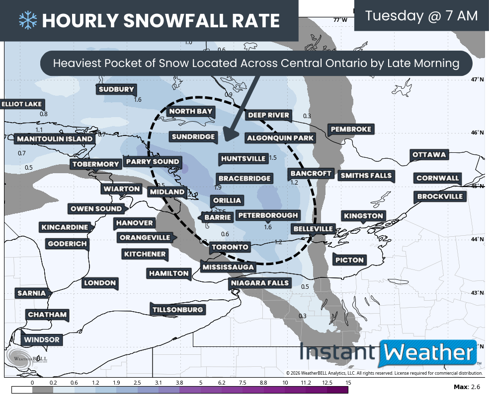
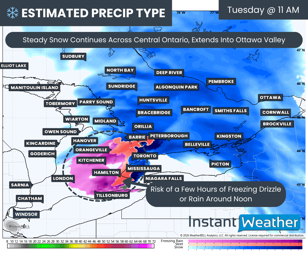
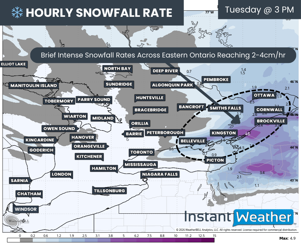
A fast changing winter system is expected to sweep through much of Southern Ontario during the day on Tuesday, bringing a messy mix of precipitation types and rapidly changing conditions. While this is not expected to be a blockbuster storm on its own, the combination of freezing rain followed by snow could still create localized impacts, especially during the afternoon and evening hours.

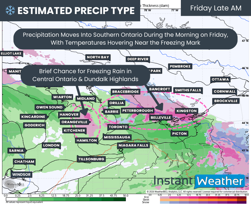
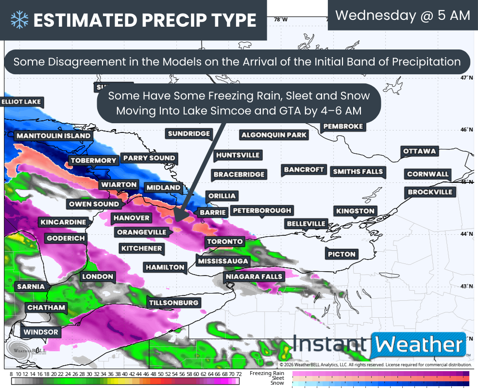
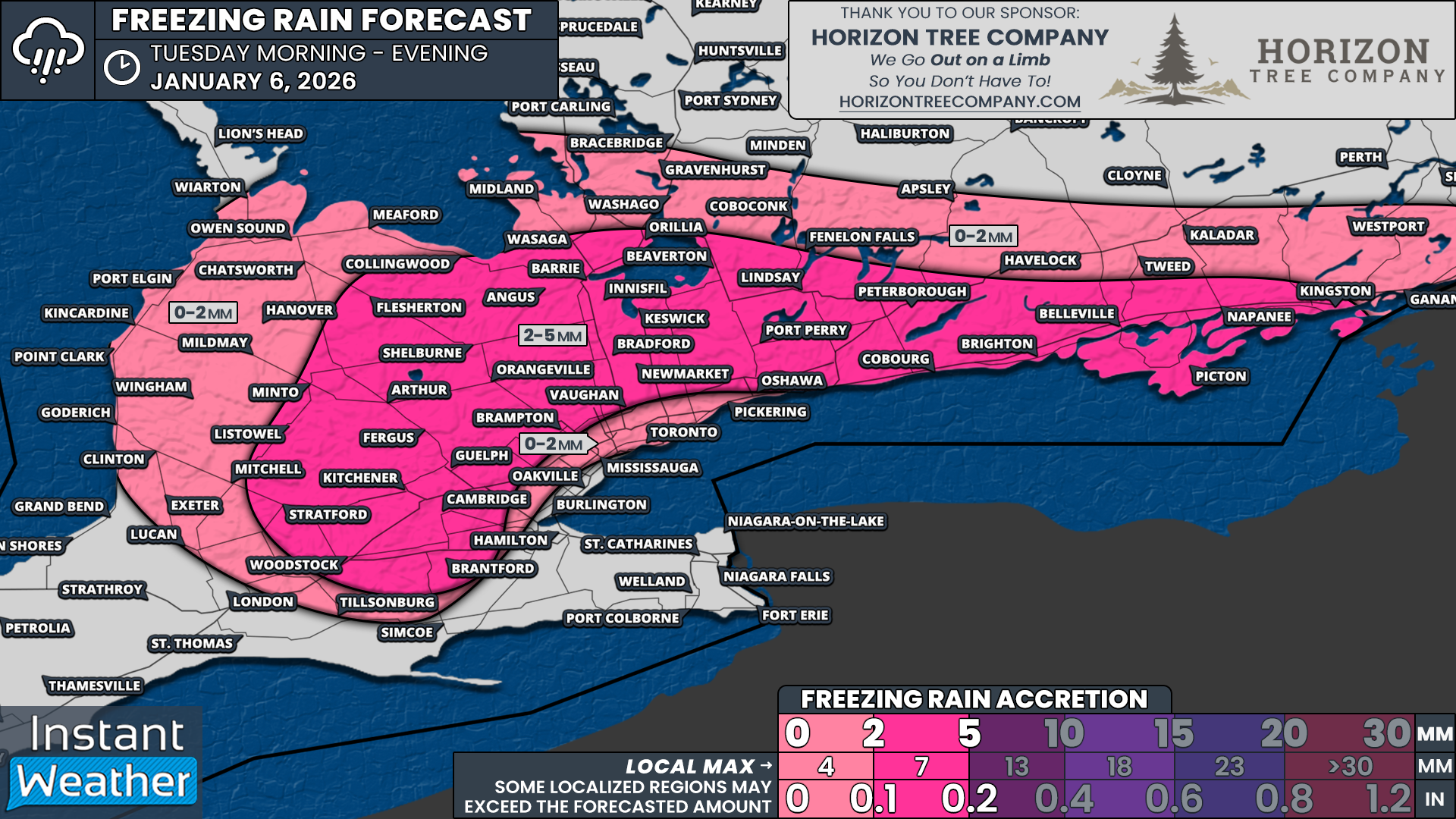
The first part of this system will arrive Tuesday morning and early afternoon, with freezing rain becoming the dominant concern for several regions. Widespread freezing rain is expected to develop across the higher elevations northwest of the GTA, extending into areas north of Lake Simcoe and along the Lake Ontario shoreline from Peterborough eastward toward Kingston. These elevated regions tend to hang onto colder air longer, making them more vulnerable to icing during marginal setups like this one.

Freezing rain is expected to begin developing across parts of Southwestern Ontario east of Lake Huron, including the Kitchener area and the Dundalk Highlands, by the late morning hours on Tuesday. From there, the freezing rain shield is forecast to spread north and eastward through the afternoon, reaching areas around Lake Simcoe such as Barrie, along with York Region, Durham Region, Kawartha Lakes, Peterborough and eventually Kingston.

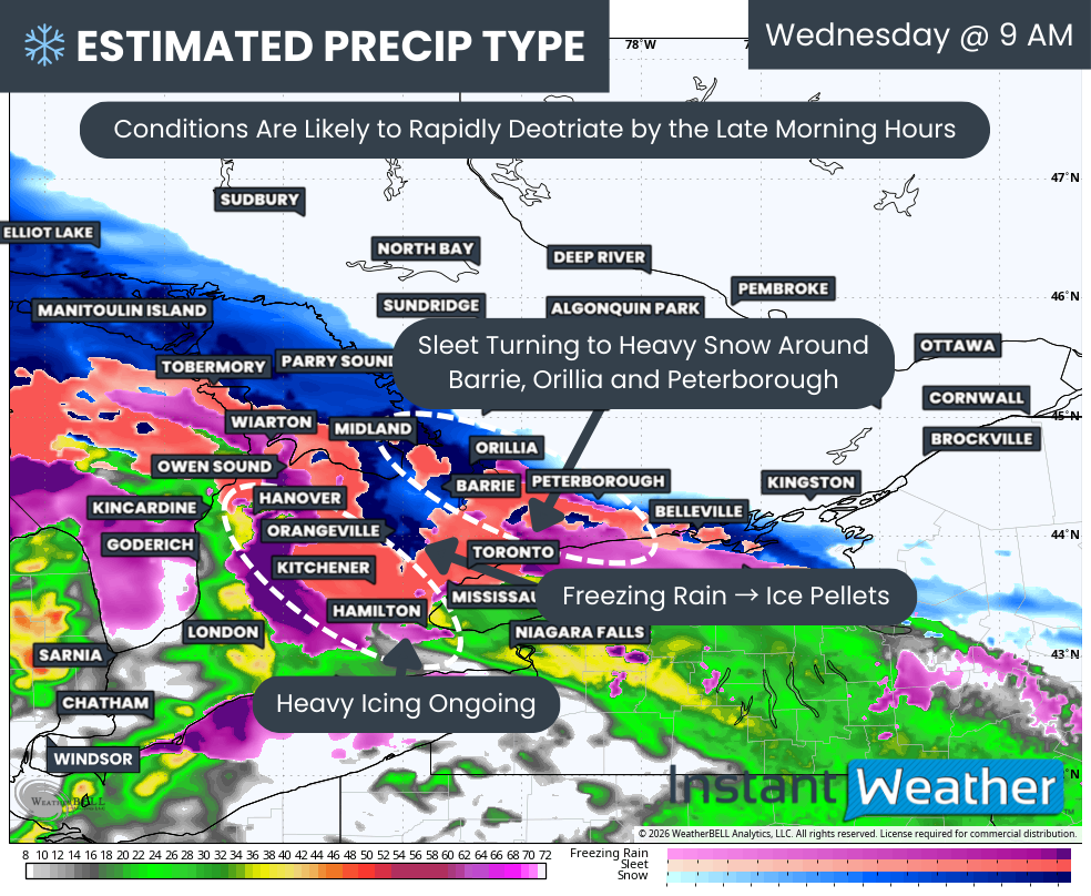
In some locations, the precipitation may initially fall as ice pellets during the early afternoon before transitioning over to freezing rain for a few hours. This could help slightly limit ice accretion at first, but any freezing rain will still make untreated roads, sidewalks and elevated surfaces quite slick as temperatures remain near or below freezing.

For the GTA, the freezing rain threat looks more limited, but it cannot be ruled out entirely. There could be an hour or two of freezing rain during the afternoon, especially in the northern parts of the region, before precipitation transitions over to light snow by the evening. Meanwhile, areas in Deep Southwestern Ontario and the Niagara region are expected to remain mostly on the rain side of this system, with temperatures hovering in the low single digits above freezing for much of the event.

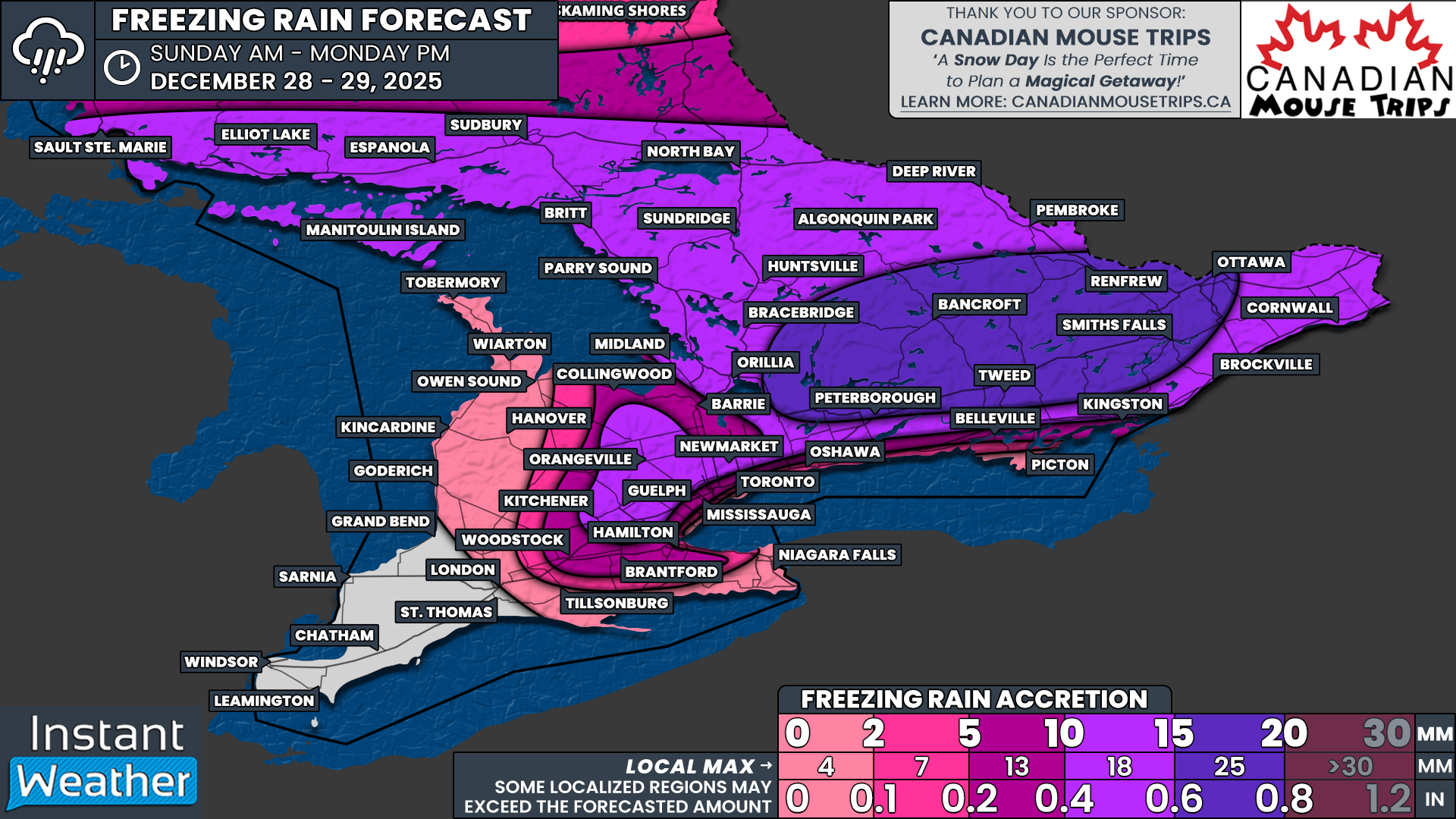
One of the more unusual aspects of this system is what happens after the freezing rain ends. While ice accretion amounts are expected to generally remain manageable, in the range of 2 to 5 millimetres for areas northwest of the GTA into Simcoe County and eastward through Peterborough and Kingston, there will not be a quick or clean warm-up. Instead, colder air is expected to surge back in, overpowering the warm layer aloft.

NOTE: YOU CAN CLICK ON THE MAP TO OPEN A ZOOMABLE IMAGE

As this colder air deepens, precipitation is forecast to transition back to snow by the early evening and continue into the overnight hours across Central and Eastern Ontario, as well as the higher elevations northwest of the GTA. This changeover could happen fairly quickly once it begins, leading to periods of steady snowfall through Tuesday night.

Snowfall totals from this second phase of the system are expected to range from 5 to 10 centimetres across many of the same areas that experienced freezing rain earlier in the day. This includes parts of Simcoe County, Kawartha Lakes, Peterborough and areas toward Kingston, as well as elevated terrain northwest of the GTA.

While neither the ice accretion nor the snowfall amounts are particularly extreme on their own, the combined impact could be more significant. Even light ice accretion can weaken tree branches and add extra weight to power lines, and when followed by several centimetres of heavy, wet snow, the risk of isolated power outages and downed branches increases.

Elsewhere, including the GTA, regions east of Lake Huron and parts of northern Central and Eastern Ontario, snowfall totals are expected to be lighter, generally in the 2 to 5 centimetre range. This should still be enough to create slick travel conditions Tuesday evening and overnight, especially as temperatures drop back below freezing.

For the Ottawa region, this system looks less impressive overall. Precipitation amounts appear limited, and snowfall totals may struggle to reach the 2 centimetre mark by the time everything wraps up.

As always with systems like this, small changes in temperature can make a big difference in precipitation type and impacts. Drivers should be prepared for rapidly changing road conditions throughout the day on Tuesday, especially in areas that see freezing rain followed by accumulating snow.

End-of-Year Major Winter Storm to Bring Dangerous Ice Storm and Blizzard Conditions Across Southern and Northeastern Ontario Starting Sunday

Use Promo Code ‘Instant’ to Receive a Min. $25 Gift Card With Your Vacation!

NOTE: YOU CAN CLICK ON THE MAP TO OPEN A ZOOMABLE IMAGE

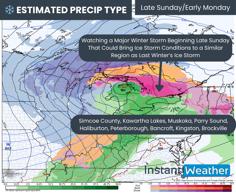
As we close out 2025, the final few days are shaping up to be very messy and potentially dangerous. A complex and powerful winter storm is expected to impact Ontario between Sunday and Monday, bringing ice storm conditions to a wide swath of Central, Eastern and Northeastern Ontario.

With significant and prolonged freezing rain expected, widespread and long-lasting power outages are likely in the hardest hit areas. Ice accretion of up to 20mm is possible, and unfortunately, the regions most at risk include many of the same areas that were hit hard by last March’s major ice storm. In some locations, the power grid remains fragile, which raises additional concern.

Further north, the story will shift to heavy snow across much of Northeastern Ontario. Long-lasting blizzard conditions are possible here, with snowfall totals potentially exceeding 50cm by the time the storm finally winds down on Tuesday.

This system will also bring the risk of severe wind gusts across both Southern and Northern Ontario on Monday. Areas closest to the shorelines of the Great Lakes will be at the greatest risk, with damaging wind gusts in excess of 90 km/h possible. There may even be some isolated pockets, mainly in the Niagara region, that approach 100 km/h.

Southwestern Ontario will be largely unaffected by the first phase of the storm. Temperatures here will rise steadily on Sunday, peaking in the double digits by late afternoon or evening. Rain will fall steadily through Sunday and into early Monday. However, conditions will change rapidly as temperatures plunge Monday morning, creating a potential flash freeze as all that rainfall quickly freezes on roads and other surfaces.

Later on Monday, strong wind gusts will combine with steady, moderate snowfall around Lake Huron and Georgian Bay. Blizzard conditions could develop during the afternoon and evening as visibility drops and blowing snow becomes intense.

PRECIP TYPE - MAP FROM WEATHERBELL

The storm will begin to take shape late Sunday morning as the first bands of precipitation spread into Northeastern Ontario and parts of Southwestern Ontario. This will initially include some light freezing rain extending from London through Kitchener and Barrie.

TEMPERATURE - MAP FROM WEATHERBELL

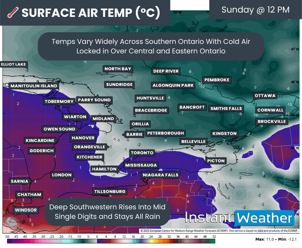
Sunday afternoon will be heavily dependent on the position of the freezing line, which is expected to slowly expand northeastward. Areas to the southwest will gradually climb above freezing and escape the worst of the icing, while regions farther northeast remain locked below zero.

By around midday, most of Central and Eastern Ontario is expected to remain well below freezing. Higher elevation areas northwest of the GTA will hover close to the freezing mark, including Hamilton, Kitchener, Guelph and Orangeville. How long the cold air remains trapped at the surface will play a major role in how impactful the icing becomes in places like the Kitchener area.

Meanwhile, Deep Southwestern Ontario, including Windsor, will already be sitting in the mid single digits. Heavy rain will be ongoing here, but there will be no winter storm impacts during the day on Sunday.

PRECIP TYPE - MAP FROM WEATHERBELL

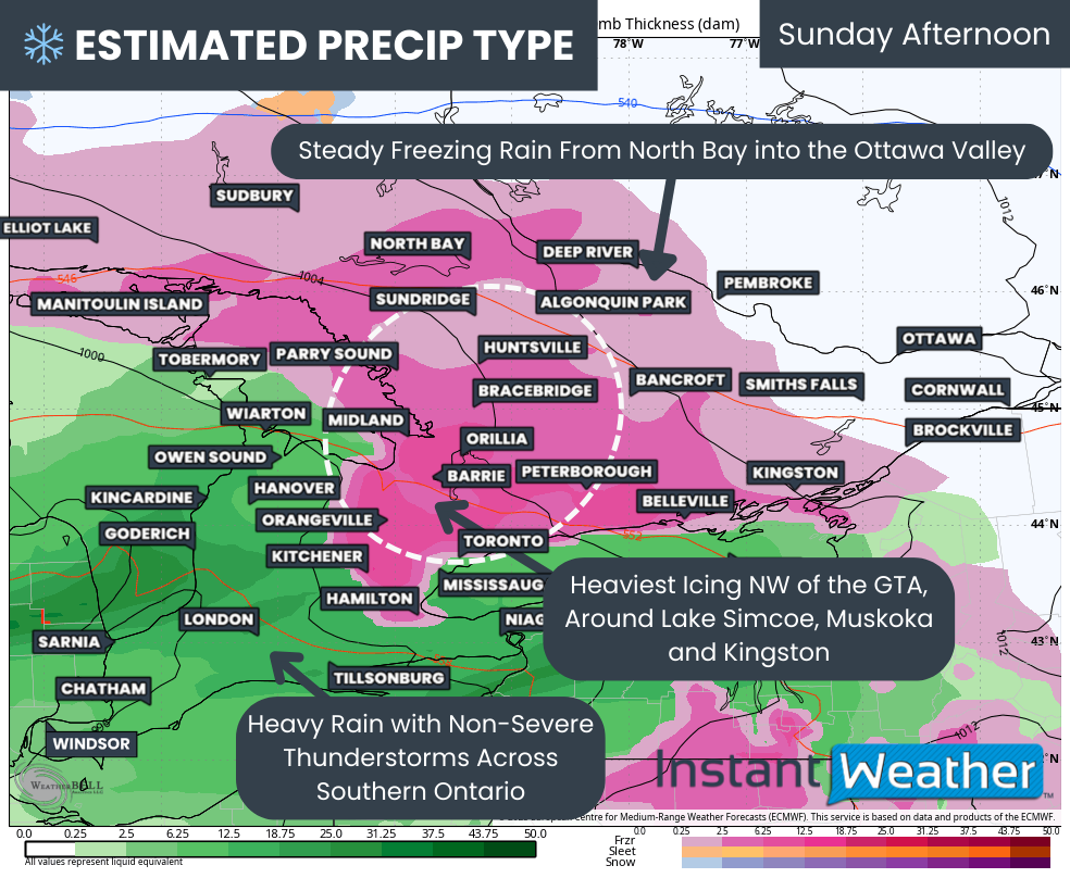
As Sunday afternoon progresses, the freezing rain shield will expand northward into the North Bay area and the Ottawa Valley. The heaviest icing during this time is expected to focus around Lake Simcoe.

Locations such as Bracebridge, Lindsay, Orillia, Peterborough, Barrie, York Region, Kitchener and Orangeville appear likely to see the worst icing on Sunday afternoon. Precipitation rates will be quite heavy, allowing ice to accumulate rapidly on roads, trees and power lines.

At the same time, Southwestern Ontario, including the Niagara region, will see heavy rain, with some embedded non-severe thunderstorms possible. Rainfall totals could be significant, with some localized areas exceeding 50mm by Monday morning.

At the same time, Southwestern Ontario, including the Niagara region, will see heavy rain, with some embedded non-severe thunderstorms possible. Rainfall totals could be significant, with some localized areas exceeding 50mm by Monday morning.

Flooding could be a concern as frozen ground has a lower ability to absorb the rain.

PRECIP TYPE - MAP FROM WEATHERBELL

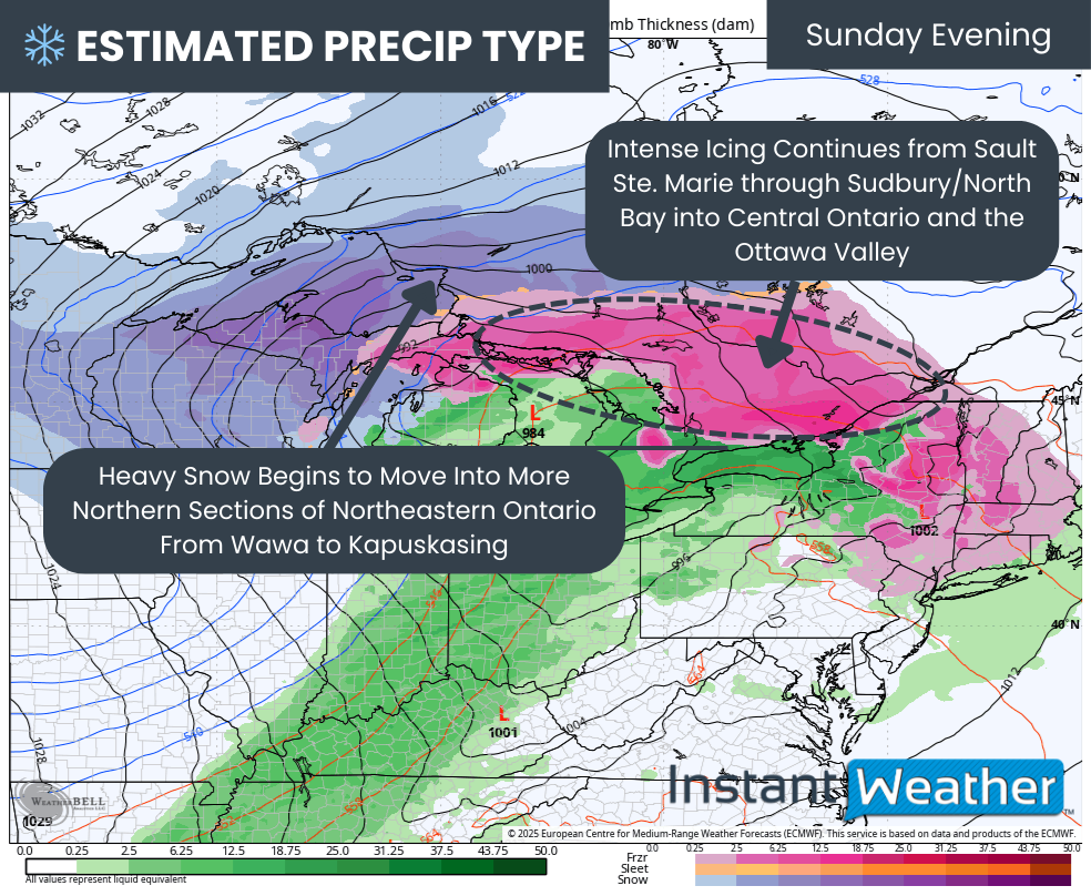
As we move into Sunday evening, the freezing rain zone will become very expansive as the system rapidly intensifies. Intense icing is expected from Sault Ste. Marie through Sudbury and North Bay and into Central and Eastern Ontario.

Meanwhile, colder and more entrenched air across Northeastern Ontario will allow precipitation to switch over to heavy snow. Areas from Wawa to Kapuskasing will see snowfall rates increase significantly.

TEMPERATURE - MAP FROM WEATHERBELL

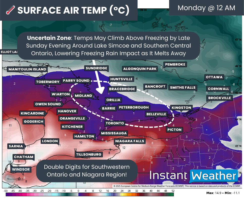
By late Sunday evening, uncertainty will increase across southern portions of Central and Eastern Ontario as temperatures hover very close to the freezing mark. This includes Barrie, Orillia, Muskoka, the Kawarthas, Peterborough and Kingston. If cold air proves even slightly more resilient than currently expected, these regions could remain below freezing overnight and continue to experience ice storm conditions.

In Deep Southwestern Ontario, it will feel almost surreal for late December, with temperatures climbing into the double digits even around midnight.

PRECIP TYPE - MAP FROM WEATHERBELL

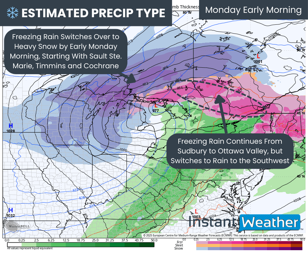
Overnight Sunday into early Monday, heavy snowfall will expand farther south across Northeastern Ontario as colder air continues to advance. Areas including Sault Ste. Marie, Timmins and the Cochrane corridor are expected to transition from freezing rain to heavy snow.

This transition is especially concerning for the power grid, as heavy snow may accumulate on top of ice-coated trees and power lines. That combination could lead to significant damage, particularly in more remote and heavily forested areas.

For the Sudbury to Ottawa Valley corridor, freezing rain is expected to continue through the overnight hours with ice accumulation steadily increasing. This region is likely to see some of the worst overall impacts due to the length of time spent under freezing rain.

TEMPERATURE - MAP FROM WEATHERBELL

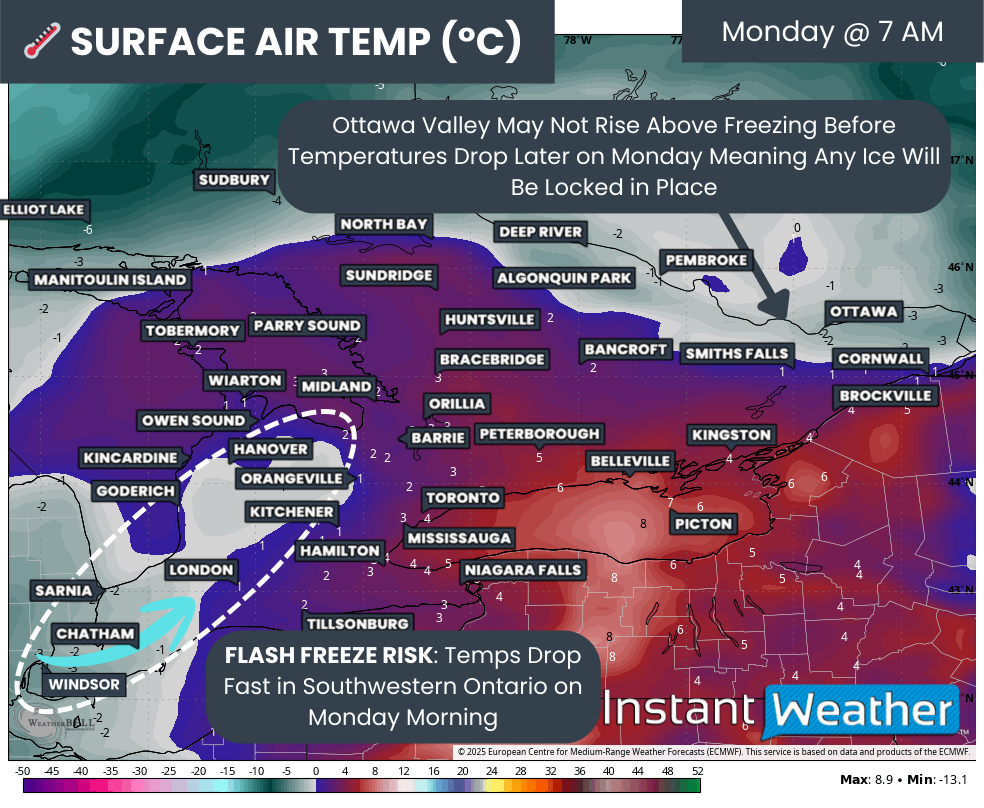
By late Monday morning, the next phase of the storm will unfold in the form of a flash freeze across Deep Southwestern Ontario. Rapidly falling temperatures will cause any remaining moisture to freeze quickly on untreated surfaces, creating extremely hazardous travel conditions.

NOTE: YOU CAN CLICK ON THE MAP TO OPEN A ZOOMABLE IMAGE

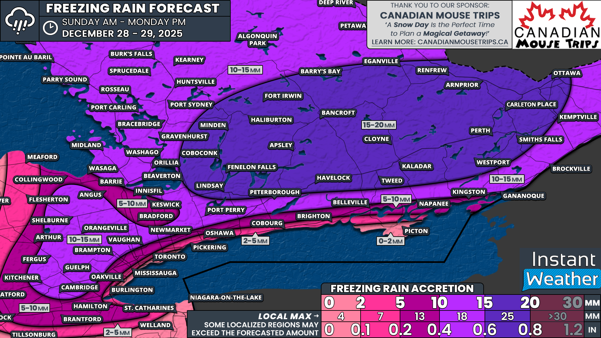
As freezing rain ends across Central and Eastern Ontario and temperatures drop by Monday afternoon, the true extent of the damage will become clear. Current data suggests the hardest hit areas may include Kawartha Lakes, Peterborough, Haliburton, Bancroft, Tweed, Kaladar, Renfrew, Perth and Ottawa. Ice accretion in these regions may range from 15 to 20mm, with localized pockets potentially approaching 25mm.

In the Ottawa Valley, temperatures may not rise above freezing at all before the flash freeze arrives. This would lock ice in place for an extended period, worsening impacts. Farther south, a brief window above freezing may help slightly reduce overall damage.

A broader area of Central and Eastern Ontario, along with higher elevations northwest of the GTA and parts of Northeastern Ontario, can expect between 10 and 15mm of ice. This includes Brockville, Kitchener, Guelph, Newmarket, Barrie, Muskoka, Parry Sound, North Bay, Sudbury and Sault Ste. Marie.

Ice amounts will decrease closer to Lake Ontario and away from higher terrain. Between 5 and 10mm is possible from Kingston through the northern GTA and higher elevations around Hamilton and Grimsby. Less than 5mm is expected for Oshawa, Mississauga, Hamilton and Meaford. Little to no icing is expected near Lake Huron and Lake Ontario, where temperatures remain above freezing for most of the event.

PRECIP TYPE - MAP FROM WEATHERBELL

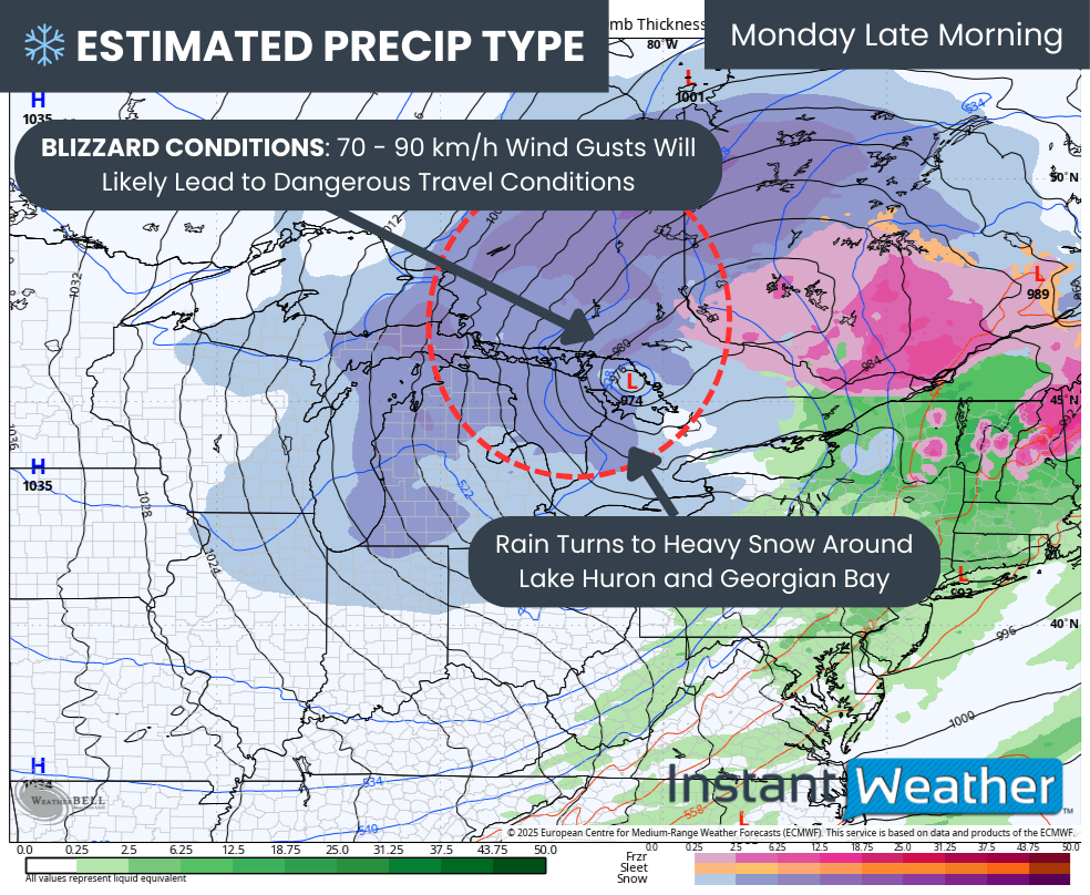
While freezing rain will end, hazardous conditions will continue. By late Monday morning, rain will change to heavy snow around Lake Huron and Georgian Bay. Strengthening winds of 70 to 90 km/h will create dangerous travel conditions and likely meet blizzard criteria.

Combined with the flash freeze, widespread road closures are likely east of Lake Huron and into Northeastern Ontario. Travel should be avoided in these regions.

NOTE: YOU CAN CLICK ON THE MAP TO OPEN A ZOOMABLE IMAGE

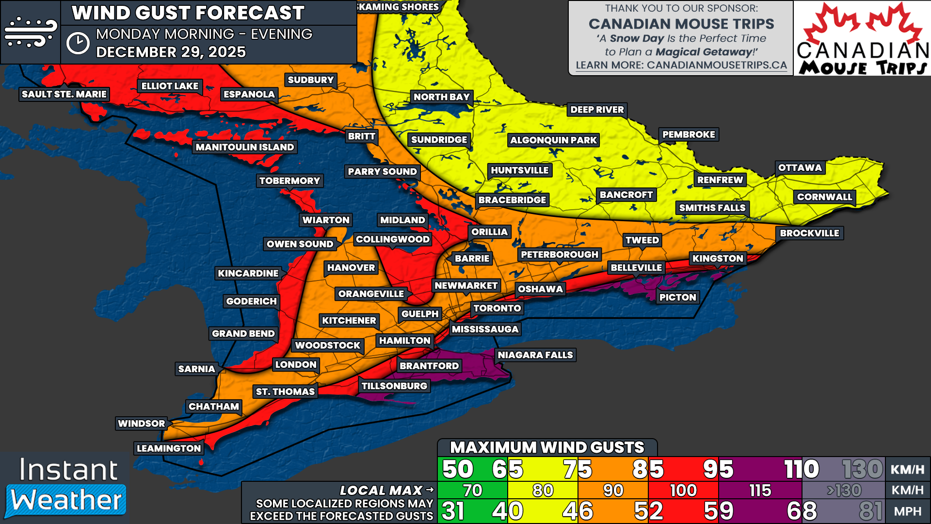
The strongest wind gusts are expected during the morning and afternoon on Monday before slowly easing in the evening. Areas exposed to the lakes will see the worst winds, with gusts of 95 to 110 km/h possible across the Niagara region and into Prince Edward County.

Near damaging gusts of 85 to 95 km/h are possible along the Lake Ontario shoreline from Kingston through the GTA and Hamilton, as well as along the Lake Erie and Lake Huron shorelines and southeast of Georgian Bay into Simcoe County and Orangeville.

Elsewhere across Southwestern Ontario and southern portions of Central and Eastern Ontario, peak gusts of 75 to 85 km/h are expected. Farther north, including the Ottawa Valley, gusts will generally range from 65 to 75 km/h. While lower, these winds may cause greater damage due to occurring after significant ice accumulation.

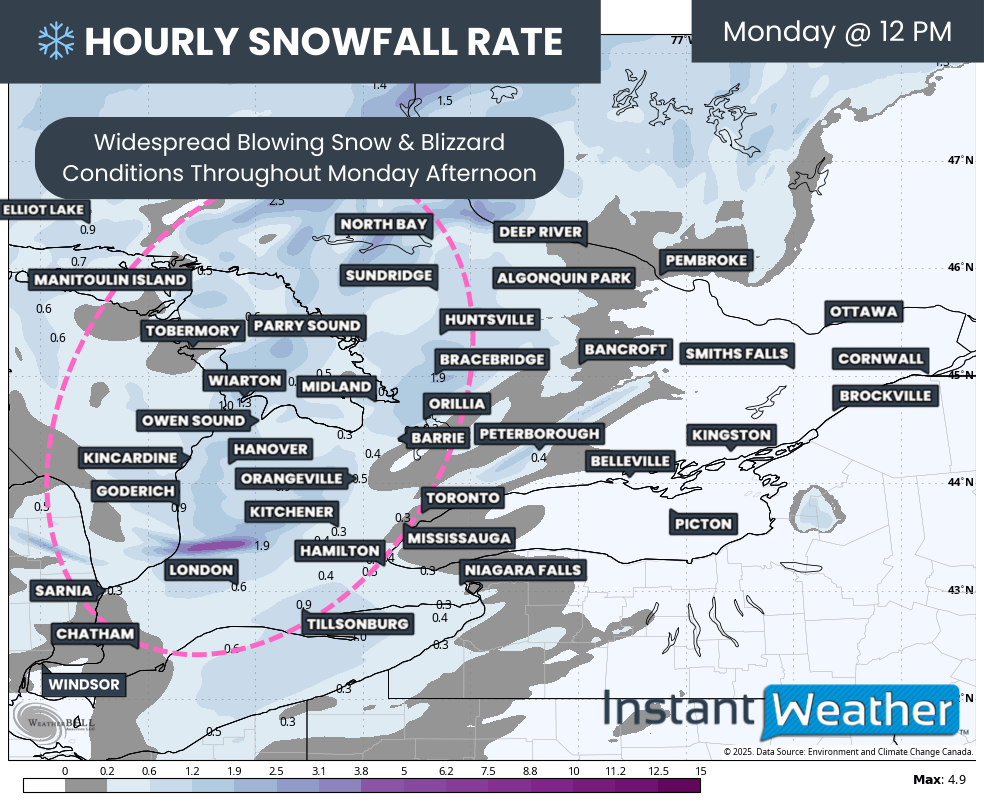
Hourly snowfall rates (cm) - MAP FROM WEATHERBELL

Conditions will remain treacherous through Monday afternoon with strong winds and persistent snowfall, especially near the lakes, where blizzard conditions continue.

NOTE: YOU CAN CLICK ON THE MAP TO OPEN A ZOOMABLE IMAGE

Snowfall totals associated with the main system will wrap up by Tuesday morning. Central Ontario and parts of Southwestern Ontario east of Lake Huron can expect 5 to 15cm of snow, with localized totals exceeding 15cm near Kincardine, Hanover and Owen Sound due to lake enhancement.

Elsewhere across Southern Ontario, snowfall amounts will generally range from 2 to 5cm.

NOTE: YOU CAN CLICK ON THE MAP TO OPEN A ZOOMABLE IMAGE

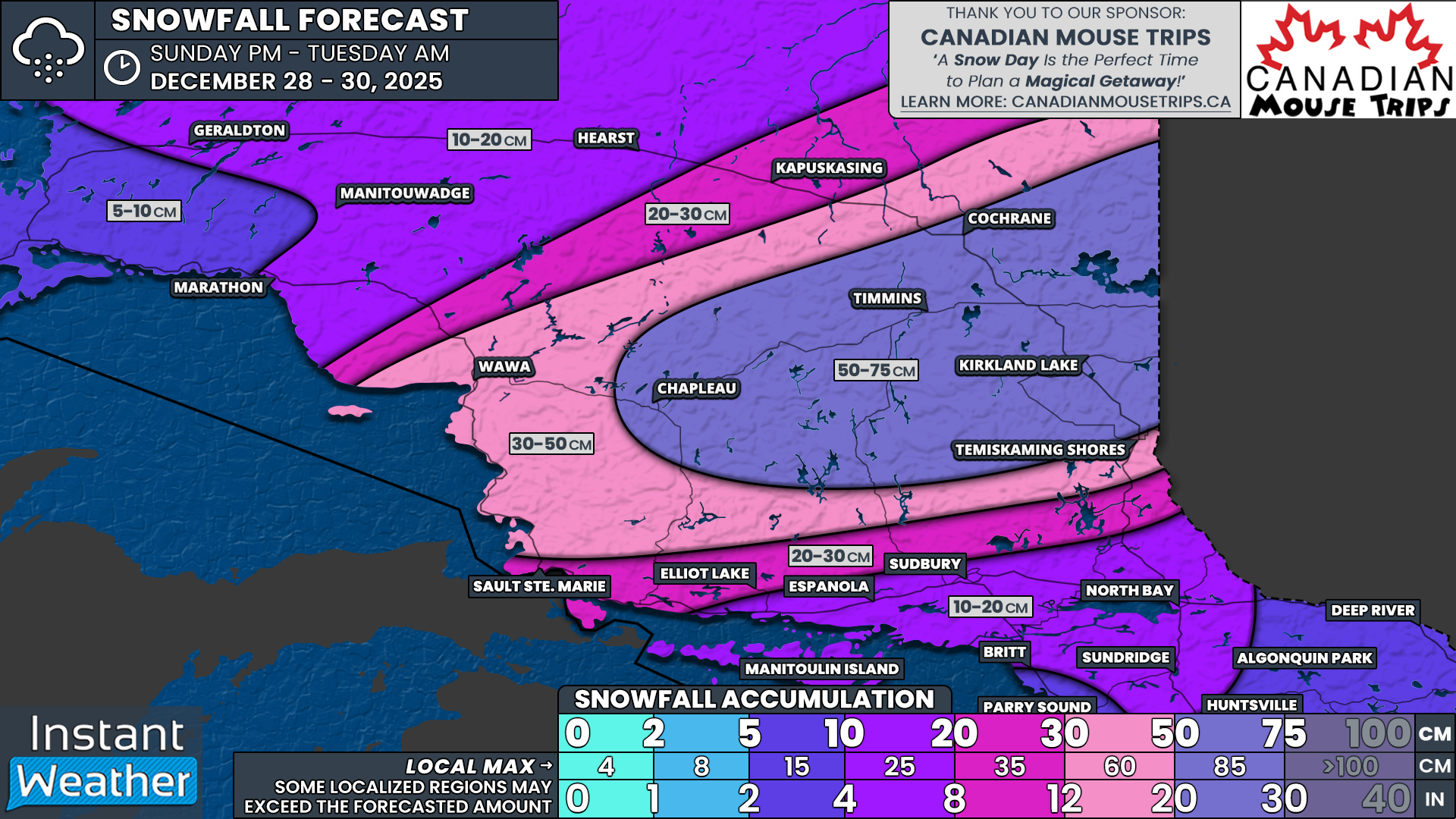
In Northern Ontario, snowfall totals will be far more significant. The highest amounts are expected in Cochrane, Timmins, Chapleau and Kirkland Lake, where totals of 50 to 75cm are possible between Sunday evening and Tuesday morning.

A broader swath of Northeastern Ontario, including Wawa and Temiskaming Shores, may see 30 to 50cm. Areas such as Elliot Lake, Sault Ste. Marie and Kapuskasing could receive 20 to 30cm, while North Bay, Sudbury and Manitoulin Island are expected to pick up between 10 and 20cm.

Boxing Day Winter Storm Poised to Deliver Ice Storm Risk and Heavy Snow to Southern Ontario on Friday

NOTE: YOU CAN CLICK ON THE MAP TO OPEN A ZOOMABLE IMAGE

With Christmas now behind us, the focus turns to the final stretch of 2025 as we approach New Year’s next Thursday. And it’s looking like the last seven days of the year will be anything but quiet when it comes to the weather across Southern Ontario.

That active pattern becomes clear very quickly with a looming Boxing Day winter storm expected to bring a messy mix of precipitation. Some areas will see periods of heavy snowfall, while others could be dealing with a potentially damaging ice storm with prolonged freezing rain through much of the day.

For much of Central Ontario, along with parts of the Golden Horseshoe and into portions of Southeastern Ontario, the primary concern will be snowfall. Widespread totals in the 10 to 20 cm range are possible by the end of Friday. The Ottawa Valley is expected to remain on the lower end, generally staying under the 10 cm mark.

The forecast becomes more complicated through Southwestern Ontario, extending through Hamilton and into the Niagara Region. Here, a mix of snow and ice pellets is expected, which will limit snowfall totals but still create hazardous travel conditions.

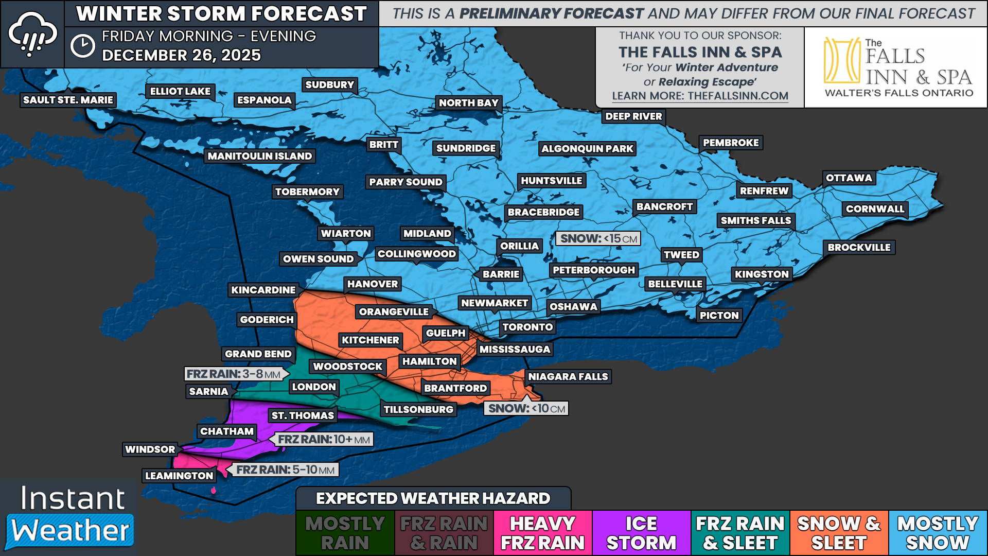
The freezing rain risk has shifted slightly northward in the latest model guidance, as warmer air aloft is now expected to push deeper into Southern Ontario than earlier projections suggested. This places the Sarnia to London corridor in the bullseye for the highest ice accretion. Freezing rain totals of 10 to 15 mm are possible, which could result in significant power outages and very icy road conditions.

Beyond Friday, attention is already turning to another slow-moving system expected to arrive Sunday and linger into Monday. This system appears to have access to much more moisture compared to Friday’s storm, raising the concern for a prolonged period of freezing rain that could last anywhere from 12 to 24 hours.

What adds to the concern is that current model guidance is focusing this next threat over parts of Central and Eastern Ontario, the same areas that were hardest hit by last winter’s major ice storm. There is still uncertainty with the exact track, and it could shift north or south, but it is something we are watching very closely.

PRECIP TYPE - MAP FROM WEATHERBELL

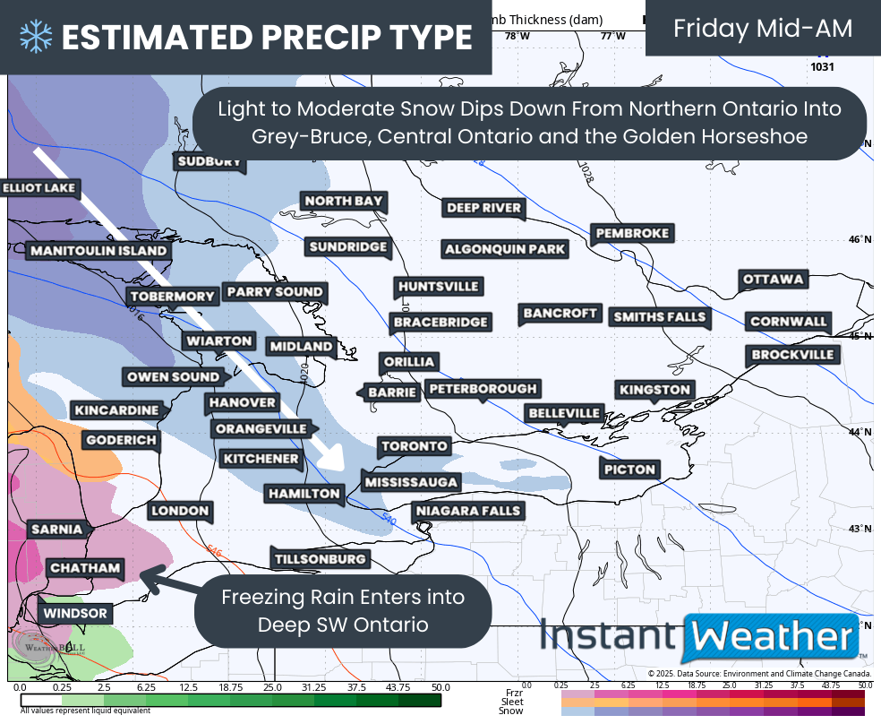
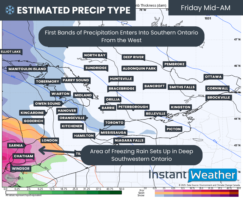
Before we get ahead of ourselves, the immediate focus remains on Friday’s storm. Precipitation is expected to begin during the early to mid-morning hours as bands move in from the west. Light to moderate snow will spread into Grey-Bruce, Simcoe County, Muskoka and the GTA during this time.

For Windsor, Chatham and Sarnia, light freezing rain is expected to begin by mid-morning. Precipitation may be somewhat scattered at first but will steadily increase in coverage and intensity as the morning progresses.

PRECIP TYPE - MAP FROM WEATHERBELL

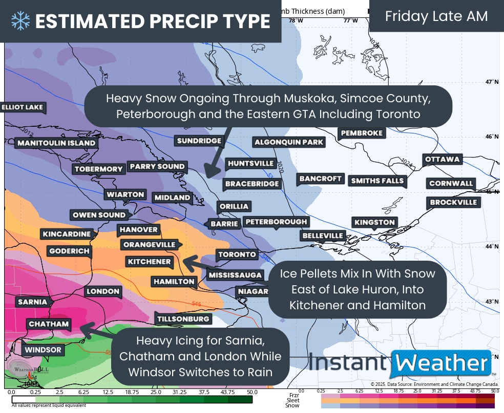
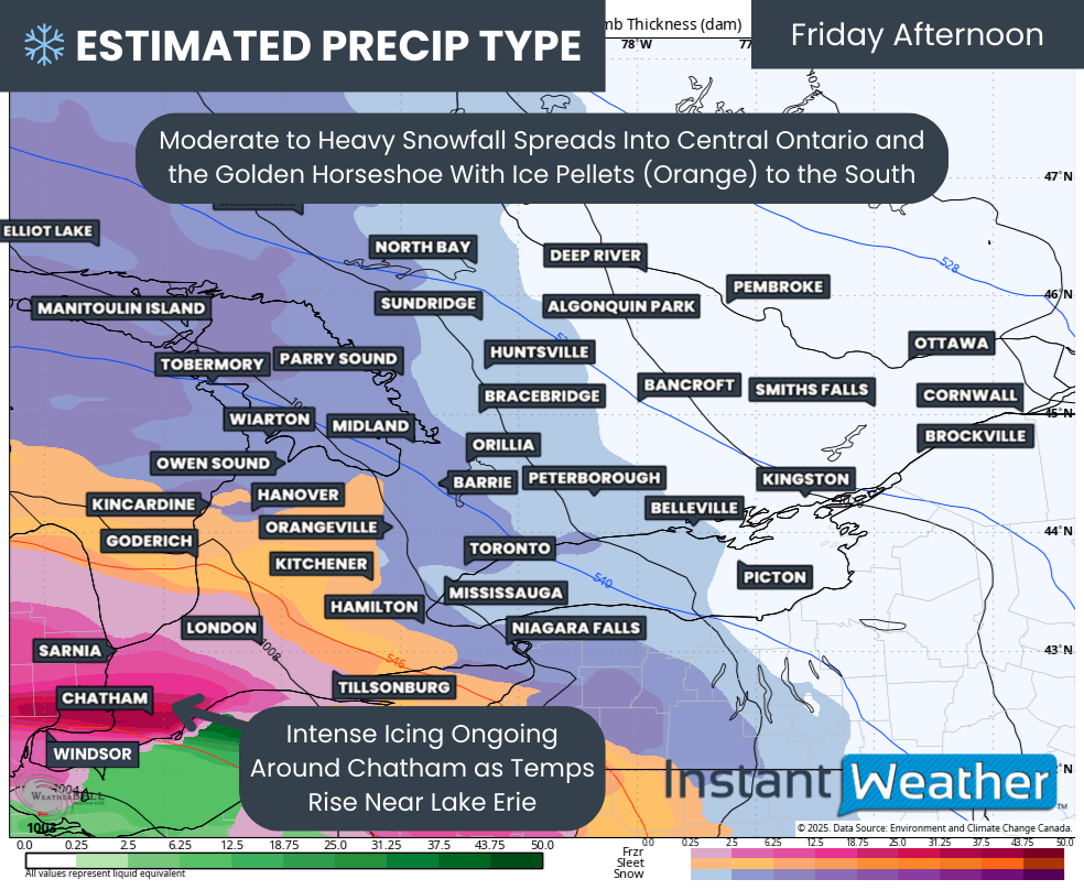
By late morning, the worst conditions should be underway, with heavy icing ongoing around Chatham, Sarnia and London. Travel conditions in these areas are expected to deteriorate quickly.

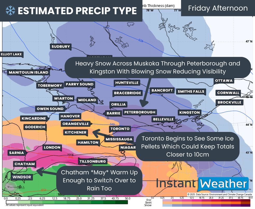
Further north and east, heavy snow will be the main concern across Muskoka, Simcoe County, Peterborough and the eastern GTA, including the City of Toronto.

Between the freezing rain to the southwest and the heavy snow to the north and east, a corridor of ice pellets is expected to develop from the Lake Huron shoreline through Kitchener and into Hamilton.

PRECIP TYPE - MAP FROM WEATHERBELL

Poor conditions will persist into Friday afternoon, with steady snowfall continuing across Central Ontario into Kingston. Wind gusts approaching 40 km/h may lead to localized blowing snow, further reducing visibility at times.

The ice pellet zone may also push further into the GTA, with Toronto potentially switching over to ice pellets for a time. This would limit snowfall totals and keep them closer to the 10 cm range.

Sarnia and London are expected to remain locked into freezing rain through much of the afternoon. There may be some hope for the Chatham area, where temperatures could briefly rise just above freezing and allow a changeover to rain by mid-afternoon. However, this is right on the line and could still go either way. Windsor and Leamington are expected to remain solidly in the rain zone.

PRECIP TYPE - MAP FROM WEATHERBELL

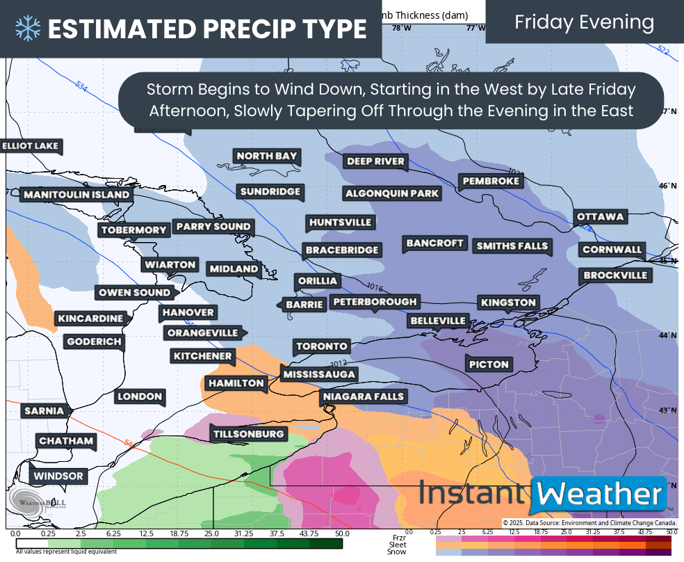
The system is expected to gradually wind down later Friday afternoon and into the early evening. Precipitation will taper off first across western areas, then slowly come to an end across the Golden Horseshoe and Eastern Ontario by late evening.

NOTE: YOU CAN CLICK ON THE MAP TO OPEN A ZOOMABLE IMAGE

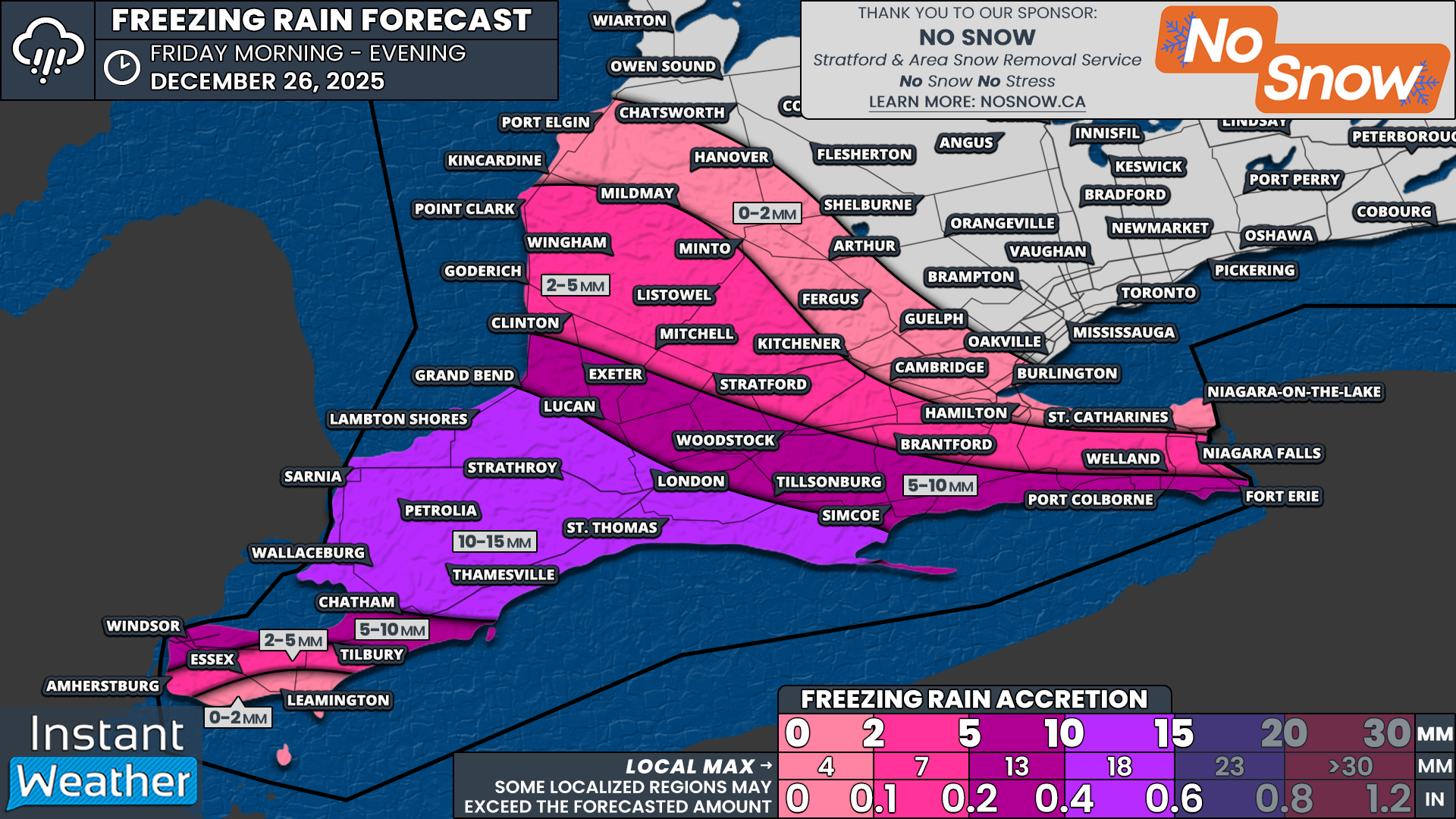
Based on the latest data, the highest ice storm concern has been focused on the Sarnia, Lambton, Middlesex and London corridor. While there is still some disagreement on exact intensity, the potential exists for ice accretion exceeding 10 mm, with localized amounts approaching 15 mm.

Communities included in this higher risk zone include Wallaceburg, Sarnia, Petrolia, Thamesville, Lambton Shores, Grand Bend, St. Thomas and London.

Across Essex County, the highest ice accretion is expected in the northern portions of the county, including Windsor and Tilbury. These areas could see 5 to 10 mm of ice before a changeover to rain. Closer to the Lake Erie shoreline, including Leamington, icing should be minimal, generally under 2 mm, as temperatures rise above freezing more quickly.

Further north, freezing rain amounts will be reduced as ice pellets dominate initially, with freezing rain gradually mixing in later. Locations such as Lucan, Exeter, Woodstock, Tillsonburg, Simcoe, Port Colborne and Fort Erie could see a faster transition to freezing rain, with 5 to 10 mm of ice possible following a few hours of ice pellets.

For Huron and Perth counties, including Kitchener, Brantford and Niagara Falls, ice pellets are expected to linger longer. This will limit freezing rain to only a few hours near the end of the storm, with ice accretion generally in the 2 to 5 mm range. Less than 2 mm of icing is expected for Hamilton, Guelph and southern Grey-Bruce.

NOTE: YOU CAN CLICK ON THE MAP TO OPEN A ZOOMABLE IMAGE

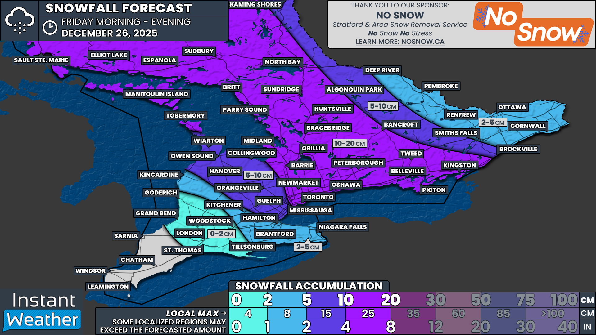
On the snowfall side of the storm, the highest totals are expected to range from 10 to 20 cm across Northeastern Ontario, down into Central Ontario and parts of Eastern Ontario.

This includes areas such as Sudbury, North Bay, Parry Sound, Muskoka, Simcoe County, York Region, Toronto, Durham Region, the Kawarthas, Peterborough and Kingston.

Lower snowfall totals are expected in the Ottawa Valley, where amounts of 2 to 5 cm are forecast for Ottawa and 5 to 10 cm from Bancroft into Brockville. This is due to the core of the system’s moisture remaining further south.

South of the heaviest snow band, totals will decrease as ice pellets mix in later in the storm. Grey-Bruce, Orangeville, Guelph and the western GTA are currently expected to see 5 to 10 cm, though some model solutions suggest even less if mixing becomes more dominant.

Even lower snowfall totals are expected east of Lake Huron into Hamilton and Niagara, where less than 5 cm is forecast as ice pellets and freezing rain become the primary precipitation types.

PRECIP TYPE - MAP FROM WEATHERBELL

Once this system exits Friday night, Saturday should bring a brief period of calmer weather. However, that break will be short-lived, as another potentially high-impact winter storm is expected to approach as early as Sunday, possibly arriving in multiple waves.

The overall setup supports the potential for a prolonged area of freezing rain that could remain locked in place into Monday. This raises concern for a significant ice storm event, potentially similar in nature to last winter’s devastating storm across Central and Eastern Ontario.

Those same regions are once again in the early bullseye. While there is still time for this forecast to change, this is the type of setup where residents should begin thinking ahead and preparing for the possibility of extended power outages if the scenario does not improve.

We will continue to monitor this closely and will have a more detailed update once we get through Friday’s storm.

Potential Boxing Day Winter Storm Targets Southern Ontario With Significant Freezing Rain Risk and Up to 15-20cm of Snow

NOTE: YOU CAN CLICK ON THE MAP TO OPEN A ZOOMABLE IMAGE

While winter weather has mostly taken a breather across Southern Ontario over the past week, things are about to turn active again as we head into the final days of 2025.

That change begins on Boxing Day with a messy winter system expected to slide through Southern Ontario. This system will bring a wide range of hazards, including the threat of significant freezing rain in Deep Southwestern Ontario and more widespread snowfall across much of the rest of the region.

There are still some question marks surrounding this storm, particularly when it comes to how strong it ultimately becomes. Some lower-resolution models show a fairly robust system with plenty of moisture to work with. At the same time, higher resolution guidance that is now coming into range is hinting at some drier pockets, which could cause this system to underperform in spots.

Complicating matters further is the fact that this system has the characteristics of an Alberta Clipper. Clippers are notorious for being difficult to forecast since they often lack a deep source of moisture, and small changes can make a big difference in precipitation type and totals.

What we do know at this point is that impacts will vary significantly across Southern Ontario. The highest risk area continues to be Deep Southwestern Ontario, especially the Windsor, Chatham and Sarnia region, which currently sits in the bullseye for prolonged freezing rain.

In these areas, sustained freezing rain could lead to substantial ice accretion on roads, trees and power lines. This would result in dangerous travel conditions and an increased risk of power outages. With over 10mm of icing possible, there is also concern for widespread tree damage as branches struggle under the weight of the ice.

Further north, from areas east of Lake Huron through the Greater Toronto Area and into Central and Eastern Ontario, the primary precipitation type is expected to be snow. Snow will fall steadily through much of the day on Friday with general accumulations of 5 to 15cm by the end of the day. Locally higher amounts approaching 20cm are possible west of Lake Ontario around the Toronto area due to lake enhancement.

PRECIP TYPE - MAP FROM WEATHERBELL

The first bands of precipitation are expected to arrive early to mid-morning on Friday, spreading across Lake Huron into Southwestern Ontario. As the system moves in, it will encounter a stubborn layer of cold air near the surface across Deep Southwestern Ontario, including Windsor, Leamington, Chatham and Sarnia.

At the same time, warmer air will surge in above the surface, creating a classic setup for freezing rain. This warm layer aloft melts the snow into rain, which then freezes on contact with cold surfaces at the ground.

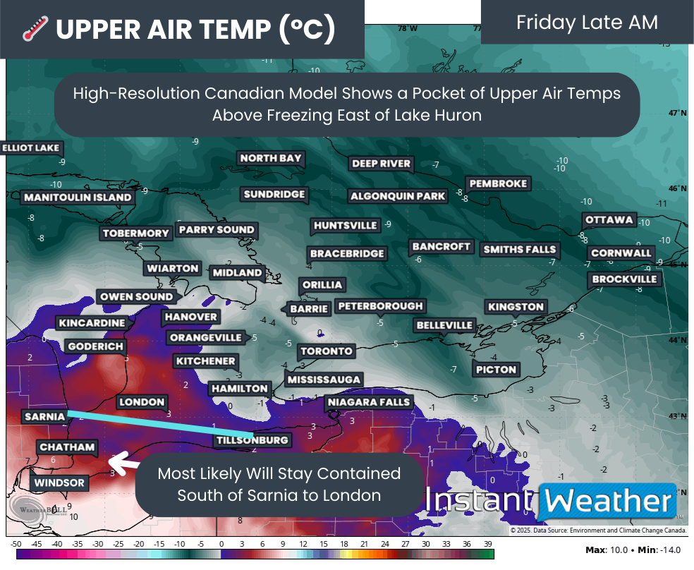
850MB TEMPS (1.5KM ABOVE GROUND) - MAP FROM WEATHERBELL

The biggest challenge with events like this is determining how far north and how deep that warm layer extends. This is the key factor that decides whether precipitation falls as ice pellets or as freezing rain.

Temperatures roughly 1.5km above the surface vary considerably between models. The Canadian model is more aggressive, pushing the warm layer farther north into Southwestern Ontario and even as far as London.

Overall, model consensus places the freezing line somewhere near a Sarnia to London corridor. Areas south of this line are more likely to see freezing rain, while areas to the north will see a mix of ice pellets and snow.

PRECIP TYPE - MAP FROM WEATHERBELL

By the early afternoon, heavier snow will begin spreading into Central Ontario and the Golden Horseshoe as precipitation from Northern Ontario moves southeast across Georgian Bay. At the same time, freezing rain will be ongoing around Windsor, Chatham and Sarnia.

There are indications that temperatures may slowly climb above freezing for southern Essex County, including Leamington and eventually Windsor. There is still disagreement on the exact timing of this changeover, but it appears most likely sometime during the early to mid-afternoon.

If temperatures do rise above freezing, freezing rain would switch to plain rain, and any ice accretion would begin to melt. How quickly this happens will be critical in determining overall impacts. If the warmup is delayed until later in the day or temperatures stubbornly remain below freezing before dropping Friday night again, impacts could be significantly worse.

For areas like Chatham-Kent, Sarnia and St. Thomas, there is growing concern that temperatures may remain below freezing for much of the event. This would allow ice to accumulate for a prolonged period, with over 10mm of accretion possible. Ice amounts of this magnitude are capable of bringing down tree limbs and power lines, potentially leading to power outages that could last for several days.

Hourly snowfall rates (cm) - MAP FROM WEATHERBELL

By mid-afternoon, the heaviest snow will be pushing through the Golden Horseshoe. Some models are showing the potential for lake enhancement along the Lake Ontario shoreline from Niagara through Hamilton and into Toronto. If this develops, snowfall rates could briefly spike to 3 to 5cm per hour compared to the more general 1 to 2cm per hour elsewhere.

It is also important to note that ice pellets may mix in at times, which can limit snowfall totals since ice pellets are denser than snow. This is most likely for areas such as London, Kitchener, Hamilton and Niagara, where conditions are more supportive of mixed precipitation. Areas closer to Toronto and farther north into Central Ontario should see more consistent snow.

Light to moderate snow will also spread into Eastern Ontario by the afternoon and continue into the evening before tapering off around midnight. Confidence in snowfall totals here is lower, but amounts in the 5 to 10cm range appear possible by the end of the day.

NOTE: YOU CAN CLICK ON THE MAP TO OPEN A ZOOMABLE IMAGE

While there is decent agreement on the overall track of this system, fluctuations are still very likely. Freezing rain events are among the most difficult to forecast, and even small temperature changes can have major impacts.

At this time, the highest confidence for the worst impacts remains across the Chatham, Windsor and St. Thomas area, where a persistent band of freezing rain is expected to set up for much of the day on Friday. Some models show up to 20mm of liquid precipitation, though not all of that would freeze on surfaces. For now, we are forecasting over 10mm of ice accretion, with the understanding that an overachieving scenario is still on the table.

For southern Essex County, including Leamington and possibly southern Windsor, ice accretion of 5 to 10mm is possible before a changeover to rain. Because of this transition, overall impacts should be lower compared to areas farther north, where freezing rain may last longer.

Farther north, from Sarnia through London and into Norfolk County, precipitation may begin as ice pellets in the morning before transitioning to freezing rain later in the afternoon or early evening. Ice accretion here could range from 3 to 8mm, depending on how quickly this transition occurs.

A corridor stretching from Goderich through Kitchener, Hamilton and into the Niagara region is expected to start with heavier snow Friday afternoon. Mixing with ice pellets later in the day could reduce snowfall totals, with most areas seeing around 5 to 10cm by the end of the event.

Areas that remain predominantly snow from start to finish include Grey-Bruce, much of Central Ontario, Eastern Ontario and the eastern portions of the GTA. Snowfall totals here should generally range from 10 to 15cm, with localized amounts up to 20cm. In Eastern Ontario, especially closer to the Quebec border, totals may struggle to reach 10cm, making 5 to 10cm a more realistic expectation.

We will continue to monitor the latest data closely and will have a more detailed and refined forecast on Thursday night. That update will provide a clearer breakdown of precipitation types and expected amounts. Be sure to check back for the final forecast.

Blizzard Conditions Expected as High Impact Winter Storm Targets the Prairies Wednesday With Up to 30cm of Snow

NOTE: if you click or tap on this image you can zoom in

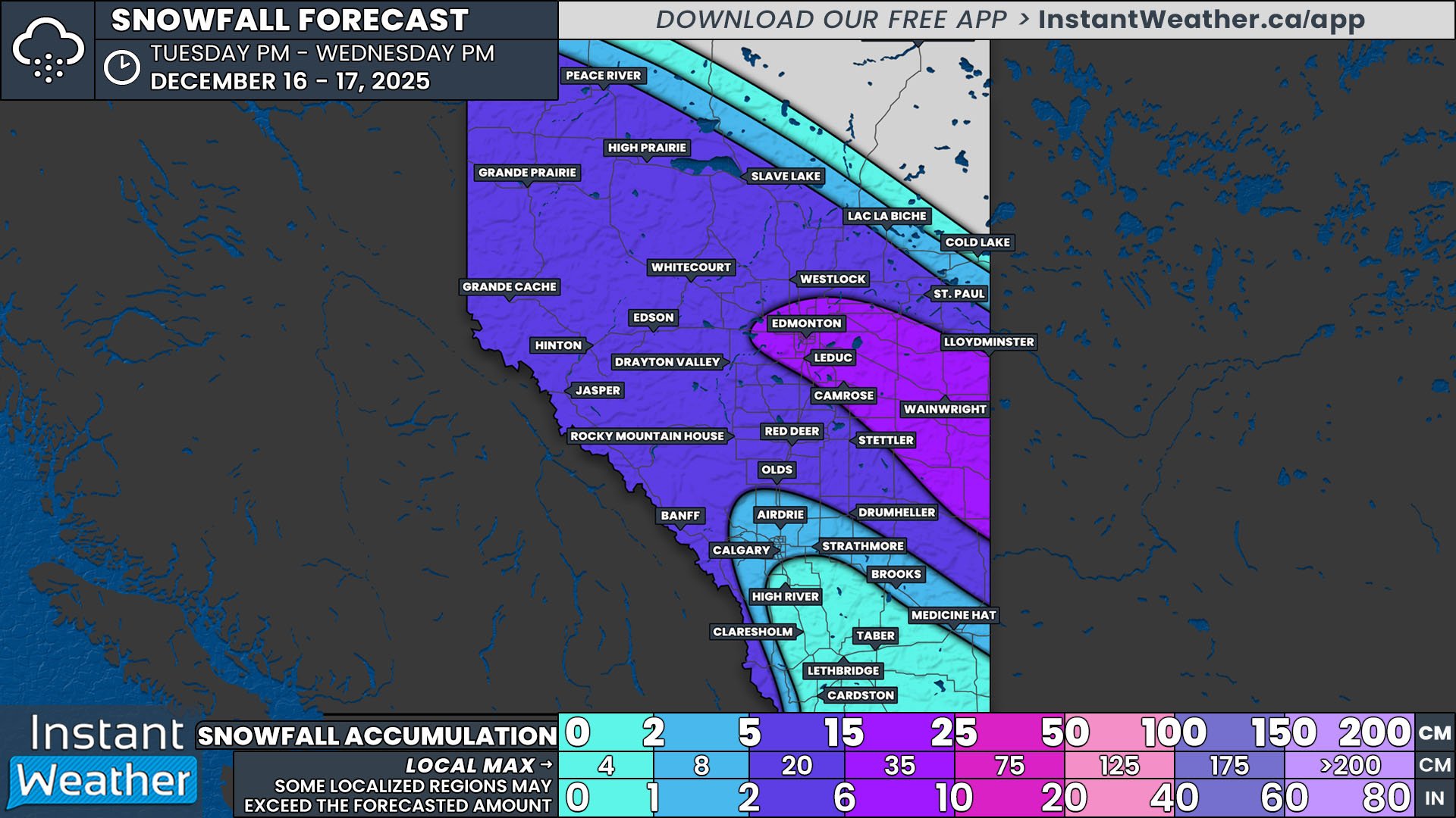
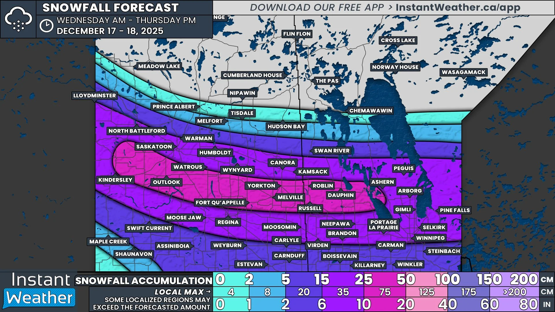
The next Clipper to cross the Prairies, the latest in the seemingly never-ending train of such systems, is setting up to be the most impactful of the season so far. This system will bring 15+cm of snow to all three provincial capitals, along with blizzard conditions to parts of Southern Saskatchewan and Manitoba Wednesday and into Thursday. There has been little change in the projected track of the Clipper since we shared our preliminary forecast Monday evening so many of the details remain the same and total snowfall accumulations have become clearer.

Alberta

Snow has fallen throughout the day Tuesday in the Rockies and this will continue into the evening and overnight. Late Tuesday evening, the snow will begin to expand southeastward from Northwestern Alberta as the low pressure center associated with the system starts to make its way into the province. The leading edge of the snow will cross Alberta through the early morning hours, reaching the Saskatchewan border shortly before sunrise.

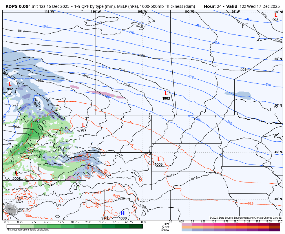
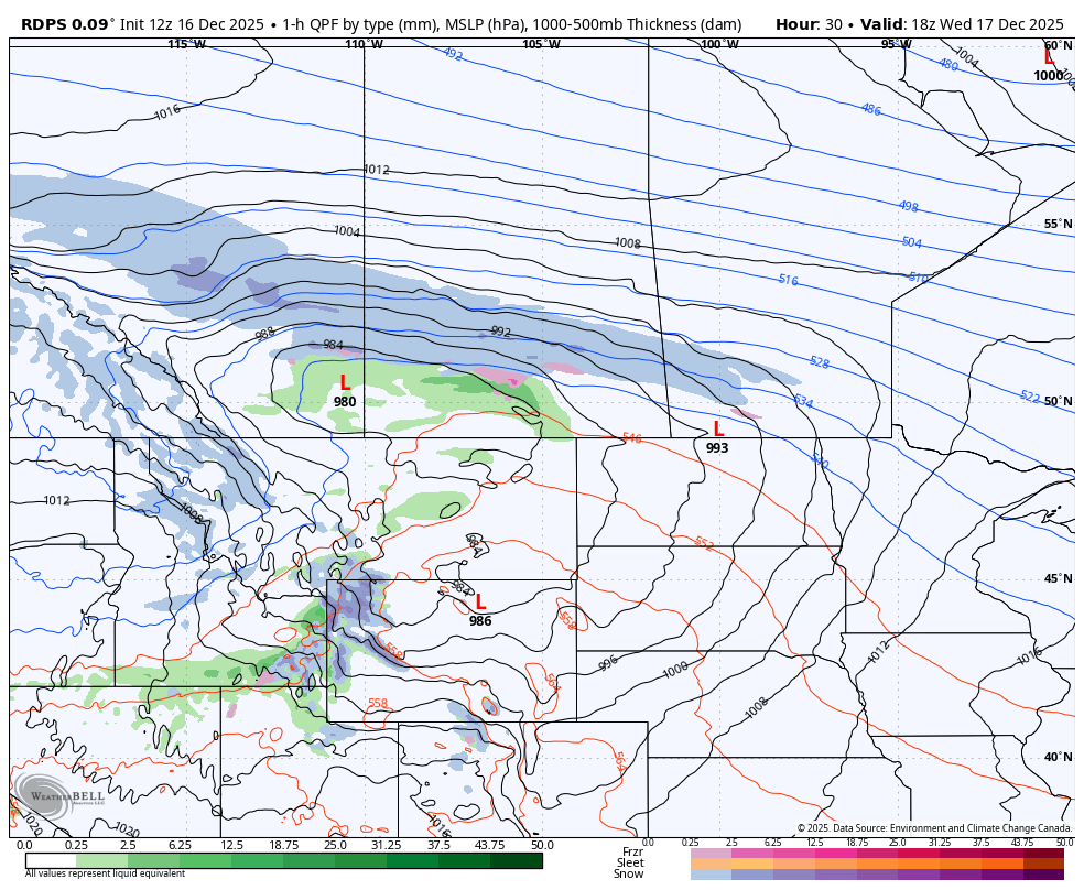
The rdps model showing precipitation type and intensity at 5Am MT on Wednesday, courtesy of WeatherBell.

The snow will be fairly light to moderate for most of the impacted areas of Alberta. A majority of Southern Alberta can expect less than 5cm since the precipitation will start off as a mixture of rain and freezing rain, possibly for several hours, due to the temperatures hovering around the freezing mark. However, there will be a switch over to snow as the temperatures drop, leading to the freezing of wet surfaces and minimal snow accumulation.

To the north, the lack of warm air and more consistent snowfall will result in greater accumulations. A large swath of Central Alberta and into Northern Alberta can expect 5-15cm of fresh snow, falling at rates of 1-2cm/hr during the late morning and early afternoon. In the Edmonton area and southeastward through Wainwright to the Saskatchewan border, heavier snow is expected to fall, possibly exceeding 3cm/hr, leading to rapid accumulation above 15cm.

In the early afternoon, the snow will begin to taper off from northwest to southeast across Alberta and it will gradually exit the province during the evening.

NOTE: if you click or tap on this image you can zoom in

The rdps model showing precipitation type and intensity at 12Pm CST on Wednesday, courtesy of WeatherBell.

Saskatchewan

As the system makes its way through Saskatchewan, the situation becomes quite a bit messier. The leading edge of the precipitation will start to push through the province during the morning mostly as snow, but with rain, freezing rain, and ice pellets in the mix through the warmer air that will be present in Southern Saskatchewan. The freezing rain could last for several hours, resulting in a few millimetres of ice buildup on untreated surfaces. However, as the low tracks eastward during the afternoon, cold air will wrap around and result in a freezing of wet surfaces and a period of snow that follows.

Meanwhile, across Central Saskatchewan, as the snow moves through the province, it will intensify. Heavy snowfall rates up to 4cm/h during the afternoon and evening will result in the widespread quick accumulation of 15-30cm over an area that includes both Saskatoon and Regina.

The rdps model showing precipitation type and intensity at 7Pm CT on Wednesday, courtesy of WeatherBell.

Manitoba

The snow will finally start to cross into Manitoba in the late morning. There will be a much smaller pocket of warm air that will be isolated to the southwest corner of the province, so while there will be a chance for a brief period of freezing rain in Manitoba, the risk won’t be as prolonged or as widespread as in Saskatchewan.

The area of heavier snowfall will spread from Central Saskatchewan into Central Manitoba through the afternoon and evening, where it will also result in a widespread 15-30cm of fresh snow, including in Winnipeg.

During the evening, the system will begin to shift and start to track more southward as it also loses some intensity. This will bring the main band of snow into Southeastern Saskatchewan and Southern Manitoba overnight and through Thursday morning.

In Saskatchewan, the snow will taper off starting shortly after midnight and exit the province by around sunrise. The snow will continue for a few extra hours in Manitoba, starting to dissipate during the early morning hours and eventually finishing in the southeast corner of the province in the afternoon.

NOTE: if you click or tap on this image you can zoom in

This only covers the snowfall aspect of this storm, but there is one major factor left to consider: the wind. Strong winds are expected to develop Wednesday morning and continue through the afternoon and evening before dying down overnight across the Prairies. We’re looking at widespread wind gusts over 60km/h and likely exceeding 100km/h, particularly in Southern Alberta and Saskatchewan. There is even the possibility of damaging wind gusts that approach 130km/h in parts of Southern Alberta!

While the most intense gusts will not coincide with the area where the heaviest snow is expected to fall, gusts above 60km/h will be more than enough for blizzard conditions to develop across Central Saskatchewan and into Central Manitoba starting in the afternoon and lasting into the overnight hours. This will likely result in large stretches of multiple highways being closed due to very poor visibility along with rapid accumulation of snow on the road surfaces.

For the rest of the region, where the wind gusts could be stronger, even a little bit of snowfall could severely impact visibility throughout the day.

Travelling in these conditions can extremely dangerous so please plan ahead, try to limit any travel, and stay safe!

NOTE: if you click or tap on this image you can zoom in

First Look at the Major Snowstorm Set to Impact the Prairies This Week

NOTE: if you click or tap on this image you can zoom it

After a seemingly constant stretch of back-to-back clippers bringing brief blasts of snow, we’re finally looking at a proper snowstorm across the Prairies this week. While this will be another clipper, it will be much more impactful, bringing periods of heavy snow to Edmonton, Saskatoon, Regina, and Winnipeg. Here’s a preliminary look at roughly what can be expected, but keep in mind that exact timing and snowfall amounts will likely change between now and the start of the event.

The snow is set to begin late Tuesday or very early Wednesday morning in the Rockies and Northern Alberta before gradually spreading eastward with the trajectory of the associated low. The leading edge of the snow will cross into Saskatchewan before sunrise Wednesday and then into Manitoba by the late morning or early afternoon.

NOTE: if you click or tap on this image you can zoom it

The snowfall should be fairly moderate as it tracks across Alberta before it starts to taper off in the evening. To the east, on the other hand, the snow is expected to intensify Wednesday afternoon in Saskatchewan and in the evening in Manitoba, leading to a significant swath of up to 30cm of heavy snowfall by the noon hour on Thursday.

To complicate matters further, strong winds with gusts exceeding 100km/h are expected across the Southern Prairies beginning Wednesday afternoon and continuing overnight. This will very likely lead to white-out conditions, possibly even reaching the threshold to be considered a blizzard, in Southern Saskatchewan and Manitoba that will probably result in highway closures.

It’s also worth noting that in the warm sector, along the southern edge of the snow, there will be the possibility of a mixture of rain, freezing rain, and ice pellets which would be followed by snow as the temperatures fall. We will have more information on this risk, along with further details regarding the entire storm in our full forecast that will be posted Tuesday evening.

NOTE: if you click or tap on this image you can zoom it

Barrie Area to Be Buried in Up to 40 to 75 cm of Snow on Thursday as Arctic Air Fuels Dangerous Snow Squalls

NOTE: YOU CAN CLICK ON THE MAP TO OPEN A ZOOMABLE IMAGE

Snowfall from the Alberta Clipper that slid through Southern Ontario earlier on Wednesday is beginning to taper off. The system has left its mark across the region with a widespread 10 to 20cm of snow in some areas, while others saw a slushy mix.

While the clipper may be done, the snowfall story is not. As the system pulls away, it ushers in a polar blast of cold air overnight on Wednesday. This air, combined with strong northwesterly winds, will kick the lake effect snow machine back into gear off Lake Huron and Georgian Bay.

Intense snow squalls across Simcoe, Huron and Perth counties throughout Thursday are likely to create dangerous conditions. Frigid wind chills paired with near-zero visibility will make travel extremely difficult and even life-threatening if you become stranded.

The Georgian Bay squall is expected to be particularly intense. A narrow corridor from Wasaga Beach through southwest Barrie, including Angus, Innisfil and into Bradford, may see the band lock in place for more than six hours. Snowfall rates could exceed 5cm per hour.

Localized totals around the Barrie area could approach 50 to 75cm in the hardest hit pocket. Some high resolution models even suggest 100cm is not completely off the table.

East of Lake Huron, activity will be persistent from Thursday morning through the evening. The lake effect here appears more spread out rather than focused on one specific pocket. The heaviest totals are expected across Huron and Perth counties, where up to 50cm is locally possible.

PRECIP TYPE - MAP FROM WEATHERBELL

As of Wednesday evening, we are already seeing some activity begin ramping up off the southeast shoreline of Lake Huron and Georgian Bay. This will continue to organize after midnight into the early hours of Thursday.

By early morning, we expect the most focused squalls to target the Goderich to London corridor off Lake Huron and the Collingwood to Bradford stretch off Georgian Bay.

Keep in mind, this is a rough idea from the models, and the exact placement can shift if the wind direction changes even slightly.

Hourly snowfall rates (cm) - MAP FROM WEATHERBELL

By the time the morning commute begins around 6 AM, snow squall activity will intensify as the Georgian Bay band becomes extremely narrow and focused. Some model runs have it stretching from Wasaga Beach through Angus and into the Innisfil to the Newmarket area.

There remains uncertainty in how much snow the City of Barrie itself will receive. The gradient between limited snow and a huge dumping will be very tight. The south and west ends are most likely to see major impacts, although it would not take much of a shift for the band to slide directly into the city.

The Lake Huron activity will begin to spread out with moderate snowfall covering much of Huron and Perth counties, including Goderich, Wingham, Stratford and Listowel. Because the band is more diffuse, there will not be one intense pocket as we expect with the Georgian Bay squall.

ESTIMATED WIND CHILL - MAP FROM WEATHERBELL

A major factor with this round of squalls that makes the situation more dangerous is the very cold wind chills. When you wake up Thursday, wind chills will make it feel like the -20s. Combined with squalls at the same time, the risk to anyone stranded on the roads increases significantly.

Aside from the cold creating hazards, it will also boost snowfall rates. Colder air produces drier, fluffier snow, which allows the same amount of moisture to create a larger volume of accumulation.

Hourly snowfall rates (cm) - MAP FROM WEATHERBELL

Little will change heading into the late morning as the Georgian Bay squall remains locked in place near the Barrie area. The band could edge far enough north to put the city core into the bullseye. Keswick may also be brought into the heavy snow as the band wobbles.

For the Lake Huron squall, the band may briefly become more focused as a single strong line cutting through Goderich and into Stratford and Woodstock. Depending on slight track shifts, Kitchener or Hamilton could also be affected at times.

Hourly snowfall rates (cm) - MAP FROM WEATHERBELL

Conditions are expected to deteriorate further into the afternoon. The Georgian Bay squall appears to strengthen with hourly snowfall rates easily exceeding 5cm and possibly pushing 10cm. At this point, the most intense pocket is shown just southwest of Barrie, with Angus being hit hardest.

The Lake Huron squall will also become more organized with an impressive fetch stretching all the way toward Lake Erie and impacting Woodstock and Norfolk.

Hourly snowfall rates (cm) - MAP FROM WEATHERBELL

There is significant concern for the Hwy 400 corridor during the afternoon and evening commute from just south of Barrie to roughly Aurora. This section of highway will likely become snow covered with road crews struggling to keep up with extreme snowfall rates. Combined with whiteout conditions, travel in this zone should be avoided unless absolutely necessary.

Hourly snowfall rates (cm) - MAP FROM WEATHERBELL

As we head into the evening and just past midnight, the squalls will retreat closer to the lakeshores as winds weaken and moisture supply cuts off. This will lead to activity tapering to lake effect flurries overnight into Friday morning.

NOTE: YOU CAN CLICK ON THE MAP TO OPEN A ZOOMABLE IMAGE

As always with snow squalls, snowfall forecasts should be taken with a large grain of salt. While models are in good agreement on placement and intensity, nothing is guaranteed as conditions need to align perfectly.

With that being said, we believe the hardest hit zone will be along the southeastern Georgian Bay shoreline from Wasaga Beach through Angus and into northern York Region. Barrie sits right on the edge but could easily end up inside the bullseye. Snowfall totals here are likely to exceed 40cm and may approach 75cm. Around Angus is where models show the strongest signal.

A tight gradient will set up with the north and east sides of Barrie, along with Keswick, Bradford and Collingwood, likely seeing 25 to 40cm of snow.

East of Lake Huron including Kincardine, Minto, Point Clark, Wingham, Listowel, Mitchell, Stratford, Exeter and Goderich, totals of 25 to 40cm are expected. Localized amounts up to 55cm are possible if a squall locks in place for several hours.

Totals of 15 to 25cm are possible for Midland and into central York Region including Newmarket and Aurora as well as Durham Region around Uxbridge. These areas will see occasional bursts of heavy snow near the edge of the main bands.

Southern Bruce and Grey counties along with Wellington County including Arthur and Oxford County may also see 15 to 25cm but totals depend on how far inland the bands extend.

Between 5 and 15cm is possible across the rest of York and Durham Region as well as northern Simcoe County including Orillia, Owen Sound, Shelburne, Fergus, Kitchener, Brantford and London. These locations sit farther from the core activity so most will see closer to 5cm with higher amounts only if a band stretches farther inland.

Less than 5cm is expected outside the snowbelt regions including Eastern Ontario, Deep Southwestern Ontario and the Golden Horseshoe.

Back-to-Back Clippers To Deliver Up to 20cm of Snow Across Southern Ontario by Wednesday

NOTE: YOU CAN CLICK ON THE MAP TO OPEN A ZOOMABLE IMAGE

It has certainly been feeling a lot like winter over the last few weeks across Southern Ontario as the snow continues to pile up. Several clippers and rounds of lake effect snow have already delivered a healthy start to the season.

That trend shows no signs of slowing down as we enter the second week of December.

An Alberta clipper duo is set to slide through Southern Ontario back-to-back over the coming days. The second clipper arriving on Wednesday is expected to be the stronger of the two. Current indications suggest heavy snow combined with strong wind gusts may heavily impact the Wednesday morning commute.

By the time the second clipper wraps up late Wednesday, combined snowfall totals are expected to range from 10 to 20cm across a wide swath of Central, Eastern and Southwestern Ontario. Localized totals up to 25cm cannot be ruled out, especially if there is some lake enhancement.

Lower totals are expected along the Lake Ontario and Lake Erie shorelines where temperatures may climb just enough for some rain to mix in later Wednesday morning. Around 4 to 8cm is possible for Deep Southwestern Ontario and the Golden Horseshoe.

In the wake of the clippers, we are also monitoring a potential prolonged snow squall risk beginning Wednesday evening and potentially continuing through the rest of the week and into the weekend. Snowbelt regions around Lake Huron and Georgian Bay could be dealing with significant snowfall totals. There is still uncertainty regarding the exact placement of these bands.

PRECIP TYPE - MAP FROM WEATHERBELL

Things will begin to kick off late Tuesday morning into early Tuesday afternoon as precipitation from our first clipper enters from the west. Widespread light to moderate snow will spread across Southwestern Ontario, the Lake Huron shoreline and into portions of Central Ontario and the GTA.

This snow is not expected to be particularly intense, although locally heavier pockets are possible through the Bruce Peninsula and into Sudbury where lake enhancement may add extra moisture to an otherwise dry system.

Hourly snowfall rates (cm) - MAP FROM WEATHERBELL

Steady snow will continue throughout the afternoon on Tuesday and into the evening. The story with this first clipper will be the steadiness of the snowfall rather than the intensity. Major routes should remain drivable, but expect a slower evening commute with light snow ongoing at the time.

TOTAL SNOWFALL (CM) FROM CLIPPER #1 - MAP FROM WEATHERBELL

This clipper will begin to wind down later in the day on Tuesday with final amounts ranging from 2 to 8cm. The heaviest pockets will be east of Lake Huron and Georgian Bay. For the rest of Southern Ontario, accumulation will fall on the lower end of that range.

PRECIP TYPE - MAP FROM WEATHERBELL

However, do not let the lower totals by Tuesday evening lead you to let your guard down. Our next clipper is not far behind and will track toward Southern Ontario from the Midwest by late Tuesday evening.

Ahead of it, we may see a few hours of heavy snow squalls develop northeast of Georgian Bay and Lake Ontario. This could bring brief but heavy snow to areas like Parry Sound, Muskoka and Kingston.

PRECIP TYPE - MAP FROM WEATHERBELL

Conditions will really begin to deteriorate with the second clipper as the bulk of the precipitation spreads into Southwestern Ontario and the Golden Horseshoe right at the height of the Wednesday morning commute.

Some wet snow or even rain may mix in along the Lake Ontario and Erie shorelines which could suppress totals around the GTA and Niagara region.

Hourly snowfall rates (cm) - MAP FROM WEATHERBELL

The key difference with this clipper compared to the one 24 hours earlier is that the snowfall will arrive in a much shorter window instead of being spread throughout the day.

Hourly snowfall rates may reach 2 to 4cm through the London to Kitchener corridor. While the intense snow will not last long, just a few hours of that kind of snowfall can add up fast.

Winds are also expected to gust up to 60 km/h which combined with heavy snowfall could produce blowing snow and significantly reduced visibility. The morning commute is likely to be heavily impacted and school bus cancellations are quite possible on Wednesday.

Hourly snowfall rates (cm) - MAP FROM WEATHERBELL

The heaviest snowfall rates will not last long for Southwestern Ontario and the GTA as the 1+cm per hour rates shift into Central and Eastern Ontario by late morning.

Temperatures will also rise through the late morning and early afternoon which may allow some rain to mix in around the GTA and the Lake Erie shoreline.

PRECIP TYPE - MAP FROM WEATHERBELL

And yet, that is only the beginning because as the second clipper exits the region late Wednesday, the lake effect snow machine is expected to fire back up quickly by Wednesday evening.

Current data shows a focus on the London, Huron, Grey-Bruce, Collingwood and Barrie areas Wednesday night. The lake effect risk may carry into Thursday and possibly into the weekend as very cold air settles across Southern Ontario.

It remains unclear whether the wind direction will become stable enough to allow long-lasting snow squalls, but if it does, we could be looking at staggering snowfall totals by next week.

We will have a more precise breakdown of the snow squall risk closer to Thursday once high resolution model data is available to pinpoint where the bands may focus.

NOTE: YOU CAN CLICK ON THE MAP TO OPEN A ZOOMABLE IMAGE

Turning back to the combined snowfall totals from the two clippers, we expect a wide zone stretching across much of Central and Eastern Ontario and into Southwestern Ontario east of Lake Huron to end up around 10 to 20cm. There is potential for over-performance as some recent models have trended upward showing widespread 20 to 25cm. As clippers can sometimes struggle with moisture, we have undercut that slightly to better reflect the consensus.

One area where that moisture struggle may occur is southeast of Georgian Bay, including Barrie and York Region. Models show slightly lower totals of 6 to 8cm here, so we have placed those regions in a 5 to 10cm range. This 5 to 10cm zone also extends along the Hwy 401 corridor into Deep Southwestern Ontario and into the Ottawa region.

For regions directly along the Lake Ontario and Erie shorelines like Toronto, Mississauga, Oakville, Burlington, Hamilton and St Catharines, snowfall may struggle to reach 5cm due to mixing potential and above freezing temperatures limiting accumulation.

Keep in mind that these are combined snowfall totals from both systems. Roughly 50-75 percent of the total will likely fall within a 6 hour period on Wednesday which is when conditions will be at their worst.

Additional snowfall is possible later Wednesday into Thursday with snow squall activity. Those amounts are not included in this map. A separate forecast will be issued on Wednesday for that.

Nasty Winter Storm Will Bring Mixed Bag of Precipitation, Flash Freeze Risk, and Strong Winds to Alberta Monday & Tuesday

NOTE: if you click or tap on this image you can zoom it

The forecast across Alberta for Monday and Tuesday is certainly complex. We are looking at all precipitation types; rain, snow, freezing rain and ice pellets; to be falling somewhere in the province and some places could see a combination of different kinds of precipitation. There is also a widespread risk of a flash freeze and to top it all off, wind gusts exceeding 100km/h are likely.

Before we get too ahead of ourselves, let’s start with the least complicated aspect of the forecast: the snow in Northern Alberta and through the Rockies.

Northern Alberta & The Rockies

Light snow has been falling in parts of Northern Alberta Monday morning and into the afternoon, trailing the previous round of widespread snowfall across the region. A narrow band of snow will persist through the afternoon and drop 5+cm of accumulating snow by the evening.

The Hrdps model showing precipitation type and intensity at 5Pm MT on Monday, courtesy of WeatherBell.

In the evening, widespread snow will move into Northern Alberta, including the Northern Rockies, from British Columbia. The snow will spread southeastward across Northern Alberta and into parts of Central Alberta during the evening and overnight hours.

The snowfall will last for up to 8 hours and it will start to taper off along the BC border shortly after midnight. This large band of snow will exit into Saskatchewan before sunrise, but scattered areas of light snow will linger through the morning across Northern Alberta.

The area that is expected to see snow throughout Monday afternoon will end up with the greatest accumulation by Tuesday afternoon. More than 15cm of fresh snow is anticipated over this area, especially in Peace River, on top of what has already fallen from the weekend. Beyond this, the rest of Northern Alberta and into parts of Central Alberta will be in the 5-15cm range and accumulations decrease moving southward. There is a slight caveat to this, which we will touch upon a bit further down.

NOTE: if you click or tap on this image you can zoom it

For the Rockies, the snowfall will spread southward during the evening and overnight. Overall, 5-15cm can be expected throughout this region. The higher elevations will approach 15cm while the valleys will be closer, or possibly even below, 5cm.

Central Alberta

Things start to get messy in parts of Central Alberta as the band of snow travels southeastward into the region.

The arrival of a warm front that crossed through Central and Southern Alberta overnight Sunday has resulted in temperatures climbing to a few degrees above the freezing mark across the region. As the snow from Northern Alberta tracks southeast through the evening and overnight Monday, and encounters this warmer air above the surface, there will be a transition over to ice pellets (sleet) and freezing rain.

This is expected to start to occur to the north of Edmonton, from Whitecourt to St. Paul. Despite the surface temperatures remaining subzero in this area, there will be enough warm air aloft for the transition to ice pellets to happen and this area could see a few centimetres of ice pellets accumulating. The caveat mentioned above is that the map of snowfall totals also includes accumulation of ice pellets in this area.

precipitation types and their corresponding temperature profiles

Moving southward, the amount of warm air aloft increases and the precipitation will change to freezing rain. The area at risk of freezing rain stretches roughly from west of Drayton Valley and Rocky Mountain House to Wainwright and Provost. The northern part of this area will likely see a combination of ice pellets and freezing rain as the thickness of the warm air aloft decreases.

The freezing rain is expected to be light and only last for an hour or two, resulting in up to 1mm of ice accretion. However, this is still enough to cause some issues when travelling on untreated roads.

Timing-wise, the ice pellets and freezing rain will start to fall as early as 7pm Monday evening and continue into the overnight hours as the band of precipitation tracks towards Saskatchewan.

The rdps model showing precipitation type and intensity at 3am MT on Tuesday, courtesy of WeatherBell.

Southern Alberta

In Southern Alberta, as well as in portions of Central Alberta, surface temperatures hovering around zero, and slightly above, will lead to precipitation falling as rain with a bit of wet snow mixed in. The rain will be light and scattered, broken off from the main band of precipitation, throughout the region overnight and into Tuesday morning. Unfortunately, this poses a unique problem for this region.

In the early morning hours of Tuesday, a sharp cold front will start to blast southward through Central and Southern Alberta. Temperatures could plunge by up to 20°C in the span of only a few hours, resulting in a flash freeze of any rain that has fallen, as well as the snow melt from the previous day.

This flash freeze is expected to happen just in time for the morning commute for Calgary and communities to the north, so road conditions could be very poor if they aren’t treated ahead of time and maintained. The cold front will then stall around Calgary through the morning and afternoon before it continues tracking southward during the evening, bringing below freezing temperatures to the rest of Southern Alberta.

If that wasn’t enough, strong winds gusts up to, and possibly exceeding, 100km/h are possible in Southwestern Alberta overnight Monday. Luckily, these strong winds should die down by Tuesday morning.

The hrdps model showing surface temperature at 1am MT on Tuesday, courtesy of WeatherBell.

The hrdps model showing surface temperature at 0am MT on Tuesday, courtesy of WeatherBell.

All in all, this incoming system will impact most of Alberta, with each region expecting to be impacted in different ways. Road conditions will deteriorate across the province at some point over the next 24 hours so make sure to plan accordingly when travelling and stay safe.

Yet More Snow on the Way for Southern Ontario With a Snowy System on Sunday Bringing Up to 10-20cm

NOTE: YOU CAN CLICK ON THE MAP TO OPEN A ZOOMABLE IMAGE

As many communities in the snowbelt regions around Lake Huron and Georgian Bay are currently digging out from locally over 50cm of snow from squalls over the past two days, another snow maker is already on the way, just in time for the final days of November.

Instead of very isolated pockets seeing intense snowfall totals as we have seen with the lake effect activity, this system will spread accumulating snow across almost all of Southern Ontario. Widespread totals by the end of the weekend are expected to range from 5 to 15cm, with locally as much as 20cm in the areas that remain colder for longer.

Snowfall is expected to begin moving in from the west by late Saturday evening, starting first across Deep Southwestern Ontario. By the middle of the overnight, steady light to moderate snowfall will extend across almost all of Southern Ontario as the system further progresses into our region.

By late Sunday morning, southwesterly winds flowing across the still warm waters of Lake Erie and Lake Ontario are expected to push temperatures several degrees above freezing along the northern shorelines. This may allow the last remaining few hours of precipitation to switch over to rain for some communities right along the lakeshore.

There could also be a lake effect component to this system as it departs our region to the east. As this happens later in the day on Sunday, we may see locally heavier pockets of lake effect snow develop east of Lake Huron and Georgian Bay, which also happens to include some of the same areas hit hard by the squalls over the last few days. This could push weekend totals into the 20 to 25cm range, especially if these bands linger longer into Sunday night.

Looking ahead to the start of the week, Monday should be fairly quiet as the lake effect activity tapers off early in the morning and the remaining flurries from the system fizzle out. It will certainly be colder with everyone seeing temperatures plunge below freezing. However, that calm weather may be short-lived.

There are early indications of another potential system sliding south of the Great Lakes region. Depending on the track, this could bring another round of heavy snow throughout the early part of Tuesday, especially for areas further southeast.

Hourly snowfall rates (cm) - MAP FROM WEATHERBELL

The initial bands of snowfall associated with the weekend system will begin to enter Southwestern Ontario from the west sometime just after the dinner hour on Saturday.

For most areas, the snowfall should be fairly light at first, but some models are showing the potential for several hours of heavier snowfall rates approaching 2 to 4cm per hour for Windsor, Leamington and Chatham. This could lead to a quick 5 to 10cm by the end of the night if the heavier bursts materialize.

Hourly snowfall rates (cm) - MAP FROM WEATHERBELL

As we head into the overnight hours, the system is expected to continue spreading eastward across Southern Ontario, with almost all areas seeing steady snowfall by the middle of the overnight.

Snowfall rates are not expected to be overly extreme, with most regions seeing less than 1cm per hour through Sunday morning. Even still, this snowfall is expected to continue for 6 to 12 hours, which will allow the totals to gradually build up.

Because the snow will be more widespread and less intense than recent squall activity, road crews should be able to keep up with the conditions on most major routes. Travel delays are still likely, so if you do need to drive, be sure to leave plenty of extra time and adjust your speed based on the conditions.

TEMPERATURE - MAP FROM WEATHERBELL

Winds are expected to pick up through the later part of Sunday morning, coming out of the southwest, and flowing across Lake Erie and Lake Ontario. This will push warmer air into the northern shorelines, which may allow the snow to switch over to rain directly along the Lake Erie and Lake Ontario shorelines.

Due to this transition, slightly lower snowfall totals are expected here, and some areas may struggle to reach the 5cm mark. This includes the Greater Toronto Area near the lakeshore, along with Port Colborne, Norfolk County, Tillsonburg, St. Thomas and Rondeau.

PRECIP TYPE - MAP FROM WEATHERBELL

The system is expected to gradually taper off through Sunday afternoon, leaving scattered flurries in its wake into the evening. This leftover precipitation is likely to be enhanced by Lake Huron and Georgian Bay through Sunday evening and into the overnight hours.

Expect an additional 5 to 10cm of snowfall on top of the system totals in the areas that see lake effect enhancement. This could push the end-of-weekend totals to locally as much as 20 to 25cm in the traditional snowbelt regions.

NOTE: YOU CAN CLICK ON THE MAP TO OPEN A ZOOMABLE IMAGE

When it comes to the distribution of precipitation, we expect it to fall fairly evenly across the province. However, snowfall totals will vary based on temperature differences, which will influence how efficiently the snow can accumulate.

The higher snowfall totals from this event are expected in the more northern sections of Central Ontario and extending into the Sudbury and North Bay region. This includes Parry Sound, Muskoka, Algonquin Park and Bancroft.

These regions will see more sustained below freezing temperatures throughout the event, along with lake effect enhancement late Sunday. With this, we are looking at around 10 to 20cm, with locally up to 25cm possible in the heavier lake effect pockets.

A similar situation is expected east of Lake Huron and along the higher elevations of the Dundalk Highlands and Oak Ridges Moraine, where slightly colder temperatures will help accumulations. Expect 10 to 20cm in these areas as well, with localized totals around 25cm, especially east of Lake Huron.

Everyone else, with the exception of the Lake Erie and Lake Ontario shorelines, is looking at a general 5 to 10cm. Some areas could see locally up to 15cm if temperatures end up just a bit cooler than expected. This includes the rest of Southwestern Ontario into Windsor, Chatham and Sarnia, the Lake Simcoe region and parts of the Ottawa Valley.

For communities exposed to the shorelines of Lake Erie and Lake Ontario, which includes Toronto, Oshawa, Oakville, Hamilton, Niagara-on-the-Lake, Port Colborne and Rondeau, snowfall totals will likely be closer to the 2 to 5cm range due to the warmer air intrusion and rain mixing during the latter part of the system.

PRECIP TYPE - MAP FROM WEATHERBELL

As we look into next week, we are closely watching another potential system that could have an impact on Southern Ontario throughout the day on Tuesday. There is still some uncertainty on the exact track, with the latest model runs shifting it slightly further north, which would increase impacts across a wider portion of the region. However, it could easily shift back south.

At this point, we can say there is a decent chance of 5cm or more across a wide stretch of Southern Ontario, with the highest probability being further southeast, including the Niagara region and communities along the St. Lawrence River. Be prepared for possible impacts to the Tuesday morning commute, including the potential for school bus cancellations if the system trends stronger.

Expect possible impacts to the morning commute on Tuesday, including possible school bus cancellations, should we see a stronger system.

Winter Storm Targets Northern Ontario This Week as Intense Snow Squalls Line Up for Southern Ontario Starting Thursday

NOTE: YOU CAN CLICK ON THE MAP TO OPEN A ZOOMABLE IMAGE

A powerful system will sweep through the Great Lakes region this week, bringing a major winter storm to Northern Ontario and setting the stage for a significant snow squall event across Southern Ontario later in the week.

Across Northern Ontario, snowfall will begin to move into regions east of Lake Superior by late Tuesday. Light snow will start from Wawa through Timmins, gradually expanding north and west. Through the overnight hours into Wednesday morning, the system will push into Thunder Bay, Kapuskasing and surrounding communities.

The worst conditions are expected throughout the day on Wednesday. Winds will gust between 40 and 60 km/h, and when combined with heavy snowfall rates, visibility will deteriorate quickly. Blowing snow will be widespread across Northeastern Ontario and conditions may even reach blizzard levels at times.

Treacherous travel conditions will continue into Wednesday night and persist through Thursday morning as the storm deepens. Snowfall intensity will gradually ease later on Thursday, but steady snow will continue as the system stalls over Quebec. This will push long lasting bands of precipitation back into Northeastern Ontario, keeping snow going until early Friday morning.

By the time the storm fully exits, a wide swath of Northeastern Ontario is expected to receive 20 to 50 cm of snow, with localized totals possibly exceeding that. The heaviest totals are expected from Marathon through Kapuskasing, Cochrane, Timmins, and Temiskaming Shores, Wawa, Hearst and Chapleau. Snowfall totals here will range from 30 to 50cm with possibly as much as 60cm in localized pockets.

While Northern Ontario deals with the winter storm, Southern Ontario will be on the warm side of the system on Tuesday and Wednesday. Many areas will flirt with the double digits, especially in Southwestern Ontario. Scattered showers will develop early Tuesday with light rainfall amounts of roughly 5 to 10 mm.

By late Wednesday, though, the pattern begins to shift as cold air wraps in behind the departing system. Temperatures will drop quickly, and any lingering precipitation will change to wet snow by Wednesday evening.

This colder air will set the stage for lake effect snow to fire up. With a westerly wind overnight on Wednesday, snow squalls may begin to develop off Lake Huron and Georgian Bay.

These early bands could bring bursts of heavy snow to Grey Bruce, Parry Sound and Muskoka through Thursday afternoon, although the exact intensity remains uncertain as the higher resolution models are just entering range and showing stronger signals than the medium range guidance.

By late Thursday, winds will shift to a northwest flow. Temperatures will drop further into the negatives and this will allow squalls to strengthen. The Georgian Bay band is expected to sink south into Simcoe County and then extend into Kawartha Lakes and Peterborough.

At the same time, the Lake Huron band will slide south into Huron County and stretch toward Kitchener and the western GTA. Some early guidance even hints that this band could link up with the flow off Lake Superior, which can enhance snowfall rates.

Heading into Friday, it is still too early to give precise band placement. Current thinking suggests the northwest flow will hold through much of the day before winds start easing over the weekend. If that happens, squalls could remain active for an extended period.

While details can still shift, we are beginning to narrow down regions with the highest risk of heavy snowfall starting Thursday morning and continuing into Friday evening. Squalls will shift around at times, so snowfall will not be constant, but those under the core of the bands could see snowfall rates approaching 5 to 10 cm per hour. It will not take long for the snow to accumulate.

At this stage, exact totals are not possible to predict for Southern Ontario. However, some regions could easily see 25 to 50 cm by Friday night, with the potential for higher localized totals once high-resolution data comes into range.

For Lake Huron, our current focus areas include Kincardine, Goderich, Hanover, Kitchener, Hamilton and Orangeville.

For Georgian Bay, our primary targets include Midland, Barrie, Gravenhurst, Bracebridge, Orillia, Kawartha Lakes and Peterborough.

Anyone living in or near these regions should be prepared for dangerous travel conditions beginning Thursday. School bus cancellations are likely for some regions, and road closures are possible if squalls remain intense or stationary.

Southern Ontario to Plunge Into Winter as Sunday Snowstorm Could Dump Up to 20 cm of Snow

NOTE: YOU CAN CLICK ON THE MAP TO OPEN A ZOOMABLE IMAGE

It feels like just yesterday we were talking about record-breaking heat that stretched well into October. But November has been a completely different story, with winter now making its presence known across Southern Ontario. Those warm late-autumn days are coming back to haunt us, as the still-warm lakes are setting the stage for a series of snowy chances in the days ahead, including the lake effect snow machine coming to life.

Cold Arctic air is set to flood into the province, bringing several snowmakers with it, including a potential snowstorm on Sunday, followed by intense snow squalls early next week.

Our first system arrives on Friday, spreading across Ontario throughout the day. Southern Ontario will mainly see rain from this one, while Northern Ontario braces for a significant dumping of snow. Some areas could see close to 20 cm by Saturday.

As colder air rushes in behind this system, temperatures will plunge across Southern Ontario through Saturday night. By Sunday, much of the region will be below freezing, setting the stage for the next system expected to move in during the day Sunday. Early indications suggest that parts of Southern Ontario could see significant snowfall from this system, with totals possibly reaching up to 20 cm by Sunday night.

That said, there’s still plenty of uncertainty surrounding the exact track of the storm. A slightly more southern route could pull the heaviest snow into the Greater Toronto Area as colder air dips farther south.

PRECIP TYPE - MAP FROM WEATHERBELL

The first round of precipitation will begin in Northwestern Ontario late Thursday, spreading across Northeastern and Southern Ontario by Friday morning.

RAINFALL TOTALS - MAP FROM WEATHERBELL

For most of Southern Ontario, this will mean a steady rainfall, with totals around 5 to 10 mm, although localized pockets near the lakes could see closer to 15 mm.

SNOWFALL TOTALS - MAP FROM WEATHERBELL

Higher elevations in Central Ontario, including Algonquin Park, could see some wet flurries mix in at times. Farther north, around Hearst, Kapuskasing, Cochrane, and Timmins, it’s all snow, with totals of 15 to 20 cm possible by Saturday morning.

TEMPS - MAP FROM WEATHERBELL

Behind the system, much colder air will spill into Central Ontario overnight Friday into Saturday, dropping temperatures well below freezing. The rest of Southern Ontario will see the chill arrive soon after, with most regions seeing their daytime highs recorded just after midnight Saturday before temperatures tumble through the day.

TEMPS - MAP FROM WEATHERBELL

By early Sunday morning, the cold will be firmly in place. Most areas will be below freezing, except for parts of Deep Southwestern Ontario and along the Lake Ontario shoreline where temperatures will hover just above zero.

PRECIP TYPE - MAP FROM WEATHERBELL

This cold setup will pave the way for Sunday’s incoming system. Models are in disagreement about the storm’s path, which will ultimately decide who gets the heaviest snow. The American and Canadian models track the low across Lake Erie and Lake Ontario, placing the rain-snow line near the GTA.

In this scenario, areas north of the GTA, including parts of Southwestern Ontario, Lake Simcoe, and the Ottawa Valley, would see heavy snow, while the GTA experiences a mix of rain, ice pellets, and wet snow.

PRECIP TYPE - MAP FROM WEATHERBELL

Even a small shift southward, as suggested by the European model, would change everything. That track takes the low through Pennsylvania and Upstate New York, shifting the heaviest snowfall into the GTA and surrounding regions, with totals over 15 cm.

SNOWFALL TOTALS - MAP FROM WEATHERBELL

In this case, the snow would stretch from London through the GTA, Peterborough, and into Ottawa, while Central Ontario and Grey-Bruce see lower amounts.

NOTE: YOU CAN CLICK ON THE MAP TO OPEN A ZOOMABLE IMAGE

For now, most models favour the northern track, so that’s what we’re leaning toward in our preliminary forecast. But if the European solution proves right, those snowfall zones could shift south before the final forecast is issued.

Under the current setup, the heaviest snow is expected across a broad stretch of Southwestern Ontario, including the Lake Huron shoreline through Kitchener and up toward Barrie, Lindsay, and Peterborough, extending into the Ottawa Valley. These areas could see 10 to 15 cm of snow, with localized pockets near 20 cm possible.

The American NAM model is even more aggressive, suggesting up to 30 cm in some areas, though that’s likely overdone. The London area, GTA, and Eastern Ontario fall into a mixing zone, with 5 to 10 cm possible once precipitation switches to snow. Should the system shift farther south, those totals could increase.

Farther south, places like Windsor, Chatham, Sarnia, and the Niagara Region are expected to stay mostly rain, though a slushy 5 cm of snow is possible.

Snowfall will taper off by late Sunday, but the story won’t end there. Behind the storm, a strong surge of cold air over the still-warm Great Lakes will ignite a burst of lake-effect snow squalls on Monday.

The exact regions that will see the most intense squalls remain uncertain until higher-resolution models come into range, but areas downwind of Lake Huron and Georgian Bay should prepare for the potential of significant accumulations. Some communities could be digging out from 25 cm or more by early next week.

Mid-Week Freezing Rain Risk Threatens Southern Ontario After Last Weekend’s Devastating Ice Storm

NOTE: YOU CAN CLICK ON THE MAP TO OPEN A ZOOMABLE IMAGE

With recovery efforts well underway across Central Ontario following the devastating ice storm last weekend—which left hundreds of thousands without power—a new weather threat is now on the horizon, potentially hindering progress.

A dynamic and complex system is expected to move into Southern Ontario starting Wednesday morning and continuing into Thursday, bringing with it a mix of impactful weather, including heavy snow, freezing rain, and even the risk of severe thunderstorms.

Unlike the recent ice storm, which brought over 30 hours of relentless freezing rain, this upcoming round will be more typical in nature. Most regions affected can expect four to eight hours of freezing rain, followed by a gradual transition to regular rain as temperatures rise.

While the severity won't match the last event, this system is still expected to bring 5 to 10mm of ice accretion in some of the hardest-hit zones, especially across higher elevations northwest of the Greater Toronto Area, including parts of the Dundalk Highlands and the Kitchener-Waterloo region.

That amount of ice is enough to snap tree branches and potentially cause power outages, especially with infrastructure already weakened. Thankfully, we don’t expect widespread or prolonged outages this time, and restoration efforts should be more manageable. However, with hydro crews still stretched thin from the last storm, even minor outages could take longer than usual to resolve.

Further north, across Central and Eastern Ontario, freezing rain is also expected—though it will be mixed at times with ice pellets and snow. These regions should see a faster changeover to rain, which will help limit overall ice build-up. Still, light icing and slick roads are possible through the afternoon and evening hours, particularly on untreated surfaces.

Adding to the concern are strong wind gusts, which are expected to develop Wednesday afternoon and could return overnight. Gusts may reach 70 to 90 km/h, especially in exposed areas of Central Ontario and regions east of Lake Huron. With already-compromised infrastructure, even moderate gusts could bring additional tree and power line damage.

PRECIPITATION TYPE - MAP FROM WEATHERBELL

Precipitation will begin spreading into Southwestern Ontario late Wednesday morning into the early afternoon. For areas in Deep Southwestern Ontario and along the Lake Erie shoreline, including Windsor, Chatham, and Sarnia, the precipitation will fall as rain from the start, limiting any freezing rain risk.

However, higher elevation zones—particularly those east of Lake Huron and extending through Kitchener, Guelph, and Orangeville—will be dealing with below-freezing surface temperatures trapped under a layer of warm air aloft. This setup is classic for freezing rain, as the rain freezes on contact with cold ground surfaces.

The Greater Toronto Area could see some brief periods of freezing rain as well, particularly in areas away from the immediate lakeshore where it tends to stay cooler. However, any icing here is expected to be minor and short-lived, quickly melting as temperatures rise above freezing.

By mid-afternoon, Central Ontario, especially areas surrounding Lake Simcoe, will likely start off with a wintry mix of wet snow and ice pellets as the first bands of precipitation arrive. These areas could then transition to a few hours of freezing rain before warming into plain rain overnight.

ESTIMATED WIND GUSTS- MAP FROM WEATHERBELL

As the afternoon progresses, wind gusts will begin to increase, particularly in regions east of Lake Huron and into parts of Central Ontario. While model guidance varies, most are pointing to a window of potentially damaging gusts between 70 to 90 km/h.

The NAM model continues to show gusts near 100 km/h, though this may be on the higher end of the spectrum. Overnight, another round of strong gusts is possible as a line of thunderstorms develops. If these storms materialize, localized wind gusts could reach similar or even stronger levels. The severe weather threat should remain confined to Deep Southwestern Ontario.

PRECIPITATION TYPE - MAP FROM WEATHERBELL

As we head into Wednesday evening, freezing rain will come to an end for much of the GTA as temperatures rise above the freezing mark. However, it is expected to persist longer across areas to the northwest, where colder air hangs on longer. This is where the most prolonged and severe icing is likely.

The freezing rain will also spread into parts of Central Ontario and the Bruce Peninsula, both of which were hit hard by the weekend storm and remain vulnerable to additional impacts.

Eastern Ontario will begin to see precipitation late in the day, starting with a burst of heavy snow, followed by a changeover to ice pellets and then freezing rain. How quickly this transition happens will determine how much snow is able to accumulate.

Some model scenarios suggest snowfall totals of 5 to 10 cm are possible, particularly in regions along the Quebec border including Ottawa.

PRECIPITATION TYPE - MAP FROM WEATHERBELL

By around midnight, temperatures will begin to climb across regions southwest of Lake Simcoe, triggering a changeover to rain. Overnight, heavy rainfall will continue to spread across Southwestern Ontario and into the Golden Horseshoe. This rain may come down heavily at times, especially in areas that see embedded thunderstorms.

There is also a risk of severe thunderstorms through the evening and overnight hours in Deep Southwestern Ontario, including Windsor, Chatham, and Sarnia. These storms could produce wind gusts up to 100 km/h, and while the overall tornado risk is low, it can’t be ruled out. A more detailed thunderstorm forecast will be issued on Wednesday if conditions continue to trend toward severe potential.

The freezing rain will gradually lift northward into the Sudbury–North Bay–Ottawa corridor overnight. While these areas may deal with a few hours of freezing rain early on, a transition to rain is expected before daybreak on Thursday.

NOTE: YOU CAN CLICK ON THE MAP TO OPEN A ZOOMABLE IMAGE

The worst freezing rain impacts are expected across higher elevations of Southwestern Ontario and areas northwest of the GTA, where the freezing rain will last longest.

Some of these zones could see 5 to 10mm of ice accretion, and locally higher amounts over 10mm aren’t out of the question depending on exact temperatures and dynamics.

This kind of ice build-up can cause significant surface glazing and may lead to tree and power line damage. Areas most at risk include Listowel, Kitchener, Fergus, Guelph, Orangeville, Shelburne, and parts of York Region.

Northern parts of the GTA could see 2 to 5mm of ice, while areas closer to the lake should remain below 2mm, with ice melting quickly once temperatures rise.

Across Central Ontario and into the Ottawa region, a general 2 to 5mm of icing is expected, though this could trend higher if ice pellets are less dominant or the switch to rain is delayed.

RAINFALL ACCUMULATION - MAP FROM WEATHERBELL

Beyond the freezing rain, this system is also expected to deliver significant rainfall totals. Much of Southern Ontario could see 30 to 50mm of rain, with localized amounts up to 75mm possible in areas affected by thunderstorms.

With local waterways already running high due to spring runoff, this amount of rain could lead to flooding in low-lying areas, particularly where ice and debris continue to block drainage routes. This is of particular concern for communities still without power from the ice storm, as their ability to respond to flooding may be limited.

Dangerous Ice Storm Likely This Weekend With Widespread Power Outages Across Parts of Southern Ontario

NOTE: YOU CAN CLICK ON THE MAP TO OPEN A ZOOMABLE IMAGE

Concern is rapidly growing for what is shaping up to be a potentially devastating ice storm this weekend across parts of Central and Eastern Ontario. Prolonged freezing rain, beginning Friday evening, is expected to persist throughout much of the weekend, leading to substantial ice accretion on exposed surfaces.

This storm has the potential to reach ice accumulation levels not seen in years—or even over a decade. With up to 40mm of ice accretion possible, widespread power outages are likely in the hardest-hit regions, including Muskoka, Simcoe County, Kawartha Lakes, Peterborough, and Kingston.

Some of these power outages could last for days or even weeks, especially in more rural areas with dense tree coverage. Trees weighed down by ice are likely to fall, taking power lines with them. Travel conditions will also be significantly impacted, as ice-covered roads become extremely dangerous.
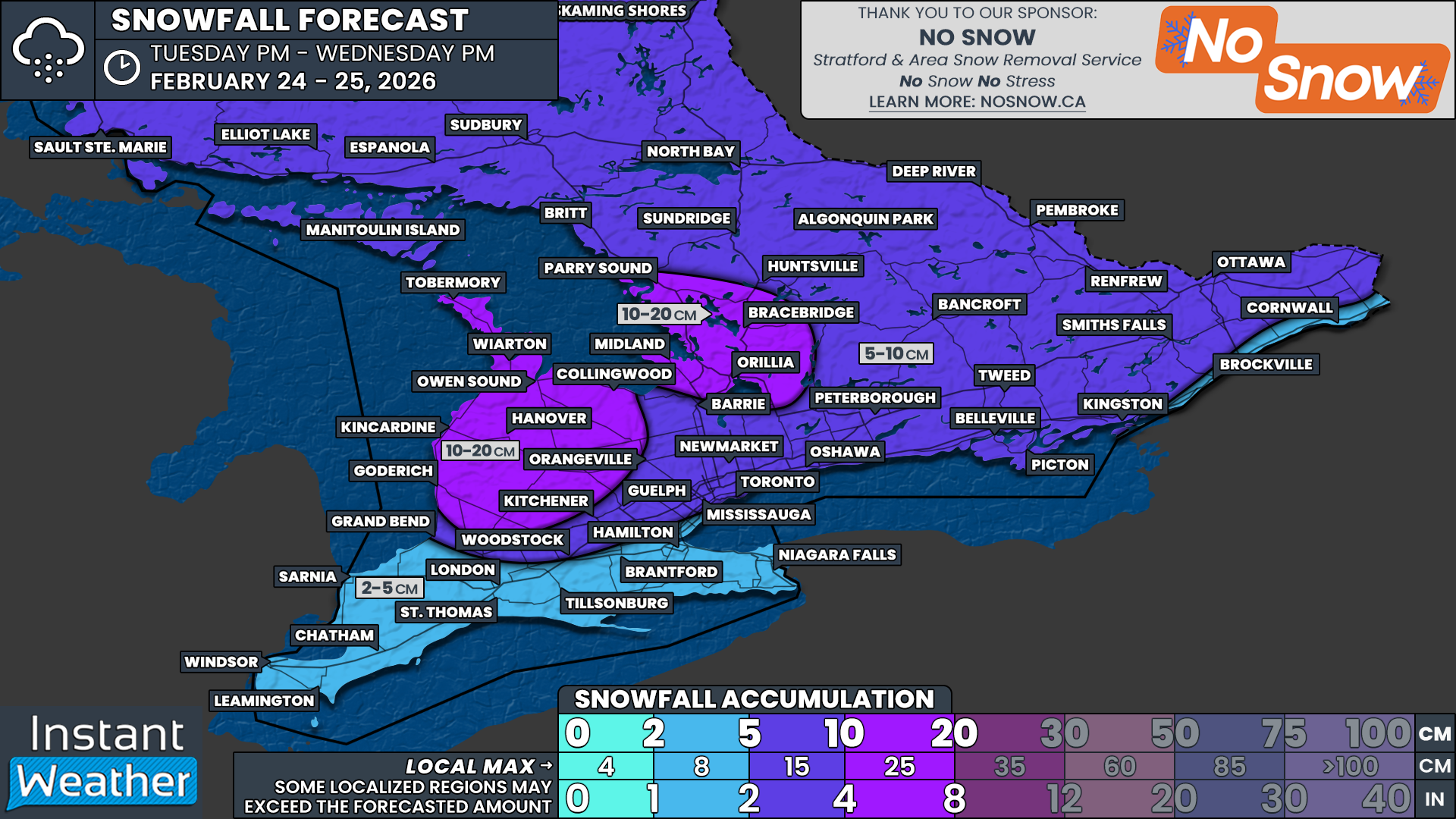
For Northern Ontario, the storm will start as a classic winter system, bringing heavy snowfall to Northeastern Ontario throughout Saturday. A second round of precipitation on Sunday could introduce freezing rain and ice pellets further south, affecting areas like Elliot Lake, Sudbury, and North Bay. Snowfall totals in Northeastern Ontario are expected to range from 20 to 30cm, making travel difficult.

Even the Ottawa Valley will see significant snowfall, with up to 20cm possible, along with a mix of ice pellets. By Sunday, freezing rain could become a concern for the region as temperatures rise and the precipitation type shifts.

PRECIPITATION TYPE - MAP FROM WEATHERBELL

As of Friday afternoon, rain is already moving into Southwestern Ontario. By the evening, precipitation will spread north and east into Central and Eastern Ontario.

Based on the latest data, a band of heavy snow is expected to develop along a corridor stretching from Sudbury through North Bay and into the Ottawa region. To the south, an area of freezing rain will form over the Bruce Peninsula and extend into regions around Lake Simcoe.

ESTIMATED TEMPERATURE - MAP FROM WEATHERBELL

How far south the freezing rain spreads remains uncertain. Model guidance suggests surface temperatures will hover near the freezing mark across Barrie and the Greater Toronto Area (GTA).

Even a fraction of a degree difference could significantly alter how much freezing rain accumulates. If the air remains colder than expected, freezing rain could be more widespread. However, a slightly warmer scenario would push the freezing rain line further north.

Confidence is highest for freezing rain in northern sections of Simcoe County, Kawartha Lakes, and Muskoka. These areas are most likely to remain below freezing for an extended period, allowing heavy ice accretion to build up.

PRECIPITATION TYPE - MAP FROM WEATHERBELL

The most intense icing is expected overnight into early Saturday morning. The worst conditions will stretch from Muskoka through Peterborough and into Kingston.

Once again, temperature will be the deciding factor. Some areas, such as Barrie and Newmarket, sit right on the edge between freezing rain and regular rain. If cold air lingers longer than anticipated, freezing rain could extend as far south as the northern GTA, as well as higher elevations like the Dundalk Highlands.

PRECIPITATION TYPE - MAP FROM WEATHERBELL

Through Saturday morning and afternoon, light to moderate freezing rain or drizzle is expected to persist across portions of Central Ontario, particularly around Lake Simcoe. However, the intensity will decrease compared to the earlier hours.

Further south, rain will continue across Southwestern Ontario and the GTA. This is when we expect the warmest temperatures of the storm. Some areas in Deep Southwestern Ontario, including Windsor, could surge into the 20s, while Central Ontario remains near or below freezing.

PRECIPITATION TYPE - MAP FROM WEATHERBELL

By Saturday evening, another round of heavy precipitation is expected to push into Central Ontario. At the same time, temperatures will steadily drop. Regions that saw rain in the afternoon—including parts of the GTA and Barrie—may transition back to freezing rain.

ESTIMATED TEMPERATURE - MAP FROM WEATHERBELL

Model data suggests that by late Saturday night into Sunday morning, the freezing rain line could shift southwest of the GTA. This could result in several hours of freezing rain across Kitchener, Waterloo, and parts of the Toronto area.

Deep Southwestern Ontario, including Windsor, Sarnia, and London, is expected to remain unaffected, staying well above freezing.

PRECIPITATION TYPE - MAP FROM WEATHERBELL

Sunday morning will bring a gradual transition from freezing rain to regular rain across the GTA as temperatures climb above freezing. However, elevated areas northwest of the city, such as Guelph, Orangeville, and Shelburne, could see freezing rain linger for a few extra hours.

For Central Ontario, the freezing rain will continue into early Sunday afternoon as the main area of precipitation slowly shifts north.

By Sunday afternoon, the Ottawa Valley may begin transitioning from snow to ice pellets and then to freezing rain as temperatures rise.

PRECIPITATION TYPE - MAP FROM WEATHERBELL

Most of Southern Ontario will warm above the freezing mark by late Sunday, finally pushing the freezing rain threat northward.

However, by Sunday night into Monday morning, the risk of freezing rain will shift to Northeastern Ontario, including Sudbury and North Bay.

Meanwhile, heavy snow and ice pellets will impact more northern regions, such as Wawa and Timmins.

NOTE: YOU CAN CLICK ON THE MAP TO OPEN A ZOOMABLE IMAGE

Predicting exact ice accretion remains challenging, as many factors influence how much ice actually builds up. The amount of freezing rain you experience may vary significantly from nearby areas due to microclimate effects, surface conditions, and temperature fluctuations.

Some high-resolution model runs suggest an extreme scenario with localized pockets of over 50mm—possibly even 75mm—of freezing rain. However, because much of this precipitation will fall in a relatively short timeframe, not all of it will necessarily adhere to surfaces.

Given this, we are forecasting general ice accretion between 25 and 40mm in the hardest-hit areas. This includes the northern tip of the Bruce Peninsula, Muskoka, Orillia, Barrie, Orangeville, Collingwood, Lindsay, Peterborough, Belleville, and Kingston.

If temperatures are slightly colder than expected, some locations could exceed 40mm of ice accretion, particularly where conditions allow for more efficient accumulation.

ice storm safety tips

To put this into perspective, we can use the Sperry-Piltz Ice Accumulation Index (SPIA Index). With forecasted ice accumulations of 25-40mm (1-1.4”), this storm falls into a Category 4 ice event—even before factoring in wind.

While we are not expecting extreme winds, gusts of 40-50km/h (25-30 mph) in some areas could push this storm into Category 5 territory. According to the SPIA Index, a Category 5 ice storm results in:

Catastrophic damage to entire exposed utility systems, including both distribution and transmission networks. Outages could last several weeks in some areas. Shelters needed.

For the Greater Toronto Area (GTA), ice accretion amounts will vary significantly. The biggest factor will be how long cold air remains trapped at the surface.

We currently expect between 10-15mm of ice for northern parts of the GTA, including York, Durham, and Peel regions. Kitchener and Waterloo will likely see between 5-10mm.

Closer to the Lake Ontario shoreline—including downtown Toronto—freezing rain amounts should be lower, around 2-5mm. However, if temperatures are colder than expected, ice accretion in the GTA could be higher, so it’s still best to prepare.

To the north, ice accretion amounts will drop off as freezing rain transitions to ice pellets and snow closer to the Ottawa Valley.

NOTE: YOU CAN CLICK ON THE MAP TO OPEN A ZOOMABLE IMAGE

In terms of snowfall, widespread totals between 20-30cm are expected across much of Northeastern Ontario through Monday. This includes Sudbury, North Bay, Chapleau, Timmins, and Kirkland Lake. Even Thunder Bay could see 10-20cm of snow, mainly earlier in the weekend.

Along the Quebec border, snowfall amounts will range from 10-20cm in areas like the Ottawa Valley and Cornwall. Further southwest, freezing rain and ice pellets will be the dominant concern, leading to lower snowfall totals.

This storm remains highly dynamic, with small temperature fluctuations potentially making a massive difference in what type of precipitation falls. We will continue to monitor the latest data and provide updates as the situation evolves. Stay safe and stay prepared.

Potential Major Ice Storm Threat on the Horizon for Southern Ontario This Weekend

NOTE: YOU CAN CLICK ON THE MAP TO OPEN A ZOOMABLE IMAGE

With the end of March approaching and the arrival of April, winter’s grip on Southern Ontario is loosening. However, Old Man Winter isn’t leaving quietly. Instead, the final days of March bring the potential for multiple rounds of heavy freezing rain across parts of the region.

The risk of freezing rain is set to begin late Friday as the first wave of precipitation moves in. This initial bout of freezing rain could be quite heavy at times, particularly across Central and Southern portions of Eastern Ontario. The Greater Toronto Area (GTA) may also see some freezing rain late Friday before transitioning to regular rain as temperatures rise overnight.

A second wave of freezing rain is expected to develop Saturday evening and continue through Sunday. However, this round carries more uncertainty, with forecast models disagreeing on how far north warm air will push at the surface. Some models concentrate the freezing rain in Northeastern Ontario and the Ottawa Valley, while others bring it much farther south, placing the GTA in the bullseye.

While there is still uncertainty regarding the exact track and intensity of the freezing rain, all major weather models agree on the overall setup. Cold air will remain locked in at the surface across parts of Southern Ontario, while a surge of warm air moves in aloft. This combination will create ideal conditions for freezing rain formation.

These conditions are expected to persist throughout much of the weekend, with multiple waves of freezing rain possible. Given the prolonged duration of freezing rain, significant impacts are likely. Thick layers of ice could accumulate on untreated surfaces, including trees and power lines. The weight of this ice may lead to substantial damage to the power grid, with outages that could take days—or even weeks—to repair.

PRECIPITATION TYPE - MAP FROM WEATHERBELL

Focusing on the first round, models are beginning to develop a clearer picture of where freezing rain will be most intense. Initial bands of precipitation should move into Southwestern Ontario by late Friday afternoon or evening.

As this precipitation reaches areas such as Kitchener, Owen Sound, and Barrie, it will encounter stubborn below-freezing temperatures at the surface. This will lead to freezing rain developing across these regions.

Further north, a band of heavy snow is expected to spread across areas near the northern shoreline of Lake Superior, extending into Timmins. In more southern locations, such as Sault Ste. Marie, Sudbury, and North Bay, ice pellets will likely be the dominant form of precipitation.

PRECIPITATION TYPE - MAP FROM WEATHERBELL

Models agree that warm air associated with this system will gradually work its way toward the surface, beginning in the southwest and pushing northeast through the night. As a result, some freezing rain may mix with regular rain, especially southwest of Lake Simcoe and near the Lake Ontario shoreline in the GTA.

The persistence of cold air at the surface remains a major question mark. Some models suggest that cold air will be more stubborn, leading to more sustained freezing rain in the GTA overnight and into Saturday morning.

What is more certain is that a particularly intense band of freezing rain will set up over Central Ontario, including the Bruce Peninsula, Muskoka, Simcoe County, Peterborough, and Kingston. Significant ice accumulation is expected in these areas, with freezing rain continuing into Saturday morning. While freezing rain will persist into the afternoon, it should gradually become more scattered in nature.

In the Ottawa Valley, ice pellets and snow will be the main concern. There remains uncertainty regarding snowfall totals, as accumulation will depend on how much mixing occurs with ice pellets. Estimates currently range from 10 to 20 cm, but if ice pellets dominate, snowfall amounts could be closer to 5 cm.

TEMPERATURE - MAP FROM WEATHERBELL

Looking at the temperature setup for this event, a sharp gradient will be present across Southern Ontario on Saturday morning. This is one of the factors making this forecast so tricky.

Below-freezing temperatures will be well-established over Central and Eastern Ontario, as indicated by areas northeast of the pink line on the map above. Meanwhile, Deep Southwestern Ontario—including Windsor, Sarnia, and London—will experience double-digit temperatures, with no threat of wintry precipitation.

The most uncertain area lies between the orange and pink lines on the map above. This includes much of the GTA and the Grey-Bruce region. Temperatures in these areas will hover near the freezing mark, placing them at the boundary between warm and cold air. If models are off by just a degree or two, it could mean the difference between an ice storm and plain rain.

NOTE: YOU CAN CLICK ON THE MAP TO OPEN A ZOOMABLE IMAGE

This represents our preliminary assessment of the hardest-hit areas from the first round of freezing rain. It’s important to note that this forecast covers conditions through Saturday night, but the threat of freezing rain will persist into Sunday and even Monday. There is less certainty regarding how the second round will play out, so our focus remains on the first round for now.

Confidence is highest for significant ice storm impacts in locations such as Tobermory, Wiarton, Owen Sound, Collingwood, Orangeville, Barrie, Midland, Orillia, Muskoka, Parry Sound, Peterborough, and Kingston. Ice accretion in these areas will likely exceed 10 mm and could even reach 20 to 30 mm in the worst-case scenarios.

As previously discussed, temperatures will play a crucial role in determining the extent of freezing rain along the narrow corridor that includes the GTA and Kitchener. Slightly colder temperatures could mean prolonged freezing rain, while a warmer solution would allow for a quicker transition to rain overnight Friday.

Those in Deep Southwestern Ontario and along the Lake Erie shoreline should see little impact, as temperatures will remain well above freezing, resulting in plain rain rather than freezing precipitation.

For more northern regions along the Quebec border, ice pellets and snow will be the dominant precipitation types. Locations such as North Bay, Pembroke, and Ottawa could see 10+ cm of snow, with a risk of ice pellets and possibly brief periods of freezing rain.

PRECIPITATION TYPE - MAP FROM WEATHERBELL

As the first round of freezing rain winds down across Southern Ontario, lingering pockets of freezing drizzle may persist across Central and Eastern Ontario through Saturday afternoon. In the GTA, temperatures could dip just enough to allow for a transition back to freezing rain later in the day.

The second round of freezing rain is expected to arrive by Saturday evening as energy moves in from the U.S. Midwest.

PRECIPITATION TYPE - MAP FROM WEATHERBELL

Models are in solid agreement that this second wave will set up another band of freezing rain in the same areas hit hardest by the first round, including Central Ontario and portions of the GTA. This freezing rain will persist overnight into Sunday morning. However, by Sunday morning, the models begin to diverge significantly.

A more northern track would see warm air winning out across Southern Ontario, allowing temperatures to rise and leading to a transition to rain near Lake Simcoe. This would push the freezing line northward into Northeastern Ontario and the Ottawa Valley. In this scenario, freezing rain would be confined to areas such as Sudbury and North Bay, while heavy snow would develop from Wawa to Timmins.

Both the Canadian and European models favor this northern solution, which would be the better outcome for Southern Ontario, as it would avoid a second major icing event. However, this would be worse news for Sudbury and North Bay, where a significant ice storm could unfold.

PRECIPITATION TYPE - MAP FROM WEATHERBELL

This more northern track has the warmer air winning out across Southern Ontario during the morning on Sunday. This gradually leads to a switch over to rain near Lake Simcoe as the freezing line puches north into Northeastern Ontario and the Ottawa Valley.

Then freezing rain would be contained to Northeastern Ontario including Sudbury and North Bay. While heavy snow extends from Wawa to Timmins.

Both the Canadian and European models favor this solution. Which would certainly be the better outcome for Southern Ontario as they escape a second icing event. But would be worst news for Sudbury and North Bay which could see an ice storm.

PRECIPITATION TYPE - MAP FROM WEATHERBELL

On the other hand, the American model suggests a much more southerly track, which would place Southwestern Ontario and the Golden Horseshoe directly in the path of heavy icing. This scenario would bring freezing rain through Sunday night into Monday morning, creating hazardous conditions for the Monday morning commute.

If this outcome materializes, widespread school bus cancellations across Southern Ontario would be likely on Monday morning. Meanwhile, areas farther north could see accumulating snow on top of earlier ice buildup.

Unfortunately, a significant cooldown is expected in the wake of this storm. By Monday evening, temperatures will plunge into the negative teens. Any ice that accumulates over the weekend will remain in place for several days, increasing the strain on the power grid as trees continue to fall onto power lines.

Regardless of how this storm unfolds, it is shaping up to be a high-impact winter event with potentially severe consequences in some areas. Prepare for treacherous travel conditions and the possibility of widespread power outages lasting multiple days.

We will provide further updates as the weekend approaches. Stay tuned and stay safe!

First Isolated Severe Thunderstorm Risk of the Season for Parts of Southern Ontario Sunday Afternoon and Evening

NOTE: YOU CAN CLICK ON THE MAP TO OPEN A ZOOMABLE IMAGE

It’s certainly been a while since we’ve had an isolated risk for severe thunderstorm activity in Southern Ontario, but here we are! Welcome to Spring! What we’re expecting is a line of thunderstorms and based on the time I’m writing this (11:11am), it looks like it has already begun to develop over Lake Erie. This line will continue to push to the northeast, affecting the Niagara Region and potentially all the way up to Barrie and parts of Simcoe County.

RADAR IMAGE FROM 11:12 AM EDT - MAP FROM INSTANTWEATHER PRO

Taking a look at the IW Pro app screenshot above, you can see the thunderstorm line beginning to develop over Lake Erie. We’re expecting nickel-size hail (perhaps a bit larger), strong wind gusts, torrential rain and frequent lightning with this line. Additionally, you can see a red outline of a Tornado Watch south of the border that covers areas south of Lake Erie.

An isolated tornado cannot be entirely ruled out with this system slipping past the international border and tracking into Ontario, so we’ll be keeping a very close eye on radar today. If you don’t already have our free app, InstantWeather, today may be a good day to download it so we can notify you of any rotating storms, funnel cloud reports or Environment Canada alerts.

Some models have also shown some very intense wind gusts, potentially exceeding 100km/h, especially in eastern Ontario, so we’re fairly concerned with that potential. Being an early season event, we decided to go with a Marginal (green) risk, but there certainly is a chance these storms could exceed the Slight (yellow) threshold, especially with the wind risk.

MAX WIND GUST FORECAST FROM THE HRRR MODEL - MAP FROM WEATHERBELL

In the image above, we see the HRRR model’s maximum wind gust forecast for Southern Ontario, showing some very strong winds in yellow and orange. This is just one model’s output so it’s not a guarantee. Nonetheless, if wind gusts do reach these levels, even in isolated areas, we could end up seeing some fairly strong wind damage to trees, hydro polls or perhaps even structures.
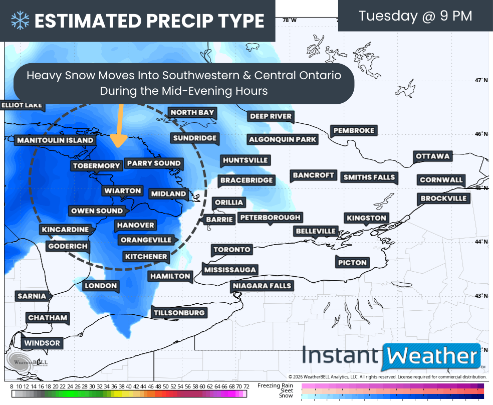
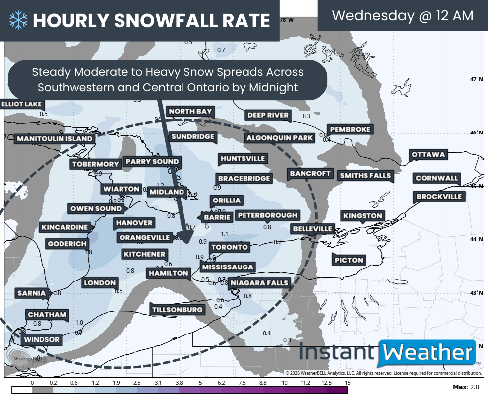
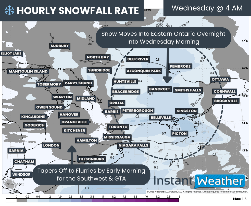
The main risk, timing wise, should begin this afternoon in the Niagara Region, with storms moving northeast from Lake Erie and that risk should continue to spread northeast into the evening hours. Generally, our main concern is for Niagara and areas north and east of Lake Ontario into eastern Ontario. However, we have highlighted parts of Southwestern Ontario, the GTHA, and Central Ontario as well, as we’ve seen some model data suggesting strong wind gusts are possible in those regions, along with hail, torrential rain, isolated flooding, frequent lightning and a small risk of an isolated tornado.
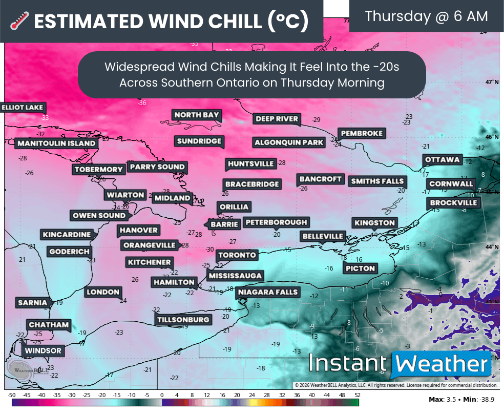
In general, the tornado risk is quite isolated. Having said that, with a potent system south of the border, there is always a chance we could see some tornado activity sneak into Ontario and based on some of the model data we’ve seen over the past couple of days, the risk of a spin-up or two cannot be ruled out.

We do plan on doing a livestream if storms continue to look strong this afternoon and evening so make sure to subscribe to our YouTube channel in order to get notified if and when we go live!

We’ll be posting more updates to our social media pages as well so if you’re on Facebook, you can find us at Ontario Storm Watch. We also have a fantastic storm reporting group on FB with Ontario Storm Reports. And if you’re on X/Twitter, you can find us at @IWeatherON.

More details ASAP and stay safe today, folks!

- Adam