Southern Ontario to Plunge Into Winter as Sunday Snowstorm Could Dump Up to 20 cm of Snow
/

NOTE: YOU CAN CLICK ON THE MAP TO OPEN A ZOOMABLE IMAGE
It feels like just yesterday we were talking about record-breaking heat that stretched well into October. But November has been a completely different story, with winter now making its presence known across Southern Ontario. Those warm late-autumn days are coming back to haunt us, as the still-warm lakes are setting the stage for a series of snowy chances in the days ahead, including the lake effect snow machine coming to life.
Cold Arctic air is set to flood into the province, bringing several snowmakers with it, including a potential snowstorm on Sunday, followed by intense snow squalls early next week.
Our first system arrives on Friday, spreading across Ontario throughout the day. Southern Ontario will mainly see rain from this one, while Northern Ontario braces for a significant dumping of snow. Some areas could see close to 20 cm by Saturday.
As colder air rushes in behind this system, temperatures will plunge across Southern Ontario through Saturday night. By Sunday, much of the region will be below freezing, setting the stage for the next system expected to move in during the day Sunday. Early indications suggest that parts of Southern Ontario could see significant snowfall from this system, with totals possibly reaching up to 20 cm by Sunday night.
That said, there’s still plenty of uncertainty surrounding the exact track of the storm. A slightly more southern route could pull the heaviest snow into the Greater Toronto Area as colder air dips farther south.

PRECIP TYPE - MAP FROM WEATHERBELL
The first round of precipitation will begin in Northwestern Ontario late Thursday, spreading across Northeastern and Southern Ontario by Friday morning.
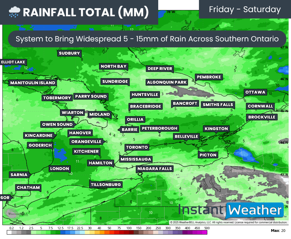
RAINFALL TOTALS - MAP FROM WEATHERBELL
For most of Southern Ontario, this will mean a steady rainfall, with totals around 5 to 10 mm, although localized pockets near the lakes could see closer to 15 mm.
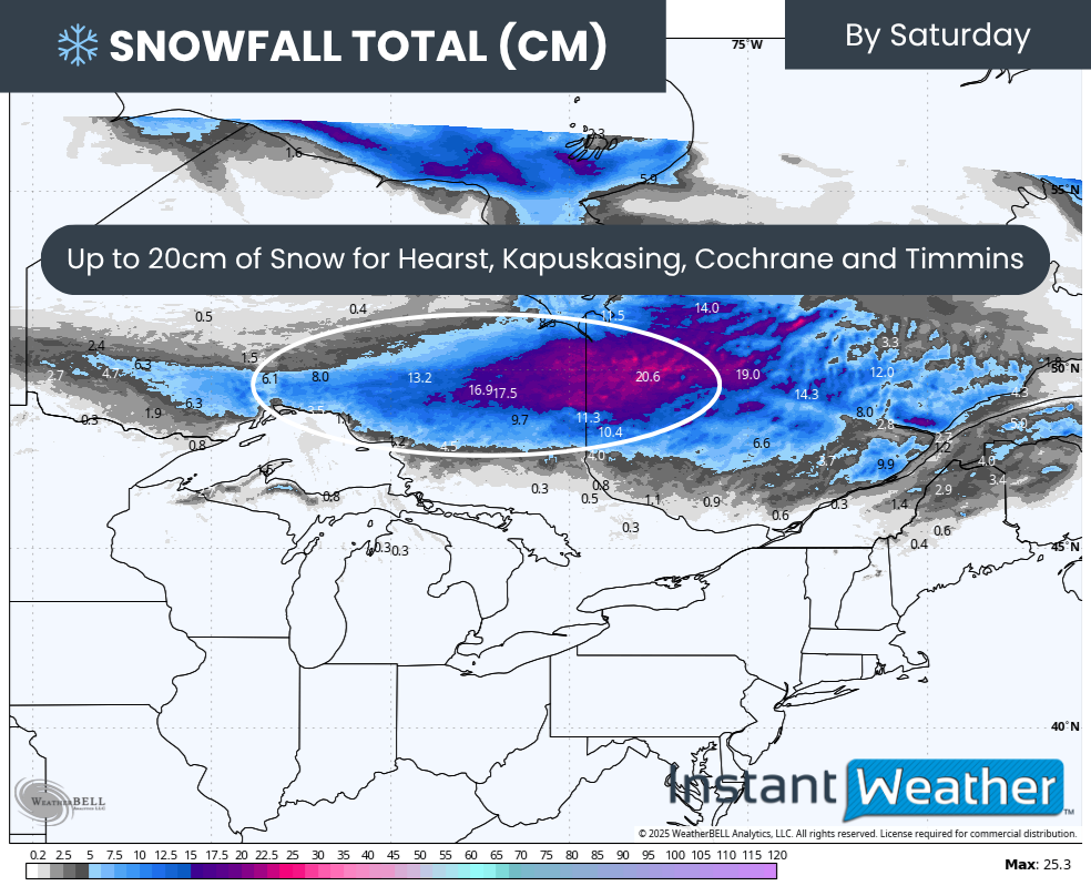
SNOWFALL TOTALS - MAP FROM WEATHERBELL
Higher elevations in Central Ontario, including Algonquin Park, could see some wet flurries mix in at times. Farther north, around Hearst, Kapuskasing, Cochrane, and Timmins, it’s all snow, with totals of 15 to 20 cm possible by Saturday morning.

TEMPS - MAP FROM WEATHERBELL
Behind the system, much colder air will spill into Central Ontario overnight Friday into Saturday, dropping temperatures well below freezing. The rest of Southern Ontario will see the chill arrive soon after, with most regions seeing their daytime highs recorded just after midnight Saturday before temperatures tumble through the day.

TEMPS - MAP FROM WEATHERBELL
By early Sunday morning, the cold will be firmly in place. Most areas will be below freezing, except for parts of Deep Southwestern Ontario and along the Lake Ontario shoreline where temperatures will hover just above zero.

PRECIP TYPE - MAP FROM WEATHERBELL
This cold setup will pave the way for Sunday’s incoming system. Models are in disagreement about the storm’s path, which will ultimately decide who gets the heaviest snow. The American and Canadian models track the low across Lake Erie and Lake Ontario, placing the rain-snow line near the GTA.
In this scenario, areas north of the GTA, including parts of Southwestern Ontario, Lake Simcoe, and the Ottawa Valley, would see heavy snow, while the GTA experiences a mix of rain, ice pellets, and wet snow.
PRECIP TYPE - MAP FROM WEATHERBELL
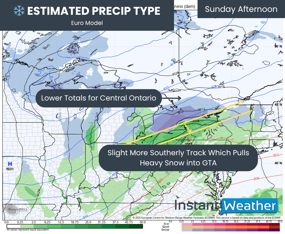
Even a small shift southward, as suggested by the European model, would change everything. That track takes the low through Pennsylvania and Upstate New York, shifting the heaviest snowfall into the GTA and surrounding regions, with totals over 15 cm.

SNOWFALL TOTALS - MAP FROM WEATHERBELL
In this case, the snow would stretch from London through the GTA, Peterborough, and into Ottawa, while Central Ontario and Grey-Bruce see lower amounts.
NOTE: YOU CAN CLICK ON THE MAP TO OPEN A ZOOMABLE IMAGE

For now, most models favour the northern track, so that’s what we’re leaning toward in our preliminary forecast. But if the European solution proves right, those snowfall zones could shift south before the final forecast is issued.
Under the current setup, the heaviest snow is expected across a broad stretch of Southwestern Ontario, including the Lake Huron shoreline through Kitchener and up toward Barrie, Lindsay, and Peterborough, extending into the Ottawa Valley. These areas could see 10 to 15 cm of snow, with localized pockets near 20 cm possible.
The American NAM model is even more aggressive, suggesting up to 30 cm in some areas, though that’s likely overdone. The London area, GTA, and Eastern Ontario fall into a mixing zone, with 5 to 10 cm possible once precipitation switches to snow. Should the system shift farther south, those totals could increase.
Farther south, places like Windsor, Chatham, Sarnia, and the Niagara Region are expected to stay mostly rain, though a slushy 5 cm of snow is possible.
Snowfall will taper off by late Sunday, but the story won’t end there. Behind the storm, a strong surge of cold air over the still-warm Great Lakes will ignite a burst of lake-effect snow squalls on Monday.
The exact regions that will see the most intense squalls remain uncertain until higher-resolution models come into range, but areas downwind of Lake Huron and Georgian Bay should prepare for the potential of significant accumulations. Some communities could be digging out from 25 cm or more by early next week.