Potential Boxing Day Winter Storm Targets Southern Ontario With Significant Freezing Rain Risk and Up to 15-20cm of Snow
/
NOTE: YOU CAN CLICK ON THE MAP TO OPEN A ZOOMABLE IMAGE
While winter weather has mostly taken a breather across Southern Ontario over the past week, things are about to turn active again as we head into the final days of 2025.
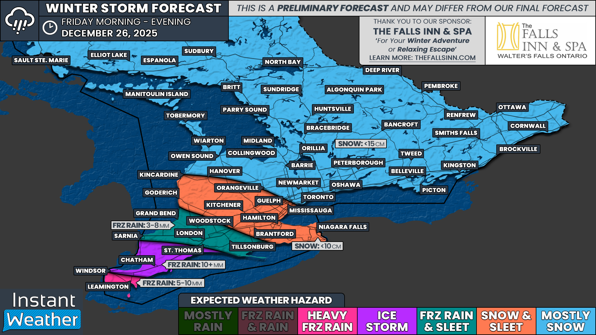
That change begins on Boxing Day with a messy winter system expected to slide through Southern Ontario. This system will bring a wide range of hazards, including the threat of significant freezing rain in Deep Southwestern Ontario and more widespread snowfall across much of the rest of the region.
There are still some question marks surrounding this storm, particularly when it comes to how strong it ultimately becomes. Some lower-resolution models show a fairly robust system with plenty of moisture to work with. At the same time, higher resolution guidance that is now coming into range is hinting at some drier pockets, which could cause this system to underperform in spots.
Complicating matters further is the fact that this system has the characteristics of an Alberta Clipper. Clippers are notorious for being difficult to forecast since they often lack a deep source of moisture, and small changes can make a big difference in precipitation type and totals.
What we do know at this point is that impacts will vary significantly across Southern Ontario. The highest risk area continues to be Deep Southwestern Ontario, especially the Windsor, Chatham and Sarnia region, which currently sits in the bullseye for prolonged freezing rain.
In these areas, sustained freezing rain could lead to substantial ice accretion on roads, trees and power lines. This would result in dangerous travel conditions and an increased risk of power outages. With over 10mm of icing possible, there is also concern for widespread tree damage as branches struggle under the weight of the ice.
Further north, from areas east of Lake Huron through the Greater Toronto Area and into Central and Eastern Ontario, the primary precipitation type is expected to be snow. Snow will fall steadily through much of the day on Friday with general accumulations of 5 to 15cm by the end of the day. Locally higher amounts approaching 20cm are possible west of Lake Ontario around the Toronto area due to lake enhancement.
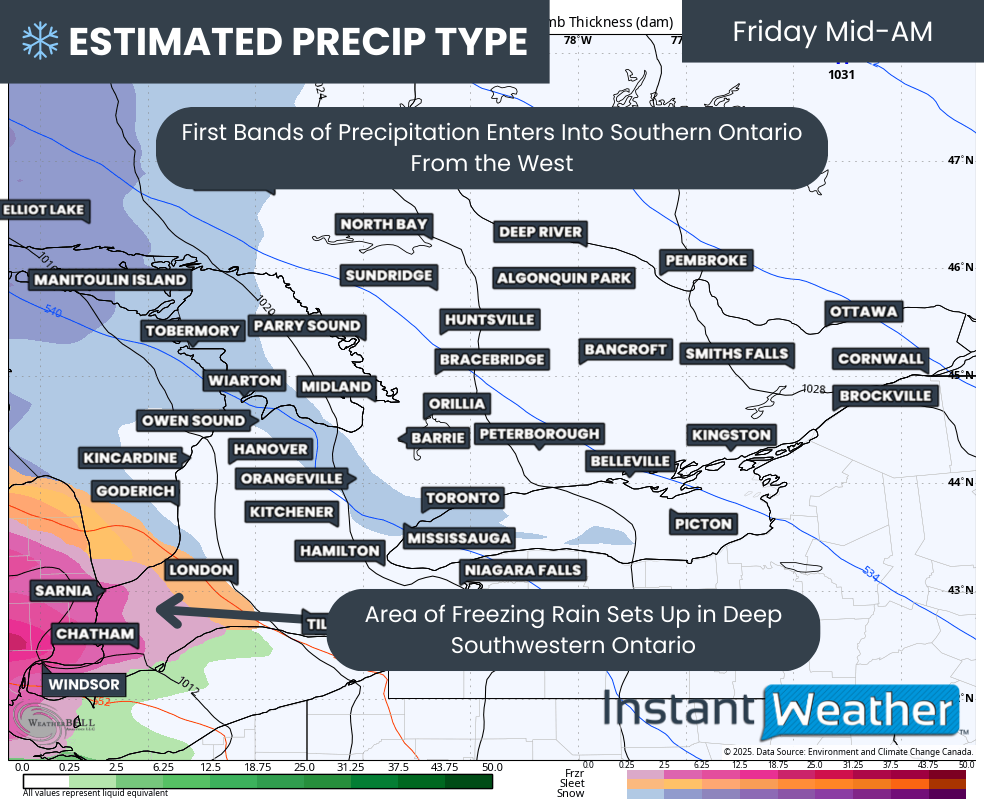
PRECIP TYPE - MAP FROM WEATHERBELL
The first bands of precipitation are expected to arrive early to mid-morning on Friday, spreading across Lake Huron into Southwestern Ontario. As the system moves in, it will encounter a stubborn layer of cold air near the surface across Deep Southwestern Ontario, including Windsor, Leamington, Chatham and Sarnia.
At the same time, warmer air will surge in above the surface, creating a classic setup for freezing rain. This warm layer aloft melts the snow into rain, which then freezes on contact with cold surfaces at the ground.
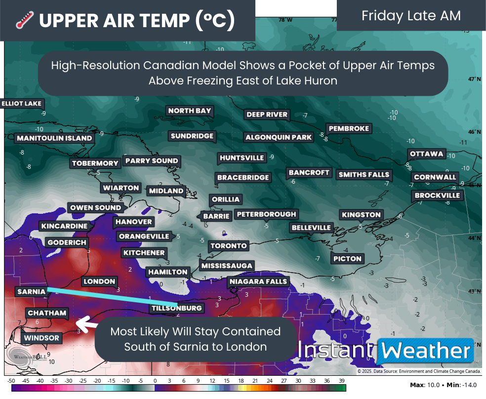
850MB TEMPS (1.5KM ABOVE GROUND) - MAP FROM WEATHERBELL
The biggest challenge with events like this is determining how far north and how deep that warm layer extends. This is the key factor that decides whether precipitation falls as ice pellets or as freezing rain.
Temperatures roughly 1.5km above the surface vary considerably between models. The Canadian model is more aggressive, pushing the warm layer farther north into Southwestern Ontario and even as far as London.
Overall, model consensus places the freezing line somewhere near a Sarnia to London corridor. Areas south of this line are more likely to see freezing rain, while areas to the north will see a mix of ice pellets and snow.
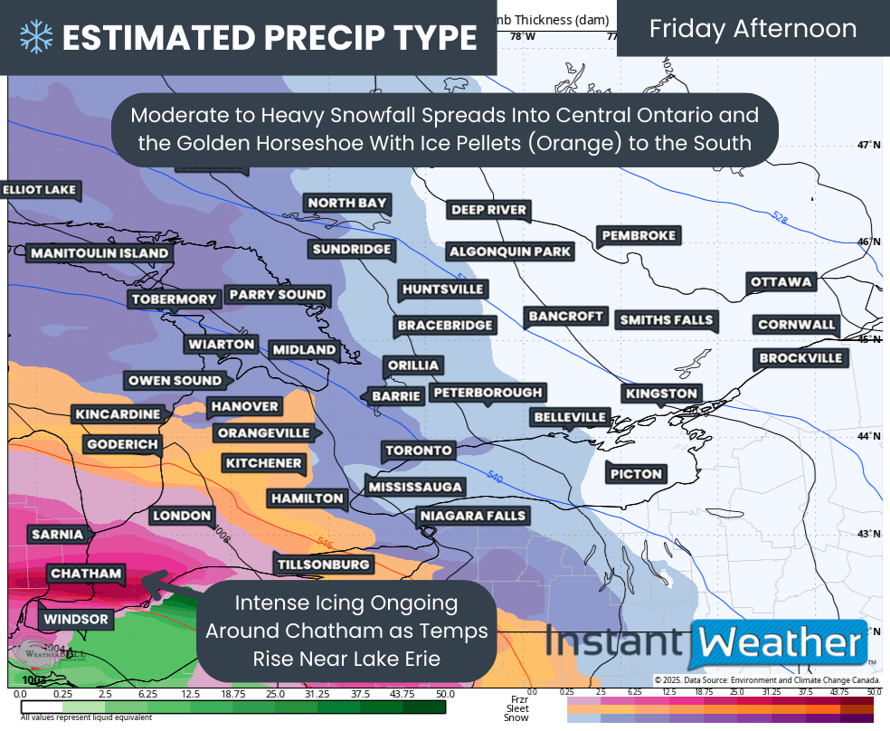
PRECIP TYPE - MAP FROM WEATHERBELL
By the early afternoon, heavier snow will begin spreading into Central Ontario and the Golden Horseshoe as precipitation from Northern Ontario moves southeast across Georgian Bay. At the same time, freezing rain will be ongoing around Windsor, Chatham and Sarnia.
There are indications that temperatures may slowly climb above freezing for southern Essex County, including Leamington and eventually Windsor. There is still disagreement on the exact timing of this changeover, but it appears most likely sometime during the early to mid-afternoon.
If temperatures do rise above freezing, freezing rain would switch to plain rain, and any ice accretion would begin to melt. How quickly this happens will be critical in determining overall impacts. If the warmup is delayed until later in the day or temperatures stubbornly remain below freezing before dropping Friday night again, impacts could be significantly worse.
For areas like Chatham-Kent, Sarnia and St. Thomas, there is growing concern that temperatures may remain below freezing for much of the event. This would allow ice to accumulate for a prolonged period, with over 10mm of accretion possible. Ice amounts of this magnitude are capable of bringing down tree limbs and power lines, potentially leading to power outages that could last for several days.
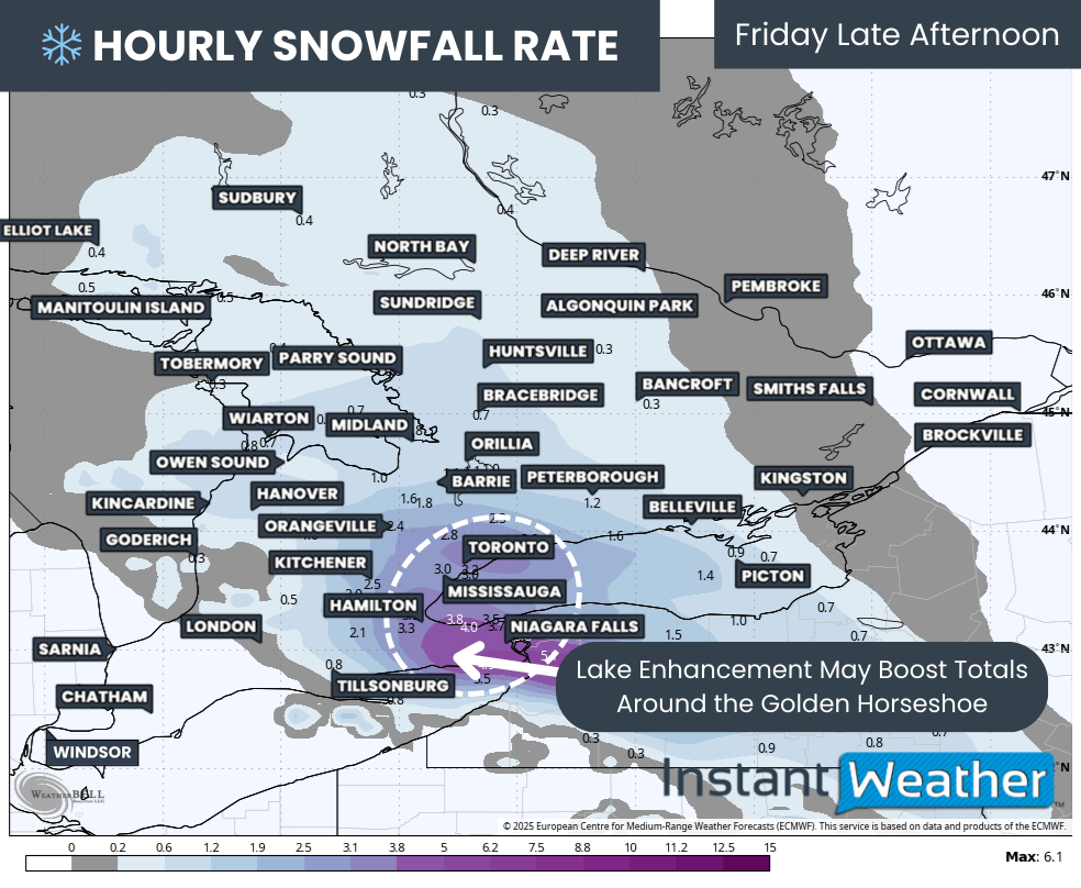
Hourly snowfall rates (cm) - MAP FROM WEATHERBELL
By mid-afternoon, the heaviest snow will be pushing through the Golden Horseshoe. Some models are showing the potential for lake enhancement along the Lake Ontario shoreline from Niagara through Hamilton and into Toronto. If this develops, snowfall rates could briefly spike to 3 to 5cm per hour compared to the more general 1 to 2cm per hour elsewhere.
It is also important to note that ice pellets may mix in at times, which can limit snowfall totals since ice pellets are denser than snow. This is most likely for areas such as London, Kitchener, Hamilton and Niagara, where conditions are more supportive of mixed precipitation. Areas closer to Toronto and farther north into Central Ontario should see more consistent snow.
Light to moderate snow will also spread into Eastern Ontario by the afternoon and continue into the evening before tapering off around midnight. Confidence in snowfall totals here is lower, but amounts in the 5 to 10cm range appear possible by the end of the day.
NOTE: YOU CAN CLICK ON THE MAP TO OPEN A ZOOMABLE IMAGE

While there is decent agreement on the overall track of this system, fluctuations are still very likely. Freezing rain events are among the most difficult to forecast, and even small temperature changes can have major impacts.
At this time, the highest confidence for the worst impacts remains across the Chatham, Windsor and St. Thomas area, where a persistent band of freezing rain is expected to set up for much of the day on Friday. Some models show up to 20mm of liquid precipitation, though not all of that would freeze on surfaces. For now, we are forecasting over 10mm of ice accretion, with the understanding that an overachieving scenario is still on the table.
For southern Essex County, including Leamington and possibly southern Windsor, ice accretion of 5 to 10mm is possible before a changeover to rain. Because of this transition, overall impacts should be lower compared to areas farther north, where freezing rain may last longer.
Farther north, from Sarnia through London and into Norfolk County, precipitation may begin as ice pellets in the morning before transitioning to freezing rain later in the afternoon or early evening. Ice accretion here could range from 3 to 8mm, depending on how quickly this transition occurs.
A corridor stretching from Goderich through Kitchener, Hamilton and into the Niagara region is expected to start with heavier snow Friday afternoon. Mixing with ice pellets later in the day could reduce snowfall totals, with most areas seeing around 5 to 10cm by the end of the event.
Areas that remain predominantly snow from start to finish include Grey-Bruce, much of Central Ontario, Eastern Ontario and the eastern portions of the GTA. Snowfall totals here should generally range from 10 to 15cm, with localized amounts up to 20cm. In Eastern Ontario, especially closer to the Quebec border, totals may struggle to reach 10cm, making 5 to 10cm a more realistic expectation.
We will continue to monitor the latest data closely and will have a more detailed and refined forecast on Thursday night. That update will provide a clearer breakdown of precipitation types and expected amounts. Be sure to check back for the final forecast.


