Significant Winter Storm For Parts of Ontario Possible This Weekend Says Environment Canada
/NOTE: YOU CAN CLICK ON THE MAP TO OPEN A ZOOMABLE IMAGE
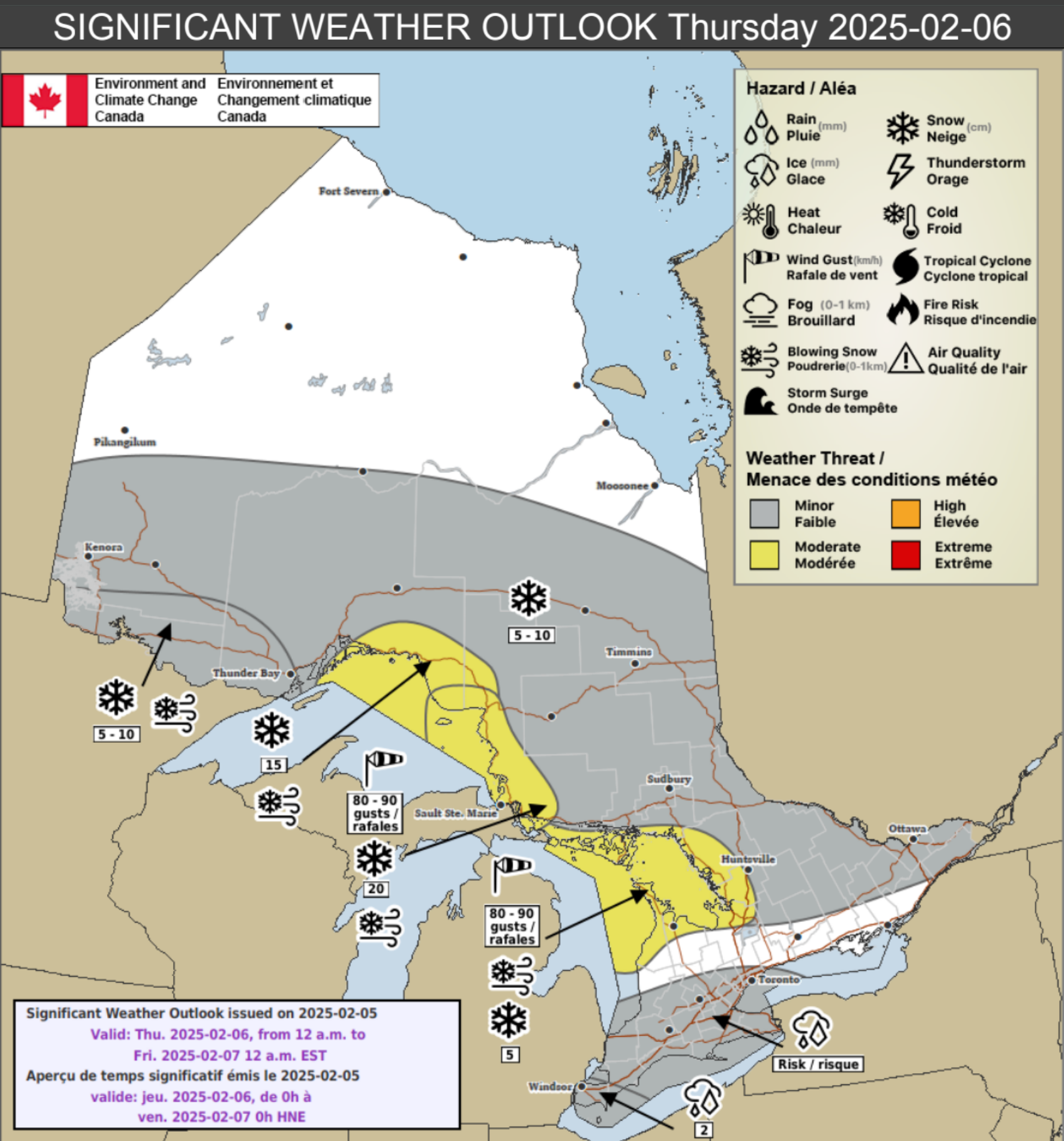
A prolonged and dynamic winter storm is set to impact Ontario beginning Thursday, bringing a combination of heavy snow, strong winds, freezing rain, and hazardous travel conditions across multiple regions. Confidence remains high that this system will bring significant impacts, but uncertainty exists regarding the precise track and intensity of each hazard. Here’s what to expect:
Thursday, February 6, 2025
East of Lake Superior
A powerful winter storm will bring heavy snowfall, strong winds, and widespread blowing snow, making travel extremely hazardous. Whiteout conditions are possible, particularly in open areas.
Wind gusts up to 90 km/h, especially near Lake Superior
Widespread snowfall with lake effect snow contributing to accumulations up to 20 cm
Power outages likely due to strong winds and heavy snow
Winds should ease late Thursday night into Friday morning
Manitoulin Island, Grey/Bruce Region, and East of Georgian Bay
Strong winds and blowing snow will create dangerous conditions across these regions Thursday evening, with near-zero visibility in exposed areas.
Wind gusts up to 90 km/h possible near Lake Huron and Georgian Bay
Loose snow and strong winds will result in blowing snow and whiteout conditions
Winds will ease Thursday night into Friday
North of Lake Superior
A strong snow system will move in during the morning and afternoon, leading to difficult travel conditions.
Snowfall amounts up to 15 cm
Local blowing snow may further reduce visibility
Northern and Far Northern Ontario
Snow and blowing snow will create hazardous conditions early Thursday morning, with worsening visibility in the afternoon as winds increase.
Snowfall amounts up to 10 cm
Wind gusts up to 60 km/h will lead to blowing and drifting snow, making travel difficult
Southwestern Ontario and the Greater Golden Horseshoe
A wintry mix of freezing rain and freezing drizzle could create slippery conditions overnight Wednesday into Thursday afternoon.
Areas around Windsor are at the highest risk of accumulating freezing rain
Icing may also occur across much of southern Ontario due to freezing drizzle mixed with snow
Roads and sidewalks could become extremely slick before temperatures rise above freezing later in the day
Northern, Central, and Eastern Ontario
A broad swath of snow will move through these regions overnight Wednesday into Thursday, leading to travel disruptions.
Snowfall amounts of 5 to 10 cm expected
Friday, February 7, 2025
Areas Southeast of Lake Superior
Lake effect snow squalls will take hold Thursday night and persist into Friday night, producing locally heavy snowfall and whiteout conditions.
Snow accumulations of 15 to 25 cm possible
Wind gusts up to 70 km/h will create blowing snow and significantly reduced visibility, especially Friday morning
Road closures may occur in some areas
Bruce Peninsula and Areas Southeast of Georgian Bay
Similar to regions southeast of Lake Superior, lake effect snow squalls will develop early Friday and continue into the evening.
Snowfall accumulations of 10 to 20 cm possible
Winds gusting to 70 km/h will result in blowing snow and travel disruptions
Southern Ontario from Goderich to Oshawa
Brief but intense snow squalls combined with strong winds may create periods of dangerous driving conditions overnight Thursday into early Friday.
Winds gusting to 70 km/h could cause visibility to drop suddenly in blowing snow
Conditions should improve by Friday morning
Prince Edward County
Strong winds will sweep through Friday morning, potentially causing minor damage and tossing unsecured objects.
Wind gusts up to 80 km/h expected
Saturday, February 8, 2025
Southern Ontario
A new low-pressure system is expected to move into the region Saturday afternoon, bringing additional snowfall that will persist into Sunday morning.
Snowfall amounts near 5 cm Saturday evening, with more possible Sunday
Some uncertainty remains regarding the timing and track of this system
Sunday, February 9, 2025
Southern Ontario West of Oshawa
The storm system from Saturday will continue into Sunday, bringing a second round of snowfall.
Another 5 to 10 cm of snow is expected Sunday morning
Total snowfall accumulations of 10 to 15 cm possible
Difficult travel conditions anticipated
Southern Ontario North of Lake Ontario
A winter system will deliver a widespread snowfall event beginning Saturday evening and lasting into Sunday morning.
Snowfall accumulations of 10 to 15 cm possible
Uncertainty remains regarding the track, which may impact snowfall amounts
While some uncertainties remain regarding the exact intensity and placement of snowfall, wind gusts, and freezing rain, confidence is increasing that Ontario will experience a prolonged and high-impact winter event. Those with travel plans should closely monitor forecasts, as conditions may deteriorate quickly.
We’ll continue to provide updates as more details become available. Stay safe and stay prepared!
Disclaimer: These forecasts are issued by Environment Canada and typically published via their Twitter/X accounts. We receive these forecast via a daily email and often publish them for our communities to see.


