Impactful Winter Storm Possible Says Environment Canada For Parts of Ontario This Week With the Risk of Heavy Snow, Ice, and Dangerous Travel Conditions
/Environment Canada is forecasting a potentially impactful winter storm for parts of Ontario that could bring a mix of heavy snow, freezing rain, strong winds, and dangerous travel conditions. Potentially hazardous winter weather could begin as early as Wednesday evening and continue into the weekend with snow squalls behind the main system. Some areas could see snowfall totals exceeding 30 cm, while others may face icy conditions due to freezing rain. Blowing snow and strong winds could lead to whiteout conditions, power outages, and road closures. While there remains quite a bit of uncertainty in the exact track and intensity of this storm, it’s certainly worth discussing and paying attention to over the next few days.
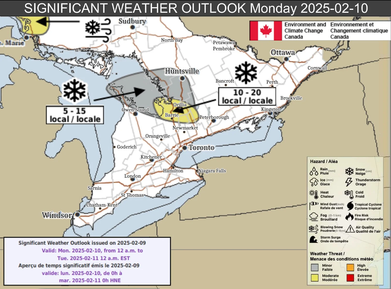
Monday, February 10, 2025
Sault Ste. Marie North to Montreal River Harbour
Hazard(s): Snow, blowing snow
Timing: Overnight into Monday
Impact(s): Hazardous travel conditions, reduced visibility, and road closures.
Confidence: Moderate
Impact: High
Details: Snow squalls will continue through Monday, with some areas receiving an additional 30 cm. Winds will increase Monday afternoon, producing blowing snow. Snow squalls will taper off before Tuesday morning.
Agawa – Lake Superior Park
Hazard(s): Snow, blowing snow
Timing: Afternoon and evening
Impact(s): Difficult travel conditions, reduced visibility, and possible road closures.
Confidence: Low
Impact: Moderate
Details: Snow squalls south of the area may move north Monday afternoon, with local snowfall amounts of 5 to 15 cm possible before they shift back south Monday evening. Winds will increase Monday afternoon, producing blowing snow.
Regions Southeast of Georgian Bay
Hazard(s): Snow
Timing: Overnight into Monday afternoon
Impact(s): Hazardous travel conditions, reduced visibility, and road closures.
Confidence: Moderate
Impact: High
Details: Snow squalls will continue into Monday afternoon, with some areas receiving an additional 20 cm.
The Bruce Peninsula and Areas East of Georgian Bay
Hazard(s): Snow
Timing: Overnight into Monday
Impact(s): Difficult travel conditions, reduced visibility, and possible road closures.
Confidence: Moderate
Impact: Moderate
Details: Snow squalls ongoing over the Bruce Peninsula will taper off Monday morning. Snow squalls over regions southeast of Georgian Bay will shift north Monday afternoon. Local snowfall amounts of 5 to 15 cm are possible.
Wednesday, February 12 (evening) – Thursday, February 13, 2025
Greater Golden Horseshoe and Eastern Ontario
Hazard(s): Snow, blowing snow
Timing: Wednesday evening into Thursday
Impact(s): Hazardous travel conditions, reduced visibility, road closures, snow-covered and slippery surfaces.
Confidence: Low
Impact: High
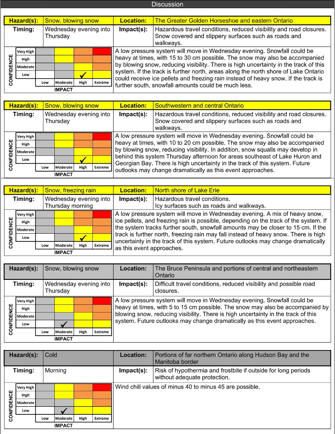
Details: A low-pressure system will move in Wednesday evening. Snowfall could be heavy at times, with 15 to 30 cm possible. Blowing snow may reduce visibility. If the system tracks further north, areas along the north shore of Lake Ontario could see ice pellets and freezing rain instead of heavy snow. If it tracks south, snowfall amounts may be lower.
Southwestern and Central Ontario
Hazard(s): Snow, blowing snow
Timing: Wednesday evening into Thursday
Impact(s): Hazardous travel conditions, reduced visibility, road closures, snow-covered and slippery surfaces.
Confidence: Low
Impact: High
Details: A low-pressure system will bring snowfall of 10 to 20 cm, with potential blowing snow reducing visibility. Snow squalls may develop behind the system Thursday afternoon, especially southeast of Lake Huron and Georgian Bay. Track uncertainty remains high, and outlooks may change significantly.
North Shore of Lake Erie
Hazard(s): Snow, freezing rain
Timing: Wednesday evening into Thursday morning
Impact(s): Hazardous travel conditions, icy surfaces on roads and walkways.
Confidence: Low
Impact: High
Details: A mix of heavy snow, ice pellets, and freezing rain is possible, depending on the storm’s track. A more southern track may bring up to 15 cm of snow, while a northern track could result in more freezing rain. Forecast confidence is low, and updates will be necessary.
Bruce Peninsula and Portions of Central & Northeastern Ontario
Hazard(s): Snow, blowing snow
Timing: Wednesday evening into Thursday
Impact(s): Difficult travel conditions, reduced visibility, possible road closures.
Confidence: Low
Impact: Moderate
Details: A low-pressure system will bring snowfall of 5 to 15 cm, with blowing snow reducing visibility. Track uncertainty remains high, and outlooks may change significantly.
Far Northern Ontario (Along Hudson Bay & Manitoba Border)
Hazard(s): Extreme cold
Timing: Wednesday morning
Impact(s): Risk of hypothermia and frostbite if outside for prolonged periods without adequate protection.
Confidence: Low
Impact: Moderate
Details: Wind chill values of -40 to -45 are possible, creating dangerous conditions for exposed skin. Proper winter gear is essential.
While quite a bit of uncertainty remains regarding the exact intensity and placement of snowfall, wind gusts, and freezing rain, confidence continues to increase that parts of Ontario will experience yet another high-impact winter event. Those with travel plans should closely monitor for updates as this develops.
We’ll continue to provide updates as more details become available. Stay safe and stay prepared!
Disclaimer: These forecasts are issued by Environment Canada and typically published via their Twitter/X accounts. We receive these forecast via a daily email and often publish them for our communities to see.


