Nocturnal Thunderstorm Threat With Damaging Wind Gusts and Isolated Tornado Risk for Southwestern Ontario Tonight
/

updated map - 10:50 PM (CLICK HERE FOR THE PREVIOUS MAP)
NOTE: YOU CAN CLICK ON THE MAP TO OPEN A ZOOMABLE IMAGE
UPDATE (10:50 PM):
We’ve been closely tracking the line of storms developing across Michigan, and it’s now set to move into Deep Southwestern Ontario over the next few hours.
Based on the latest model data, current environmental conditions, and how well the storm is holding together despite the lack of daylight heating, we believe there’s enough evidence to upgrade parts of Deep Southwestern Ontario to a ‘strong’ (3/5) risk—mainly due to the potential for intense wind gusts.
Large hail up to the size of toonies is also possible, and we can’t completely rule out an isolated tornado.
We’ve also extended the ‘slight’ (2/5) risk further inland to include areas like Goderich and London, as new data suggests the line could stay fairly strong as it tracks deeper into Southwestern Ontario during the pre-dawn hours. Again, damaging wind gusts remain the primary threat.
The line is expected to cross the border just after midnight, with the severe threat gradually tapering off but still continuing until around 3–4 AM.
ORIGINAL FORECAST
While storm season has had a quiet start in Southern Ontario, things are beginning to ramp up with a late-night storm risk expected between Thursday evening and early Friday morning. A strong line of storms is forecast to form across Michigan late tonight, initially beginning as discrete supercells over parts of Wisconsin and Illinois.
Based on the latest guidance, these storms are expected to organize into a more linear structure as they track eastward, eventually crossing into Southwestern Ontario sometime just after midnight. While they’ll likely lose some of their strength after dark, especially without daytime heating, the atmosphere may still be supportive enough for them to maintain some intensity as they move into our region.
That said, there’s still a fair amount of uncertainty about just how strong this line will be once it crosses the border, and how quickly it might weaken as it tracks northeast through the early morning hours of Friday.
The biggest concern with this system is the potential for damaging wind gusts. This squall line will stretch from the Upper Peninsula of Michigan all the way down through Ohio as it enters Ontario, which could lead to widespread impacts. Areas from the Bruce Peninsula all the way down to Deep Southwestern Ontario are at risk of strong winds embedded within the line.
The highest risk appears to be in Deep Southwestern Ontario, where the line will first cross into Ontario. Regions like Windsor, Leamington, Chatham, and Sarnia are most likely to experience the strongest part of this line. While damaging wind gusts are the main hazard, we also can’t completely rule out the chance for hail and even a brief tornado, especially if the storms arrive a bit earlier than forecast.
Hail up to the size of quarters is possible, and while the tornado risk is considered low overall, it does exist. The biggest concern here is that this is a nocturnal threat. If a tornado were to develop overnight, it would be harder to spot and could be rain-wrapped, making it even more dangerous. That’s why it’s so important to stay alert and have a way to receive warnings while you sleep.
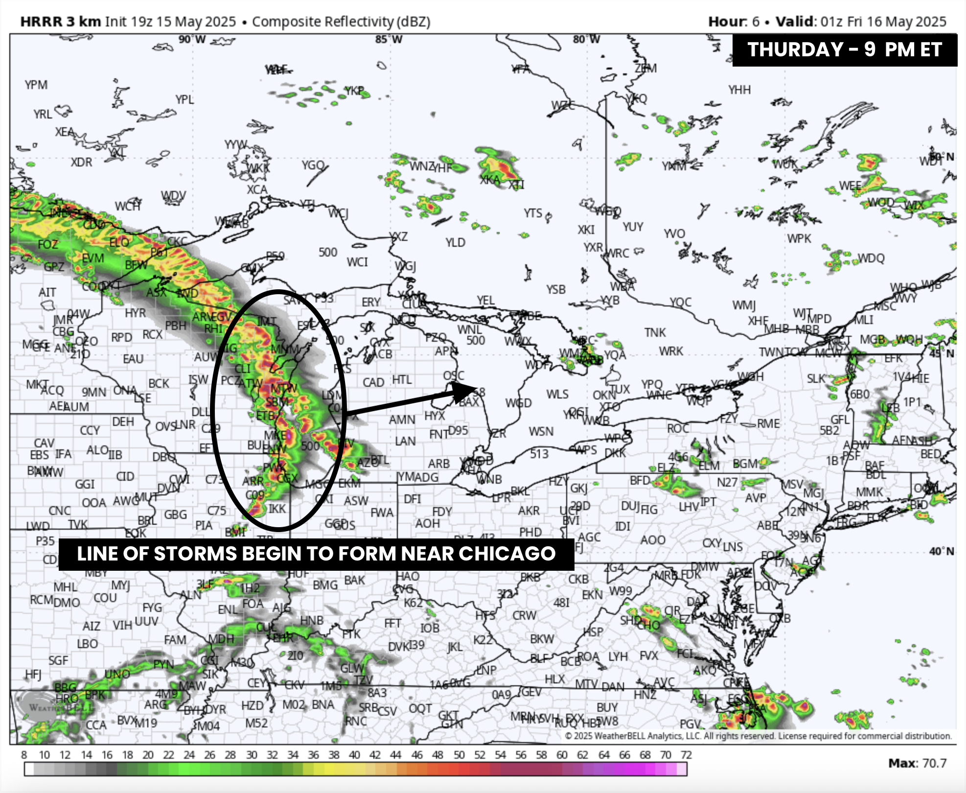
SIMULATED RADAR - MAP FROM WEATHERBELL

Storm development will begin with discrete cells over Wisconsin and Illinois, likely forming into a long line around 8–10 PM near Chicago and across Lake Michigan.
The timing of this formation is crucial. If the line develops sooner and sweeps across Michigan quickly, it could result in a more robust severe risk for Deep Southwestern Ontario, where the environment is more favourable before midnight.
No matter the timing, damaging winds remain the most likely outcome with this type of linear storm setup.

SIMULATED RADAR - MAP FROM WEATHERBELL
As of now, future radar models suggest the storms will cross into Ontario between 1 and 2 AM, hitting areas like Windsor and Sarnia first before stretching further northeast. However, there’s still wiggle room in this timing. It could arrive earlier and stronger, or later and already weakening before reaching our region.

ESTIMATED TORNADO ENVIRONMENT - MAP FROM WEATHERBELL
While widespread wind damage is the primary concern tonight, there is some minor tornado potential—especially in Essex County just after midnight. Again, the odds are low, but not zero.
Because of the overnight timing, it's extra important to have notifications enabled on your phone or weather radio. Make sure you have a way to receive alerts while you're asleep in case a warning is issued. Our free app is a great way to instantly get Environment Canada alerts, along with our custom notifications issued for your exact location.

SIMULATED RADAR - MAP FROM WEATHERBELL
The line of storms is expected to continue northeast through the early morning hours, bringing heavy rain, gusty winds, and frequent lightning to much of Southwestern Ontario and parts of the Greater Toronto Area between 3 and 6 AM.
While the line should gradually weaken during this time, it could still pack a punch in some localized areas. There’s some uncertainty around how long it will be able to hold its strength since the atmospheric environment in Ontario is notably weaker than what the storms had access to in the U.S.
Latest model runs show the system likely fizzles out once it reaches Lake Simcoe, meaning Eastern and Central Ontario probably won’t see much beyond a few scattered morning showers or storms.
Another round of storms is possible Friday afternoon and evening, particularly for Eastern Ontario and parts of Deep Southwestern Ontario. We’ll have more details on that in a separate update.

As it stands, the highest storm risk tonight is in Deep Southwestern Ontario, where we currently have a slight risk (2/5) for severe weather. The main hazard is damaging wind gusts between 12 and 6 AM, though isolated tornadoes and hail up to the size of quarters are also possible.


For the rest of Southwestern Ontario and the Golden Horseshoe, the risk is lower—a marginal (1/5) severe threat—with isolated pockets of wind damage being the most likely outcome. There’s also a very low tornado risk along the Lake Huron shoreline as the line initially pushes into the region. Hail up to the size of nickels could accompany some of these storms.
In addition to the overnight threat, a few isolated pop-up storms are possible during the late afternoon and early evening across parts of Grey-Bruce. While these are not expected to be severe, funnel clouds are possible, including a low-end risk of a landspout tornado. See our custom notification for more on the funnel cloud setup.
Stay weather-aware tonight. Keep your devices charged, notifications turned on, and have a plan in place just in case you need to take shelter quickly. We’ll continue to monitor the latest data and provide updates as the situation evolves, including a possible live stream later tonight.

