Severe Storms Target Southwestern Ontario Wednesday with Tornado and Damaging Wind Risk
/

NOTE: YOU CAN CLICK ON THE MAP TO OPEN A ZOOMABLE IMAGE
Storm season has certainly gotten off to a slow start in Southern Ontario, to say the least. Aside from a few scattered events earlier in the spring, it’s been a fairly quiet lead-up to summer across the region.
However, that’s about to change in a big way. As we approach the summer solstice on Friday, which marks the official start of summer, the pattern is shifting. Warmer temperatures and a more active storm pattern are setting the stage for what looks like a much stormier stretch of weather.
Wednesday’s setup will feature an environment that becomes increasingly favourable for storm development through the day. The main focus will be across Southwestern Ontario and into parts of the Golden Horseshoe during the afternoon and evening hours.
While the storms will likely start off isolated and scattered, they are likely to move quite slowly. This raises the potential for localized flooding, especially in areas that see multiple rounds of heavy rainfall from training storms.
A few storms could also produce near-severe wind gusts and small hail, particularly during the late afternoon and early evening. While not every area will be affected, those that are could see some very heavy rainfall over a short period of time.
The greater concern comes later in the day for Deep Southwestern Ontario, where a more potent setup could take shape.
Storms are expected to develop over Michigan during the afternoon and early evening. As these storms intensify, they may track eastward and cross into Ontario during the evening. Areas such as Windsor, Chatham, and Sarnia could be in the path of these stronger cells.
These storms will be moving into a more unstable environment that could support damaging wind gusts, quarter-sized hail, and potentially even an isolated tornado.
While confidence in storm development across the border is high, the extent of the severe threat in Ontario will depend heavily on the exact timing of when those storms cross into the province.

ESTIMATED AIR TEMPERATURE - MAP FROM WEATHERBELL
Before the storms arrive, temperatures will be on the rise across much of Southern Ontario. Afternoon highs are expected to reach the mid to upper 20s across Southwestern Ontario and into the Golden Horseshoe by early afternoon.
Central and Eastern Ontario will be a bit cooler, with highs ranging from the low to mid-20s. The Ottawa Valley could end up a touch warmer than the surrounding areas.

SIMULATED RADAR - MAP FROM WEATHERBELL
This heat and humidity will act as fuel for thunderstorm development, especially around Lake Huron and into areas near Lake Simcoe by the afternoon. Models vary on how widespread storm activity will be, with some showing scattered pop-up storms and others hinting at a more organized cluster.
Either way, any storms that do develop will be slow-moving, and locations underneath these cells could see multiple rounds of rainfall. That’s where the flood threat becomes more concerning, especially in urban areas that are more prone to flash flooding.
For much of the region, flooding will remain the primary concern. However, a few stronger storms could bring near-severe wind gusts and hail up to nickel size.

SIMULATED RADAR - MAP FROM WEATHERBELL
By the evening, our attention will turn stateside, where strong to severe storms are expected to organize over Michigan.
These storms are forecast to cross into Deep Southwestern Ontario sometime during the evening. The atmospheric setup in that region will support damaging wind gusts, hail up to the size of quarters, and the potential for a tornado.
Again, the timing will be critical. If these storms arrive before sunset, they’ll have access to better instability and surface heating, making them more capable of becoming severe. However, if they hold off until later in the night, the lack of daylight heating could limit their intensity.

ESTIMATED ENVIRONMENT FOR TORNADOES - MAP FROM WEATHERBELL
Models are currently showing a narrow window between 6 and 9 PM where the tornado potential could materialize, particularly around Windsor, Leamington, and Chatham. This will depend on how quickly storms move eastward from Michigan and whether they interact with the more favourable environment before it begins to weaken.
Once the sun sets, the tornado threat should diminish quickly, though some thunderstorm activity may continue through the night into early Thursday morning.
While a few non-severe thunderstorms may linger overnight, the severe threat will likely taper off before midnight.


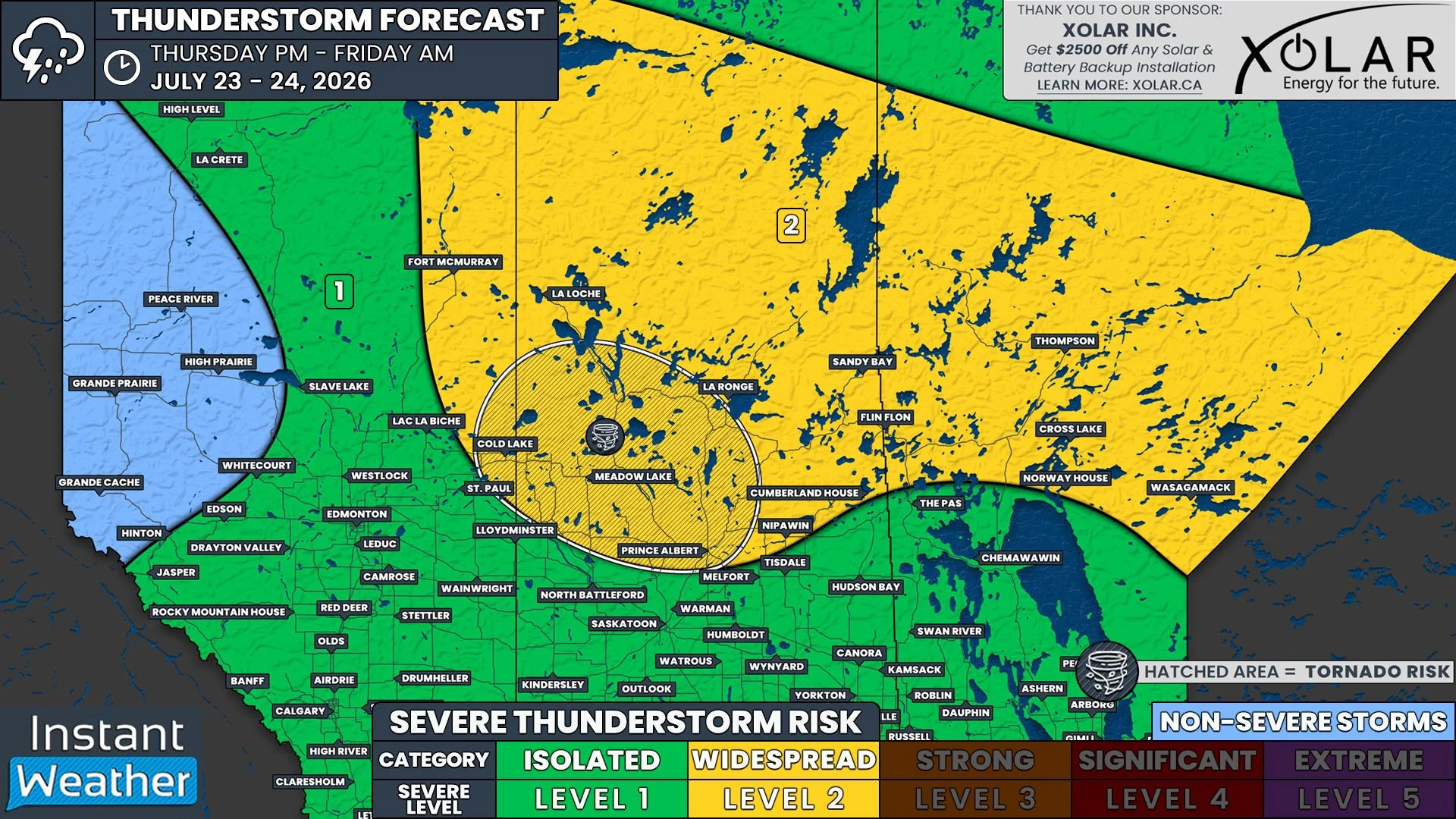
As it stands, the highest risk for severe weather on Wednesday will be focused on Deep Southwestern Ontario, including Windsor, Leamington, Chatham, and Sarnia, with the window for impactful storms likely between 3 PM and midnight.
We’ve placed this region under a Level 2 (Widespread) risk due to the potential for damaging wind gusts and one or two tornadoes. Up to quarter-sized hail and locally up ot 50-100mm of rain is also possible.


Elsewhere across Southwestern Ontario and into the Golden Horseshoe, we’ve gone with a Level 1 (Isolated) risk.
This lower tier is mainly for flooding concerns, as slow-moving storms could drop significant rainfall over the same areas during the afternoon and early evening.
Some locations could also see isolated severe wind gusts, nickel-sized hail, and a very low tornado risk (confined mainly to parts of Southwestern Ontario).