Ottawa Area, Eastern Ontario in Bullseye for Thursday’s Widespread Severe Storm & Tornado Risk; Isolated AM Risk for Southwestern Ontario & GTHA
/

NOTE: YOU CAN CLICK ON THE MAP TO OPEN A ZOOMABLE IMAGE
The oppressive heat that has been locked across Southern Ontario the past week is on the way out. But first that relief will come in the form of a cold front that is likely to clash with the hot air to create some strong thunderstorms ahead of the front.
Some of these storms, particularly in Eastern Ontario during the afternoon on Thursday could reach severe levels with strong wind gusts being the main threat. One or two tornadoes are also possible with the strongest environment being along a corridor from Tweed to Ottawa.
With the cold front already on our doorstep as of early Thursday morning, it is expected to gradually slide across Southwestern Ontario and the Golden Horseshoe through the overnight and pre-dawn hours on Thursday.
While this isn’t ideal timing for storm development, we can’t rule out some nocturnal development. And if these developments occur, the environment could certainly support a few marginally severe storms primarily with strong wind gusts and heavy rainfall.
The tornado risk isn’t zero, but it’s also not particularly strong due to the timing of the overnight storms. But the environment could support a brief spin-up through Southwestern Ontario into the GTA, but it’s very questionable.
STAY AHEAD OF THE STORM
Join us on YouTube as we track any storms that develop throughout the day on Thursday

For Deep Southwestern Ontario, we are looking at the bulk of the risk between midnight and 6am with non-severe storms potentially continuing until 9am. These storms could bring isolated damaging wind gusts, nickel-sized hail and 50-100mm of rain.
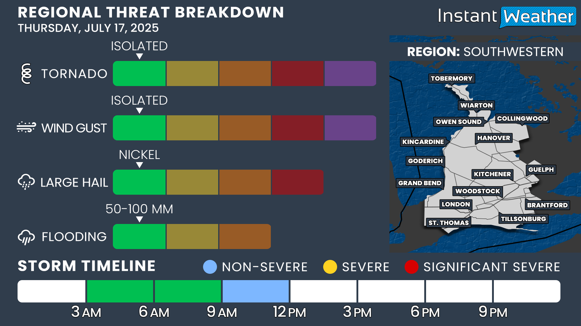
In Southwestern Ontario, the risk follows a similar overnight pattern as Deep Southwest, though it’s slightly more delayed. The environment will still support some isolated strong wind gusts and localized flooding, but again, the timing works against widespread severe development. The threat of large hail and a brief tornado is low, but not zero. The risk should ease by the time we hit the late morning hours.

For the Golden Horseshoe, storms are expected to roll through in the mid-to-late morning hours, primarily between 6:00 a.m. and 12:00 p.m. Similar to the regions farther west, the overnight timing limits storm strength, but a few marginally severe cells are possible.
Gusty winds, heavy downpours and nickel-sized hail are the main concerns. The tornado risk is quite low, though not completely off the table. Things should quiet down quickly as we head into the early afternoon

In Central Ontario, storms may get going a bit earlier compared to the GTA, potentially arriving in the pre-dawn hours and continuing through the morning.
The main threat here also leans toward damaging wind gusts and flooding, especially if storms repeatedly track over the same areas. Nickel-sized hail is possible, and while the tornado risk is low, it’s not zero. Timing should help reduce the severity, but there’s still a window for a few stronger cells.

Eastern Ontario is where the severe threat becomes much more notable. As the front progresses into a more unstable environment in the afternoon, the potential for strong storms ramps up.
Damaging wind gusts appear to be the most likely hazard, but one or two tornadoes are also possible, particularly along a corridor from Tweed to Ottawa, where models show the strongest instability and tornado environment overlapping.
Hail around quarter-size and localized flooding are also concerns with any stronger storms that develop.

Southeastern Ontario will also be in the bullseye for strong to severe storms, particularly from late afternoon into the early evening. Kingston through Brockville and into Cornwall sits right along the corridor of stronger wind potential.
Wind gusts may reach damaging levels, with a few storms capable of producing quarter-sized hail. Flooding is also possible in areas that get hit by repeated rounds.
While the tornado risk isn’t as pronounced as the Ottawa Valley, it’s still something we’ll be watching closely.
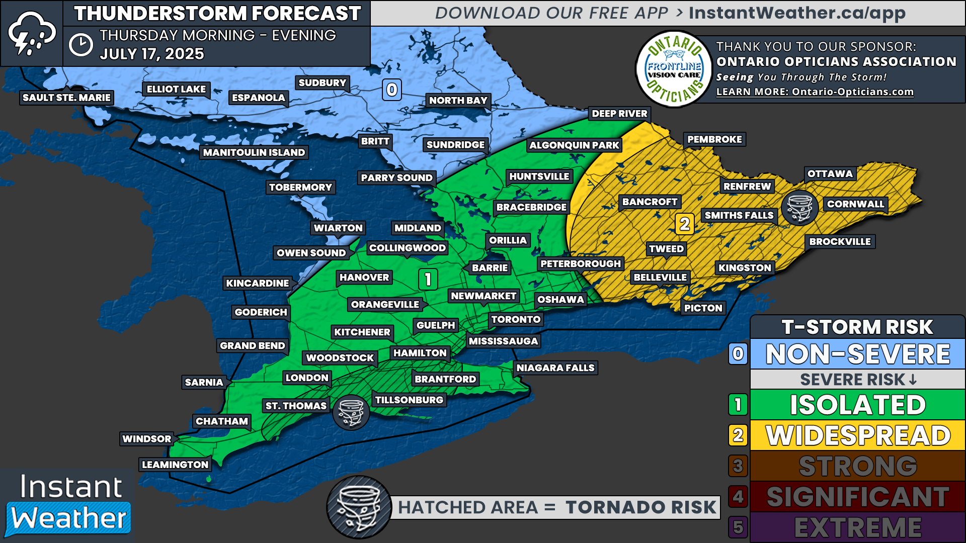

For our updated map, it’s largely unchanged from our preliminary forecast. The main changes we made was shrinking the ‘widespread’ risk zone to cover Eastern Ontario only. The latest data suggests that the Niagara region is less likely to see storms so the support for a widespread risk is no longer there.
We have also extended the isolated risk into the rest of Southwestern Ontario to cover the very questionable severe risk during the overnight and early morning hours.
For the tornado risk, while there is a non-zero risk for a tornado across all parts of the severe risk, we have focused it on the Ottawa Valley. This is where the latest model data continues to show the strongest tornado risk. Mainly during the mid to late afternoon hours.
There is also a more heightened tornado risk along the London to Hamilton corridor during the morning hours. While the risk isn’t super strong, this is where we believe a tornado is most likely to occur if one does occur in the morning.
The storm risk should taper off around the dinner hour as storms move out into Quebec and Upstate New York.


