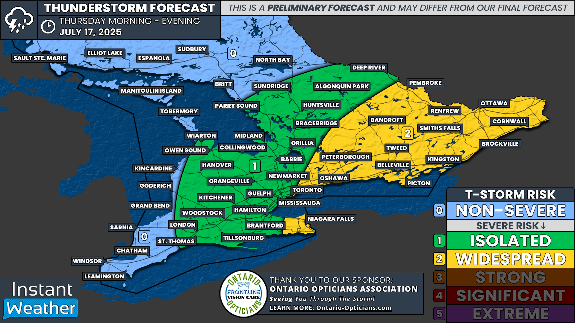
Heat Wave Ends With a Bang: Widespread Severe Thunderstorm Threat for Southern Ontario on Thursday
/
NOTE: YOU CAN CLICK ON THE MAP TO OPEN A ZOOMABLE IMAGE
As Southern Ontario continues to deal with a prolonged heat wave, there is some relief on the way. A cold front is expected to sweep through the region on Thursday, bringing temperatures back down to near-seasonal levels. But unfortunately, that relief won’t come quietly.
We’re closely watching Thursday for the potential of severe weather across much of Southern Ontario.
Thunderstorms are expected to fire up along the cold front as it moves through the province, with the potential for widespread severe storms especially across Eastern Ontario, Central Ontario and possibly parts of the Greater Toronto Area (GTA) during the morning and afternoon.
These storms may pack a punch, bringing strong wind gusts, large hail, heavy rain and possibly even an isolated tornado. The best chance for any rotating storms (and tornadoes) will be in Eastern Ontario later in the day when the environment becomes more favourable for storm organization.
With more high-resolution models coming into range, we’re getting a better handle on how things may play out. Based on this data, we’ve put together a preliminary forecast map showing where the greatest risk for severe weather currently appears to be.
That said, this event is still just under 48 hours away, and plenty could still change. The timing, placement and severity of storms may shift, so expect updates over the next couple of days. We’ll be keeping a close eye on the data and will continue to post updates as things evolve.
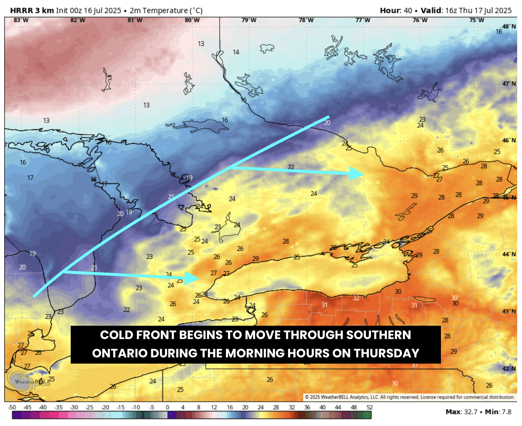
ESTIMATED TEMPERATURE in °C - MAP FROM WEATHERBELL
At this point, it looks like the cold front will reach the western parts of Southern Ontario sometime during the morning hours. The strongest environment for severe weather will be just ahead of the front. But because of the early timing, the threat for severe storms in Southwestern Ontario and along the Lake Huron shoreline looks more limited.
Still, the setup could be just strong enough to trigger a few marginally severe storms by late morning or early afternoon as activity moves into Central Ontario and the Golden Horseshoe.

SIMULATED RADAR - MAP FROM WEATHERBELL
As the cold front continues eastward into the afternoon, this is when we expect storm activity to really ramp up. With daytime heating providing an extra energy boost, we’re watching the Peterborough to Bancroft corridor around noon, with storms potentially reaching Kingston and the Ottawa Valley by early to mid-afternoon.
Storms are expected to move out of Ontario and cross into New York and Quebec around the dinner hour. However, this is subject to change depending on the timing of the cold front.
NOTE: YOU CAN CLICK ON THE MAP TO OPEN A ZOOMABLE IMAGE

Given the setup, we’ve gone with a ‘widespread’ (level 2 out of 5) severe risk for much of Eastern Ontario. This includes the potential for several severe thunderstorms capable of producing damaging wind gusts, hail and heavy rainfall.
We’ve also extended this risk into parts of the Niagara region where some models are hinting at rapid storm development during the early afternoon before storms cross the border.
The rest of Southern Ontario, excluding Deep Southwestern Ontario and the Lake Huron shoreline, falls under an ‘isolated’ (level 1 out of 5) severe risk. Most storms in these areas will likely stay below severe limits, but a few could briefly become marginally severe during the morning or early afternoon.
Currently, Deep Southwestern Ontario and Northeastern Ontario are not in the risk zone for severe weather on Thursday. That’s due to the early arrival of the cold front which will likely move through these areas before storms have a chance to fully develop. That could change should the cold front arrive later in the day when the environment is strongest.
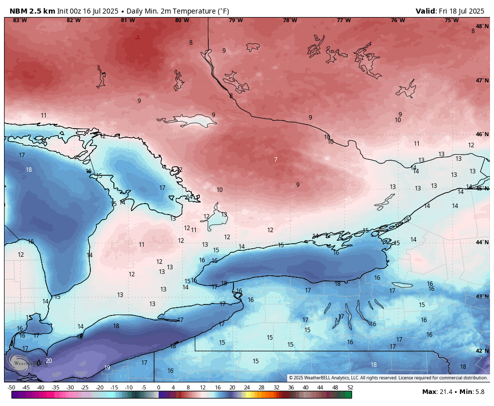
ESTIMATED Morning LOW in °C - MAP FROM WEATHERBELL
In the wake of the cold front, temperatures will drop significantly Thursday night into Friday morning. Some higher elevation areas in Central Ontario could wake up to morning lows in the upper single digits!
Most of Southern Ontario will see lows in the low to mid teens, which will be a welcome change after several nights of muggy 20°C+ lows.
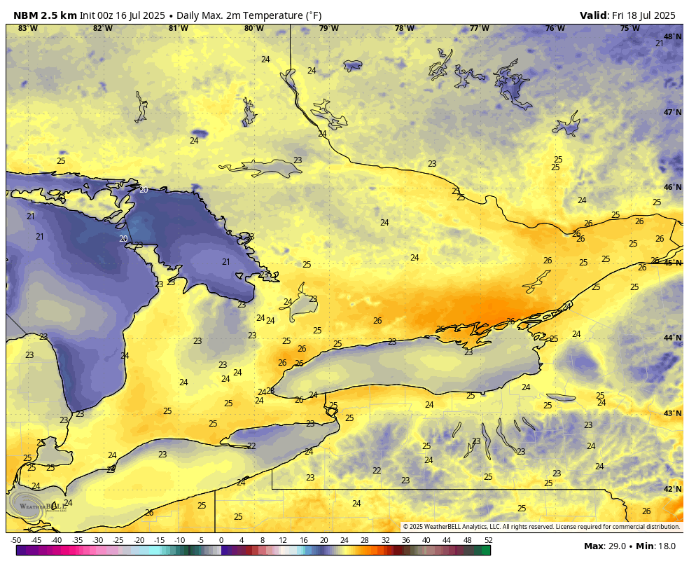
ESTIMATED DAYTIME HIGH in °C - MAP FROM WEATHERBELL
Daytime highs on Friday will also cool back to near-seasonal values, with most of the region seeing mid-20s. But enjoy it while it lasts. A gradual warm-up is expected over the weekend with temperatures climbing back into the upper 20s and even low 30s by early next week.


