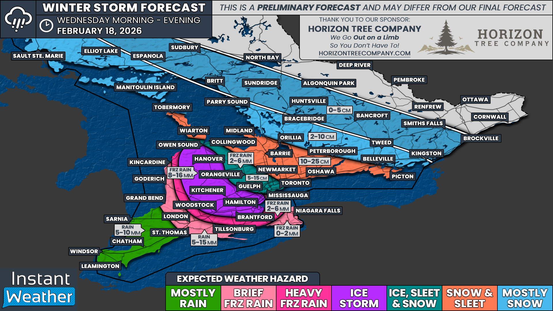
Significant Winter Storm for Toronto, Hamilton, Barrie, Kitchener & Peterborough Area on Wednesday Threatens Travel and Power Outages
/
NOTE: YOU CAN CLICK ON THE MAP TO OPEN A ZOOMABLE IMAGE

A mid-week winter storm is on the horizon for Southern Ontario and threatens to bring a buffet of winter weather hazards starting Wednesday morning. This system will feature everything from a potential ice storm risk, raising the threat of widespread and prolonged power outages, to a quick blast of heavy snow with accumulations of up to 25 cm in some areas.
Significant impact on travel is likely, with the worst conditions expected to occur at the height of the morning rush hours across the Greater Toronto Area, Barrie, Kitchener and Hamilton. Roads could become very icy, snow covered, and hazardous in a relatively short period of time, especially where freezing rain and ice pellets are involved.
Widespread school bus cancellations are likely on Wednesday for many boards within the hardest hit regions. Even if your exact area misses the worst of the ice or snow, nearby regions could still see severe conditions that impact school buses.
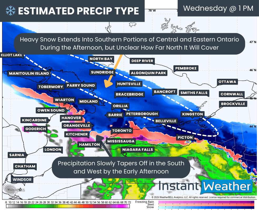
PRECIP TYPE - MAP FROM WEATHERBELL
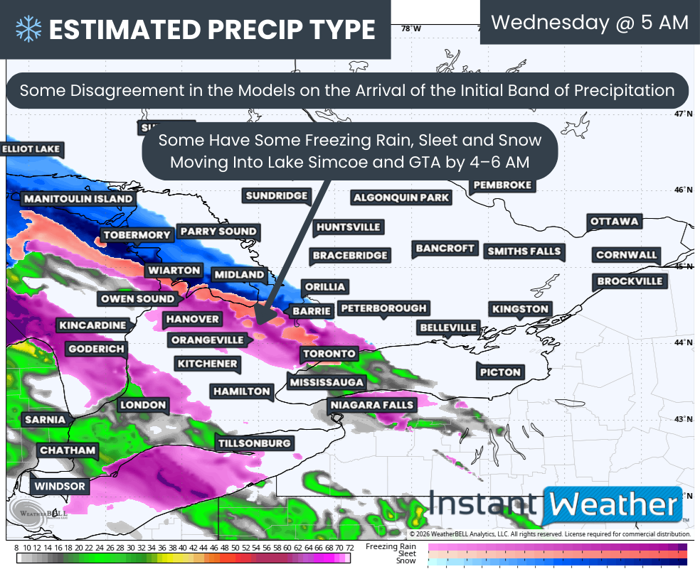
While we are now less than 48 hours from the expected start of this winter storm, there are still several forms of divergence in the different weather models. That disagreement even extends to when the impacts are forecast to begin on Wednesday morning, which is a key detail for both the morning commute and school operations.
The HRRR (American) model shows a leading band of precipitation moving into areas from Grey Bruce through Lake Simcoe and into the Greater Toronto Area as early as 4 to 6 AM on Wednesday. This would be a very early start and would catch many people just as they are waking up and preparing to head out the door.
Temperatures are generally expected to be several degrees below freezing at the surface, with above-freezing temperatures aloft in the upper air. This setup allows for freezing rain to be the likely predominant precipitation type in that first band.
If that scenario does occur, it could lead to icy conditions developing quickly just in time for the morning commute and almost certainly mean school bus cancellations in many of these areas. Even a thin glaze of ice can be enough to cause vehicles to lose traction and make sidewalks and driveways extremely slippery.
That warm air aloft is likely to hit a wall somewhere around a line from Orillia to Kingston. Any precipitation that falls north of this approximate boundary will likely come down mainly in the form of snow instead of freezing rain, which will create a sharp transition zone over a relatively short distance.
Other models, however, do not show this first leading band of precipitation. Instead, they delay the onset of the weather until the arrival of the main precipitation band pushing in through Southwestern Ontario during the mid to late morning hours. This difference in timing and structure is one of the main reasons there is still some uncertainty in how the day will unfold.
PRECIP TYPE - MAP FROM WEATHERBELL
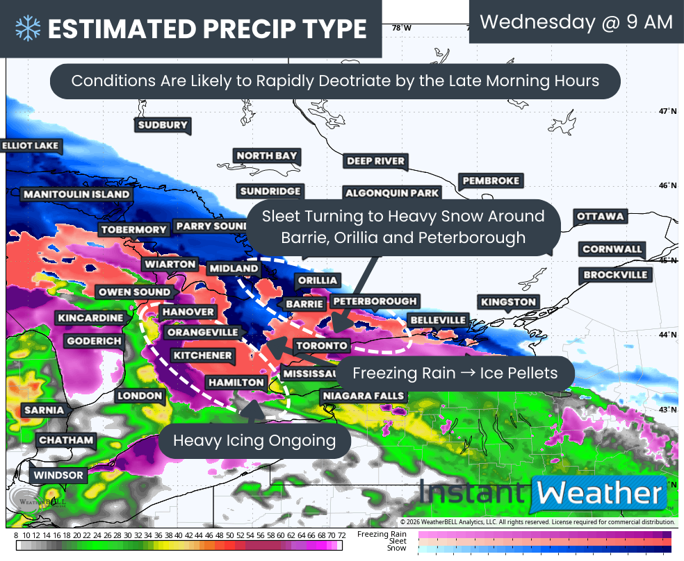
By the mid-morning hours, a band of sleet and ice pellets is expected to extend from Barrie and Orillia through Peterborough and into Belleville.
This band of mixed precipitation is likely to gradually transition to heavy snow by the late morning or early afternoon as colder air in the upper levels is able to push further south. Once that colder air fully penetrates the upper levels, snowfall rates could increase quickly with less ice pellets mixed in.
There is some uncertainty on how long the warmer air aloft can hold on, and this will have a direct impact on the overall snowfall totals. The longer it can persist, the more ice pellets there will be, which tends to suppress the amount of precipitation that falls as fluffy, accumulating snow.
The battle zone is expected to be centered around a corridor from the Bruce Peninsula through the Dundalk Highlands and south into Peel and York Region along with the City of Toronto. In this corridor, we are expecting a few hours of freezing rain which will then transition to ice pellets sometime in the mid to late morning.
Again, there is some disagreement in the models on the temperature dynamics and the exact timing of when the ice pellets will start to mix in. The faster the switch over to ice pellets, the less pure icing that will be able to occur, which would slightly reduce the risk of serious ice buildup but still maintain hazardous travel.
Further to the south and west, an area of very heavy freezing rain is expected to persist throughout much of the late morning hours and continue into the afternoon. This zone includes Hamilton through Kitchener and into portions of Perth, Wellington, Grey and Bruce counties.
Significant icing is expected here, with accretion rapidly occurring on untreated roads, sidewalks, tree branches and power lines. The combination of a cold surface, steady freezing rain and heavier precipitation rates will allow ice to build up quickly and efficiently.
Regular rain is expected for Deep Southwestern Ontario, including Windsor, Chatham, Sarnia into London, the Lake Huron shoreline and into the Niagara region. In these areas, the surface warm-up should be substantial enough to avoid a prolonged freezing rain event.
Some brief freezing rain is possible for London and the Niagara region during the mid to late morning, but it should transition to regular rain after an hour or two as temperatures rise above the freezing mark at the surface. Even so, that short window could still lead to some localized slick spots before the changeover.
WIND GUSTS - MAP FROM WEATHERBELL
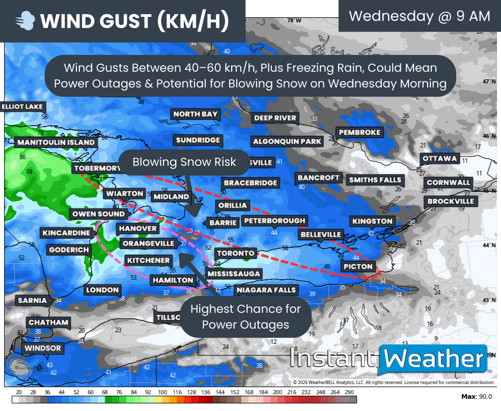
Another factor at play that will enhance the impact of this winter storm is the development of stronger wind gusts through the mid to late morning on Wednesday. These winds will overlap in both time and space with the heaviest precipitation for many areas.
Current data suggests the wind gusts could reach 40 to 60 km/h in the same regions that are seeing heavy precipitation from the winter storm. This combination of wind and wintry precipitation is what elevates the risk of more serious and prolonged impacts.
For those getting ice pellets and snow, the primary impact from the wind will be reduced visibility from blowing snow from the Bruce Peninsula through Simcoe County, Peterborough and Belleville. Localized whiteout conditions will be possible at times, especially in more open and rural stretches of highway.
More significantly though, this wind may combine with the heavy icing from the freezing rain. The ice load on power lines and tree branches will make them more susceptible to being blown down by the stronger wind gusts.
That increases the likelihood of power outages from Hamilton through Kitchener, Guelph and into the Hanover and Owen Sound area. In some cases, outages could last many hours or even longer if damage to infrastructure is widespread and crews have difficulty accessing affected areas due to road conditions.
PRECIP TYPE - MAP FROM WEATHERBELL
Poor conditions will continue past noon into the early afternoon with a band of steady heavy snow stretching from Simcoe County through Peterborough and into Kingston. Travel in this corridor could be especially difficult as snowfall accumulates on top of any earlier ice or slush.
The leading edge of this band of snow is a little unclear, as some models have it continuing to expand northward into Central and Eastern Ontario. In that scenario, a swath of heavy snow could extend from Sudbury down into Muskoka and through Bancroft.
Other models keep the snow more localized to the corridor from Barrie through Peterborough and into Kingston. This difference will play a big role in determining which communities end up closer to the higher end of snowfall totals.
Patchy freezing rain and ice pellets will also continue across the Golden Horseshoe, although this is expected to gradually clear out during the first few hours of the afternoon. The precipitation type may still flip back and forth for a time as the temperature profile continues to evolve.
This may switch over to heavy snow, especially around Toronto, York and Durham Region by the early afternoon. That could bring a quick blast of heavy snow on top of the earlier icing and several hours of ice pellets, which would be enough to worsen road conditions again significantly.
This snow is expected to clear out by the late afternoon as it slowly breaks apart while moving deeper into Eastern Ontario. Conditions will gradually improve from west to east, but roads could remain messy into the evening even after the snow has ended.
Ottawa and areas around the Quebec border may see some light snow during the afternoon as this system continues to break apart. However, accumulation here should generally stay under 5 cm, which is on the lower side compared to areas further south and west.
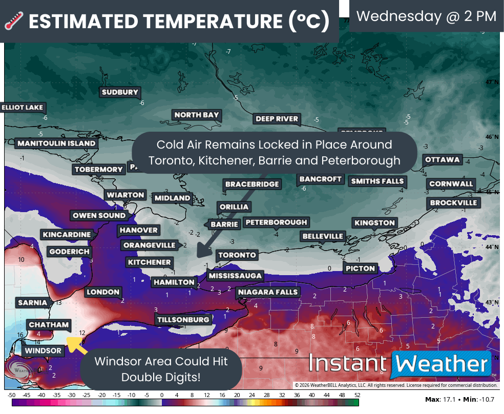
ESTIMATED TEMP - MAP FROM WEATHERBELL
This winter storm will also create quite a temperature contrast across Southern Ontario. While Central and Eastern Ontario, extending into areas around Lake Simcoe, the Dundalk Highlands, Kitchener and the GTA, will be firmly below freezing throughout the duration of this system, other regions will have a completely different experience.
The same cannot be said for Deep Southwestern Ontario, which is likely to see very warm air move in through the morning and early afternoon. This will send temperatures to levels not seen since before the start of winter, creating a sharp dividing line across the province.
Some models have the Windsor, Chatham and Sarnia area pushing into the double digits. In the case of Windsor, some show a daytime high around 15 degrees at 2 PM, which is remarkably warm for a day when other parts of the province are dealing with a winter storm.
Instead of a winter storm, it will feel like an early taste of spring across Deep Southwestern Ontario. Rain and mild temperatures there will stand in stark contrast to the icy, snowy conditions unfolding just a few hours’ drive to the northeast.
London, the Lake Huron shoreline, and the Niagara region are expected to hover in the low to mid single digits. That will be just warm enough to stay mostly outside of the worst wintry precipitation, but nowhere near as warm as those further southwest.

NOTE: YOU CAN CLICK ON THE MAP TO OPEN A ZOOMABLE IMAGE

It is important to note that this system brings a very tricky forecast because if models are off by even a fraction of a degree, it could significantly alter the mix of precipitation that an area sees. A subtle shift in the placement of the warm layer could either increase or decrease the overall impact dramatically.
As we have covered throughout the forecast, multiple areas of uncertainty remain, which should hopefully be cleared up by the time of our final forecast. Updated model data will help us refine the timing, precipitation types and amounts.
But with this being our preliminary forecast, we have initially gone with wider ranges on the forecast precipitation totals to cover the different scenarios. This is the most responsible approach when the atmosphere is finely balanced between different outcomes.
We expect to narrow these ranges in our final forecast as we gain better confidence in what will unfold. While significant changes to the overall setup are unlikely, we could see some shifts, with some areas jumping one category in either direction, especially if you are located right near the edge of one of the forecast zones.
Current indications suggest that the focus of the most significant impacts from this winter storm is likely to exist in a zone that encompasses Hamilton, Brantford, Burlington, Oakville, Cambridge, Guelph, Kitchener, Stratford, Woodstock, Mitchell, Listowel, Fergus, Arthur, Minto, Mildmay, Hanover, Chatsworth and Owen Sound. This is the area that currently has the highest risk for serious icing.
The predominant precipitation type throughout this event in that corridor is expected to be freezing rain, which may be quite heavy at times through the late morning and early afternoon. Periods of lighter freezing drizzle could fill in the gaps between heavier bursts.
This may reach ice storm levels, with the risk of widespread power outages through the hardest hit areas as the steady icing combined with strong wind gusts brings down tree branches and power lines. Travel may become dangerous or even impossible along some rural routes.
Ice accretion of 8 to 16 mm is possible here, and localized spots could see even higher amounts if heavier bands linger longer than expected. That much ice is more than enough to cause tree damage and infrastructure issues.
Another concerning aspect of this event is that much of this area is not expected to have a meaningful warm-up after the icing occurs. In fact, it is likely to remain below freezing through Thursday and into Friday.
That means impacts could persist for several days, as the ice will remain locked in place on surfaces, making cleanup and restoration efforts more challenging. Sidewalks, driveways and untreated back roads could remain treacherous well after the storm itself has moved on.
Further to the south and west, lower freezing rain accretion is expected as a transition to regular rain is expected for areas like the Niagara region through London and east of Lake Huron later in the morning. Here, temperatures rising above freezing will help limit ice buildup.
To the north and east of the main ice storm zone, we are expecting a zone including Dufferin County, along with Brampton, Vaughan, Mississauga and Toronto, to see a mix of all three wintry precipitation types. This is where the forecast becomes especially complex.
This will start with a few hours of freezing rain in the mid to late morning hours, amounting to up to 2 to 6 mm of ice accretion. Even on the lower end of that range, sidewalks and untreated surfaces will become slick.
By the late morning, this zone is expected to switch to ice pellets and then finally to heavy snow by the early afternoon. This changeover sequence will play a major role in how much snow is able to accumulate.
We have a large snowfall range here, with 5 cm on the low end and 15 cm on the upper end. This is due to the uncertainty around how long the ice pellets will last before switching over to snow.
If the switch over to snow happens faster than expected, this area could get closer to 15 cm of accumulation. A more delayed switch over would keep them closer to the 5 cm mark, as more of the precipitation would fall as denser, less-accumulating ice pellets.
Similarly, this uncertainty on the exact ratio of ice pellets and snow will be on display from the Bruce Peninsula through areas around Lake Simcoe and into Peterborough. Communities in this band will also see a wide spread of possible outcomes.
Snowfall totals here could range anywhere from 10 cm to 25 cm. Most models are showing a switch over to heavy snow by the late morning, which could allow many hours of steady heavy snow with hourly rates of 2 to 4 cm.
If this heavier snow scenario plays out, then general snowfall totals are likely to end up on the higher end of 15 to 25 cm. That would be enough to cause significant shovelling and plowing needs, along with difficult travel through the afternoon.
If more ice pellets mix in and continue for most of the event, it could keep totals as low as 10 cm, with more of the precipitation locked up as compact, crunchy pellets rather than fluffy snow. Even then, road conditions would still be quite poor.
Snowfall totals will drop off fast for regions further north into Central and Eastern Ontario. This is where the northern edge of the main snow band becomes more diffuse and less organized.
Disagreement in the models on how far north the band of snow will get means this corridor from Muskoka into Kingston could get anywhere from 2 cm to up to 10 cm of snow. Some towns could end up on the higher end if the band nudges a bit farther north than expected.
That drops down to 0 to 5 cm for Sudbury, through northern Muskoka, Bancroft and into Brockville. These areas will still see some impacts, but they should be less severe compared to the core zones further south, where ice and heavier snow are more likely.


