Winter Makes a Comeback Friday with Up to 15cm of Snow Possible Across Southern Ontario
/
NOTE: YOU CAN CLICK ON THE MAP TO OPEN A ZOOMABLE IMAGE
While we started off the week with a taste of spring-like weather across Southern Ontario, with widespread double-digit temperatures and even readings soaring near 20°C in some areas, the end of the week will bring us back to reality. And that reality is that winter is far from finished!
An Alberta Clipper is set to slide across the region starting Friday morning and persist throughout much of the day. This system is expected to bring a few hours of heavier snowfall with hourly rates approaching 2 to 3cm through parts of Southwestern Ontario and into the Golden Horseshoe.
That rapid accumulation is expected to occur during the late morning and early afternoon hours, which unfortunately lines up with a very busy time of day. This will set up messy conditions just in time for the afternoon commute, especially on untreated roads and highways.
Drivers should be prepared for rapidly changing conditions with snow quickly covering roads in areas that experience the heavier bursts.
This heavy snow will also be accompanied by strengthening winds with gusts approaching 50 to 70 km/h across many areas. Even stronger gusts are expected around Lake Huron, where some locations could see gusts approaching 80 km/h.
Those strong winds combined with the falling snow will likely create near zero visibility at times on the roads due to blowing snow. In some exposed rural areas, there could even be localized blizzard conditions developing for a time, particularly where open farmland allows the wind to easily pick up and blow the snow around.
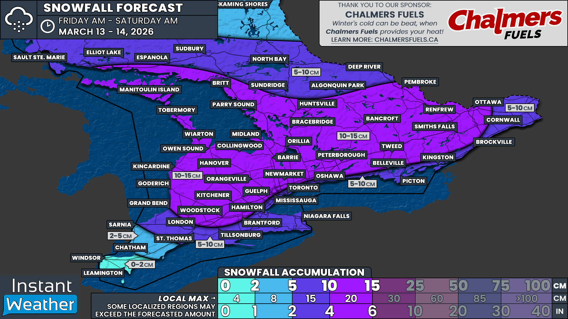
Once the system wraps up late Friday into early Saturday morning, most of Southern Ontario will be looking at around 10 to 15cm of fresh snow. That will bring back a familiar winter landscape that was wiped out in many areas thanks to the warm temperatures earlier this week.
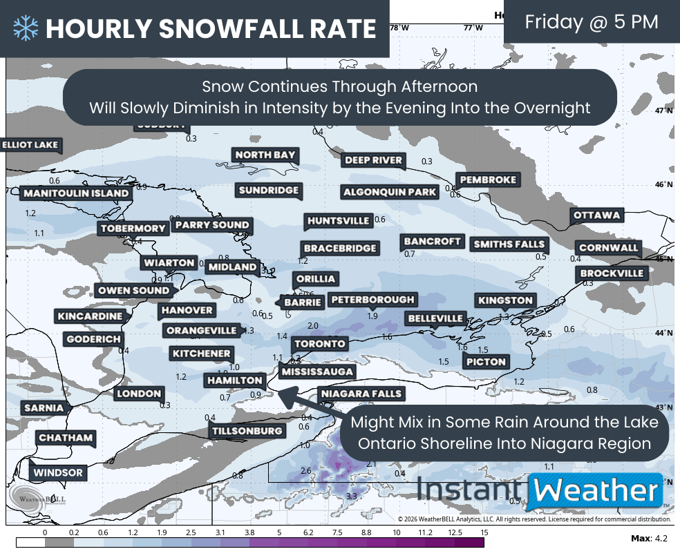
Hourly snowfall rates (cm) - MAP FROM WEATHERBELL
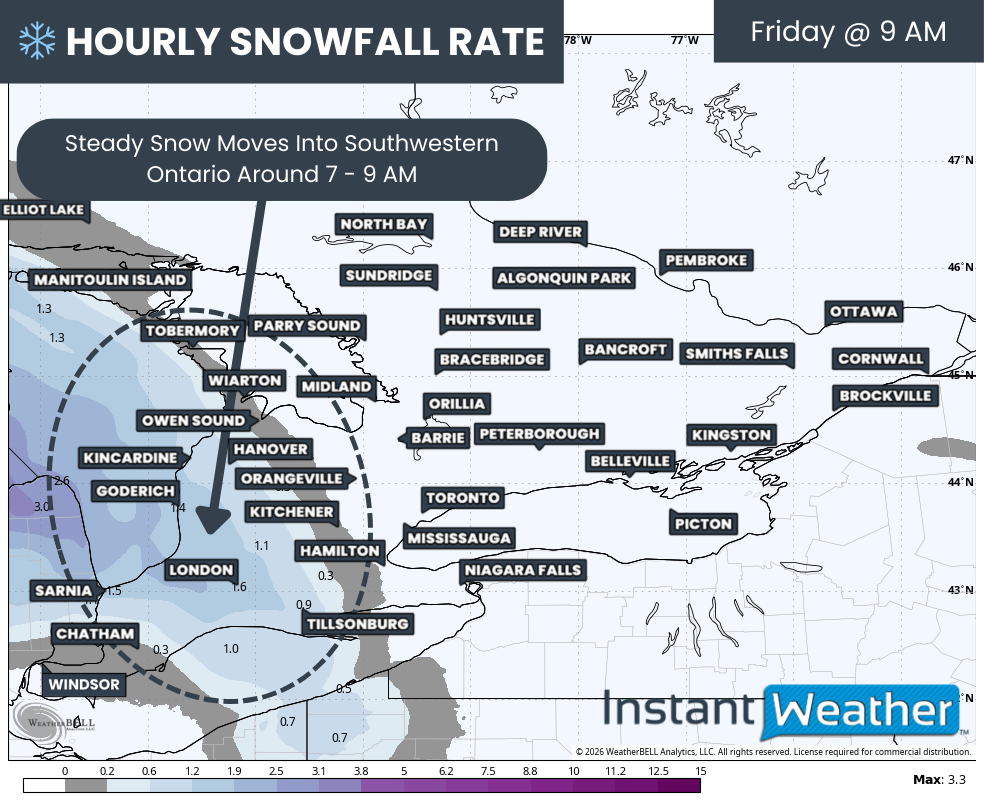
The first bands of snow are expected to begin working their way into Southwestern Ontario from the west just after sunrise on Friday morning.
That means locations around Lake Huron will likely be the first to experience the steady snowfall. The snow should start out fairly light early in the morning before gradually increasing in intensity.
For Deep Southwestern Ontario around the Windsor and Chatham area, it looks like they will be sitting right near the freezing mark. These areas could start off with some flurries during the pre-dawn hours, but little accumulation is expected.
As temperatures rise above freezing through the morning hours, precipitation will likely switch over to rain by the late morning, which will limit any snowfall accumulation in this region.
Hourly snowfall rates (cm) - MAP FROM WEATHERBELL
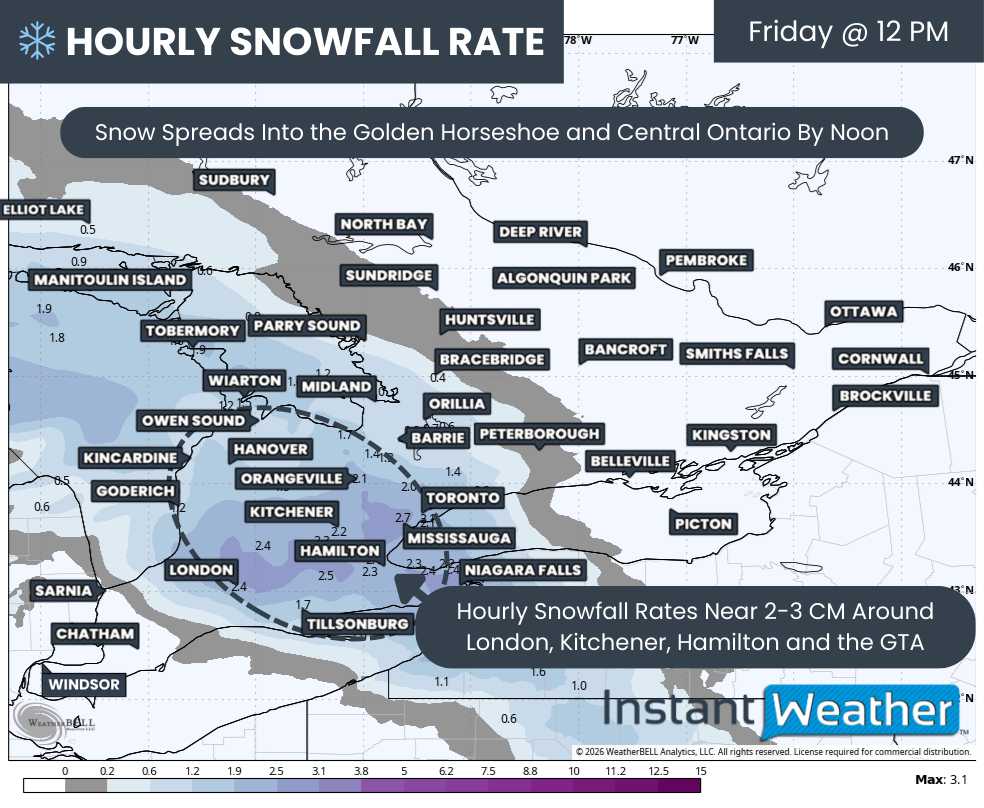
That swath of snow will pick up intensity through the late morning with it spreading eastward into the Greater Toronto Area and regions around Lake Simcoe by around the noon hour. As this occurs, snowfall rates are expected to increase across parts of the region.
It appears that an area of elevated snowfall rates approaching 2 to 3cm per hour could briefly set up in regions east of Lake Huron and into the Golden Horseshoe. Even though this intense snowfall would only last for a few hours, it could still lead to some rapid accumulation in a short period of time.
That burst of heavier snow could lead to some quickly deteriorating road conditions leading up to the afternoon commute and make for some slushy and snow covered roads.
It should be mentioned that temperatures in many of these areas will be sitting very close to the freezing mark. Because of that, it is possible that accumulation may not be as efficient as it would be during colder snowfall events.
Some of the snow may melt as it falls or shortly after reaching the ground, especially on roadways that were warmed by the recent mild weather.
We may even see some mixing along the Lake Erie and Lake Ontario shoreline, especially toward the mid to late afternoon hours when temperatures may briefly creep above freezing.
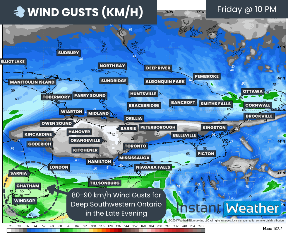
wind gusts (km/h) - MAP FROM WEATHERBELL
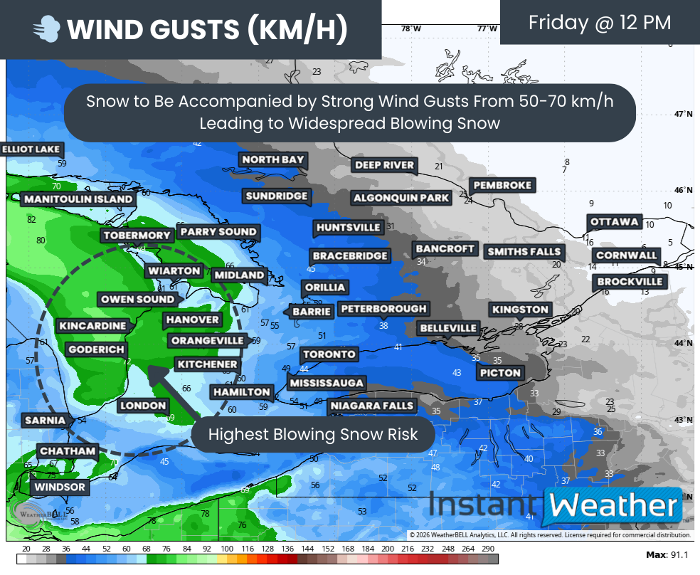
Another big factor that will enhance the impact of what would normally be considered a fairly uneventful snowfall event is the wind.
Earlier forecast data suggested much stronger and more widespread wind gusts, but recent model runs have toned those values down somewhat.
Even with that reduction, winds are still expected to be quite gusty with gusts near 50 to 70 km/h across Southwestern Ontario and the Golden Horseshoe. Closer to Lake Huron those gusts could approach 80 km/h at times.
Given the heavier snowfall rates of 2 to 3cm per hour at times, these gusts will likely lead to near zero visibility in some areas with widespread blowing and drifting snow developing.
There could even be some localized blizzard conditions east of Lake Huron, which is particularly vulnerable due to its exposed rural roads and open terrain. In these areas, snow can easily be picked up by the wind and blown across roadways, quickly reducing visibility and creating hazardous driving conditions.
Road closures cannot be ruled out in some of the more exposed locations, especially if blowing snow becomes intense during the peak of the storm.
Hourly snowfall rates (cm) - MAP FROM WEATHERBELL
Heading into the late afternoon hours, the snow will have spread into Central and Eastern Ontario, where it is expected to persist into the evening. Some of the areas further east may not see the snow fully taper off until early Saturday morning as the system gradually exits the region.
It appears that the overall intensity of the snow will slowly decrease by the evening hours, with snowfall rates closer to 1 to 2cm per hour in many areas.
The heaviest pockets during the evening appear to be focused on areas north of Lake Ontario such as York Region, Durham Region, Kawartha Lakes and Peterborough before eventually moving into parts of Eastern Ontario after the dinner hour. Hourly snowfall rates in these areas could still briefly exceed 2cm at times through the evening before gradually easing overnight.
For Southwestern Ontario and the Greater Toronto Area along the Lake Ontario shoreline, rising temperatures near the shoreline will likely lead to a switch from snow to rain by the late afternoon and early evening. This changeover will help limit snowfall totals closer to the lakes.
Another wave of light snow may move in from the west late in the evening and into the overnight hours as colder air flows in behind the departing system. However, this additional snow is not expected to produce significant accumulation.
wind gusts (km/h) - MAP FROM WEATHERBELL
We are also watching the evening hours closely for Deep Southwestern Ontario, where stronger wind gusts may develop just before midnight.
There is the potential for gusts reaching 80 to 90 km/h for areas such as Windsor, Chatham and Sarnia.
It is even possible that a few isolated severe wind gusts exceeding 90 km/h could occur in localized areas if the strongest winds are able to mix down to the surface.
NOTE: YOU CAN CLICK ON THE MAP TO OPEN A ZOOMABLE IMAGE

Overall, we are looking at general snowfall amounts of 10 to 15cm across much of Southern Ontario by Saturday morning.
A few pockets, especially in higher elevation areas like northwest of the Greater Toronto Area and the Dundalk Highlands, could see localized totals approaching 20cm thanks to slightly colder temperatures that will allow snow to accumulate more efficiently.
The 10 to 15cm zone includes Goderich, Kincardine, Owen Sound, Wiarton, Tobermory, Hanover, Orangeville, Kitchener, Guelph, Newmarket, Barrie, Collingwood, Midland, Orillia, Bracebridge, Parry Sound, Huntsville, Peterborough, Bancroft, Pembroke, Renfrew, Smiths Falls and Ottawa.
Slightly lower totals of 5 to 10cm are expected from London into the Niagara region and around the Greater Toronto Area near the Lake Ontario shoreline, continuing east into Kingston and up along the St. Lawrence River.
Temperatures are expected to rise above freezing in this corridor, especially during the afternoon hours, which could reduce the ability for snow to accumulate and even allow some rain to mix in at times.
That includes Grand Bend, London, St. Thomas, Tillsonburg, Niagara Falls, Hamilton, Mississauga, Toronto, Oshawa, Belleville, Picton, Kingston, Brockville and Cornwall.
To the north, lower snowfall totals of 5 to 10cm are also expected in locations such as Algonquin Park, Deep River, North Bay, Sudbury and Elliot Lake. This is mainly because the heavier precipitation bands are expected to stay south of these regions.
Around 2 to 5cm is expected for Sarnia and Chatham as they see rain for much of the event, with less than 2cm likely for the Windsor and Leamington area, where temperatures remain warm enough for precipitation to fall primarily as rain.


