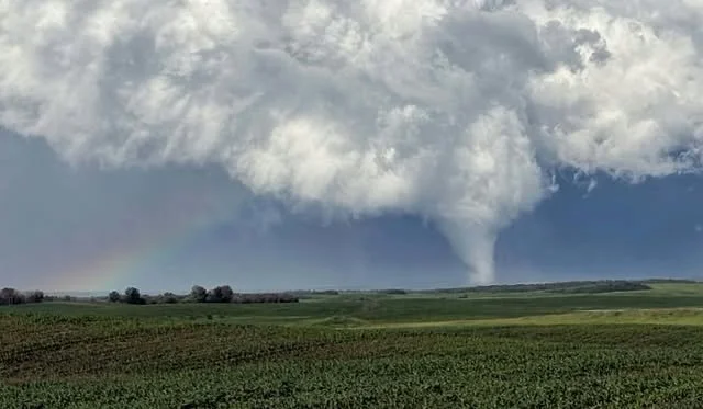
GTA in the Bullseye as Southern Ontario Faces Significant Storm Risk With Tornadoes, Destructive Winds and Timbit-Sized Hail Possible Saturday
/
NOTE: YOU CAN CLICK ON THE MAP TO OPEN A ZOOMABLE IMAGE
The persistent wildfire smoke that has blanketed Southern Ontario over the past several days is finally on the way out, but it will quickly be replaced by a very different threat.
A potentially significant severe weather event is expected across much of Southern Ontario on Saturday as a strong cold front sweeps through the region. The greatest risk is focused on the Greater Toronto Area and surrounding parts of the Golden Horseshoe, where an intense squall line could produce widespread destructive wind gusts, several tornadoes, large hail and flash flooding during the afternoon.
Toronto, Mississauga, Hamilton, Brampton, Vaughan, Oshawa and the surrounding region could be directly in the path of the most intense portion of the squall line.
Widespread wind damage and power outages will be possible if the squall line develops as currently expected. Flash flooding could also become a major concern across heavily urbanized areas, where torrential rainfall may quickly overwhelm drainage systems and flood roads or low-lying areas.
The severe threat will begin much earlier across cottage country, where isolated storms could develop as early as the late morning or around noon. These initial storms may have a greater chance of becoming supercells and producing tornadoes before they organize into a larger squall line.
This is especially concerning on a summer weekend when many people may be camping, boating or staying at cottages across Simcoe County, Muskoka, the Kawartha Lakes and Algonquin Park. Those in tents, trailers or boats could be particularly vulnerable to fast-moving storms producing destructive winds, large hail and tornadoes.
Anyone spending time in cottage country should have a reliable way to receive weather alerts, keep a close eye on the sky and identify a sturdy shelter before storms arrive. Cell service can be unreliable in some remote areas, so it is important to plan ahead rather than waiting for threatening weather to approach.
Join Us on YouTube for Storm Coverage:
We'll be providing comprehensive live coverage of any storms that develop Saturday on our YouTube channel. Our team will be tracking storms in real time with live radar analysis, warnings, and storm reports, so if severe weather threatens your area, be sure to join us live to help stay informed.
The overall severe threat will begin with scattered morning storms before rapidly increasing around noon and continuing through the afternoon. However, the exact strength and placement of the event will depend on how quickly those morning storms move out and whether lingering wildfire smoke limits daytime heating in Eastern Ontario.
DATA FROM WEATHERBELL
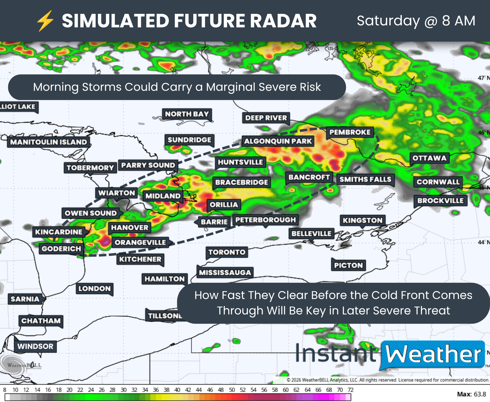
As we often see on days with a strong severe weather risk, there will be a morning storm component. Scattered storms are expected to develop from Lake Huron through areas east of Georgian Bay and into Algonquin Park between approximately 6 and 8 a.m.
While most of these storms should remain below severe limits due to their early timing, a few cells could still bring a marginal severe threat, with wind gusts approaching 90 km/h and hail up to the size of nickels.
More importantly, these storms will play a key role in determining how the severe threat unfolds later in the day. A cold front is expected to quickly follow the morning storms during the early afternoon.
If the morning activity lingers into the late morning, it could limit additional daytime heating before the cold front arrives. This would leave storms developing along the front with a less favourable environment that has already been worked over by the earlier storms.
DATA FROM WEATHERBELL
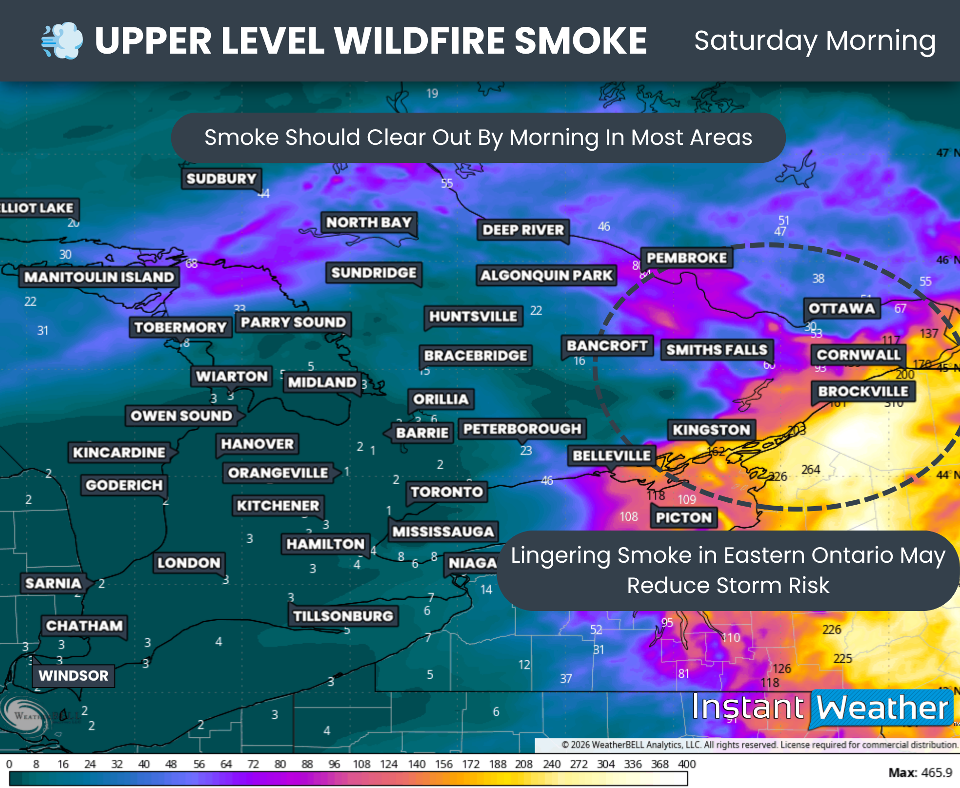
Another important factor is the persistent wildfire smoke from Northern Ontario that has been locked over Southern Ontario during the past several days.
Current models suggest the smoke should clear out of most of Southern Ontario by late Saturday morning. Based on the latest upper-level smoke data, it should be mostly confined to Eastern Ontario by noon.
This means Southwestern and Central Ontario, along with the Golden Horseshoe, should have no problem warming up as long as the morning storms do not linger for too long.
Eastern Ontario is more uncertain. With smoke potentially lingering into the afternoon, it could filter out enough sunlight to limit daytime heating and inhibit storm development. We recently saw this happen during what had initially appeared to be a strong severe weather threat in Quebec last week.
While it is unlikely that smoke will significantly affect storm development elsewhere in Southern Ontario, any unexpected delay in clearing could reduce the severe threat in some of the stronger risk areas. This remains a possible bust scenario, although it appears unlikely based on the latest data.
DATA FROM WEATHERBELL
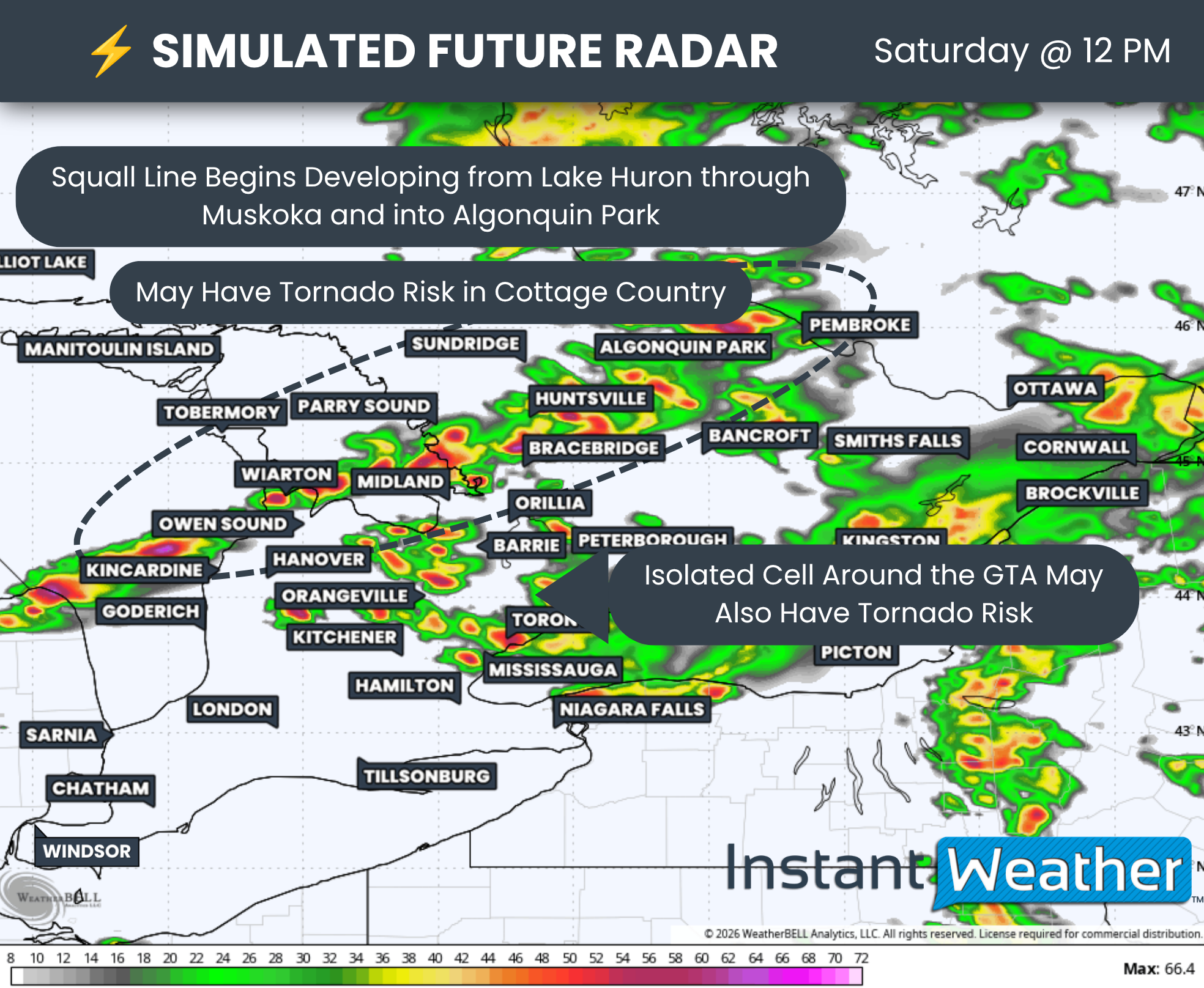
The threat will begin to build around noon as a cluster of storms develops from Lake Huron through cottage country and into Algonquin Park. This cluster is expected to eventually organize into a strong squall line, but the storms may remain more isolated during the first few hours of development.
That could allow the strongest tornado potential during the early stages of the event to focus on portions of cottage country. Anyone camping or spending time outdoors should have a reliable way to receive tornado alerts and remain weather aware, as these storms could move quickly and arrive with little notice.
We may also see isolated cells develop ahead of the main line before eventually being absorbed as the cold front races toward them. These isolated storms could present a tornado threat across portions of Simcoe County, York Region and the Greater Toronto Area.
DATA FROM WEATHERBELL
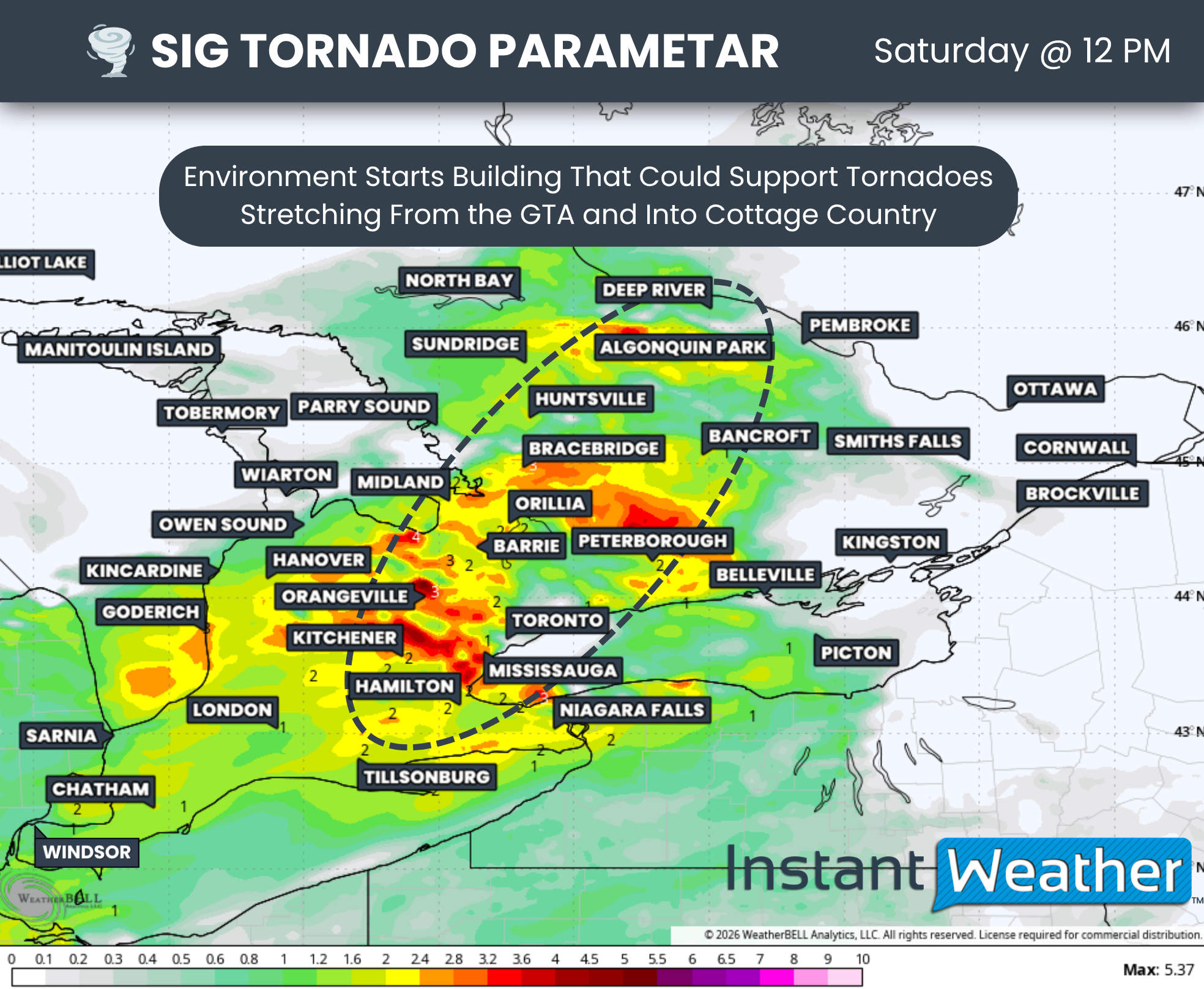
The latest Significant Tornado Parameter data, which highlights where the ingredients for tornado development may be strongest, focuses the greatest potential just west of Toronto around Kitchener, Orangeville and Barrie, extending northward into Bracebridge and Algonquin Park.
This parameter only shows where the environment may be supportive. Storms still need to develop and take advantage of those ingredients.
However, it suggests that any storms that do form could quickly present a tornado threat beginning as early as noon, with the risk continuing to build through the early afternoon.
DATA FROM WEATHERBELL

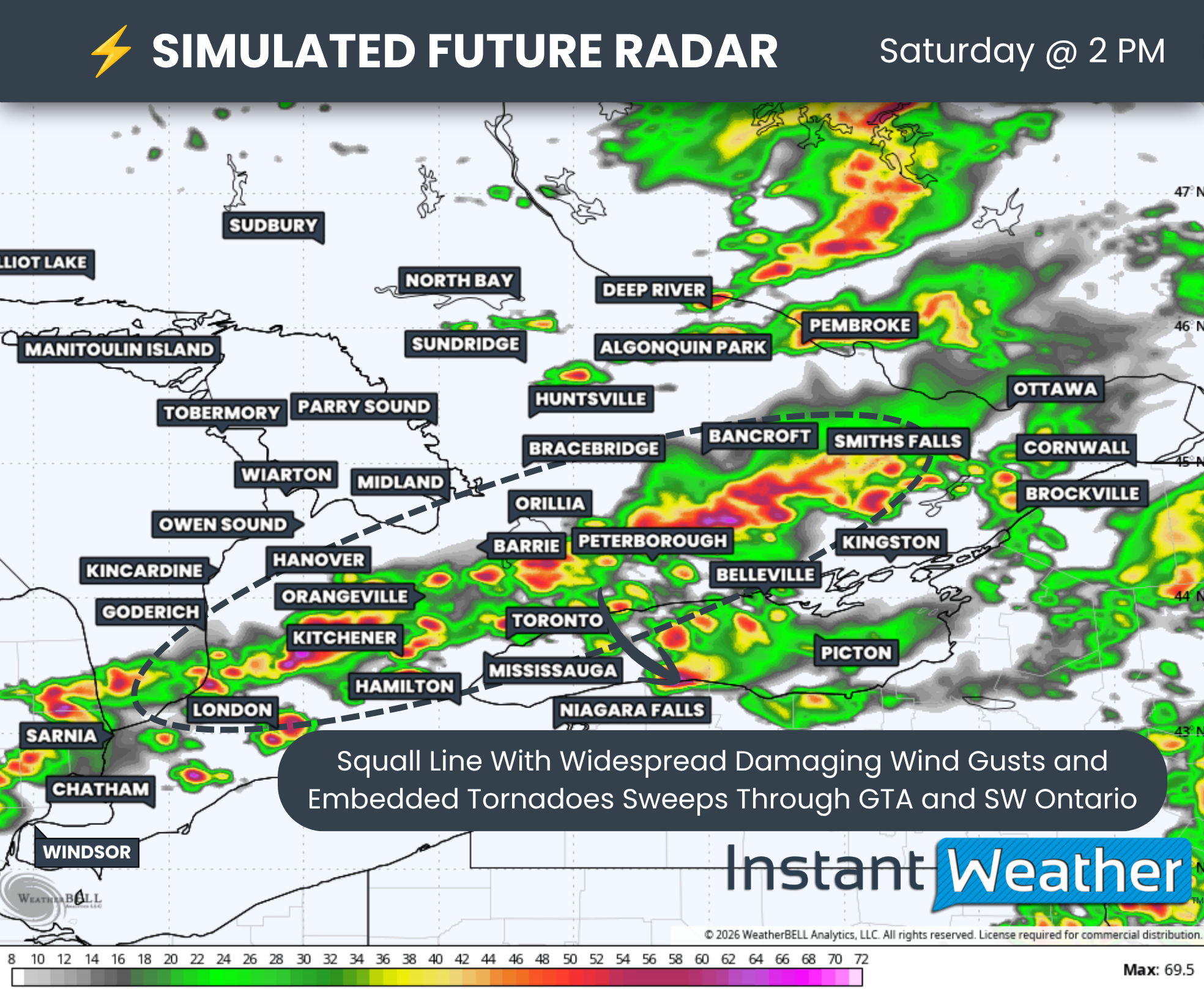
By the middle of the afternoon, a maturing squall line attached to the cold front is expected to sweep southeastward into a highly favourable severe weather environment.
This environment will extend from Sarnia through Kitchener and into the Golden Horseshoe, potentially reaching the Peterborough to Kingston corridor.
At this point, the primary threat should transition to destructive wind gusts, potentially affecting a wide area along the line.
A few QLCS (Quasi-Linear Convective System) tornadoes, which can develop quickly within a squall line, will also be possible. Embedded supercells or isolated supercells immediately ahead of the line could bring an additional tornado threat.
The squall line is expected to continue southeastward while strengthening as it approaches Lake Ontario and Lake Erie before eventually crossing into the United States.
Since the line may strengthen as it tracks southeastward, the Greater Toronto Area, Niagara Region and communities along the northern shoreline of Lake Erie could face the greatest threat. Widespread wind damage will be possible if the line develops as currently expected.
DATA FROM WEATHERBELL
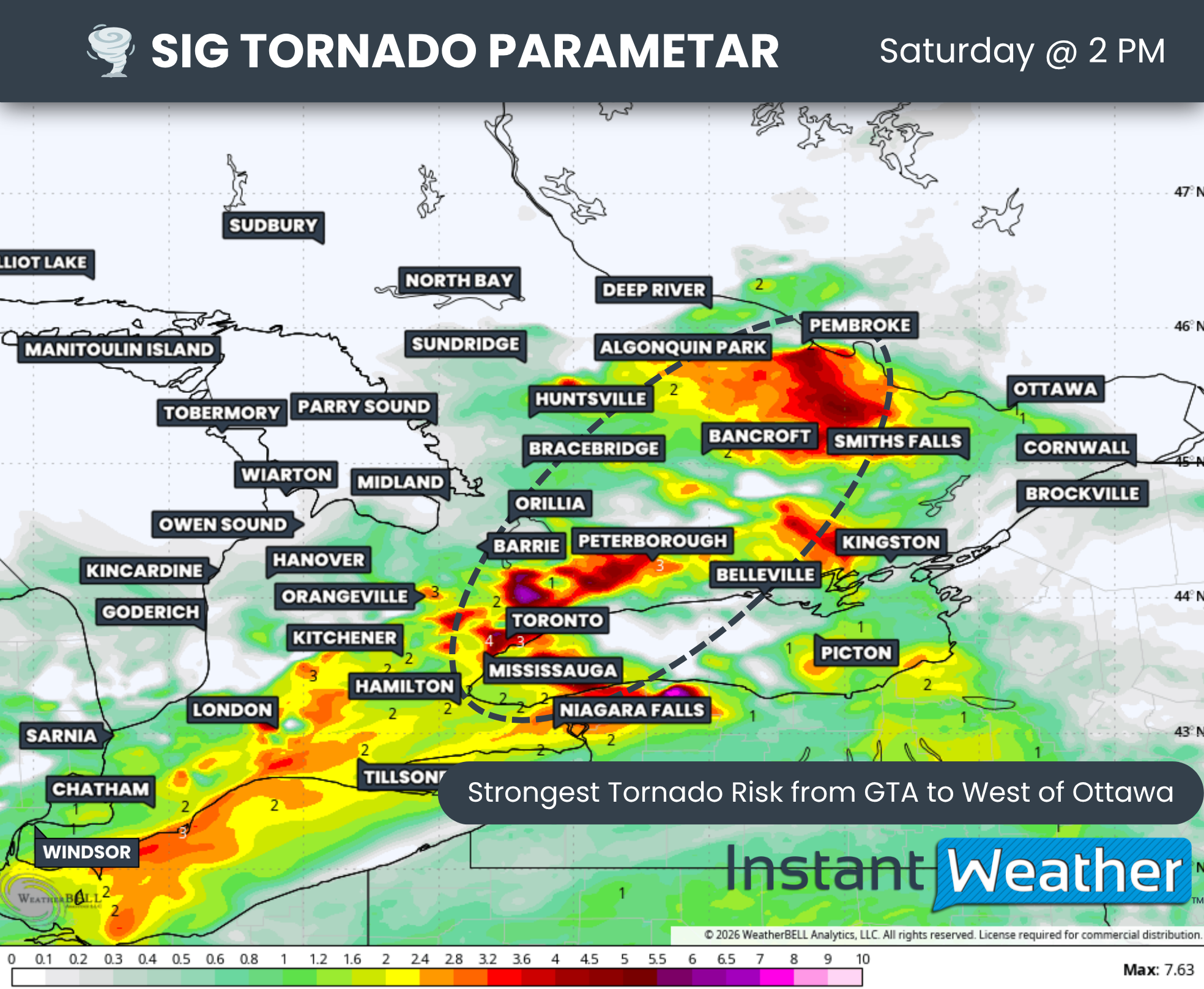
By the middle of the afternoon, between approximately 2 and 3 p.m., Significant Tornado Parameter data shows an increasingly favourable environment for tornado development across the Greater Toronto Area and from areas east of Lake Simcoe through Peterborough.
There is also a conditional threat west of Ottawa if storms can develop behind the cold front after it moves through Algonquin Park, Pembroke and Renfrew. However, storm development in this area is much more uncertain.
A slight tornado risk will also extend farther southwest into Kitchener, London and Chatham. Isolated supercells developing ahead of the squall line could acquire rotation before being overtaken by the main line.
The tornado threat will shift into Niagara Region and the Kingston to Brockville corridor later in the afternoon, generally between 3 and 5 p.m., as the squall line approaches those areas.
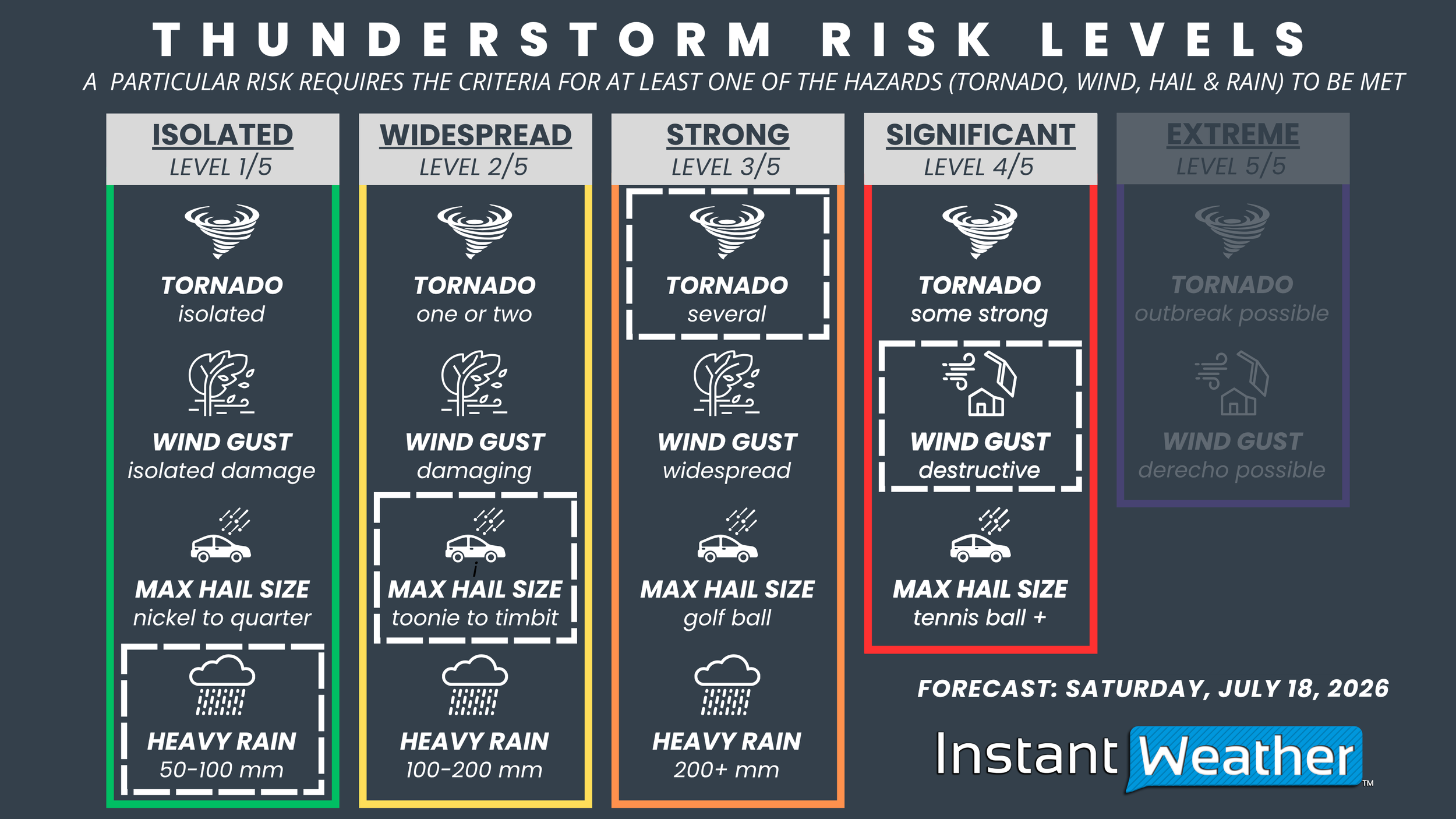
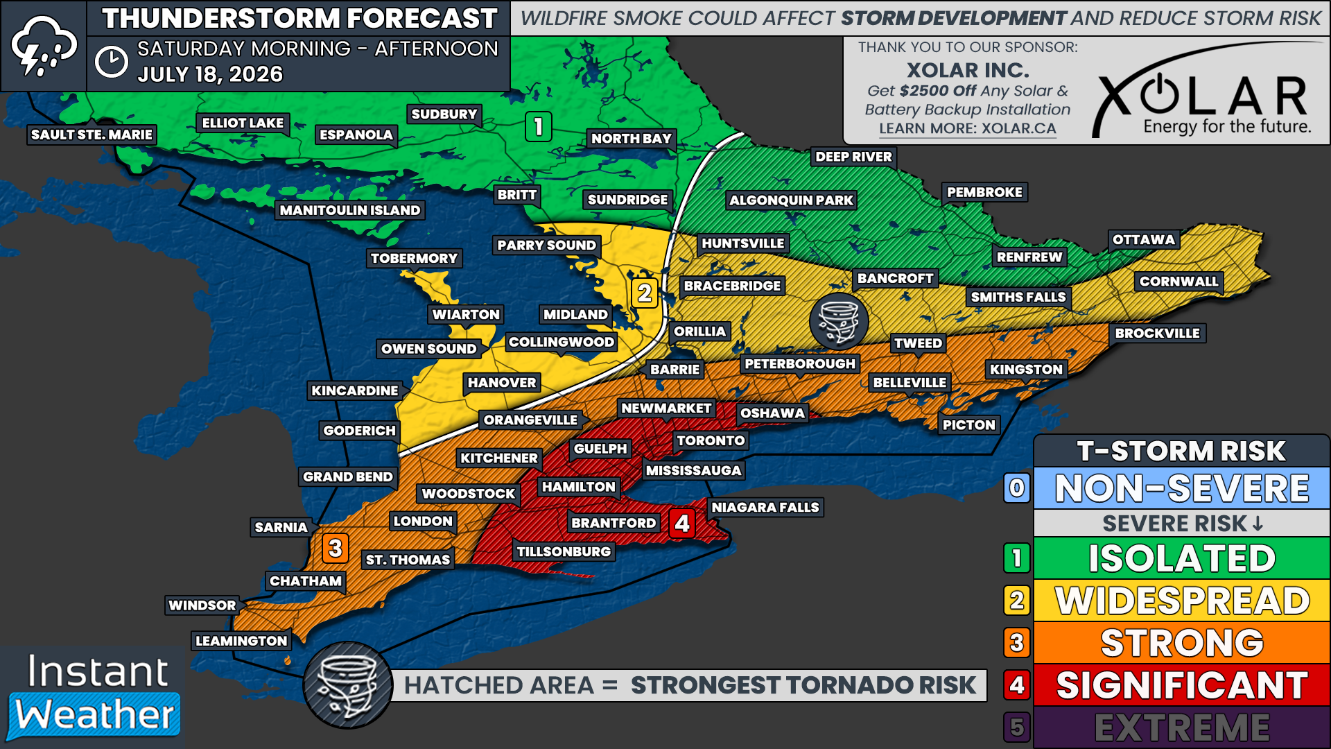
The highest severe risk on Saturday is currently focused on the Golden Horseshoe, including Toronto, Hamilton, Mississauga, Kitchener, Guelph, Brantford, Niagara Falls, Newmarket and Oshawa.
We have placed these areas under a “significant” risk, which is level four out of five on our severe weather risk scale.
This risk is primarily driven by the potential for widespread destructive wind gusts accompanying an intense squall line during the early to middle afternoon.
Several tornadoes will also be possible within this region, especially if isolated supercells develop ahead of the main line. Hail up to the size of toonies or Timbits will also be possible.
Flash flooding could become a major concern, particularly throughout heavily urbanized areas. These locations are more vulnerable to significant rainfall over a short period because pavement and other hard surfaces prevent water from quickly soaking into the ground.
A fairly expansive “strong” risk, which is level three out of five, includes Windsor, Chatham, Sarnia, London, Grand Bend, Orangeville, Barrie, Peterborough, Belleville, Kingston and Brockville.
These areas could see one or two tornadoes, along with widespread damaging wind gusts. Large hail up to the size of Timbits will also be possible.
The “widespread” risk, which is level two out of five, covers Grey and Bruce counties, areas east of Georgian Bay, Muskoka, Bancroft, Smiths Falls and Cornwall.
Damaging wind gusts and large hail up to the size of toonies will be possible. An isolated tornado cannot be ruled out, especially east of Georgian Bay through cottage country.
While we have assigned an isolated risk to the Ottawa Valley and Algonquin Park, this is mainly because storm development is more uncertain in these areas. They are also not expected to be directly affected by the intense squall line.
Any severe threat here will likely come from isolated storms developing during the late morning or early afternoon, potentially after the cold front moves through. An isolated tornado will be possible across Algonquin Park and the Ottawa Valley if storms are able to develop.