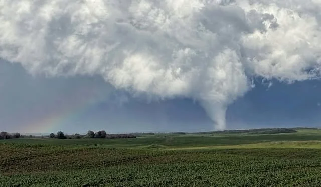
Dangerous Tornadic Supercells Capable of Massive Hail & Destructive Wind Gusts Possible Northeast of Edmonton Saturday; Strong Severe Thunderstorm Risk Extends Across Alberta & Saskatchewan
/
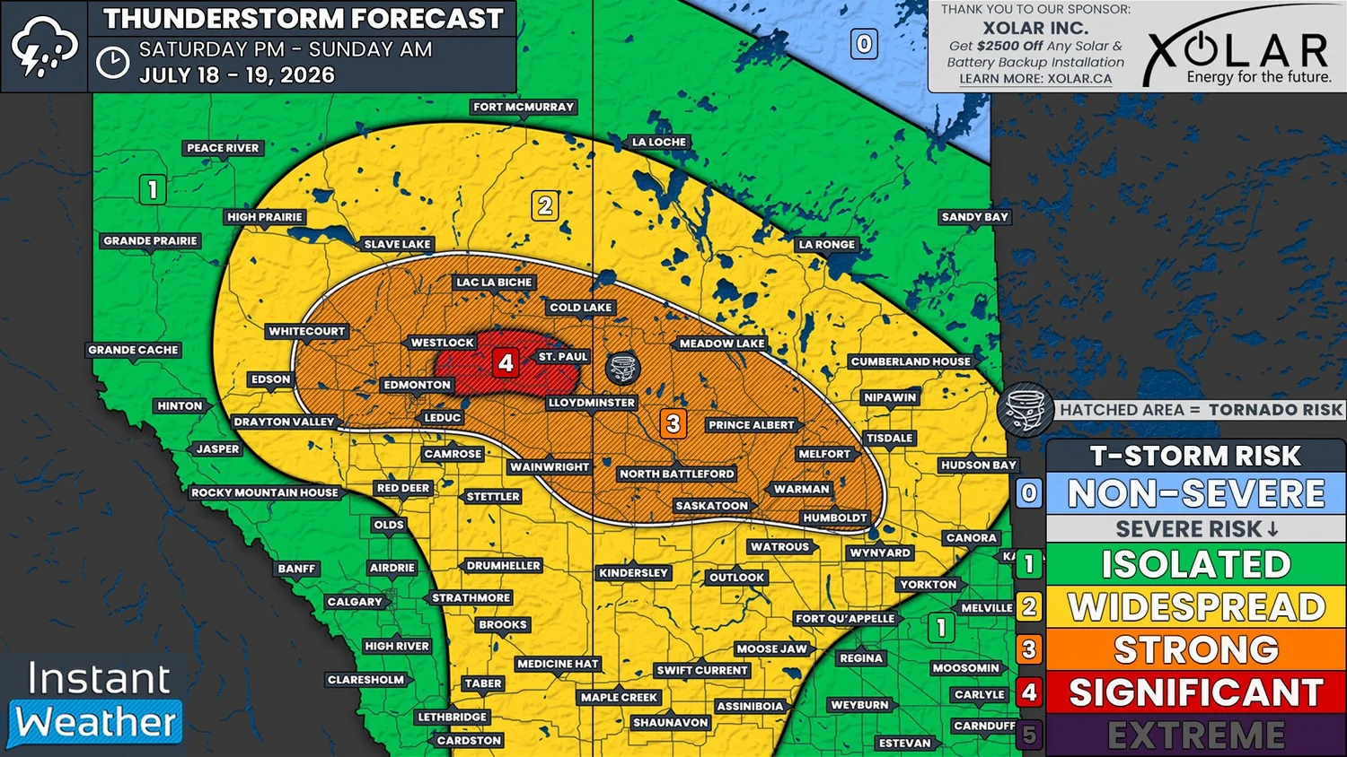
NOTE: YOU CAN CLICK ON THE MAP TO OPEN A ZOOMABLE IMAGE
The week of daily severe weather risk in Alberta continues on Saturday, and much of Saskatchewan, with the greatest threat we’ve seen so far this week.
Not only are we looking at the possibility of strong severe thunderstorms across a considerable stretch of both Alberta and Saskatchewan today, but there is also the risk for some significantly strong storms to the east and northeast of Edmonton, in an area that includes Vegreville and St. Paul.
Today’s environment will be primed for the formation of strong supercell thunderstorms.
Models are showing that there will be an incredible amount of instability across the region today, with well over 3000J/kg of CAPE (Convective Available Potential Energy) expected for the Edmonton area. CAPE values of this magnitude are very uncommon for areas this far north, which indicates how strong of a risk we are truly looking at.
Dew points in the upper teens to low 20s today will provide plenty of moisture. Combined with the significant amount of shear that’s expected through the atmosphere, supercell storms will be easily supported.
Overall, we’re looking at a very dangerous setup that would look more at home in the Great Plains of the United States, not in Central Alberta and Saskatchewan.
A low that is set to develop this afternoon, and its associated cold front, will be the trigger for today’s severe weather. The location of this low will be the key to where the very strong thunderstorms will end up impacting.
As it stands, it appears that the low will set up over Edmonton, which would bring the greatest severe threat to areas northeast and east of the city.
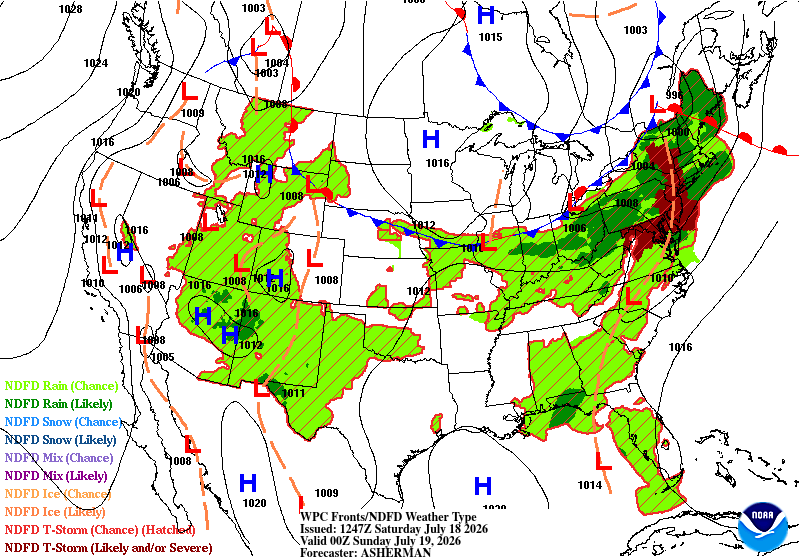
Future Surface weather map with the positions of highs, lows, and fronts displayed for 6pm MDT/CST on Saturday, courtesy of the national weather service.
There have already been some severe thunderstorms in Northern Alberta and Southeastern Saskatchewan this morning, but these will just be a precursor of what’s to come.
Additional storms could begin to initiate early this afternoon, mostly in the Foothills, but there could be some isolated development across Central Alberta and into Saskatchewan. As we progress through the afternoon, we are expecting to see more storms develop, all of which will move along a mostly northeastward trajectory.
The greatest severe threat will be through in the evening and into the overnight hours, as the storms encounter their most ideal environmental conditions. The strongest of these storms will likely impact areas to the northeast of Edmonton later in the evening, approximately from 10pm to midnight, give or take an hour.
Through the overnight hours, the storms will eventually weaken, but there will still be a slight severe risk that continues into the pre-dawn hours.
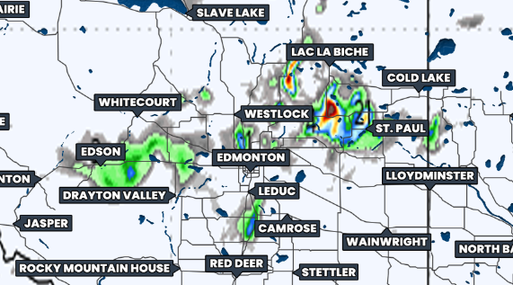
Hourly Precipitation at 11Pm MDT/CST, courtesy of weatherbell.
As we’ve mentioned, the area to the northeast of Edmonton is under a significant severe weather threat today. The storms that hit this region could potentially produce massive baseball size hail and destructive wind gusts that could be upwards of 130km/h, possibly even higher.
There is also a strong severe risk the covers a large portion of Central Alberta and Saskatchewan, that also extends into Northern parts of both provinces.
The entirety of the area under both the Strong and Significant severe risks today will also have the threat of tornadoes developing. The greatest risk for multiple, possibly strong, tornadoes, however, will be in that Significant risk as well as the surrounding area.
This could end up being a very dangerous day so it is crucial to have a plan in place in the event of tornado warning for your area. You’ll need to know where the best place to take shelter is: the most interior room of the lowest floor, away from any windows.
It’s also very important to have all of your devices charged and to have multiple ways to receive weather alerts.
We have already begun live streaming the severe weather ongoing in Southern Ontario and we will be extending our coverage to include Alberta and Saskatchewan once things start to fire up later. Be sure to join us as www.instantweather.ca/live!