Second Storm This Week Will Dump Even More Snow Across Saskatchewan & Manitoba This Weekend
/NOTE: YOU CAN CLICK ON THE MAP TO OPEN A ZOOMABLE IMAGE
We hope you’ve kept your shovels handy following the storm earlier this week because there is even more snow on its way for Saskatchewan and Manitoba this weekend.
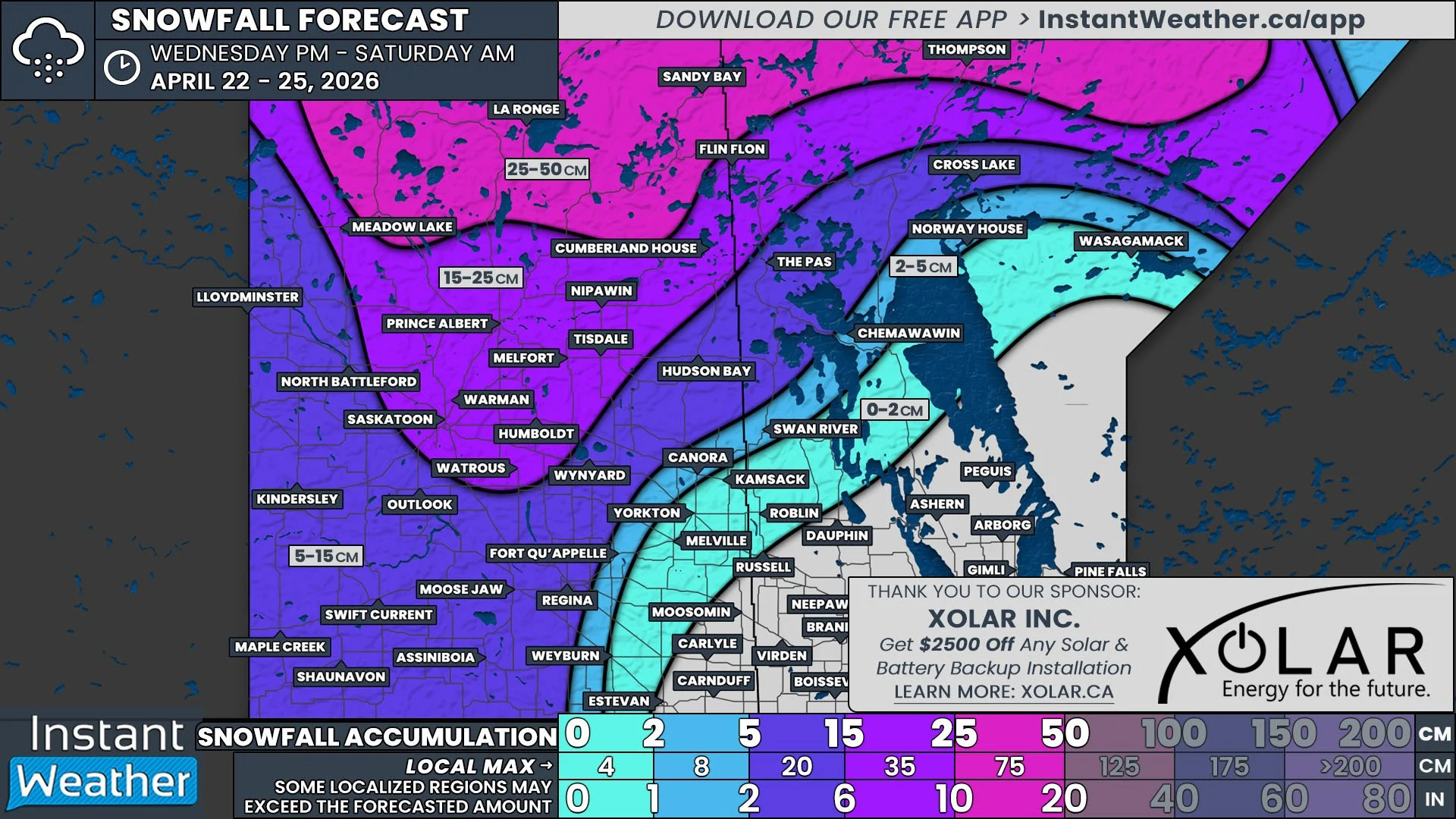
Thankfully this storm will be less complex than the previous one and the situation in two particular areas will be different this time around. The western edge of Saskatchewan, where next to no snow fell during the previous storm, is now in the crosshairs with more than 20cm of snow expected. Meanwhile, those in Winnipeg and the Eastman Region, who received drenching rains within the warm sector of the earlier storm, will finally see some snow, but overall accumulations will be limited.
Since last night’s preliminary forecast, model data has trended slightly to the north. This means that areas along the boundaries from the previous forecast could see either an increase or decrease in projected snowfall totals.
We’ve already seen a bit of light snow pushing its way into Southwest Saskatchewan from Alberta this afternoon and while this snowfall is associated with the expected storm, its a precursor band that will bring less than 5cm of snow to a small area that includes Maple Creek and Shaunavon.
The main event will begin Saturday morning, as the more organized band of snow pushes into Saskatchewan. It will start as light snow, but gradually intensify through the late morning and continuing overnight as the storm makes its way across the province. The heaviest snow is expected to fall mostly in Western Saskatchewan, leading to over 20cm of accumulation from Kindersley to Wynard by Sunday morning. At that point, there will only be some lingering light snow in Northern Saskatchewan that will continue into Monday morning.
The snow will remain steady as it crosses into Manitoba starting Saturday evening in the Westman Region and then the Parkland Region around midnight. The storm will begin to lose intensity by the time it moves into the Interlake Region on Sunday morning and as a result, there will be a decrease in snow accumulation down to 5-10cm, with only light snow falling for the remainder of the day. Since the storm will have a slight northeasterly trajectory as it crosses Manitoba, communities along the American border and into Winnipeg will see less than 5cm of snow fall.
The snow will begin to taper off Monday morning across Manitoba, with some scattered flurries continuing until late in the day, at which time the storm will exit the region.
One of the biggest challenges during the last storm was the blowing snow due to high winds. While the winds are not expected to be quite as intense this time around, gusts up to 50km/h could reduce visibility and result in some road closures, particularly through Southern Saskatchewan.


