Widespread Severe Thunderstorm Risk Across the Northern Prairies Thursday; Tornado Threat in Northern Saskatchewan
/
NOTE: YOU CAN CLICK ON THE MAP TO OPEN A ZOOMABLE IMAGE
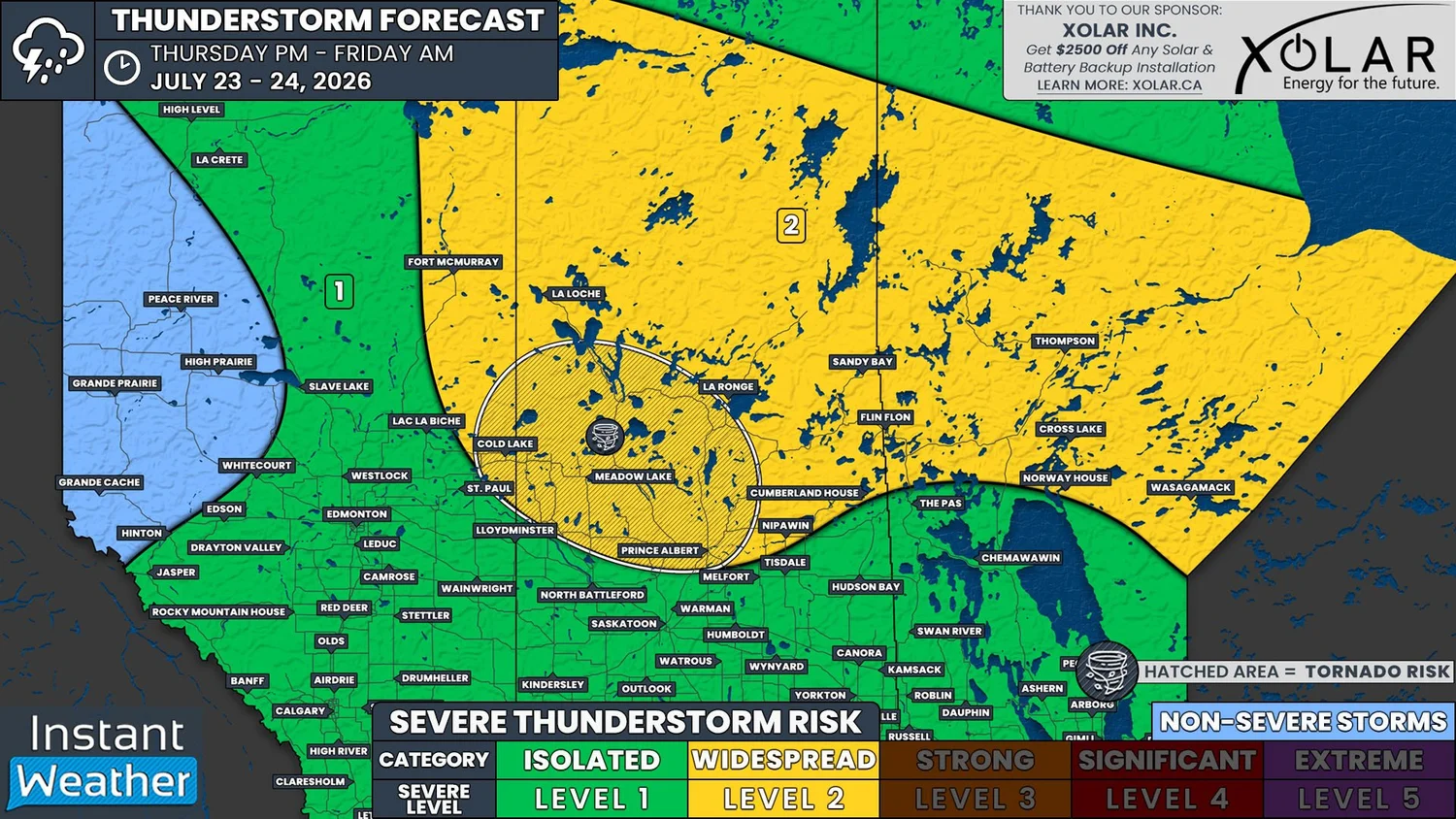
Today, there will be the widespread potential for severe thunderstorms across Northern Saskatchewan and Manitoba, and into parts of Northern Alberta. Meanwhile, most of the rest of the Prairies will be under a more isolated risk.
A low that is over Northern Alberta this morning will move into Saskatchewan this afternoon and its cold front will be the trigger for thunderstorm development. Although there won’t be a great deal of instability, with CAPE values below 1000J/kg for most of the region, there will be more than enough shear to still support thunderstorms once they form, especially for more southern areas.
We are already seeing some non-severe thunderstorms this morning in Northeastern Alberta and Northwestern Saskatchewan. It’s possible that one or two of these storms could become severe, especially if they can persist into the afternoon.

Hourly Precipitation at 7Pm MDT/CST, 8pm CDT , courtesy of weatherbell.
It’s during the afternoon that we are expecting to see additional development across the Northern regions of all three Prairie provinces, which will gradually track eastward with the low through the evening and overnight.
For the most part, we’re expecting that these will be garden variety severe thunderstorms across the region, with the main threat being strong wind gusts that could exceed 100km/h along with the possibility of up to toonie size hail and heavy rain.
There is, however, a slightly stronger severe risk in parts of Northern Saskatchewan and crossing the border into Alberta. This particular area, which includes Cold Lake, Meadow Lake, and Prince Albert, could potentially see storms that are capable of producing up to golf ball size hail, as well as an isolated tornado.
The presence of wildfire smoke in the atmosphere could certainly hinder thunderstorm development today, especially where the smoke is much thicker, closer to the Northwest Territories border. The good news is that we’re expecting today’s thunderstorms to be very moisture-laden, and there is also the possibility of widespread heavy rain not associated with thunderstorm activity. This will be beneficial for firefighting efforts across Northern Saskatchewan and Manitoba, as long as no additional fires are ignited by lightning strikes.