Widespread Tornado Threat in Saskatchewan and Manitoba to Start the Last Week of August
/
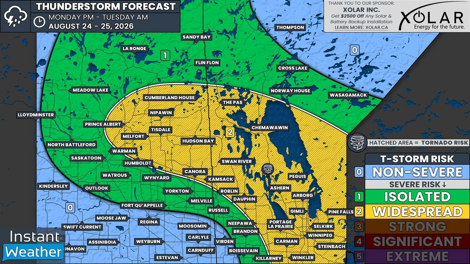
NOTE: YOU CAN CLICK ON THE MAP TO OPEN A ZOOMABLE IMAGE
After an extremely active beginning to the summer in June and July, in which we saw very strong severe thunderstorms and Environment Canada issue an Extreme Risk on more than one occasion, it’s been almost eerily calm this month for much of Manitoba and Eastern Saskatchewan.
That is going to change today because we are looking at a widespread risk of severe thunderstorms, that will also have a tornado threat, across the majority of Central and Southern Manitoba and into East Central Saskatchewan.
There has already been some thunderstorm activity in both Saskatchewan and Manitoba this morning that continued from overnight. Most of these storms have been non-severe, but a few storms have surpassed the severe threshold and have produced some moderate hail and strong wind gusts.
These storms are expected to continue to gradually weaken as we move into the early afternoon, but how long they end up persisting could impact the severity of the storms that are expected to develop across the region later this afternoon and evening.
The environment today will have ample moisture and instability to support severe thunderstorm development, particularly in Southern Manitoba, where supercells will be possible as storms track eastward through the evening. Storms in this region are expected to be able to produce hail larger than golf balls and damaging wind gusts in excess of 100km/h.
Weather models are also indicating a tornado risk across Southern Manitoba, but the greatest threat appears to be to the west of Winnipeg and includes Winkler, Portage la Prairie, and into the Parkland Region.
Moving northward and into East Central Saskatchewan, the environment will not be quite as favourable, but there will still be a widespread severe risk that begins early this afternoon and continues into the overnight hours. The thunderstorms across this region will also be able to produce large hail, albeit likely slightly smaller than in Southern Manitoba, and strong wind gusts that could approach 100km/h.
Although this area is not expected to see supercell thunderstorms, Environment Canada has noted that there will be the potential for landspouts (non-supercell tornadoes), especially in East Central Saskatchewan this afternoon.
With today’s severe weather setup including the risk of tornadoes over such a wide area, the Instant Weather team will definitely be live streaming this afternoon. Be sure to tune in at instantweather.ca/live!