Southern Ontario Could Soar Near 20°C This Weekend as ‘March Melt’ Triggers Rapid Snowmelt, Flooding Risk and Thunderstorms
/

NOTE: YOU CAN CLICK ON THE MAP TO OPEN A ZOOMABLE IMAGE
After what felt like a winter that would never end across Southern Ontario, our first widespread taste of spring-like weather is finally on the horizon just in time for the weekend.
While parts of Southwestern Ontario have already seen brief stretches of double-digit temperatures this year, those warmer readings have been fairly localized. That is about to change on Saturday as temperatures are expected to soar well into the double digits across most of Southern Ontario. There is even a chance that Deep Southwestern Ontario could see the first 20°C day of the year.
Unfortunately, this warm-up will come at a cost. The milder temperatures will arrive alongside heavy rainfall and embedded thunderstorm activity beginning Friday evening and continuing through much of Saturday.
As the warmer air moves in, it will also bring a more unstable atmosphere. Because of this, there is a conditional risk for marginally severe storms in parts of Southwestern Ontario extending toward the Niagara region. There remains quite a bit of uncertainty with this threat, as storms will have to contend with the very cold waters of Lake Huron and Lake Erie, which can act as a natural storm shield for Southern Ontario.
Another concern with this system is the flooding potential. The combination of double-digit temperatures and heavy rainfall over an area that still has a fairly significant snowpack, especially across Central Ontario, could lead to rapid snowmelt and rising water levels.
Current model guidance suggests that this brief warm spell could trigger rapid melting of the snowpack. This would introduce a large amount of additional water into local rivers and watersheds on top of the 25 to 50 mm of rainfall that is expected from this system.
Those in areas that are prone to spring flooding should begin preparing for the possibility of rising water levels over the next several days into early next week. As the snowpack melts and rain continues to fall, that water will gradually work its way through the watershed. Additional rainfall toward the middle of next week, combined with another round of double-digit temperatures, could further worsen the situation.
SIMULATED RADAR - MAP FROM WEATHERBELL
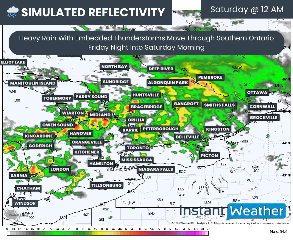
The first round of heavier rainfall is expected to develop late Friday and continue into the overnight hours. This area of rain may also contain embedded non-severe thunderstorms, particularly around Lake Huron and Georgian Bay, extending eastward into parts of Eastern Ontario.
These pockets of storms may produce locally heavier rainfall totals along with small hail and frequent lightning strikes.
SIMULATED RADAR - MAP FROM WEATHERBELL
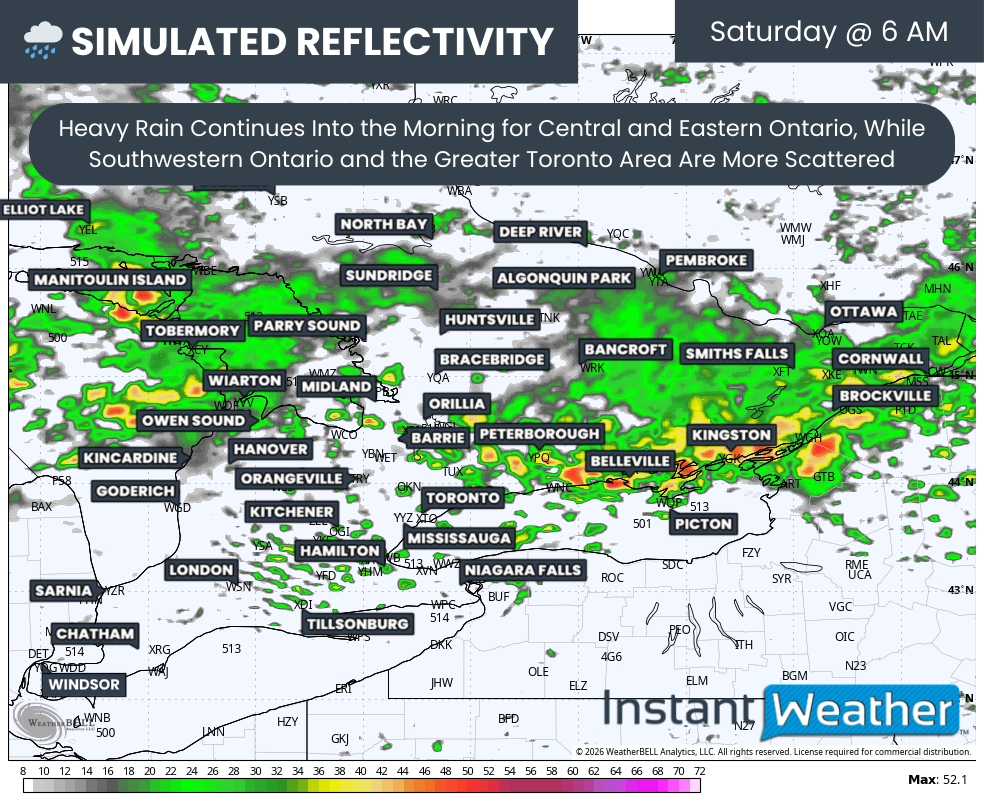
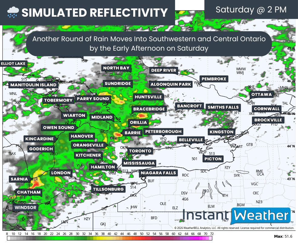
By mid-morning on Saturday, areas from Southwestern Ontario into the Greater Toronto Area should see a brief break from the heavier rainfall. Periods of drizzle may continue through the rest of the morning while the focus for heavier rain and thunderstorms shifts toward Eastern Ontario before gradually moving out by around the lunch hour.
SIMULATED RADAR - MAP FROM WEATHERBELL
Another cluster of heavy rain and embedded thunderstorms is expected to develop and move into Southwestern Ontario sometime during the late morning or early afternoon hours. There remains some disagreement among forecast models regarding the exact intensity of this line as it crosses Southern Ontario.
It cannot be ruled out that a marginally severe storm could develop within this cluster. The main threats would be damaging wind gusts and large hail. This risk appears to be slightly higher around the Niagara region, where storms could move into an environment that becomes more favourable for severe weather through the early to mid-afternoon hours.
SIMULATED RADAR - MAP FROM WEATHERBELL
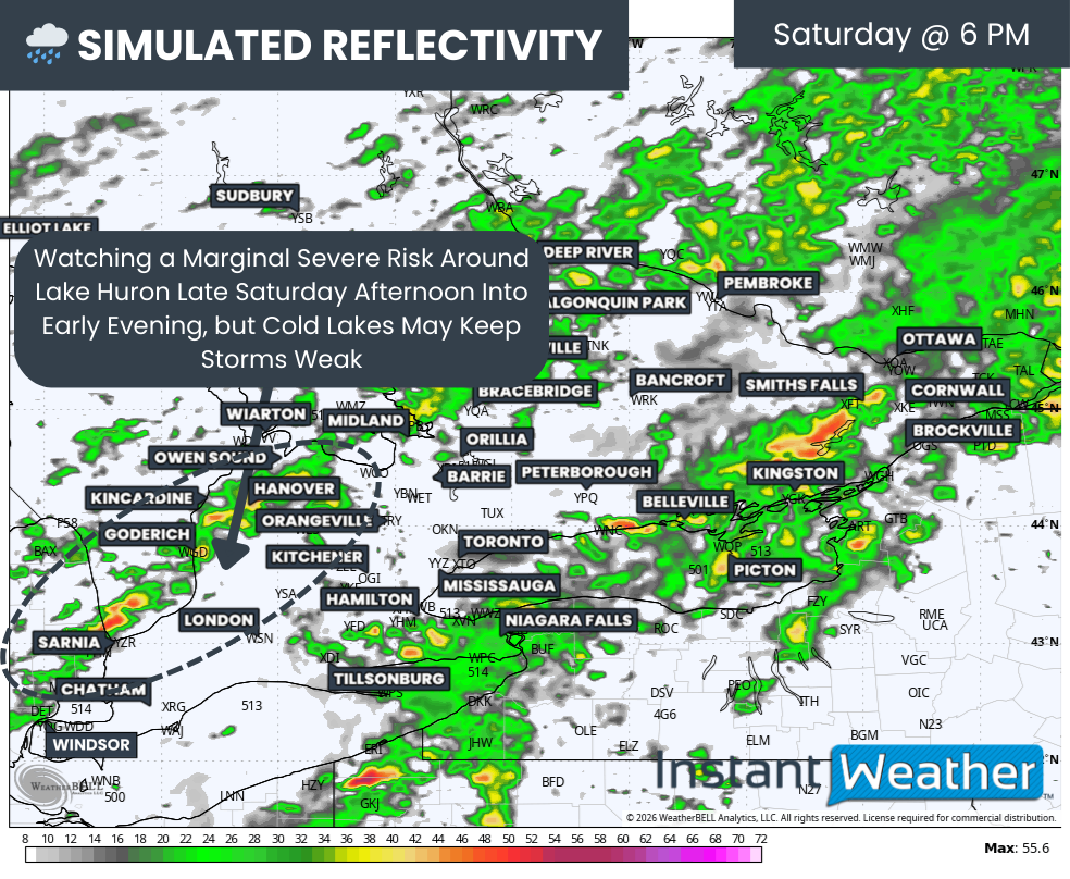
After this cluster moves through, there is also the possibility of additional isolated storms developing over Michigan and Lake Huron. These storms could then track into Southwestern Ontario by the late afternoon or early evening hours.
This time period may present the greatest severe weather potential of the day. However, there is still uncertainty related to the timing of the earlier cluster of storms. If that earlier activity clears out quickly enough, it would allow the atmosphere time to recover and become unstable again by late afternoon, creating a more supportive environment for additional storm development.
Another important factor is the time of year. This would be our first thunderstorm risk of the season, and the lakes remain extremely cold. When storms move over these cold waters, they often weaken, which can limit their ability to become severe. This is one reason why early-season storm risks across Southern Ontario often underperform expectations.
NOTE: YOU CAN CLICK ON THE MAP TO OPEN A ZOOMABLE IMAGE
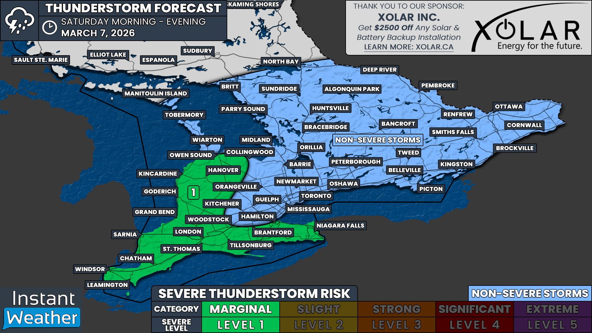
Because of this uncertainty, we are currently forecasting a level 1 out of 5 severe weather risk, also known as a marginal risk. This represents the potential for storms capable of producing wind gusts up to around 90 km/h, hail up to quarter size and brief heavy rainfall. While the tornado risk appears to be fairly low, it can never be completely ruled out when dealing with severe thunderstorms.
Locations within the marginal risk area include Windsor, Chatham, Sarnia, London, Grand Bend, Goderich, Kincardine, Owen Sound, Hanover, Brantford, Hamilton and Niagara Falls.
Across the rest of Southern Ontario, including the Greater Toronto Area, Central Ontario and Eastern Ontario, there will still be a chance for thunderstorms. However, most of these storms are expected to remain below severe limits and will likely occur during the overnight hours into Saturday morning and early afternoon.
NOTE: YOU CAN CLICK ON THE MAP TO OPEN A ZOOMABLE IMAGE

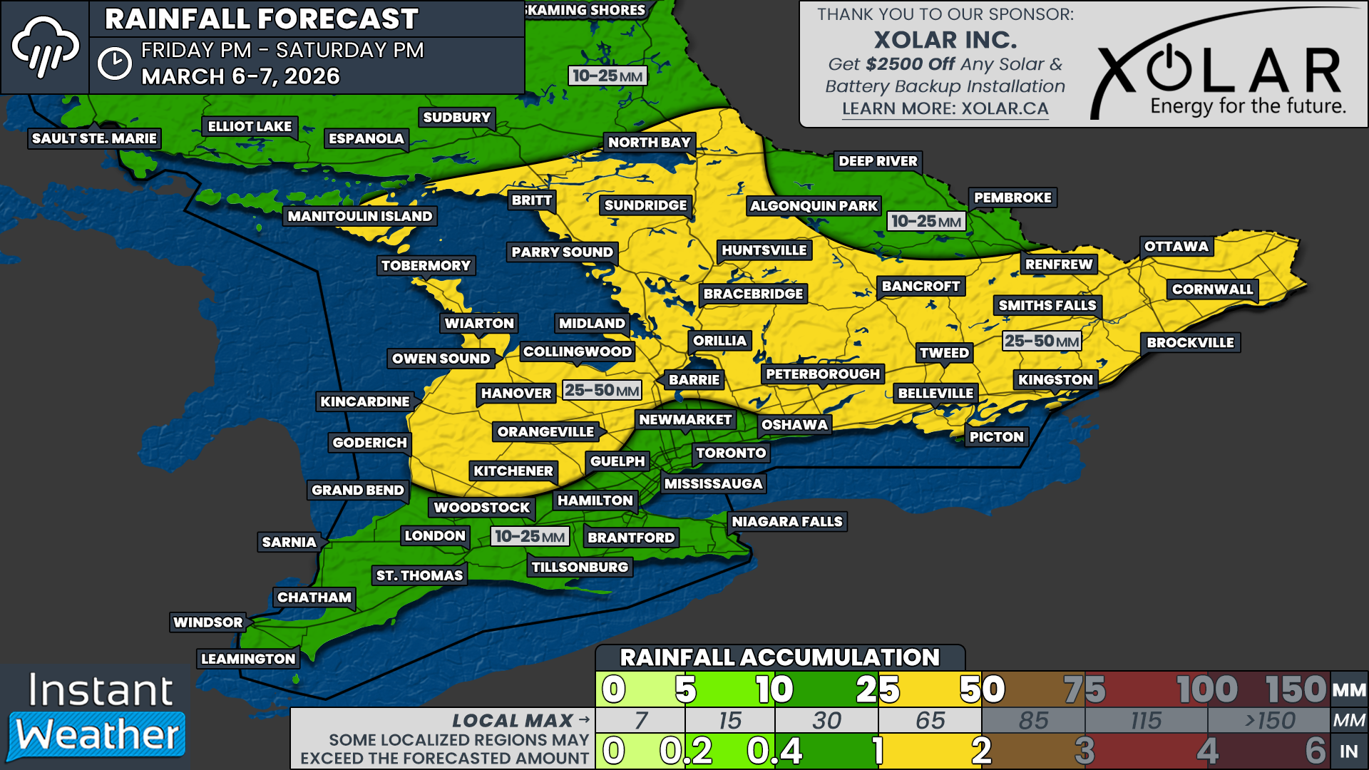
Aside from the thunderstorm threat, heavy rainfall will be a major story with this system. Widespread rainfall totals of 25 to 50 mm are expected across many areas by the end of Saturday.
The heaviest rain is expected to stretch from the Lake Huron shoreline northeastward through Central Ontario and into portions of Eastern Ontario. Most areas within this corridor will likely see around 25 to 40 mm of rainfall, although localized thunderstorms could push totals closer to 50 mm or even as high as 65 mm in isolated locations where storms repeatedly track over the same area.
Deep Southwestern Ontario and parts of the Golden Horseshoe are expected to receive around 10 to 25 mm of rain. However, rainfall totals will be highly variable depending on thunderstorm activity. Some locations could easily exceed 25 mm if stronger storms develop.
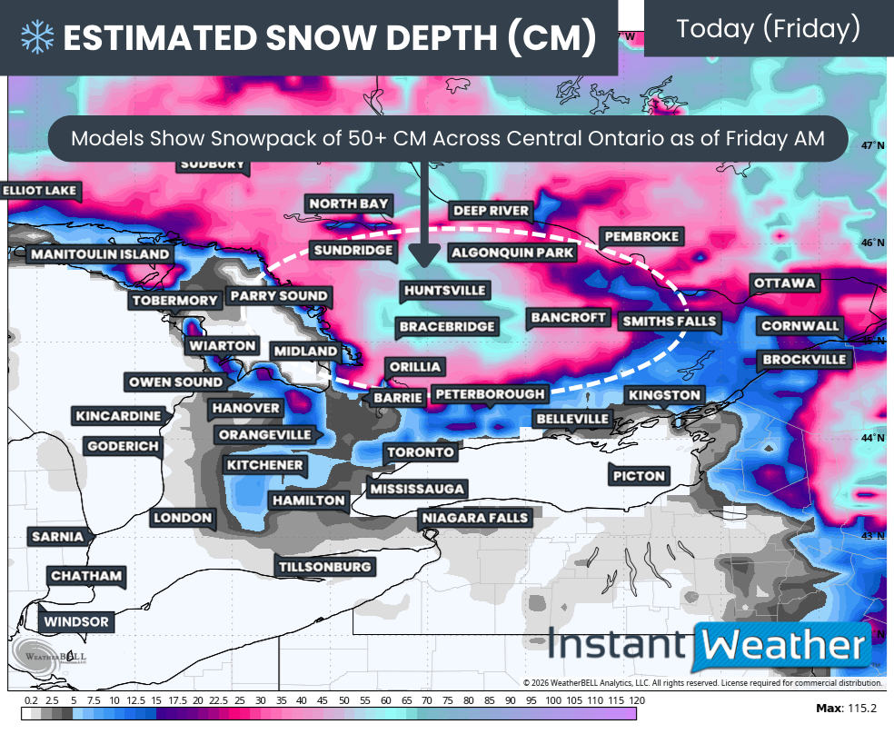
ESTIMATED SNOW DEPTH (CM) - MAP FROM WEATHERBELL
Even without the snowpack, this amount of rainfall would already be somewhat concerning for early March. In some areas, the ground remains partially frozen, which limits its ability to absorb rainfall efficiently and increases the likelihood of runoff.
The additional concern comes from the amount of snow still on the ground in parts of Southern Ontario. Snow depth remains quite significant across many areas, especially in Central Ontario.
Model estimates indicate that the deepest snowpack is currently located across Muskoka and into Algonquin Park. However, this is only an estimate. Given the amount of lake effect snow that some of these regions received this winter, the true depth may not be fully captured in the model data.
Current estimates suggest snow depths of roughly 50 to 100 cm in the deepest locations. That represents a large amount of stored water that will eventually enter local rivers and streams as melting begins.
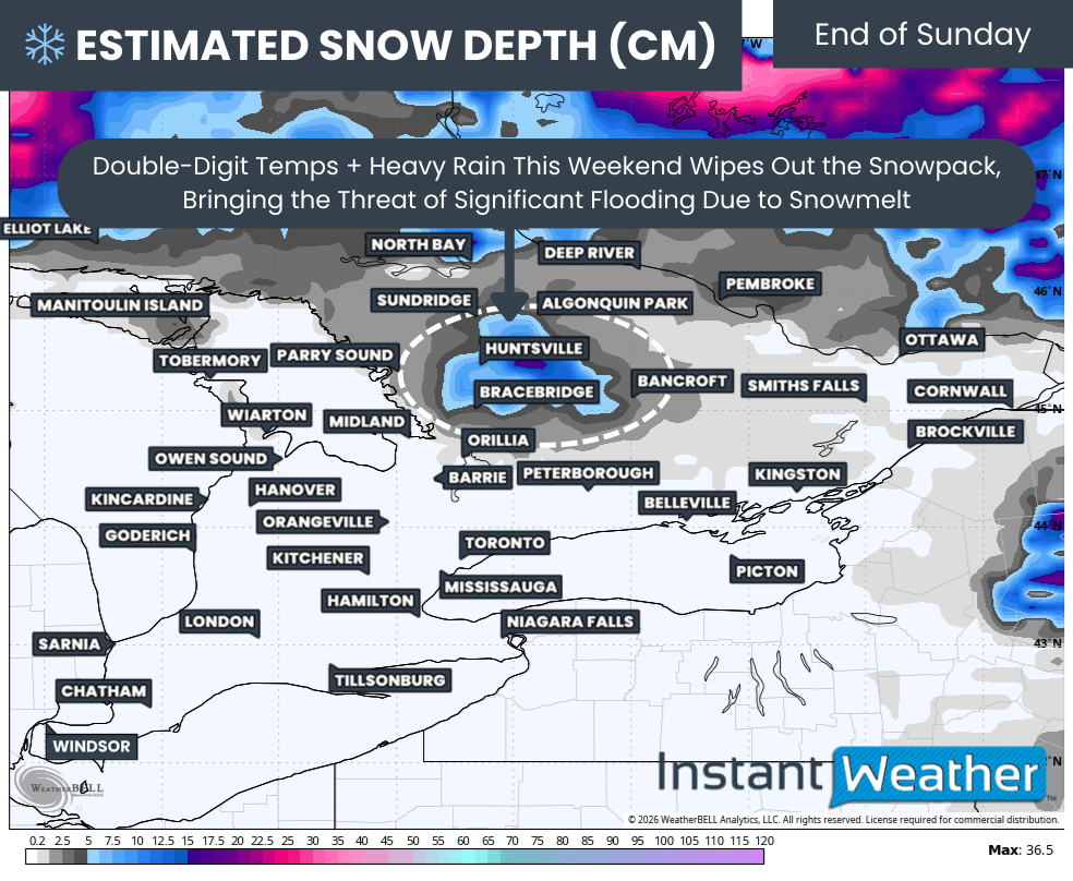
ESTIMATED SNOW DEPTH (CM) - MAP FROM WEATHERBELL
With temperatures climbing well into the double digits on Saturday across much of Southern Ontario, including parts of Central and Eastern Ontario, the snowpack is expected to begin melting rapidly. When combined with 25 to 50 mm of rainfall, this could lead to a fairly rapid influx of water into the watershed.
Forecast models disagree somewhat on how quickly the snowpack will melt. The European model is slightly less aggressive with melting, while the American model shows a much more dramatic reduction in snow depth over the weekend.
According to the American model scenario, most of the snowpack across Southern Ontario could largely disappear by the end of Sunday. The only remaining snow would likely be confined to a small pocket around Muskoka with roughly 5 to 20 cm still on the ground.
If this scenario verifies, it would mean that a large portion of Southern Ontario’s snowpack could melt and enter the watershed within about 48 hours. That would represent a significant amount of water moving through the system in a relatively short period of time.
Residents in flood-prone areas, particularly those located near rivers and streams that commonly experience spring flooding, should be prepared for the possibility of rising water levels over the coming week. This concern is especially relevant across Central and Eastern Ontario, where much of the deeper snowpack is located.
NOTE: YOU CAN CLICK ON THE MAP TO OPEN A ZOOMABLE IMAGE
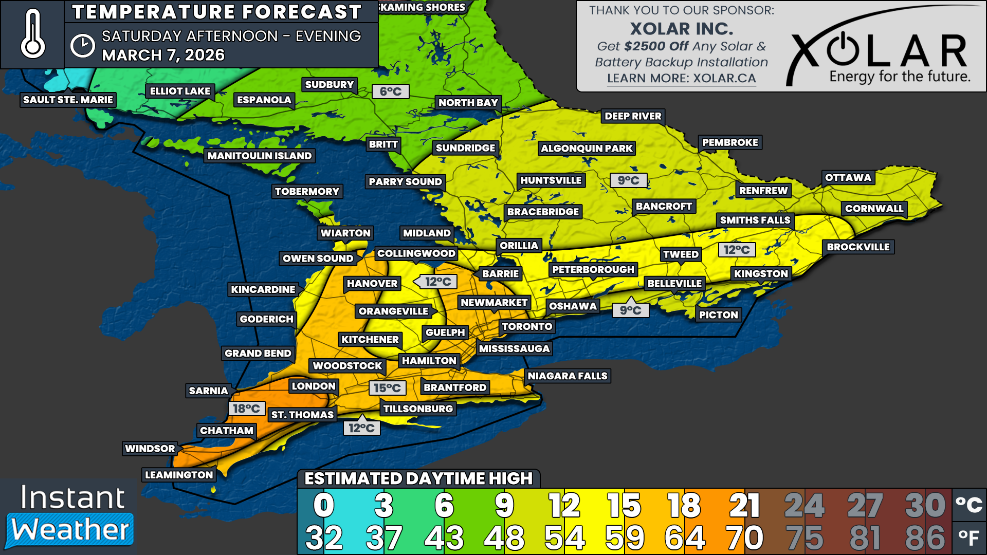
In terms of temperatures, the warmest air is expected to arrive on Saturday. Daytime highs will climb well into the double digits by late morning and afternoon across most of Southern Ontario. For many locations, this will likely be the warmest day experienced so far in 2026.
The warmest conditions will likely occur across Deep Southwestern Ontario, including Windsor, Sarnia and Chatham. Current data support temperatures reaching the upper teens and possibly even approaching the 20°C mark for the first time this year. It is still somewhat uncertain whether temperatures will reach that milestone, but if it happens, the Windsor area would be the most likely location.
Across the rest of Southwestern Ontario and into the Golden Horseshoe, daytime highs are expected to reach the mid to upper teens. Areas closer to the shorelines of the Great Lakes, along with higher elevations northwest of the Greater Toronto Area, may end up slightly cooler with highs closer to 12 to 15°C.
Double-digit temperatures should also extend into Central and Eastern Ontario. Highs around 12 to 15°C are expected from Lake Simcoe through Peterborough and into Brockville.
Areas directly along the Lake Ontario shoreline from Oshawa to Kingston will likely remain slightly cooler with daytime highs around 9 to 12°C due to the influence of the cold lake waters.
Across the rest of Central Ontario and Eastern Ontario, including the Ottawa Valley, temperatures are expected to reach the high single digits or low teens, with most areas topping out around 9 to 12°C.
A brief cooldown will arrive late Saturday night as colder air moves back into the region. Overnight lows will fall back near the freezing mark or into the low single digits. Daytime highs on Sunday will struggle to climb out of the single digits for many locations.
However, this cooldown will be short-lived. Double-digit temperatures are expected to return again on Monday, Tuesday and possibly Wednesday as the active weather pattern continues.