Significant Winter Storm to Hammer Parts of Southwestern and Central Ontario With Up to 50cm of Snow and Blizzard Conditions on Tuesday and Wednesday

After the first day of this multi-day winter storm, most saw just heavy rainfall with minimal impact as the rain begin to transition over the wet snow towards the afternoon and continuing this evening. Current radar as of early Monday evening suggests that most areas except for Eastern Ontario and around the Lake Ontario shoreline has switched over to snow with some accumulation possible by midnight in some areas. Those the haven’t already switched over mainly through the GTA will see wet snow beginning to mix in overnight with accumulation by the time you wake up in the morning.

The exact impact of this storm will be very location-dependent as the stalled out low-pressure system won’t have much moisture to work with by itself but that’s where the lakes will come into play and add some extra fuel to this storm. Hence it’s better to think of this storm as a snow squall event because the lake enhancement will act similarly to the lake effect bands we see where one location can get pounded with extreme snowfall totals while just down the road receives a dusting of snow.

General snowfall totals for the locations that have little lake enchantment will range from around 10-20cm with lower amounts through the GTA and out in Eastern Ontario where more rain will reduce the snow totals. While on the other hand, those very localized zones south of Georgian Bay and southeast of Lake Huron could easily double those non-lake enhanced totals with the potential for 30-50cm and perhaps over 50cm around the Blue Mountains.

We expect heavy snow to develop through Southwestern Ontario beginning just after midnight with strong wind gusts around Lake Huron and Georgian Bay between 40-70km/h. This will create blowing snow and localized blizzard conditions throughout the morning and afternoon in the London, Barrie, Collingwood and Grey-Bruce area. We should mention that this is a very localized event and our timeline graphic isn’t designed for that. For example, London will likely see blizzard conditions so we’ve included that in the graphic but Brantford won’t. It’s highly recommended that you download our app HERE and check out the hourly forecast for the most accurate information for your specific location.

The heavy snow will continue through most of the afternoon on Tuesday although it will likely become lighter later in the day and into the evening. Blizzard conditions will also come to an end later in the afternoon as wind gusts will subside just after the noon hour (later afternoon for the London area). Eastern Ontario will see rainfall throughout the day on Tuesday with some wet snow mixing in through the higher elevations around Bancroft and Peterborough during the afternoon. The Ottawa and Kingston area won’t see any flakes until late Tuesday with little to no accumulation expected.

Snowfall will continue overnight into Wednesday but it will become increasingly dependent on the lake enhancement so we’ll see some traditional snow squalls and lake effect snow develop around Lake Huron and Georgian Bay early Wednesday morning. This could affect the Barrie/Orillia and Northern GTA area during the Wednesday morning commute especially the Hwy 400 corridor between Newmarket and Barrie. However it will disipate later in the morning and early afternoon as the lake effect snow machine is turned off.

The theme throughout this forecast has been location location location and that will continue to be the story as we take a look at the potential snowfall totals by Wednesday. Our last forecast broke down the snowfall totals by each day so this forecast map will likely look different from our previous Tuesday’s snowfall forecast for your location. This is because we’ve added on Wednesday’s totals to Tuesday as Wednesday in itself isn’t very significant but could add an extra 10-15cm around the snowbelts mainly around Georgian Bay.

The real winners (or losers depending on if you like snow) of this storm will easily be just south of Georgian Bay through parts of Bruce-Grey counties including Meaford and the higher elevations southwest of Collingwood with snowfall totals over 50cm. Surrounding regions including Collingwood, Wiarton and Chatsworth can expect to pick up between 30-50cm with lower totals near the shoreline.

Another area that will be pummeled by the lake enhancement with be to the southeast of Lake Huron just west of the City of London. Locations such as Lambton Shores, Strathroy and Parkhill could also see between 30-50cm. The City of London, along the Lake Huron shoreline and into Simcoe County (Barrie, Midland etc.) will see some impact from the lake enhancement with totals around 20-30cm. Further north, North Bay and the Algonquin Highlands area may also see as much as 30cm.

The rest of Southwestern and Central Ontario including Kitchener/Waterloo, Windsor and Muskoka will see little lake enhancement but still the light to moderate snowfall throughout Tuesday and into Wednesday will add up. General totals outside of the snowbelts will range from 10-20cm with closer to 5-10cm through the GTA and Niagra region with more a rain/snow mix expected. Eastern Ontario will again be largely unaffected with just rainfall during the day on Tuesday and some wet snow later in the day.

If you need to travel tomorrow or go anywhere please be sure to drive according to the conditions and leave plenty of time to get to your destination. This is especially true through the areas the could see blizzard conditions where road closures aren’t out of the question so consider avoiding non-essential travel if you can (although we are in the middle of a pandemic so that’s a good idea regardless of the weather conditions).

Multi-Day Winter Storm to Affect Southern Ontario Starting Monday With Heavy Snow and Rain; Blizzard Conditions Possible in Some Areas on Tuesday

As we’ve been covering over the past few days, a prolonged winter storm is expected to move into Southern Ontario during the final days of November. This storm is quite a nightmare to forecast as we have so many variables to deal with including temperatures, precipitation type, intensity and lake enhancement just to mention a few. That means we have a lot of information and maps contained in this forecast which will hopefully help you plan your activities in the coming days.

TIMING

We’ll start with Monday morning as the system begins to enter the province starting with Southwestern Ontario during the mid-morning hours and spreading across the rest of the region throughout the late morning. For almost everyone, it will start as rain for at least the first few hours with temperatures several degrees above the freezing mark. Colder air will slowly move in from the west starting first with the Windsor/Sarnia area around 8-9 AM as the rain transitions over to snow towards the later morning hours. This transition will occur next for the Goderich and Grey-Bruce region around the noon hour beginning with the Bruce Peninsula and spreading along the Lake Huron shoreline.

As we head into the afternoon, more areas away from the Lake Ontario shoreline will begin to mix in some wet snow with a few hours of heavy snow later in the afternoon. This includes much of Central and Southwestern Ontario especially around the southern Georgian Bay shoreline due to some lake enhancement. For the GTA and Niagara region, the rain will continue into the dinner hour before it begins to switch over to snow as the colder air builds in just in time for the evening rush hour. Expect some messy road conditions for the evening so be sure to travel with caution. Rainfall will begin during the late morning hours for Eastern Ontario and continue throughout the day heavy at times. Some snow will mix in through the higher elevations later in the afternoon including Bancroft and Pembroke but most of Eastern Ontario should stay all rain into Tuesday.

ACCUMULATION

For this event, we’ve decided it is best to break the snowfall down by each day. Although it should be mentioned that total accumulation over the 3 days could exceed 30-50cm especially around the Southern shoreline of Georgian Bay. The heaviest snowfall accumulation by the end of the day on Monday is expected to be found in the higher elevations near the Quebec border including Algonquin Park, Bancroft and Barry’s Bay along with a small zone just south of Georgian Bay that includes Wiarton, Meaford and Collingwood. These areas could see as much as 12-20cm by midnight (however snow won’t end at midnight and the additional accumulation will be included in Tuesday’s forecast) with locally as much as 25cm. Outside of this area, the forecast becomes very tricky because it’s very temperature-dependent and models are still disagreeing on the exact accumulation.

Our forecast assumes no melting occurs which is pretty unrealistic given that temperatures will still be above the freezing mark when the switch over occurs so consider this the max possible accumulation - some areas will likely get much less than forecast. With that being said, the rest of Southwestern Ontario into parts of Central Ontario including Windsor, London, K/W, Barrie and Muskoka have the potential to see between 6-12cm of accumulation. Less than 6cm is expected directly east of Georgian Bay and through the Northern GTA away from the lakeshore. Downtown Toronto and the Niagra region will likely see little to no accumulation by the end of Monday only switching over the wet snow during the evening.

For those that don’t see the snowfall accumulation, you won’t exactly be spared with this system but it will come down as heavy rainfall instead. Rainfall totals for Eastern Ontario into the GTA/Niagara region will range from 20-30mm by Tuesday (we didn’t break this down by day because most of the rain will come on Monday). This is actually a fair amount of rain for this time of the year so there could be some localized flooding in low-lying areas especially since the rain will come down heavy at times. The rest of Southern Ontario can expect between 10-20mm of rainfall before switching over to snow with less than 10mm through Windsor, regions east of Lake Huron and into the higher elevations Central Ontario where less rain is expected before the switch over occurs.

As we move into Tuesday you might be thinking that this storm was more bark than bite but remember this isn’t a typical storm that is contained to a 12-24 timeframe - this will be a multi-day event. That will quickly become apparent as you wake up Tuesday morning and throughout the day as the story shifts from the messy mix that we saw on Monday towards heavy lake enhanced snow and blizzard conditions in some areas with strong gusty winds. As the low-pressure system begins to stall out over the region it will seem like a never-ending flow of moisture as bands of snow circulate the stalled-out system.

In general, the bands won’t be very strong with some light snow for most areas but the problem is that colder air will allow the lakes mainly Georgian Bay and Lake Huron to increase the snowfall rates for some surrounding regions. Current data suggests those regions will include the Bruce Peninsula through the southern shoreline of Georgian Bay like Meaford and Collingwood and another zone southeast of Lake Huron just to the west of London. These areas may see between 20-30cm of snowfall accumulation by the end of Tuesday will locally higher amounts. Strong wind gusts between 40-70km/h will also present a big issue combined with the heavy snowfall early Tuesday which may result in some blowing snow and localized blizzard-like conditions around Lake Huron and Georgian Bay. Wind gusts will subside later in the day on Tuesday.

The remaining regions around Lake Huron and Georgian Bay can expect as much as 12-20cm with lesser amounts further inland with around 6-12cm for the rest of Southwestern and Central Ontario. Near the Lake Ontario shoreline, there will still be some rain continuing early Tuesday morning so total snowfall accumulation will be lower around 2-6cm. Little to no accumulation is expected for Eastern Ontario. It’s important to mention that this isn’t a final forecast for Tuesday as we’re dealing with lake-related snowfall which is very tricky to pin down. If needed, we’ll have an updated snowfall map for Tuesday posted sometime Monday. Snowfall will also continue into Wednesday which we’ll have a separate forecast for that as we get closer and more certain on what will happen.

Complex Prolonged Winter Storm Takes Aim at Southern Ontario to Start Off December; Up to 20–40cm of Snow Possible by Wednesday

DISCLAIMER: This is a very preliminary forecast for a complex winter storm over 3 days. It is subject to change as we get closer to the event and the situation evolves. We’ll have a full detailed forecast for Monday and a preview of Tuesday’s forecast out sometime Sunday afternoon or evening - including our regional timeline graphic.

It might have been a slow start to the wintery weather across Southern Ontario after we saw the season’s first significant snowfall (for most areas) last week, but Mother Nature is wasting no time! A very difficult forecast is ahead for Southern Ontario as we say goodbye to November and hello to December with an approaching low-pressure system that is expected to intensify as it moves into the Great Lakes region. The precipitation will start sometime Monday morning or afternoon depending on the location. The usual complexity this time of the year which is dealing with the freezing line and determining who sees rain and who sees heavy snow will certainly exist for this system. But there is an additional layer of uncertainty with this system as we expect it will stall out somewhere over our region and continue to pump moisture through Tuesday and into Wednesday. As we head into Tuesday, colder air will start to flow into the province which will allow the lakes particularly around Lake Huron and Georgian Bay to enhance the system and add even more moisture.

With that being said, the best approach to a multi-day storm like this with vastly different conditions day-by-day is to look at the expected impacts on each day. Now, we’ll have a more detailed forecast for each day later on but at this point, we can provide a broad look at each day.

MONDAY

Precipitation will start to affect Southern Ontario sometime during the late morning or early afternoon hours on Monday. The exact precipitation type is a little uncertain but it’s a fair bet that most areas will start with some rain as temperatures are hovering several degrees above the freezing mark. Later in the day on Monday, we’ll see colder air slowly begin to invade from the west causing the rain to switch over to some moderate to heavy snowfall through much of Southwestern and Central Ontario especially in the higher elevations around the Dundalk Highlands. This includes Windsor, Kitchener/Waterloo, York Region and the Barrie/Muskoka area. Heavy precipitation will continue through the evening with the mixing line extending from around Hamilton to the northeast away from the Lake Ontario shoreline to Peterborough and up into the Pembroke area. Those around the Lake Ontario shoreline and into Eastern Ontario will continue to see heavy rainfall past midnight and overnight into Tuesday.

Tuesday

As we head into Tuesday morning we’ll see the system begin to stall out and the heaviest precipitation bands will move out over Quebec but less intense bands will rotate back in. Light rainfall will be ongoing through Eastern Ontario and light to moderate snowfall for the rest of Southern Ontario. We do expect some lake enhancement around Lake Huron and Georgian Bay to develop as the precipitation associated with the system wraps back around. This will result in locally heavier snowfall particularly east of Lake Huron and Georgian Bay throughout the day on Tuesday and into early Wednesday.

Wednesday

Wednesday morning is where we have the biggest amount of uncertainty as we believe the low-pressure system that was stalled out over our region for over 24 hours will begin to move out. While it’s moving out there are some indications that it could rapidly intensify yet again over Quebec just after midnight. Depending on when and where this happens it could wrap in some heavy bands of snow that may affect Central Ontario (especially around the Quebec border around North Bay) with intense snowfall during the early morning hours on Wednesday. Some of the latest data suggest this occurs as the low pressure is further north into Quebec which would have less of an effect on our region. We’ll be watching this one closely and have a better idea as we see what happens as the system moves into our area.

Putting together the potential accumulation over the three days, some areas may see between 15-30cm of snowfall accumulation or even more by Wednesday. We should note however that this is over three days so there is a big difference in the impacts of a storm that brings this amount of snow in 12-24 hours vs. over a 72 hour period. Also, some of the snow will be coming down onto ground that is quite wet after earlier rainfall so it may take a few hours until the snow begins to accumulate which would throw off the data we base our forecast on. Those in Eastern Ontario are expected to see little snowfall accumulation but could see a fair amount of rain with totals between 15-30mm by Wednesday. As we mentioned above, there’s still lots of uncertainty so take any accumulation amounts with a grain of salt. We’ve decided to put this map out to give you a rough idea of potential impacts but it’s far from a final forecast. Check back in the coming days for more detailed information as we get a better handle on what will happen.

More Wintery Weather on the Way for Southern Ontario Starting Tuesday Evening; 6–12cm of Snowfall Accumulation Possible in Some Areas by Wednesday

TIP: You can click on the image to open it in a new tab and be able to zoom into the map.

TIP: You can click on the image to open it in a new tab and be able to zoom into the map.

Another messy winter system is expected to affect Southern Ontario starting Tuesday evening and lasting throughout the day on Wednesday. However, the exact impacts will be extremely location dependent with heavy accumulating snowfall possible across Central and Eastern Ontario or a mixed bag of wet snow/rain through Southwestern Ontario and around the Golden Horseshoe. Total accumulation through the hardest-hit areas mainly away from the lakes including locations like Barrie, Muskoka, Peterborough and the Ottawa Valley will generally range from 6-12cm by Wednesday afternoon. A few localized areas may pick up as much as 15cm particularly around the Haliburton, Bancroft and Pembroke area.

As far as timing, we’ve put together a graphic for regions across Southern Ontario showing a rough idea of what to expect. This is only an estimate though and the exact precipitation and timing may vary by a few hours. Download our app HERE and check out the latest up to date hourly forecast for your exact location.

TIP: You can click on the image to open it in a new tab and be able to zoom into the graphic.

TIP: You can click on the image to open it in a new tab and be able to zoom into the graphic.

Precipitation has already begun to affect Extreme Southwestern Ontario with the Windsor and Sarnia area staying out of the wintery mix with some rain showers ending late this evening and picking back up Wednesday morning. Those along the Lake Huron shoreline like Goderich have already started to see some wet flurries and that will continue for the rest of Tuesday with some heavier snow just before midnight and transition over the rain early Wednesday morning. London and surrounding regions will start with some mixed precipitation this evening and transition over to rain around the midnight hour with a few hours of dryness and picking back up late Wednesday morning. A similar story will unfold across the Golden Horseshoe with wet snow mixed with rain tonight before tapering off early Wednesday morning and returning as rain in the afternoon.

The biggest impact will be through Central Ontario including Barrie, Muskoka and Peterborough with snow starting late tonight and becoming more intense during the overnight. Temperatures are expected to rise just after sunrise on Wednesday so we’ll start to see some rain mixing in during the late morning and transitioning over to rain around noon. For those in Eastern Ontario, you will also get some snow but it will start a few hours later between 1-3 am with heavy snow affecting the morning commute in this area. Rain will start to mix in around Lake Ontario and the St. Lawerence River during the late morning but limited rain is expected to make it into the Ottawa area before precipitation tapers off around in the afternoon.

There will be another round of precipitation through the rest of Wednesday and into the overnight hours but it should be all rain with temperatures across Southern Ontario above the freezing mark. However, this could cause some slushy road conditions with the rain mixing with the previous snowfall.

Accumulation for most areas will range from 6-12cm (likely closer to the lower end of the range) with the potential for around 15cm in localized higher elevations through Central and Eastern Ontario. Lower totals further south including the Northern GTA, K/W and Kingston area with between 2-6cm are expected. Little to no accumulation will be found along the Lake Ontario shoreline into London, Sarnia and Hamilton with some wet snow but likely won’t stick. Windsor will be unaffected by the snow with precipitation coming down as all rain.

First Snowstorm of the Season Targeting Southern Ontario on Sunday With Up to 20cm of Snow Possible by Monday Morning

TIP: You can click on the image to open it in a new tab and be able to zoom into the map.

TIP: You can click on the image to open it in a new tab and be able to zoom into the map.

Usually, by now most of Southern Ontario would’ve experienced a significant snowfall event as we head into the middle of November. That isn’t true this year though as aside from regions in the snowbelts, we haven’t really seen much snow which is a result of the fairly mild fall that we’ve had this year with many areas still experiencing double-digit temperatures even into November.

Unfortunately, all good things (that is if you don’t like snow) must come to an end and it’s going to be quite the jump from early fall-like weather to something we would see in early December beginning early Sunday. That shift in the weather is courtesy of a system that is expected to move into the region Sunday morning and lasting throughout the day and into Monday morning. For most areas, it will bring the season’s first significant snowfall including much of Southwestern, Central and Eastern Ontario and parts of the GTA that are away from the lakeshore. There is the potential for as much as 12-20cm of total snowfall accumulation by the time the storm moves out of the area on Monday morning.

STORM TIMING

TIP: You can click on the image to open it in a new tab and be able to zoom into the graphic.

TIP: You can click on the image to open it in a new tab and be able to zoom into the graphic.

TIP: You can click on the image to open it in a new tab and be able to zoom into the graphic.

TIP: You can click on the image to open it in a new tab and be able to zoom into the graphic.

With the first significant winter storm ahead of us for Southern Ontario, we thought this would be a good time to launch some new graphics we’ve been working on over the past few months. One of the most frequent questions we get is usually about timing for a specific location or region so we’ve broken down the province into 12 zones and outlined the precipitation timing hour by hour to help you better plan out your day. Obviously, it won’t be perfect as the forecast can change but hopefully, it’ll give you a rough idea of what to expect for your area - we tried our best to cover all the major population centres so if you can’t find your location just focus on the city on the graphic that is closest to you. Let us know what you think of the new graphic!

Back to the forecast, precipitation will begin to enter the region from south of Lake Erie beginning early Sunday morning around 7-8 am. The first areas to be affected will be the Windsor and Sarnia region starting with a rain/snow mix and transitioning to heavy snow later in the morning and into the afternoon. Snow will continue to spread to the northeast throughout the day on Sunday reaching the GTA and KW area by late morning. Those right near the lakeshore particularly around Lake Ontario and Erie will likely see rain or a mix of rain/snow due to temperatures being slightly warmer. The snow will intensify further during the afternoon as it spreads further north reaching Central and Eastern Ontario just after the noon hour. This is except for the Ottawa Valley into Renfrew which won’t see the first flakes until around 4-5 pm.

Precipitation will continue mostly in the form of moderate to heavy snowfall into the evening as we being to see it taper off in Extreme Southwestern Ontario and some rain mixing back in through the Hamilton/Niagra region. In Eastern Ontario, there is the threat of a few hours of freezing rain between 10 pm - 2 am including Kingston and Brockville (Ottawa may see an hour or two but it should remain mostly snow). The system will begin to exit our region early Monday morning with precipitation coming to an end just after midnight for most areas (Eastern Ontario will continue to see heavy snowfall into the mid-morning hours).

SNOWFALL TOTALS

TIP: You can click on the image to open it in a new tab and be able to zoom into the map.

TIP: You can click on the image to open it in a new tab and be able to zoom into the map.

TIP: You can click on the image to open it in a new tab and be able to zoom into the map.

TIP: You can click on the image to open it in a new tab and be able to zoom into the map.

Now onto the tricky part of the forecast which is the expected snowfall accumulation from this system. While we’re fairly confident in the timing and track of this system the problem is where the temperature will end up during the day on Sunday and into the evening. Most models seem to suggest that areas away from the lakeshore should stay below the freezing mark throughout most of the day which would be favourable for significant snowfall accumulation. This zone extends from the Quebec border through the Kawartha Lakes and into parts of Southwestern Ontario and the northern GTA. So areas like Renfrew, Ottawa, Peterborough, Newmarket, Guelph and Kitchener/Waterloo will likely see total accumulation between 12-20cm.

The accumulation will drop off the further to the northwest you go due to the majority of the moisture being focused on those east and south of Lake Simcoe. Areas such as Barrie, Orillia and Muskoka can expect as much as 5-10cm and even less through the Bruce Peninsula and Parry Sound/North Bay.

The tricky spot is along the shoreline of Lake Erie and Ontario and those out in Eastern Ontario along the international border where some models suggest that rain or even freezing rain could mix in at times. This would reduce the potential snowfall accumulation and melt any snow that has already accumulated. We have decided to put Hamilton, Toronto, Kingston and Brockville in the 2-6cm total snowfall accumulation zone but it could easily end up much higher should less rain mix in. It’s important to mention that this area has the potential to overachieve the forecast by a big margin should it remain all snow as the moisture is there (some models have as much as 20cm through the GTA even near the lakeshore but this is unlikely). Overall, the further inland you are, the greater the chance that you see over 10cm of snowfall accumulation.

We’ll continue to monitor the latest data and issue any updated forecasts if necessary.

Plunge Into Winter After Record-Breaking Wind Storm; Snow Squalls East of Georgian Bay & Lake Huron to Bring Up to 15cm on Monday

As the wind storm that Brough wind gusts up to 120-140km/h to some parts of Southern Ontario winds down, the active weather doesn’t end for those in the typical snowbelts. This is a result of colder air flowing in behind the system that brought us the wind storm causing lake effect snow to develop off mainly Georgian Bay although scattered flurries may also affect regions east of Lake Huron. We’re already seeing some development off the lakes Sunday evening although it’s fairly disorganized and mostly coming down as rain. It will change as we head into the overnight and through Monday as temperatures drop and the bands become more organized.

We’re expecting two main bands to develop off Georgian Bay early Monday morning with one stretching from Britt and inland through Burk’s Falls/Kearney. The other band will cut across the northern tip of the Bruce Peninsula and inland through South Muskoka affecting locations like Port Carling, Bracebridge and Haliburton. The band will be quite relentless locking into those areas all day Monday and not weakening until late in the evening. Now, it’s important to mention that temperatures will likely be slightly above the freezing mark for most areas so while snow will be falling it might not easily accumulate. The heavy wet snow will certainly make for hazardous driving conditions due to near-zero visibility through the affected region. Be sure to drive according to the conditions and leave plenty of time to get to your destination.

As far as accumulation, this is a tricky one because as we said, some of the snow could melt on contact due to the above freezing temperatures. This would reduce the expected accumulation somewhat although at some point the snow will begin to accumulate. We believe there are two zones including Burk’s Falls, Kearney, Port Carling, Bracebridge and Haliburton that could see as much as 12-20cm (it will likely be closer to the lower end of that range) by the end of Monday.

Surrounding regions including Sprucedale, Gravenhurst, Tobermory and the higher elevations south of Georgian Bay (Meaford. Flesherton etc.) have the potential to see between 6-12cm of snowfall accumulation. The rest of the regions east of Georgian Bay and away from the shoreline east of Lake Huron can expect between 2-6cm of accumulation. Almost all of Southern Ontario can expect to see a few flurries sometime during the day on Monday but there will be little to no accumulation outside of the snowbelts.

The threat of snow squall activity won’t end Monday night though! We’ll see the squalls weaken substantially late Monday as the wind direction shifts causing the remaining weakened squall to move southward through northern Simcoe County. This is why we have the Orillia and Midland region picking up between 2-6cm which will mostly come during the evening. Squalls could redevelop again Tuesday morning but will affect regions south of Georgian Bay and northeast of Lake Huron (Kincardine, Owen Sound etc.). We’ll continue to monitor that and issue a forecast if necessary.

Powerful Wind Storm Targeting Southern Ontario on Sunday With Wind Gusts Up to 115km/h Around the Great Lakes

After what has been quite a mild week with multiple days of record-breaking warm temperatures, it’s back to reality for Southern Ontario. We’ve seen more seasonal temperatures for this time of the year with daytime highs in the single digits and overnight lows dipping below the freezing mark over the past few days. Now, we’re monitoring a potent classic fall system that will affect Southern Ontario starting late Saturday and lasting through Sunday.

That storm will come in the form of some heavy rainfall with accumulation from 15-25mm for most areas, but more concerning is the potentially damaging wind gusts that will come with the system. Areas near the shorelines of Georgian Bay, Lake Ontario, Huron and Erie could see wind gusts reaching as high as 100-115km/h during the morning and afternoon hours on Sunday. Further inland, wind gusts will still be quite strong ranging from 80-100km/h. This will likely cause some tree branches to come down and perhaps localized power outages.

The strong winds will begin to pick up in intensity just after midnight into the early hours of Sunday with the most damaging winds expected during the mid to late morning and early afternoon on Sunday. Don’t be surprised to be woken up by the howling winds early Sunday morning especially if you live along the shorelines where the 100+km/h gusts are expected. Also, make sure to bring in anything that might blow away (ie. holiday decorations).

The hardest-hit region will be the aforementioned shorelines around the Great Lakes specifically locations such as Prince Edward County, Port Colburne, Grand Bend, Goderich and Kincardine. Expect wind gusts over 90km/h here with the potential to go as high as 115km/h (especially the northeastern Lake Erie shoreline). Also should be mentioned that these strong winds could cause some issues in areas prone to flooding from storm surge so flooding is possible. Surrounding regions including those around Georgian Bay such as Parry Sound, Leamington, Oshawa, Belleville, Kingston, Collingwood and Midland will also see wind gusts over 90km/h but should stay below 100km/h for the most part. Refer to the zoomed-in maps below for the information specific to your location. The rest of Southern Ontario (except for northern parts of Eastern Ontario) can expect wind gusts ranging from 80-90km/h with a few localized areas exceeding 90km/h. Those in the northern part of Eastern Ontario including the Ottawa Valley will see wind gusts between 70-80km/h.

The wind gusts will begin to die down as we head into Sunday evening with the lingering rainfall from the system transitioning over to wet snow as colder air floods in behind the exiting system. This will set the stage for the potential for lake effect snow next week that may bring significant snowfall to the typical snowbelts around Lake Huron and Georgian Bay. It’s unclear on who exactly could see the heaviest accumulation as we’re still several days away so stay tuned for a more detailed forecast on that in the coming days.

Blizzard Near Miss for Southern Manitoba; Risk of Prolonged Freezing Rain Sunday Through Monday

We’ve been closely monitoring a system that is expected to affect the Prairies this weekend over the past few days. Models have shifted around and at one point it looked like Southern Manitoba could’ve been dealing with a historic blizzard. Fortunately, that doesn’t appear possible with the latest data but what we will be dealing with instead is a risk of prolonged freezing rain starting early Sunday morning. The focus of the freezing rain threat will be on Southwestern Manitoba including Virden, Roblin, Dauphin and Swan River where up to 12-16 hours of constant freezing rain is possible. We could see fairly extensive ice accretion on untreated surfaced in these areas including rural roads, sidewalks, tree branches and power lines so expect hazardous driving conditions and power outages.

Light freezing drizzle is expected to develop sometime late Saturday into Sunday morning as the system approaches the region. There is some disagreement amongst the models on where the freezing line will be located but it should be somewhere around the Brandon and Neepawa area which means those in Western Manitoba will see some form of freezing precipitation (mainly freezing rain or ice pellets). Southcentral and Southeastern Manitoba including Winnipeg will be well above the freezing mark throughout this event and will see minimal freezing rain if any at all. In fact, during the day on Sunday, it will be quite mild for the Southeastern part of the province with the temperature reaching into the upper teens or perhaps even the low 20s! The temperature gradient throughout the province will be extremely tight so while Winnipeg basks in late summer-like temperatures, Brandon and Southwestern Manitoba will struggle to get above the freezing mark.

The precipitation will continue to become more intense during the morning hours and into Sunday afternoon. This is when we expect the worst conditions with very heavy freezing rain occurring during the afternoon and evening on Sunday. As we mentioned above, the temperature gradient will be very tight so there won’t be much distance between locations that see major impacts from the freezing rain compared to those that warm up enough to switch over to regular rain before the heavier precipitation arrives. This will be very true for locations around the Brandon area because models disagree on the exact temperature and how quickly it will warm up. The consensus is that Brandon will rise above the freezing mark just after the noon hour but if this doesn’t happen quickly enough then they could see way more ice accretion than forecasted.

It looks like the freezing line will stabilize somewhere around Virden through Peguis. Areas north of this will see mainly freezing rain while those to the south could see some freezing rain Sunday morning but will switch over to regular rain as we get into the afternoon. Further north, the storm will bring heavy snowfall to Northern Manitoba including locations such as Flin Flon, Thompson and Port Nelson could be dealing with as much as 30-50cm of snowfall by Monday. Strong winds will also be accompanied by heavy snowfall with blowing snow and blizzard-like conditions likely between Sunday evening and Monday afternoon. Precipitation will begin to taper off early afternoon on Monday although could linger around for the northern part of the province until late Monday evening.

Just a quick mention that while Southern Manitoba is missing a potential blizzard, the same can’t be said for those throughout Saskatchewan. We’re expecting widespread accumulation between 30-50cm for much of Central Saskatchewan by Monday. View our Saskatchewan forecast HERE.

Record-Breaking Blizzard Takes Aim at Saskatchewan This Weekend; Up to 50cm of Snow Possible by Monday

It has been a fairly quiet start to the winter across much of Saskatchewan but that is about to change substantially as we watch the potential for a dangerous blizzard that will affect much of Southern and Central Saskatchewan this weekend. Wind gusts up to 50=75km/h combined with intense snowfall rates will produce blowing snow and causing near-zero visibility out on the roads with the worst conditions expected throughout the day on Sunday.

It’s quite possible that this storm could be a record-breaker with widespread snowfall totals that we haven’t seen in quite a long time. The hardest-hit regions could see as much as 30-50cm of snow over the next few days and that might even be a low estimate. It’s not out of the question that some areas pick up 60 or even 75cm in localized regions. Outside of the heavy snowfall, there is also the potential for several hours of an ice pellet and freezing rain mix in Southeastern Saskatchewan late Sunday into Monday morning which could lead to a light coating of ice on untreated surfaces and icy driving conditions.

We expect the first round of snowfall to begin early Saturday morning with some light to moderate snowfall moving into the Western part of the province from Alberta. This will continue into the day on Saturday but will mainly affect the central part of our regions such as Kindersley, Saskatoon and Prince Albert where the heavier bands of snow will be located. The first round of snow isn’t expected to bring much snowfall to the more southern part of Saskatchewan, but the second round won’t be as forgiving so don’t think it’s over when you see little accumulation by the end of Saturday.

As we head into Sunday morning this is when conditions will really start to deteriorate as we see the main system track into the province and the wind starts to pick up. Very heavy snow will stretch from Southwestern Saskatchewan through the southcentral region (Moose Jaw etc.) and into the Hudson Bay area starting Sunday afternoon. Current indications suggest that those in the southeastern corner of the province including Regina, Weyburn and Yorkton could start with a few hours of ice pellets or freezing rain into Sunday evening although it’ll begin to transition over to heavy snow from west to east.

By Sunday evening, conditions will be downright dangerous with snowfall rapidly accumulating combined with strong wind gusts through Southern Saskatchewan. We will likely see some highway closures due to the blowing snow and whiteout conditions so if possible, consider staying home until conditions improve on Monday. The system will begin to taper off during the early morning hours on Monday as it moves off into Northern Manitoba and should be fully done by the noon hour.

When it comes to total snowfall accumulation by Monday, there will be a wide swath from Shaunavon, Moose Jaw, Saskatoon and Hudson Bay that picks up generally between 30-50cm of snow. As we mentioned above, the potential for some areas to overachieve that forecast and see as much as 60-75cm is there. Now, the next zone that includes the Regina area is tricky to forecast given that they’ll initially start with some ice pellets. How fast the ice pellets turn over to snow will determine exactly how much snowfall that region receives. At this point, we believe it will hold the totals below the 30cm mark for Regina so we have them in the 20-30cm zone but if they switch over quicker than expected then up to 40cm isn’t out of the question for them.

Snow totals will be lower the further north you go due to the lack of precipitation and towards the southeast corner of the province where freezing rain will be the more predominant precipitation type. On the topic of freezing rain, several hours of freezing rain which could be heavy at times is expected through the Estevan and Moosomin area during the afternoon and evening on Sunday. Up to 3-6mm of ice accretion is possible in this area which combined with the strong wind gusts could bring down tree branches and cause localized power outages along with icy roads.

Major Snowstorm on the Horizon for Southern Alberta This Weekend; Blizzard Conditions and Up to 30–50cm of Snow Possible

Winter is getting well underway across Alberta and that will continue to be true as we head into a very active weekend with multiple rounds of snowfall blasting parts of Southern Alberta. The worst conditions are expected late Saturday into Sunday as a strong low-pressure system tracks into Saskatchewan with very heavy snow recaching into Southern Alberta. Wind gusts between 50-75km/h are also expected to develop at the same time which no doubt will create hazardous driving conditions out on the roads due to blowing snow. The criteria for a blizzard may be reached in areas such as Lethbridge, Taber, Brooks and Medicine Hat creating whiteout conditions. When all is said and done, we’re looking at as much as 30-50cm of snowfall accumulation by Monday in the above-mentioned regions with local amounts potentially exceeding 50cm in the higher elevations around the Pincher Creek and Cardston area.

Wet snowfall mixed with rain has already started to affect areas near the International border and that is expected to linger into Saturday as temperatures hover a few degrees above the freezing mark. At this point, accumulation will be fairly light given that it will be wet snow and most of it will melt on contact. The exception to this is the higher elevations southwest of Lethbridge that are already near the freezing mark and is expected to remain that way throughout the weekend. Further to the north, the Edmonton and Lloydminster area will see moderate snowfall during the day on Saturday from this first round and the temperature will be several degrees below the freezing mark so it should have no problem accumulating. We expect this first round of snow to move off into Central Saskatchewan sometime during the evening hours on Saturday as a more potent round approaches from the south. Accumulation after the first round will generally range from 10-15cm including Edmonton and less near the border where some of the snow will melt with that Pincher Creek and Cardston zone seeing over 20cm.

You might be thinking that this ‘storm’ isn’t that bad by the time you get to Saturday evening but don’t be fooled! The worst is yet to come as temperatures plunge overnight Saturday with the snowfall rate picking up as heavier bands of precipitation reach the southern part of the province. This is also when we’ll see wind gusts start to increase reaching 50-75km/h around the midnight hour. These gusts will continue through Sunday morning and afternoon as the snow only continues to get heavier. Travel is strongly discouraged during the day on Sunday in the hardest-hit regions as near-zero visibility on the roads along with rapidly accumulating snowfall will be occurring during this time. Conditions will begin to slowly improve late Sunday from west to east with the extreme southeast corner of the province (Medicine Hat area) being the last region to see conditions improve. The system will fully move out of Alberta by midnight leading to a clear start to the week as you wake up Monday morning to clean up.

As far as accumulation goes, totals for the entire weekend including both rounds of precipitation will vary significantly throughout the province. We expect the highest totals in a zone around the US border including Pincher Creek and Medicine Hat where the accumulation will range from 30-50cm and potentially more than 50cm in some localized areas. Surrounding regions including Claresholm, Lethbridge and Brooks will likely top out at around 20-30cm although the potential is there for this zone, in particular, to overachieve the forecast depending on where the bands of snow end up. A fairly expansive zone stretching from High River through Central and Southeastern Alberta including Edmonton, Drumheller and Lloydminster will see between 10-20cm. And finally, we currently have the Red Deer and Calgary in the 5-10cm zone but there’s high uncertainty as some models show Calgary getting less than 1cm of snow while others have over 10cm so it could be higher or lower than our forecast.

Stay safe this weekend and if possible just stay home and off the roads. If you must travel, be sure to drive according to the conditions.

Snow Day (Bus Cancellation) Outlook for Monday, November 2, 2020

Snow squalls and lake effect snow has developed off of Georgian Bay and Lake Huron this evening bringing up to 10-20cm to some regions in the snowbelt. This activity is expected to continue into Monday morning along with strong wind gusts up to 90km/h will likely cause blowing snow and near-zero visibility out on the roads. As a result, there is the possibility we see the first bus cancellations of the season with the highest probability around the Lake Huron and Southern Georgian Bay shoreline. There is some uncertainty on how early in the morning that the snow squalls will weaken and if they dissipate before 5 am then It will lower the chance of snow day substantially. Given that, we’re going with an equal chance (50%) as our highest probability and a mix of low or slight chances surrounding the affected region where cancellations probably won’t happen but we can’t completely rule it out.

If there are any cancellations tomorrow morning, you can be sure we’ll be up bright and early beginning at 6 AM with our bus cancellations live blog to keep you updated.

Disclaimer: Instant Weather has zero authority when it comes to bus and school closures. It is completely up to the school boards, bus companies, and local authorities as well as being up to parents to decide what is best for their children. This is simply our best guess based on our forecast.

Fall Windstorm With Wind Gusts Up to 90km/h Across Southern Ontario Starting Sunday Evening

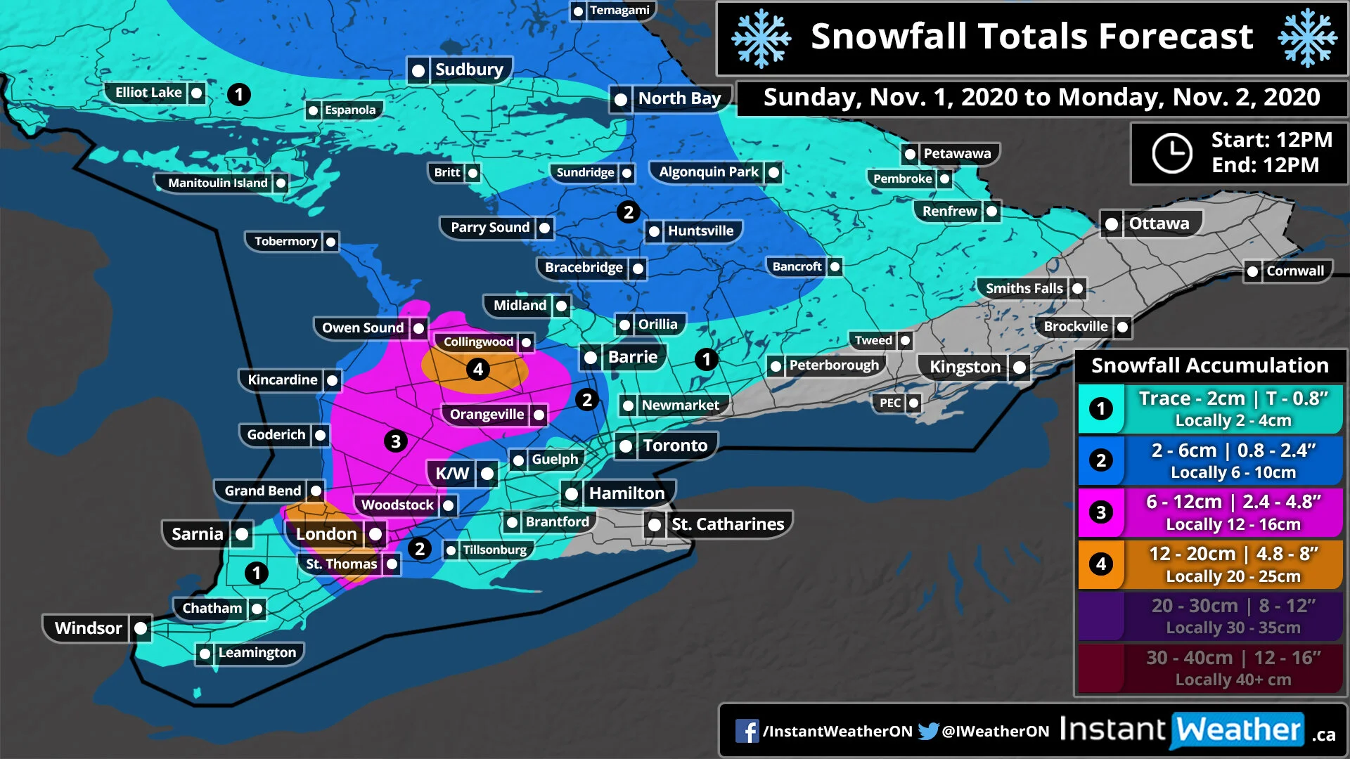
It’s going to be a wet, windy and snowy start to November for Southern Ontario as an Alberta clipper is moving across our region. Sunday started quite mild by November standards with temperatures early this morning reaching into the mid to upper single digits and heavy rain courtesy of the Alberta Clipper. The clipper is starting to move out of our region this afternoon and behind it will be colder temperatures bringing much of Southern Ontario to near or below the freezing mark by Sunday evening and into the overnight. Lake effect snow will also develop off of Lake Huron and Georgian Bay bringing potentially up to 20cm of accumulation to some regions south of Georgian Bay and southwest of Lake Huron by Monday afternoon.

We are already seeing some gusty winds this afternoon and they will only become stronger as we head into the evening with potentially damaging wind gusts. The strongest gusts will be found around Georgian Bay and Lake Huron with gusts exceeding 90km/h and even approaching 100km/h right along the shoreline (particularly the Grand Bend, Goderich and Kincardine area). Away from the lake, we’ll still see strong winds ranging from 70-85km/h which could bring down some small tree branches and cause localized power outages. This will last overnight into Monday morning with the wind gusts subsiding after sunrise.

These strong wind gusts are expected at the same time that strong snow squalls could develop around Georgian Bay and Lake Huron overnight and into Monday morning. As a result, blowing snow and near-zero visibility is quite likely in the affected region so be sure to drive according to the conditions especially since this is the first big snowfall of the season.

Windy & Snowy Start to November for Southern Ontario; Snow Squalls to Bring Up to 20cm of Snowfall Accumulation by Monday

Hold onto your masks and maybe dust off those snow brushes and shovels! A blast of winter-like weather is expected to start the first few days of November through parts of Southern Ontario. This includes the season’s first substantial lake effect snow events around Lake Huron and Georgian Bay that could bring between 10-20cm starting Sunday afternoon and lasting into Monday. This will also be accompanied by very strong wind gusts expected to develop late Sunday into Monday morning with some areas seeing damage wind gusts over 90km/h. Due to the timing of this event, it’s certainly possible that will also see the chance at the first school bus cancellations of the season for Monday for some regions impacted by the squalls.

An Alberta clipper is expected to track into our region early Sunday morning with a very brief push of mild air causing temperatures to rise into the mid to upper single digits during the morning hours. With relatively warm temperatures, the Alberta clipper will start as moderate to heavy rainfall across Southern Ontario. Rainfall totals will range from 5-15mm with the higher totals throughout the more western part of the region. As we head into Sunday afternoon and evening we’ll begin to see temperature drop as colder air flows in behind the clipper causing temperatures to plunge near the freezing mark by the dinner hour. This will cause lingering precipitation to begin to transition over the wet snow. We’ll also start to see the lake effect machine kick into gear as conditions become favourable for lake effect showers and snow to develop.

Throughout the evening hours on Sunday, we expect the lake effect snow to become more organized as the wind direction becomes more stable. As a result, several intense snow squall bands off Georgian Bay and Lake Huron will develop just before midnight initially favouring a westerly flow pushing heavy snow east of Georgian Bay and Lake Huron. After midnight, the wind direction will shift causing the bands to sink southward with one band coming inland from Georgian Bay around the Meaford and Flesherton area. The other band will be focused on areas just the west of London affecting Lambton Shore and Strathroy. This will continue for much of the overnight hours and into Monday morning when we’ll finally see the lake effect weaken and break apart as conditions become unsupportive for snow squall activity during the late morning on Monday.

Snowfall totals will vary significantly as is typical with snow squall events with one area seeing extensive accumulation and another just a few kilometres away seeing just scattered flurries. So keep in mind that our forecast is based on the latest model data and where we believe the squalls will set up. A slight change in the wind direction could cause these zones to shift around. With that being said, the heaviest accumulation is expected south of Georgian Bay and southwest of Lake Huron including locations such as Flesherton, Lambton Shore and Strathroy where between 12-20cm of snowfall accumulation is possible. Surrounding regions including London, Hanover, Orangeville and Collingwood could see as much as 6-12cm with local totals pushing 15cm.

You might notice that we have lower totals around the Lake Huron shoreline and this is because we expect temperatures to be slightly warmer hovering near the freezing mark. This means that while they will see just as much snowfall as inland, most of it will melt on contact due to the warmer temperatures. This includes Goderich, Kincardine and Wiarton with snow totals between 2-6cm. All other areas can expect less than 5cm of total snowfall from this event.

We are also expecting a fairly strong wind storm to develop Sunday evening with wind gusts around Georgian Bay and Lake Huron exceeding 90km/h and even approaching 100km/h right along the shoreline (particularly the Grand Bend, Goderich and Kincardine area). Away from the lake, we’ll still see strong winds ranging from 70-85km/h which could bring down some small tree branches and cause localized power outages. This will last overnight into Monday morning with the wind gusts subsiding after sunrise. Now, the strong wind gusts will be occurring at the same time that we expect strong snow squalls to affect some areas through the snowbelts. As a result, blowing snow and near-zero visibility is quite likely in the affected region so be sure to drive according to the conditions especially since this is the first big snowfall of the season.

We’ll continue to monitor the latest data and issue updates as necessary!

Halloween Outlook: An Eerily Quiet Halloween With Spine-Chilling Temperatures for Southern Ontario

As we approach the spookiest day of the year, the last week of October has been full of tricks weather-wise from a late-season terrifying tornado last Friday and some frightful flurries over the past few days. Now, we’re happy to report that it appears Mother Nature has decided to stop with the tricks (for at least one day) and is going to treat us with fairly good weather on Halloween by Ontario standards. Although, you might want to consider adding some additional layers to the costume this year because temperatures across the region will be quite wicked with some parts of Central and Eastern Ontario dipping below the freezing mark during Trick-or-Treating hours.

There isn’t much to talk about with the weather across Southern Ontario on Halloween which is a good thing. So we’ll focus on the biggest story which is the colder temperatures. As mentioned, those through the higher elevations of Central and Eastern Ontario including Northern Muskoka, Algonquin Park, Bancroft and Petawawa will see temperature flirt with the freezing mark likely ending up around -1 to -3°C. Factoring in the ghoulish wind chill, it’ll feel closer to -5°C. The rest of Southern Ontario (except for those around the lakeshore) will see temperatures in the low single digits between 0 to 5°C. And finally, regions around Lake Ontario, Huron, Erie and Georgian Bay will see temperatures in the mid to upper single digits ranging from 5 to 8°C.

Just because Mother Nature has decided to treat us on Halloween doesn't mean she’s not hard at work brewing up a spooky start to November. That’s because we’re monitoring the potential for lake effect snow late Sunday into Monday off Georgian Bay and Lake Huron. It’s looking slightly weaker than a few days ago with a smaller timeframe, but it’s still possible that many areas will see their first impactful snowfall of the year with between 5-10cm and locally up to 15cm through Ontario’s Snowbelt. More details on that will be coming soon.

IMPORTANT: If you do plan to go out to celebrate Halloween, please be sure to adhere to all health guidelines surrounding COVID-19. This includes maintaining social distancing at all times, wearing a mask (costume masks DON'T count) and only getting together with people from your household. Health officials also recommend that those in Ottawa, Peel, Toronto and York Region to NOT participate in door-to-door Trick-or-Treating. Stay home and celebrate in other ways. Click HERE for more information from the Government of Ontario on how to stay safe during Halloween.

Blast of Arctic Air to Bring the Coldest Temperatures of the Season Across Southern Ontario on Friday Morning With Wind Chills Near -15°C

It’s hard to believe that less than a week ago we were talking about late summer-like weather with temperatures above 20°C and the threat of tornadoes. Now the story this Friday will be temperatures well below the freezing mark and in some cases, reaching into the negative double digits! This will no doubt be the coldest temperatures that Southern Ontario has seen this season.

Cold air from Northern Ontario is expected to flow into our region overnight Thursday. When you wake up early Friday morning, the thermometer will read between -5°C and -10°C through much of Central and Northeastern Ontario. When you factor in the wind chill it’ll feel into the double digits reaching as cold as -15°C. Further south, the temperature will be slightly warmer with temperatures between 0°C and -5°C with a wind chill between -5°C and -10°C including much of Eastern and Southwestern Ontario away from the lakes. The rest of Southern Ontario around Lake Ontario and Erie can expect temperatures flirting with the freezing mark but should stay slightly above it.

As for Halloween, the morning will start on a chilly note similar to Friday but temperatures should warm up to above the freezing mark throughout the day on Saturday in time for Trick or Treating. We’ll have more details in our special Halloween outlook that will be released either Thursday evening or Friday afternoon. Stay tuned!

We’re also closely monitoring the potential for our first substantial lake effect snow event with snow squalls developing Sunday and lasting into Monday. At this moment, the area in the bullseye for the heaviest snowfall accumulation is around Lake Huron and south of Georgian Bay, but that is subject to change. Some localized regions could see as much as 10-20cm of snowfall accumulation by the middle of next week! More details soon.

Very Isolated Risk For Marginally Severe Thunderstorms in Eastern Ontario and Parts of Northeastern Ontario

The last few weeks across Southern Ontario have certainly felt like fall with temperatures near the freezing mark and even some areas have seen the season’s first snowflakes. Although summer isn’t done just yet with one more day of well above seasonal temperatures expected on Friday. There is also the threat of severe thunderstorms as a cold front cuts across the region bringing the potential for damaging wind gusts, large hail and even an isolated tornado can’t be ruled out.

Friday will start off as quite warm by late October standards when you wake up with temperatures in the low teens across much of Southern Ontario. Even warmer air will work its way into the province from south of the border later in the day with many areas reaching into the low to mid-20s by late afternoon. In fact, almost everyone except for Northern Ontario and the higher elevations around the Algonquin Highlands will see temperatures between 20-25°C sometime during the day on Friday.

The late summer-like temperatures will be only temporary as a sharp cold front moves across the region later in the day. This will cause a very rapid drop in temperatures during the evening hours with many areas going from the upper teens or low 20s into the lower single digits in only a matter of a few hours. Some models suggest that we could see temperatures drop by 10°C or more within only one hour! Fortunately, we aren’t talking about a drop in temperatures to below the freezing mark so a flash freeze won’t be an issue as is usually the main concern with such a quick drop in temperatures.

Aside from the rapid plunge back into fall, we also expect to see a line of strong to severe thunderstorm develop ahead of the cold front during the late afternoon and early evening. The highest chance of severe weather will be along the Lake Huron and Georgian Bay shoreline as the storms move in from Michigan around the dinner hour. These storms have the potential to produce damaging wind gusts between 80-100km/h and up to quarter size hail along with heavy rainfall and frequent lightning strikes. We can’t rule out an isolated tornado from these storms which would only add to the record-breaking tornado season we’ve experienced this year. The storms will slowly weaken during the evening as the line tracks to the east with daylight heating slowly disappearing. So areas east of a line roughly from Petawawa and Brantford should see only non-severe thunderstorms by the time the line reaches them.

As we head into the weekend, temperatures will return to what we normally see during the late fall with most areas just a few degrees above the freezing mark on Saturday morning. Further north through parts of Northern and Central Ontario temperatures may drop below the freezing mark. This will continue into next week as we closely monitor the potential for more areas to experience their first snowfall of the season including parts of Eastern and even Southwestern Ontario. Although we’ll likely have to wait a few more weeks to see any noticeable accumulation. More details on that to come.

Quick Burst of Snow Across Northern Ontario Early Wednesday Morning With Up to 10–15cm; Possible Big Snowmaker to End off the Week

A fast-moving system is expected to track into Northeastern Ontario overnight Tuesday and into Wednesday bringing the potential for widespread snowfall accumulation in some areas. Snowfall will being to move into the province from Wisconsin and Minnesota sometime around the midnight hours around Lake Superior. The heaviest precipitation appears to stretch from just north of Sault Ste. Marie eastward through the Chapleau and Englehart region.

As mentioned, the system will be moving quite fast for most of the snowfall accumulation will occur during the early morning hours on Wednesday. Although flurries and light snow may linger around throughout the day as the system moves out into Northern Quebec. When it comes to the total accumulation, most areas can expect between 4-8cm south of a line from Kenora to Kapuskasing and north of the Georgian Bay shoreline (where rain will likely be the predominant precipitation type). A zone just north of Elliot Lake and south of Timmins stretching from the eastern Lake Superior shoreline to the Quebec border could see as much as 10-12cm (locally some spots may pick up close to 15cm).

We’re also closely monitoring a potential big snowmaker that could bring the biggest snowfall accumulation for Northern Ontario this season so far. Right now it looks like the heaviest snowfall will occur overnight Thursday and lasting into Friday. Some areas could see as much as 15-25cm but that is subject to change. There’s some uncertainty regarding the track of this system which would affect who sees the most snowfall. Some models have it taking a similar track as the system coming tonight which would put Northeastern Ontario in the bullseye while others have a more westerly track through Thunder Bay and Geraldton. More details in the coming days as we narrow down the track.

The First Snowfall Possible Saturday Morning for Parts of Southern Ontario As the Season’s First Snowstorm Takes Aim at Northern Ontario This Weekend

As colder temperatures and the leaves fall off the trees, it’s only a matter of time until we see the first snowfall of the season. And for some parts of Central Ontario and the higher elevations through the Dundalk Highlands, that time is Saturday morning. Although little to no accumulation is expected as is usually typical with the first snowfall of the season and should melt on contact with the ground. Temperatures will rise into the upper single digits on Saturday so if any snow does manage to stick to the ground it will quickly melt after sunrise.

Lake effect showers are expected to develop off of Lake Huron and Georgian Bay late Friday and into Saturday affecting areas east of those lakes. As we head into the overnight hours we’ll see temperatures in the northern parts of Central Ontario such as Sundridge, Algonquin Park and Huntsville drop to near the freezing mark.

This will allow for some flurries and wet snow to mix into the lake effect flurries between midnight and before sunrise (around 7 am) in the morning. The same is true for the higher elevations just to the northwest of Orangeville although this is more questionable and may not occur. As mentioned, temperatures will quickly warm up after sunrise so if you aren’t up early in the morning (or up late) then you likely won’t see any snow.

The same can’t be said for parts of Northern Ontario which is currently on track to see their first snowstorm of the season with up to 20cm of accumulation possible by the end of the weekend. This is courtesy of a combination of lake effect snow off Lake Superior and an Alberta Clipper that will move in from the US starting Saturday. Most areas can expect between 10-15cm including Thunder Bay, Geraldton and Wawa with locally up to 15-25cm, especially with those areas that see the lake effect snow. You can find our full forecast for Northern Ontario here.

Have a great weekend!!

Flurries and Localized Accumulating Snowfall Possible Across Southern Manitoba Between Friday and Saturday

As Alberta braces for the first winter storm of the season with more than 25cm of snow possible throughout the Rockies, Southwestern Manitoba will also be into the crosshairs of the same system on Saturday. The current model guidances suggest that the bulk of the moisture associated with this system will stay south of the border through North Dakota. As a result, the heaviest accumulation will be found in the southwestern corner of the province including locations such as Boissevain and Killarney.

The clipper will start to move into the province early Saturday morning just after midnight lasting for much of the early part of Saturday. These areas could see a few centimetres of accumulation or as much as 5cm although that’s questionable. The rest of Southern Manitoba will see little impact from the system with the higher chance of some flurries along the American border including Winkler and Steinbach. There is also the potential for lake effect flurries to develop off of Lake Winnipeg and Lake Manitoba throughout the day on Friday. It will be very scattered and not everyone will see them, but it could bring a few flakes to areas like Winnipeg, Gimli and Ashern.

Alberta Clipper to Deliver Southern Saskatchewan’s First Widespread Accumulating Snowfall Starting Friday

As Alberta braces for the first winter storm of the season with more than 25cm of snow possible throughout the Rockies, Saskatchewan will also be into the crosshairs of the same system. This will bring the potential for the first snowflake of the season for much of Southern Saskatchewan and even maybe a few centimetres of accumulation depending on the location. For the areas that do see the accumulation, general amounts will range from 4-8cm stretching from a zone from the Alberta border through Swift Current and towards Estevan.

We’ll begin to see the first effects of the Alberta Clipper near the Alberta border during the early to mid-afternoon on Friday. The light to moderate snowfall will continue for much of the day on Friday and into the overnight hours as it slowly spreads further to the east. South-central Saskatchewan such as Moose Jaw and Regina will see the snow sometime during the early evening. Snowfall will slowly taper off from west to east beginning early Saturday morning and fully clearing out of the province by noon.

As mentioned, the highest snow totals will be around the Swift Current, Assiniboia, Weyburn and Estevan area where we are forecasting between 6-12cm although it will likely be closer to the lower part of that range so 10+cm is unlikely. Extending outside of this region, we can expect to see a few centimetres of snowfall accumulation through Shunavon and Moose Jaw. All other areas will see just wet flurries with little to no accumulation. Please note that temperatures will be hovering near the freezing mark during the day on Friday so it might take some time for the snow to start sticking to the ground. This makes forecasting snow totals tricky as some of the expected accumulation could melt right as it hits the ground.