Yet More Snow on the Way for Southern Ontario With a Snowy System on Sunday Bringing Up to 10-20cm
/As many communities in the snowbelt regions around Lake Huron and Georgian Bay are currently digging out from locally over 50cm of snow from squalls over the past two days, another snow maker is already on the way, just in time for the final days of November.
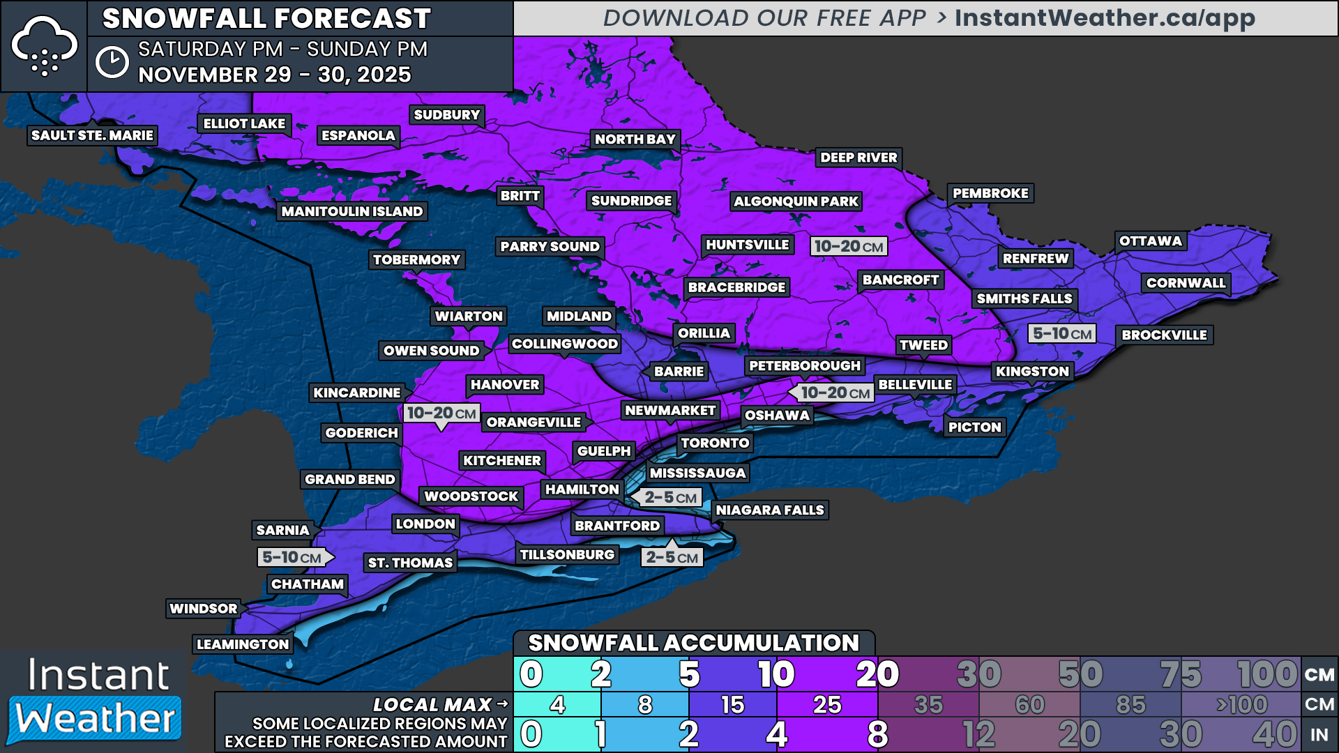
Instead of very isolated pockets seeing intense snowfall totals as we have seen with the lake effect activity, this system will spread accumulating snow across almost all of Southern Ontario. Widespread totals by the end of the weekend are expected to range from 5 to 15cm, with locally as much as 20cm in the areas that remain colder for longer.
Snowfall is expected to begin moving in from the west by late Saturday evening, starting first across Deep Southwestern Ontario. By the middle of the overnight, steady light to moderate snowfall will extend across almost all of Southern Ontario as the system further progresses into our region.
By late Sunday morning, southwesterly winds flowing across the still warm waters of Lake Erie and Lake Ontario are expected to push temperatures several degrees above freezing along the northern shorelines. This may allow the last remaining few hours of precipitation to switch over to rain for some communities right along the lakeshore.
There could also be a lake effect component to this system as it departs our region to the east. As this happens later in the day on Sunday, we may see locally heavier pockets of lake effect snow develop east of Lake Huron and Georgian Bay, which also happens to include some of the same areas hit hard by the squalls over the last few days. This could push weekend totals into the 20 to 25cm range, especially if these bands linger longer into Sunday night.
Looking ahead to the start of the week, Monday should be fairly quiet as the lake effect activity tapers off early in the morning and the remaining flurries from the system fizzle out. It will certainly be colder with everyone seeing temperatures plunge below freezing. However, that calm weather may be short-lived.
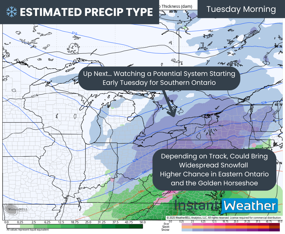
There are early indications of another potential system sliding south of the Great Lakes region. Depending on the track, this could bring another round of heavy snow throughout the early part of Tuesday, especially for areas further southeast.
Hourly snowfall rates (cm) - MAP FROM WEATHERBELL
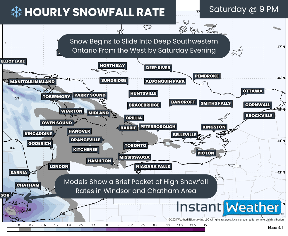
The initial bands of snowfall associated with the weekend system will begin to enter Southwestern Ontario from the west sometime just after the dinner hour on Saturday.
For most areas, the snowfall should be fairly light at first, but some models are showing the potential for several hours of heavier snowfall rates approaching 2 to 4cm per hour for Windsor, Leamington and Chatham. This could lead to a quick 5 to 10cm by the end of the night if the heavier bursts materialize.
Hourly snowfall rates (cm) - MAP FROM WEATHERBELL
As we head into the overnight hours, the system is expected to continue spreading eastward across Southern Ontario, with almost all areas seeing steady snowfall by the middle of the overnight.
Snowfall rates are not expected to be overly extreme, with most regions seeing less than 1cm per hour through Sunday morning. Even still, this snowfall is expected to continue for 6 to 12 hours, which will allow the totals to gradually build up.
Because the snow will be more widespread and less intense than recent squall activity, road crews should be able to keep up with the conditions on most major routes. Travel delays are still likely, so if you do need to drive, be sure to leave plenty of extra time and adjust your speed based on the conditions.
TEMPERATURE - MAP FROM WEATHERBELL
Winds are expected to pick up through the later part of Sunday morning, coming out of the southwest, and flowing across Lake Erie and Lake Ontario. This will push warmer air into the northern shorelines, which may allow the snow to switch over to rain directly along the Lake Erie and Lake Ontario shorelines.
Due to this transition, slightly lower snowfall totals are expected here, and some areas may struggle to reach the 5cm mark. This includes the Greater Toronto Area near the lakeshore, along with Port Colborne, Norfolk County, Tillsonburg, St. Thomas and Rondeau.
PRECIP TYPE - MAP FROM WEATHERBELL
The system is expected to gradually taper off through Sunday afternoon, leaving scattered flurries in its wake into the evening. This leftover precipitation is likely to be enhanced by Lake Huron and Georgian Bay through Sunday evening and into the overnight hours.
Expect an additional 5 to 10cm of snowfall on top of the system totals in the areas that see lake effect enhancement. This could push the end-of-weekend totals to locally as much as 20 to 25cm in the traditional snowbelt regions.
NOTE: YOU CAN CLICK ON THE MAP TO OPEN A ZOOMABLE IMAGE
When it comes to the distribution of precipitation, we expect it to fall fairly evenly across the province. However, snowfall totals will vary based on temperature differences, which will influence how efficiently the snow can accumulate.
The higher snowfall totals from this event are expected in the more northern sections of Central Ontario and extending into the Sudbury and North Bay region. This includes Parry Sound, Muskoka, Algonquin Park and Bancroft.
These regions will see more sustained below freezing temperatures throughout the event, along with lake effect enhancement late Sunday. With this, we are looking at around 10 to 20cm, with locally up to 25cm possible in the heavier lake effect pockets.
A similar situation is expected east of Lake Huron and along the higher elevations of the Dundalk Highlands and Oak Ridges Moraine, where slightly colder temperatures will help accumulations. Expect 10 to 20cm in these areas as well, with localized totals around 25cm, especially east of Lake Huron.
Everyone else, with the exception of the Lake Erie and Lake Ontario shorelines, is looking at a general 5 to 10cm. Some areas could see locally up to 15cm if temperatures end up just a bit cooler than expected. This includes the rest of Southwestern Ontario into Windsor, Chatham and Sarnia, the Lake Simcoe region and parts of the Ottawa Valley.
For communities exposed to the shorelines of Lake Erie and Lake Ontario, which includes Toronto, Oshawa, Oakville, Hamilton, Niagara-on-the-Lake, Port Colborne and Rondeau, snowfall totals will likely be closer to the 2 to 5cm range due to the warmer air intrusion and rain mixing during the latter part of the system.
PRECIP TYPE - MAP FROM WEATHERBELL
As we look into next week, we are closely watching another potential system that could have an impact on Southern Ontario throughout the day on Tuesday. There is still some uncertainty on the exact track, with the latest model runs shifting it slightly further north, which would increase impacts across a wider portion of the region. However, it could easily shift back south.
At this point, we can say there is a decent chance of 5cm or more across a wide stretch of Southern Ontario, with the highest probability being further southeast, including the Niagara region and communities along the St. Lawrence River. Be prepared for possible impacts to the Tuesday morning commute, including the potential for school bus cancellations if the system trends stronger.
Expect possible impacts to the morning commute on Tuesday, including possible school bus cancellations, should we see a stronger system.


