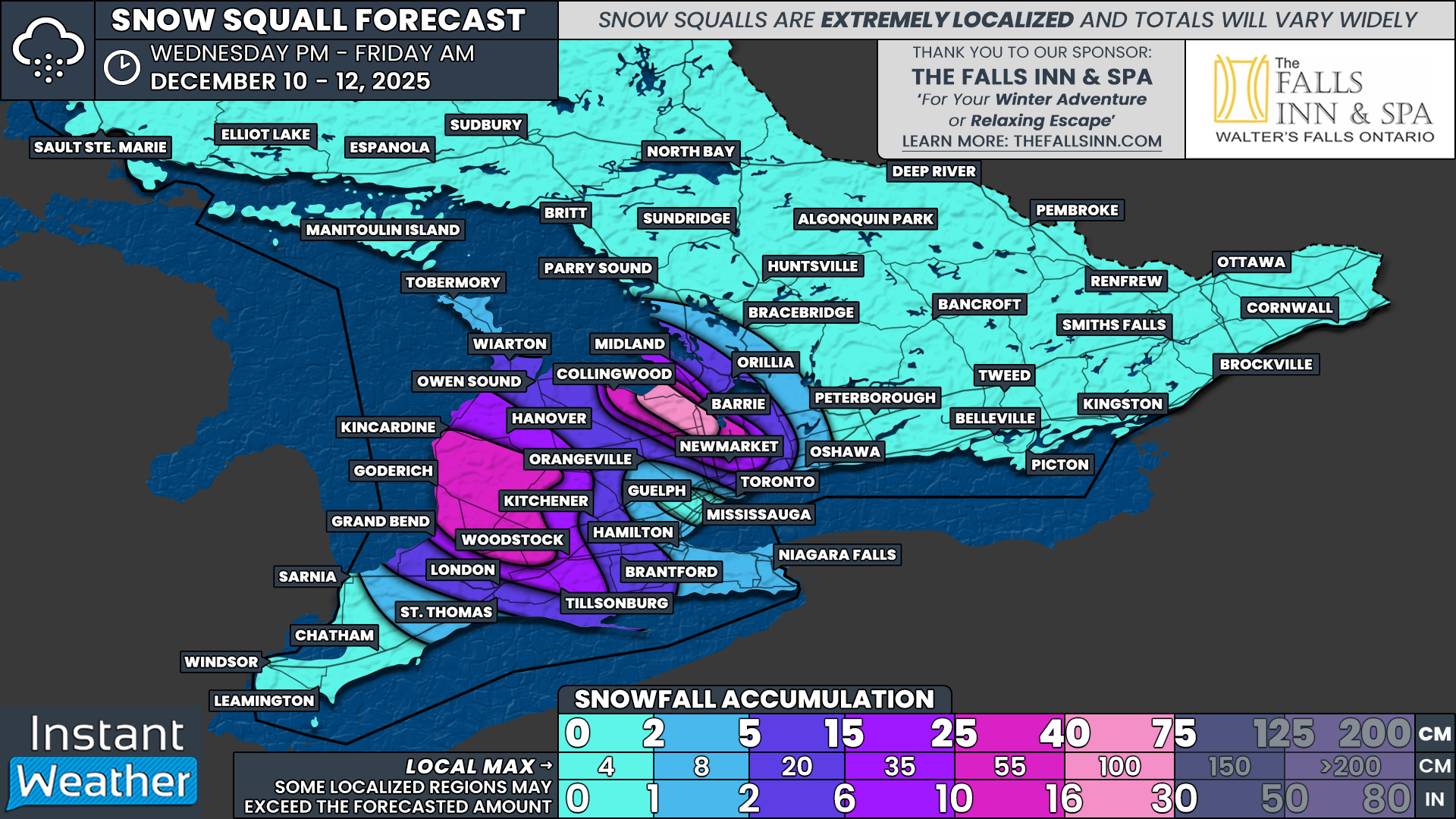
Barrie Area to Be Buried in Up to 40 to 75 cm of Snow on Thursday as Arctic Air Fuels Dangerous Snow Squalls
/
NOTE: YOU CAN CLICK ON THE MAP TO OPEN A ZOOMABLE IMAGE
Snowfall from the Alberta Clipper that slid through Southern Ontario earlier on Wednesday is beginning to taper off. The system has left its mark across the region with a widespread 10 to 20cm of snow in some areas, while others saw a slushy mix.
While the clipper may be done, the snowfall story is not. As the system pulls away, it ushers in a polar blast of cold air overnight on Wednesday. This air, combined with strong northwesterly winds, will kick the lake effect snow machine back into gear off Lake Huron and Georgian Bay.
Intense snow squalls across Simcoe, Huron and Perth counties throughout Thursday are likely to create dangerous conditions. Frigid wind chills paired with near-zero visibility will make travel extremely difficult and even life-threatening if you become stranded.
The Georgian Bay squall is expected to be particularly intense. A narrow corridor from Wasaga Beach through southwest Barrie, including Angus, Innisfil and into Bradford, may see the band lock in place for more than six hours. Snowfall rates could exceed 5cm per hour.
Localized totals around the Barrie area could approach 50 to 75cm in the hardest hit pocket. Some high resolution models even suggest 100cm is not completely off the table.
East of Lake Huron, activity will be persistent from Thursday morning through the evening. The lake effect here appears more spread out rather than focused on one specific pocket. The heaviest totals are expected across Huron and Perth counties, where up to 50cm is locally possible.
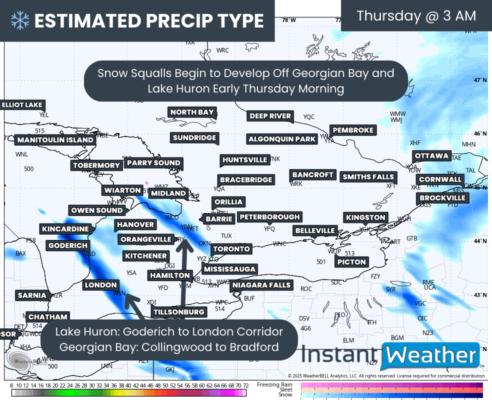
PRECIP TYPE - MAP FROM WEATHERBELL
As of Wednesday evening, we are already seeing some activity begin ramping up off the southeast shoreline of Lake Huron and Georgian Bay. This will continue to organize after midnight into the early hours of Thursday.
By early morning, we expect the most focused squalls to target the Goderich to London corridor off Lake Huron and the Collingwood to Bradford stretch off Georgian Bay.
Keep in mind, this is a rough idea from the models, and the exact placement can shift if the wind direction changes even slightly.
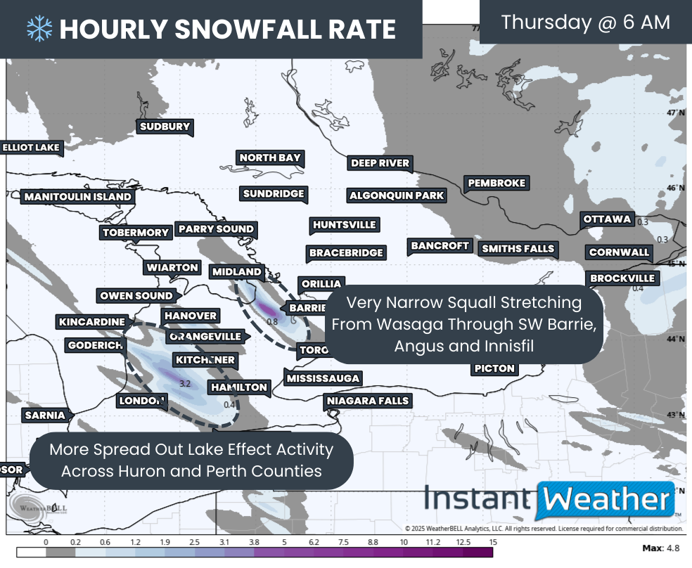
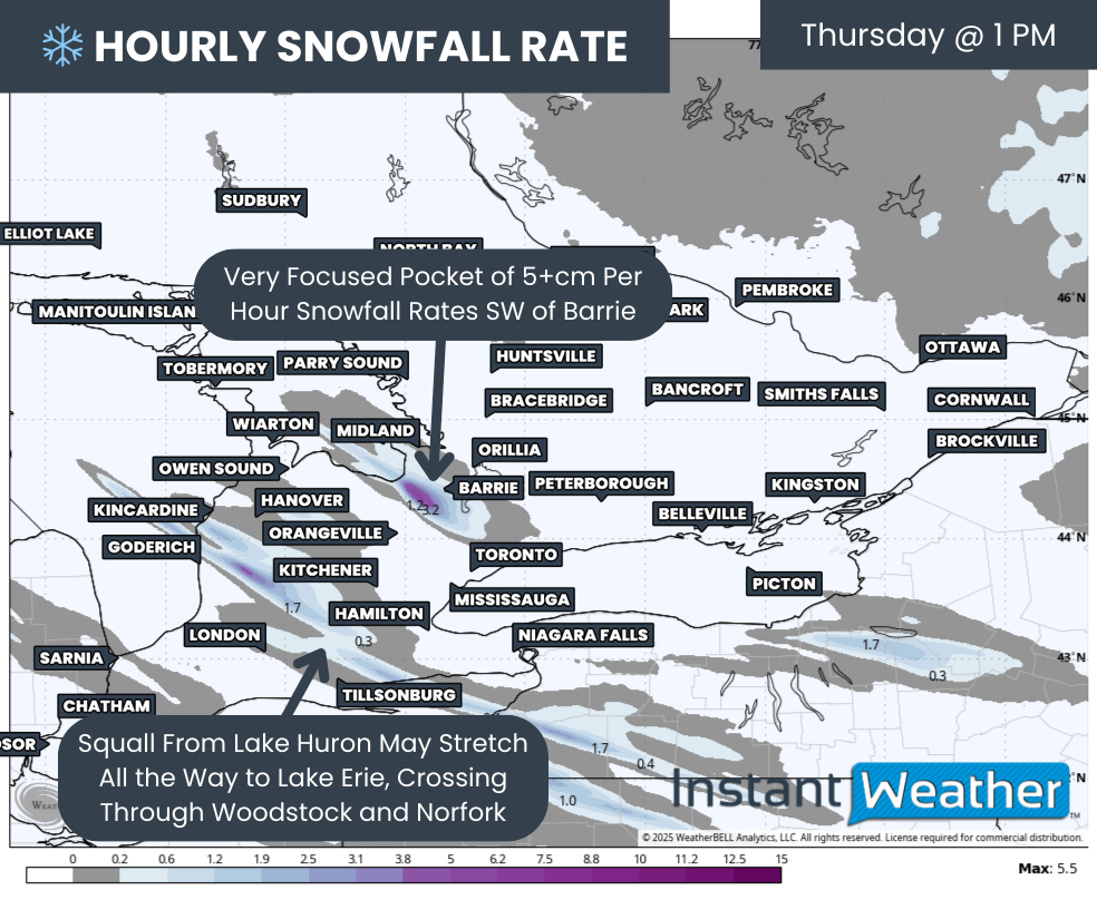
Hourly snowfall rates (cm) - MAP FROM WEATHERBELL
By the time the morning commute begins around 6 AM, snow squall activity will intensify as the Georgian Bay band becomes extremely narrow and focused. Some model runs have it stretching from Wasaga Beach through Angus and into the Innisfil to the Newmarket area.
There remains uncertainty in how much snow the City of Barrie itself will receive. The gradient between limited snow and a huge dumping will be very tight. The south and west ends are most likely to see major impacts, although it would not take much of a shift for the band to slide directly into the city.
The Lake Huron activity will begin to spread out with moderate snowfall covering much of Huron and Perth counties, including Goderich, Wingham, Stratford and Listowel. Because the band is more diffuse, there will not be one intense pocket as we expect with the Georgian Bay squall.
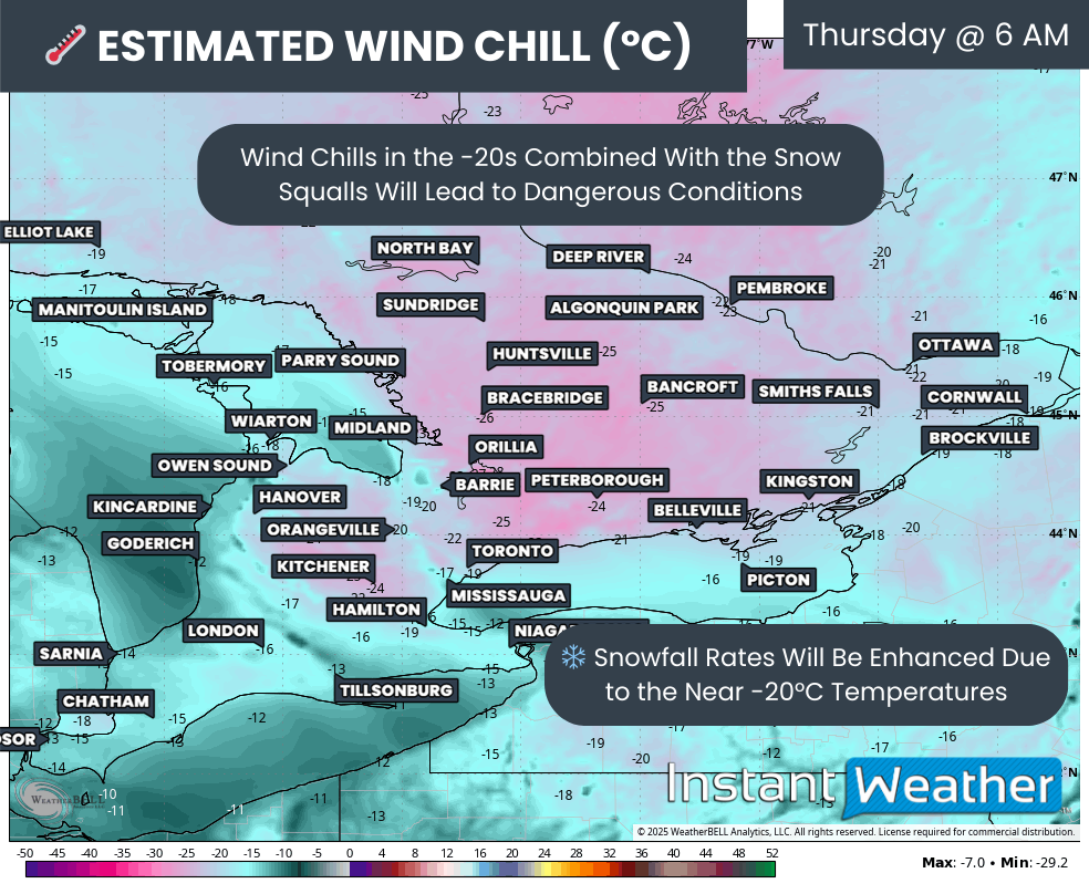
ESTIMATED WIND CHILL - MAP FROM WEATHERBELL
A major factor with this round of squalls that makes the situation more dangerous is the very cold wind chills. When you wake up Thursday, wind chills will make it feel like the -20s. Combined with squalls at the same time, the risk to anyone stranded on the roads increases significantly.
Aside from the cold creating hazards, it will also boost snowfall rates. Colder air produces drier, fluffier snow, which allows the same amount of moisture to create a larger volume of accumulation.

Hourly snowfall rates (cm) - MAP FROM WEATHERBELL
Little will change heading into the late morning as the Georgian Bay squall remains locked in place near the Barrie area. The band could edge far enough north to put the city core into the bullseye. Keswick may also be brought into the heavy snow as the band wobbles.
For the Lake Huron squall, the band may briefly become more focused as a single strong line cutting through Goderich and into Stratford and Woodstock. Depending on slight track shifts, Kitchener or Hamilton could also be affected at times.
Hourly snowfall rates (cm) - MAP FROM WEATHERBELL
Conditions are expected to deteriorate further into the afternoon. The Georgian Bay squall appears to strengthen with hourly snowfall rates easily exceeding 5cm and possibly pushing 10cm. At this point, the most intense pocket is shown just southwest of Barrie, with Angus being hit hardest.
The Lake Huron squall will also become more organized with an impressive fetch stretching all the way toward Lake Erie and impacting Woodstock and Norfolk.
Hourly snowfall rates (cm) - MAP FROM WEATHERBELL
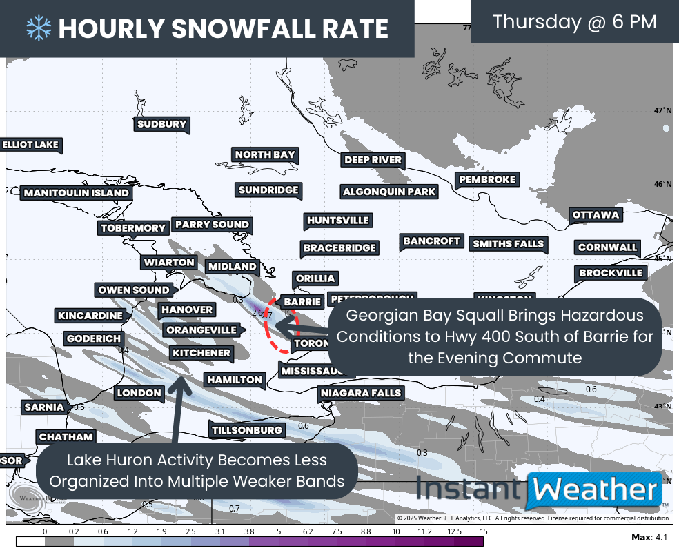
There is significant concern for the Hwy 400 corridor during the afternoon and evening commute from just south of Barrie to roughly Aurora. This section of highway will likely become snow covered with road crews struggling to keep up with extreme snowfall rates. Combined with whiteout conditions, travel in this zone should be avoided unless absolutely necessary.

Hourly snowfall rates (cm) - MAP FROM WEATHERBELL
As we head into the evening and just past midnight, the squalls will retreat closer to the lakeshores as winds weaken and moisture supply cuts off. This will lead to activity tapering to lake effect flurries overnight into Friday morning.
NOTE: YOU CAN CLICK ON THE MAP TO OPEN A ZOOMABLE IMAGE

As always with snow squalls, snowfall forecasts should be taken with a large grain of salt. While models are in good agreement on placement and intensity, nothing is guaranteed as conditions need to align perfectly.
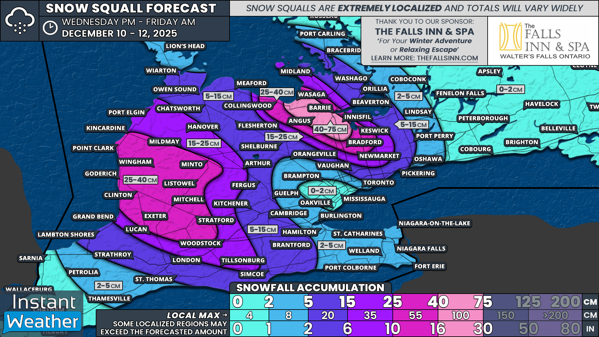
With that being said, we believe the hardest hit zone will be along the southeastern Georgian Bay shoreline from Wasaga Beach through Angus and into northern York Region. Barrie sits right on the edge but could easily end up inside the bullseye. Snowfall totals here are likely to exceed 40cm and may approach 75cm. Around Angus is where models show the strongest signal.
A tight gradient will set up with the north and east sides of Barrie, along with Keswick, Bradford and Collingwood, likely seeing 25 to 40cm of snow.
East of Lake Huron including Kincardine, Minto, Point Clark, Wingham, Listowel, Mitchell, Stratford, Exeter and Goderich, totals of 25 to 40cm are expected. Localized amounts up to 55cm are possible if a squall locks in place for several hours.
Totals of 15 to 25cm are possible for Midland and into central York Region including Newmarket and Aurora as well as Durham Region around Uxbridge. These areas will see occasional bursts of heavy snow near the edge of the main bands.
Southern Bruce and Grey counties along with Wellington County including Arthur and Oxford County may also see 15 to 25cm but totals depend on how far inland the bands extend.
Between 5 and 15cm is possible across the rest of York and Durham Region as well as northern Simcoe County including Orillia, Owen Sound, Shelburne, Fergus, Kitchener, Brantford and London. These locations sit farther from the core activity so most will see closer to 5cm with higher amounts only if a band stretches farther inland.
Less than 5cm is expected outside the snowbelt regions including Eastern Ontario, Deep Southwestern Ontario and the Golden Horseshoe.


