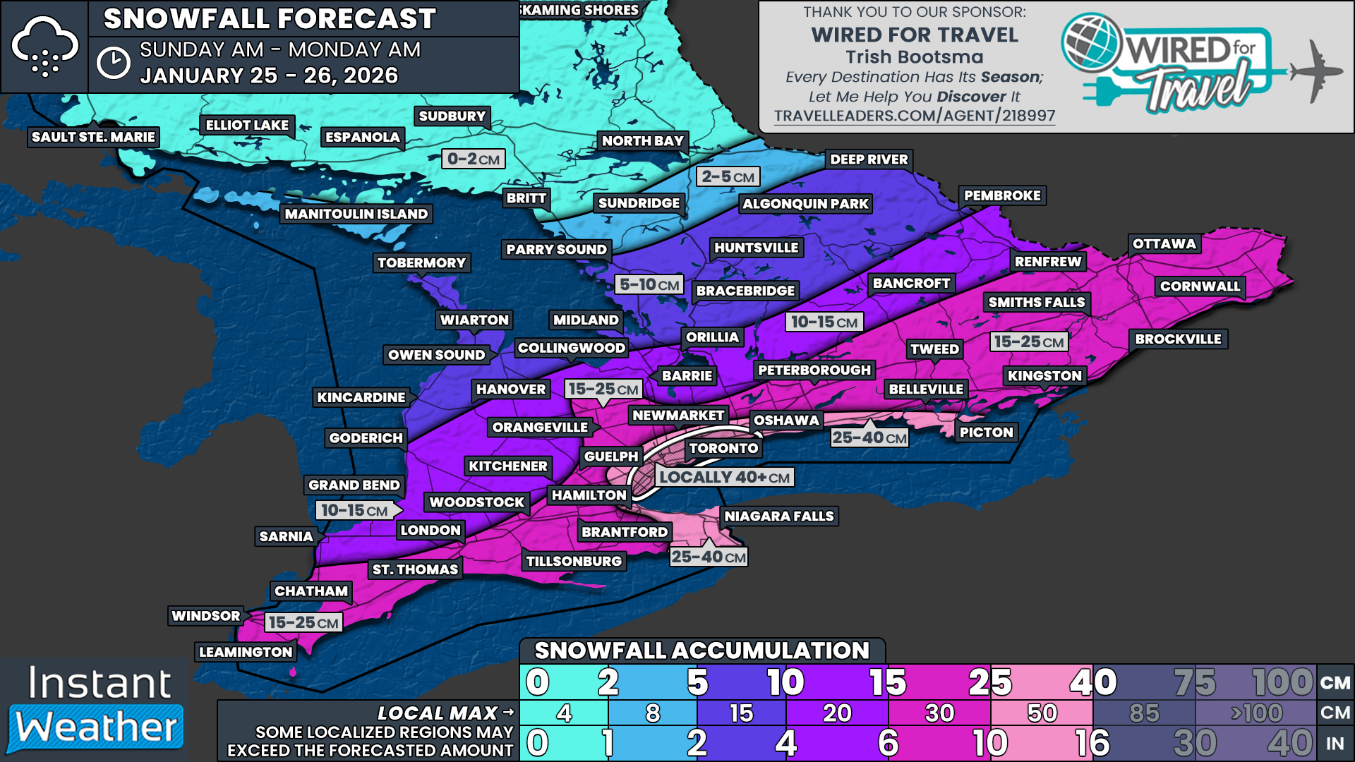
25-40cm of Snow Possible Around Toronto on Sunday as Widespread Snowstorm Threatens Travel Across Southern Ontario
/
Enter to Win a 7-Night Cruise for 2 with Celebrity Cruises, Including Airfare - Select Patricia Bootsma as your travel consultant
NOTE: YOU CAN CLICK ON THE MAP TO OPEN A ZOOMABLE IMAGE
An expansive and high-impact winter storm is currently bearing down on a large portion of the United States this weekend, bringing widespread heavy snowfall and areas of crippling freezing rain to parts of the Southeast and the Northeastern US. This is a powerful and dynamic system that is already causing significant concern south of the border, with dangerous travel conditions, power outage risks and major disruptions expected in many states.
Southern Ontario will not be spared entirely from this storm. While we will avoid the worst of the freezing rain and blizzard conditions seen farther south, we are firmly in line to be clipped by the northwestern edge of this system on Sunday. That will be enough to deliver a widespread and impactful snowstorm across much of the region.
The axis of heaviest snowfall is expected to stretch from near the Lake Erie shoreline, through the Golden Horseshoe, and eastward into Eastern Ontario. Travel impacts are likely to be significant, especially as the most intense snowfall rates arrive during the afternoon and evening hours on Sunday, a time when roads are typically busiest. Although thankfully on the weekend, which should help keep traffic volumes lower compared to a workday.
For many areas, general snowfall totals are expected to range between 15 and 25cm. This includes a broad zone covering Windsor, London, Kitchener, Kingston, Peterborough and Ottawa. However, snowfall amounts will not be uniform, and some regions will see considerably higher totals due to lake enhancement and mesoscale banding features.
The greatest concern continues to focus on the Golden Horseshoe and the Lake Ontario shoreline, where lake enhancement is expected to play a major role. In these areas, snowfall totals are likely to exceed 25cm, with some locations pushing well beyond that threshold by the time the snow tapers off late Sunday night.
There is growing confidence in the development of a persistent and narrow band of lake effect snow becoming embedded within the broader system snowfall. This feature is expected to impact parts of the Greater Toronto Area and the northwestern and western shoreline of Lake Ontario. When lake effect bands become embedded within a large-scale storm like this, snowfall rates can intensify dramatically over a very small area.
This creates an unusual and high-risk setup where the most impressive snowfall totals of the entire event may end up falling over the most densely populated portion of Southern Ontario. In some neighbourhoods, it cannot be ruled out that total snowfall may approach or even exceed 40cm.
If that scenario materializes, it would place this event among the more significant snowfall events Toronto has seen in recent memory. At the same time, it is important to stress that totals will vary sharply over short distances depending on where this narrow band ultimately sets up.
Snow falling at this intensity, especially over a relatively short 12 to 16-hour window, is likely to cause major issues across the urban core of the Greater Toronto Area. Rapid accumulation during the afternoon and evening could overwhelm road crews, making it difficult to keep up with clearing operations.
It is very possible that some major routes could see closures if conditions deteriorate quickly, including portions of the DVP, the Gardiner Expressway and sections of the 400 series highways.
Although the snow is expected to gradually wind down overnight into Monday morning, impacts will linger well beyond the end of the snowfall. The Monday morning commute is likely to be heavily affected, with many roads still uncleared or partially cleared. This increases the likelihood of school bus cancellations and even potential school closures across the hardest hit regions.
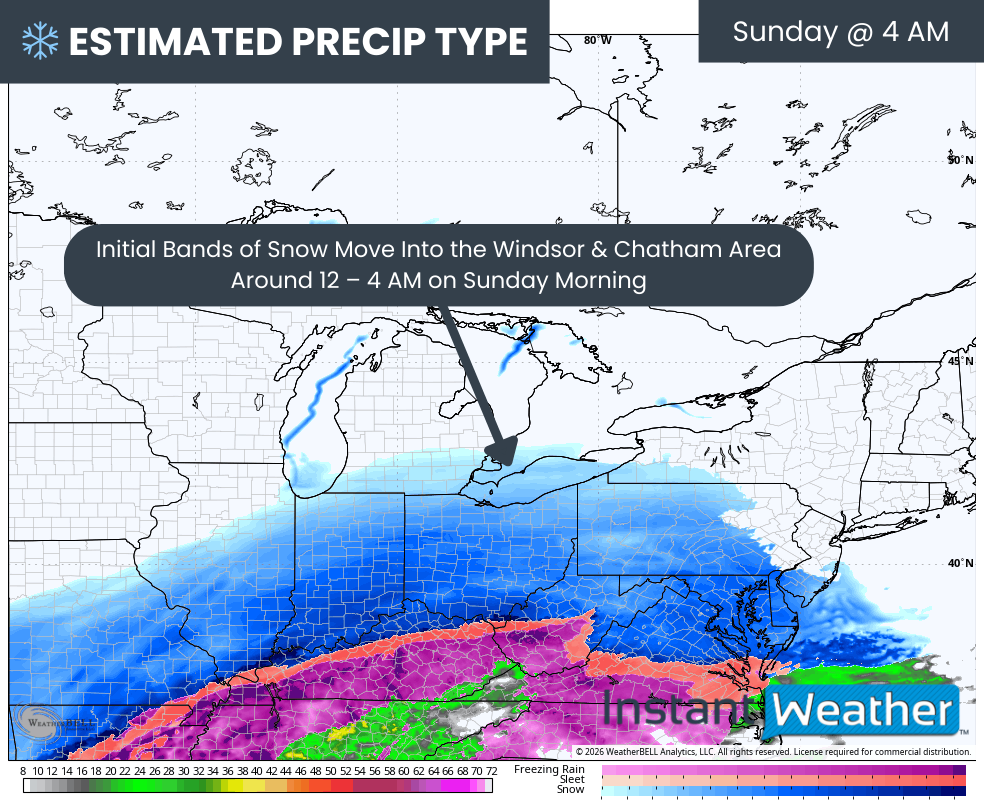
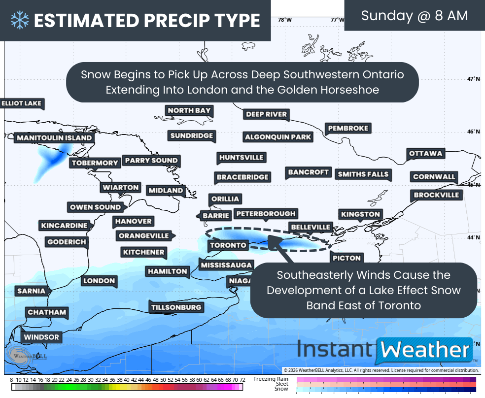
The timeline for this storm begins during the overnight hours into early Sunday morning. Initial bands of light to moderate snow are expected to move into Deep Southwestern Ontario first.
Areas like Windsor and Chatham should see snow begin around 2 to 4 AM, with coverage and intensity increasing steadily through the morning hours.
PRECIP TYPE - MAP FROM WEATHERBELL
As the morning progresses, the snow shield will expand northeastward, reaching London, Hamilton, Kitchener and the Niagara region by late morning. Snow may start off relatively light in these areas, but conditions will deteriorate as snowfall rates increase heading into the afternoon.
At the same time, a notable lake-driven feature is expected to develop over Lake Ontario. This feature may look like a “snow snake,” a narrow but intense band of lake effect snow that forms when cold Arctic air interacts with an unusual southeasterly wind flow. This is not a common setup, as southeasterly flows are typically associated with warmer air rather than when cold air is pushed in from the north or west.
This band is expected to first impact the northwestern shoreline of Lake Ontario, including portions of the Highway 401 corridor between Cobourg and Oshawa. Heavy snowfall rates are possible within this band even before the broader system snow arrives. In a short period of time, this could lay down 10 to 20cm of snow before noon in some areas.
PRECIP TYPE - MAP FROM WEATHERBELL
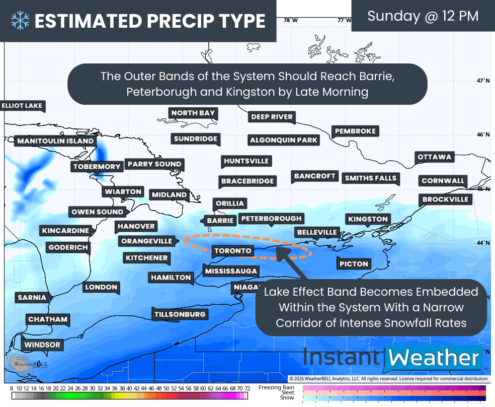
By early afternoon, snowfall will ramp up significantly across much of Southern Ontario. More widespread, steady and heavy snow will overspread the Lake Erie shoreline and the Golden Horseshoe. The outer edge of the precipitation shield should reach areas from Barrie through Peterborough and into Kingston between roughly 11 AM and 1 PM.
One of the most critical elements of this forecast is how the system snow interacts with the lake effect band. As the main storm moves in, it is expected to absorb this lake effect band, but the band does not disappear. Instead, it continues as an embedded zone of enhanced snowfall, focused primarily on the eastern GTA, including Oshawa, Ajax and Whitby during the early afternoon. These areas will benefit from an added moisture source, resulting in higher snowfall rates than surrounding regions.
Hourly snowfall rates (cm) - MAP FROM WEATHERBELL
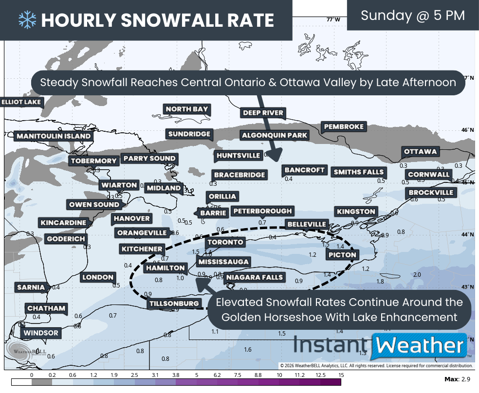
Snow will continue spreading northeast through the afternoon, eventually reaching Central Ontario and the Ottawa Valley by the mid to late afternoon. Similar to elsewhere, snow may begin on the lighter side but is expected to intensify into the evening hours for Eastern Ontario.
High-resolution model guidance continues to highlight an area of particularly intense snowfall rates across the Golden Horseshoe, driven by lake enhancement from Lake Ontario. Snowfall rates of 2 to 3cm per hour appear likely, with localized pockets potentially exceeding that where the embedded band becomes stationary.
The most intense part of this band may slowly drift westward into the Toronto area and linger for several hours during the late afternoon and early evening.
This is the window when snowfall could accumulate extremely quickly, potentially reaching 5cm per hour or more at times. Because this band will be very narrow, snowfall totals will vary dramatically from one neighborhood to the next. It is entirely possible for one part of the GTA to receive double the snowfall of another area only a few kilometres away.
Wind will also play a role, with gusts occasionally reaching 40 to 60 km/h. This will lead to areas of blowing snow and reduced visibility. While widespread blizzard conditions are not currently expected, localized blizzard-like conditions with near zero visibility cannot be ruled out under the heaviest snowfall bands.
Hourly snowfall rates (cm) - MAP FROM WEATHERBELL
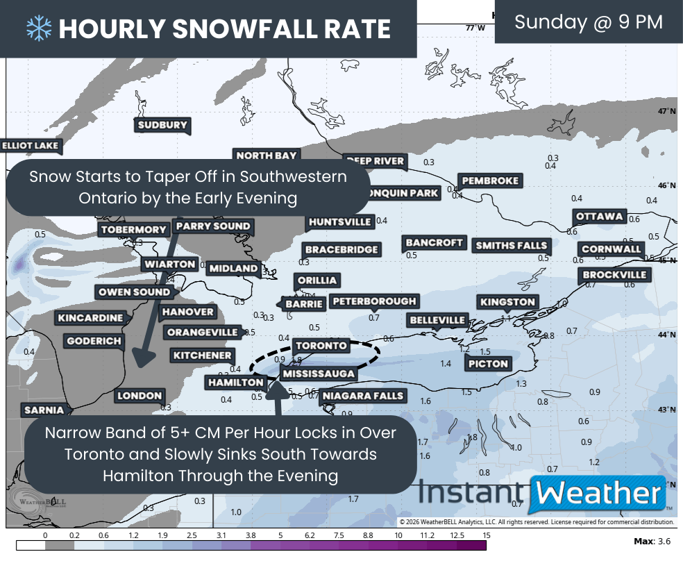
As the storm system pushes east into New England and Atlantic Canada, snowfall will begin to taper off across Southwestern Ontario during the evening hours. However, Eastern Ontario will just be reaching its peak snowfall during this time, with steady snow continuing through the evening from Kingston to Ottawa.
Across the Golden Horseshoe, conditions may actually worsen heading into Sunday evening as winds shift from easterly to northeasterly. This wind shift is expected to further intensify the lake effect band, allowing it to slide westward from Toronto into Mississauga, Oakville and eventually Burlington through the evening. Travel between Toronto and Hamilton during this period could be extremely difficult, and non-essential travel should be avoided if possible.
Hourly snowfall rates (cm) - MAP FROM WEATHERBELL
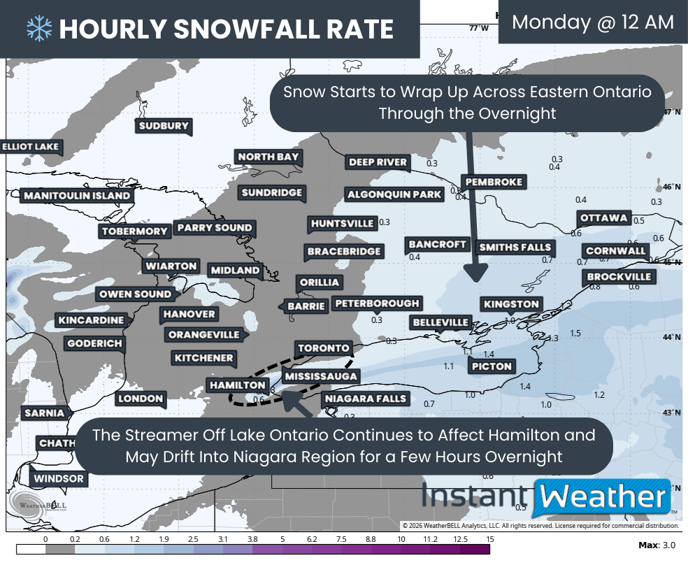
As Sunday night turns into early Monday morning, the bulk of the snowfall will become focused over Eastern Ontario as it winds down across most other parts of Southern Ontario.
The main exception will be the persistent lake effect band off Lake Ontario, which will now be free from the larger system. This band is expected to drift southward into Hamilton and potentially the northern Niagara region, including areas like Grimsby and St. Catharines, and could linger into the mid-morning hours on Monday.
For Eastern Ontario, snowfall should come to an end by around sunrise on Monday. However, the impacts will be far from over, as the amount of snow on the ground will almost certainly bring the Monday morning commute to a crawl.

NOTE: YOU CAN CLICK ON THE MAP TO OPEN A ZOOMABLE IMAGE

When all is said and done, snowfall totals by Monday morning will be highly variable, especially in areas affected by lake enhancement. A widespread zone along the Lake Ontario shoreline through the Golden Horseshoe is expected to see 25 to 40cm of snow.
This includes Picton, Brighton, Cobourg, Oshawa, Pickering, Toronto, Vaughan, Brampton, Mississauga, Oakville, Burlington, Hamilton, St. Catharines and Niagara Falls. Within this zone, the highest totals near 35 to 40cm will be very localized where the most intense lake enhancement persists, while many areas will fall closer to the 25 to 30cm range.
A smaller and more targeted corridor, including Oshawa, Pickering, Toronto, Vaughan, Mississauga and Oakville, has the potential to exceed 40cm if the lake effect band becomes particularly intense or remains stationary for several hours. This will lead to dramatic differences in snowfall even between nearby neighbourhoods.
NOTE: YOU CAN CLICK ON THE MAP TO OPEN A ZOOMABLE IMAGE
A broader area stretching from Windsor through London, Peterborough and into the Ottawa Valley can expect snowfall in the 15 to 25cm range. Some localized areas, particularly along the St. Lawrence River in Eastern Ontario, could see amounts closer to 30cm.
Snowfall totals will drop off farther northwest across Southern Ontario. Areas such as Sarnia, Goderich, Collingwood, Barrie, Orillia, Bancroft and Renfrew are currently forecast to receive 10 to 15cm. This zone remains highly sensitive to the exact northern edge of the precipitation shield, meaning totals could end up lower if the storm trends south, or higher if snowfall becomes more widespread than expected.
Finally, less than 10cm of snow is expected across Grey Bruce, Muskoka and Algonquin Park. For these regions, this will be a welcome break after enduring near continuous snow squall activity over the past week.

NOTE: YOU CAN CLICK ON THE MAP TO OPEN A ZOOMABLE IMAGE
We know the real question on everyone’s mind is not how much snow is coming, but how many bags of storm chips are required to survive it. We’ve got you covered with our very non-scientific ‘storm chips’ forecast!
The heaviest snow is expected to focus along the western shoreline of Lake Ontario and extend into parts of the Greater Toronto Area, including Oshawa, Vaughan, Toronto, Mississauga, Brampton, Oakville and Burlington.
With widespread totals expected in the 20-40cm range, this is the kind of snowfall that doesn’t disappear overnight. Dense urban areas tend to grind to a halt during storms like this, and snow removal can take several days before things feel remotely normal again.
For that reason, we’ve officially dusted off the pink crayons. If you’re in this zone, we recommend a strong 4-5 bags of storm chips and about 15-20 cups of your favourite storm beverages to get you through the digging out phase.
Elsewhere along the Lake Ontario shoreline, from Kingston through Peterborough and around the Golden Horseshoe into Kitchener, Hamilton and the Niagara Region, impacts should still be solid. This zone is looking at a respectable 3-4 bags of storm chips and roughly 10-15 cups of storm drinks to ride out the storm in comfort.
Across the rest of Eastern Ontario into Deep Southwestern Ontario, including the Ottawa Valley, Barrie, and stretching down toward Windsor and London, snowfall totals in the 10-20cm range are expected.
While not extreme, this amount of snow will still make travel messy on Sunday and likely keep you home for the day. A sensible 2-3 bags of storm chips and 5-10 cups of storm drinks should do the trick here.
Further north into Central Ontario and Grey-Bruce, snowfall amounts look lighter, generally under 10cm. Considering what these areas have already endured from relentless snow squalls over the past week, this is almost a break. Still, it never hurts to be prepared, so we suggest 1-2 bags of storm chips and 2-5 storm drinks, just in case.