Another Major Snowstorm Targets the GTA and Parts of Southern Ontario on Sunday With Up to 20-40cm of Snow
/
NOTE: YOU CAN CLICK ON THE MAP TO OPEN A ZOOMABLE IMAGE
It has been just over a week since a high-impact snowstorm swept across Southern Ontario last Thursday, bringing widespread disruption and heavy snowfall to many communities. The hardest hit areas were centred on the Greater Toronto Area, where some neighbourhoods picked up more than 30 cm of snow in a relatively short period of time. That storm caused major travel issues, school disruptions, and a lengthy cleanup that is still fresh in many people’s minds.
That’s why the forecast for this upcoming weekend may sound eerily familiar. Another snowstorm is increasingly likely to impact many of the same areas that were hit last week. While this system will not be identical, there is once again the potential for significant snowfall, especially across the Golden Horseshoe. Some parts of the region could be digging out from over 20 cm of snow by Monday morning, with localized higher amounts still very much on the table.
A large and powerful winter storm that is expected to have a widespread impact across much of the Central and Eastern United States will begin pushing northward toward Southern Ontario on Sunday. This is a major system that will be producing destructive ice storm conditions in some areas and blizzard conditions in others south of the border. Thankfully, we will not see the worst of this storm locally.
Instead, Southern Ontario is expected to be brushed by the northeastern fringe of this expansive system. While that may sound like a glancing blow, it is more than enough to cause problems here. When combined with lake enhancement off Lake Ontario, this setup has the potential to produce a disruptive and high-impact snowstorm for the Golden Horseshoe and parts of Eastern Ontario.
One of the biggest challenges with this forecast continues to be how far northwest the main bands of precipitation are able to push. Weather models are still not fully aligned on the exact placement of the heaviest snow, and that will make a big difference in who sees the highest totals. Central and Southwestern Ontario currently sit right on the edge of the storm’s reach.
If the system tracks a bit further east, some of these areas could see very little snow at all. On the other hand, a slightly more western track would bring accumulating snow much deeper into Southern Ontario and significantly expand the impact zone.
Confidence is much higher for areas closer to and east of the Lake Ontario shoreline. Regardless of the exact track, these regions are expected to see accumulating snow.
What remains uncertain is just how high the totals will climb. In a lower impact scenario, snowfall amounts would generally range from 20 to 25 cm around the GTA, with 10 to 20 cm extending eastward along the Lake Ontario shoreline into Eastern Ontario.
In a higher-end or overperforming scenario, localized pockets could approach 40 cm of snow, especially in and around the Toronto area. In that case, totals over 20 cm could extend across much of Eastern Ontario, parts of Central Ontario, and even into portions of Deep Southwestern Ontario. At this point, both outcomes remain plausible depending on how the system evolves.
Regardless of the final totals, this storm is expected to produce hazardous travel conditions, especially as snowfall intensity ramps up Sunday afternoon and evening. Roads are likely to become snow-covered and slippery, with visibility reduced at times during heavier bursts of snow. Conditions should slowly begin to improve overnight into Monday morning, but the impacts will not end there.
Given the amount of snow that is likely to fall, there is a high probability of significant impacts to the Monday morning commute. This includes the strong potential for school bus cancellations and school closures across parts of Southern and Eastern Ontario. Even if snowfall tapers off before daybreak, cleanup operations will still be ongoing during the morning hours.
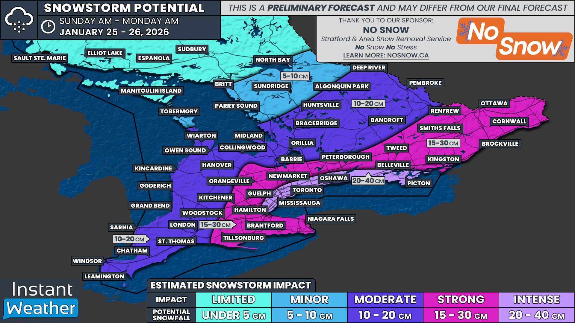
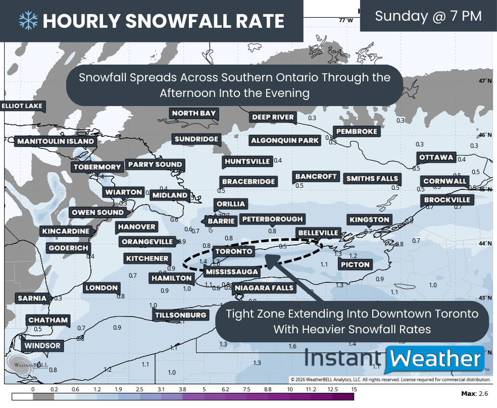
Hourly snowfall rates (cm) - MAP FROM WEATHERBELL
While we will have a more detailed look at timing in our final forecast late Saturday, current data suggests snowfall will begin to spread over parts of Southern Ontario late Sunday morning. Steady snow is expected to reach Deep Southwestern Ontario around 8 to 9 AM, gradually expanding northeastward through the day.
At the same time, there are growing signals that a lake effect snow band may develop over Lake Ontario and extend into areas north and northwest of the lake. This band could stretch from Belleville along the Highway 401 corridor, through Toronto, and westward toward Hamilton. This is an important detail, as lake enhancement could significantly boost snowfall totals in a narrow corridor.
High-resolution models are just beginning to come into range, but early indications show elevated snowfall totals along this corridor. In some cases, 10 to 20 cm of snow could fall even before the main system snow arrives later Sunday afternoon and evening. This would set the stage for very high totals once the storm fully ramps up.
Hourly snowfall rates (cm) - MAP FROM WEATHERBELL
The steadier, more widespread snow associated with the main system will continue to spread northeastward during the afternoon. Snowfall intensity is expected to increase through the Golden Horseshoe and into Central and Eastern Ontario as the evening progresses, with the heaviest rates focused near Lake Ontario.
Models are also hinting at the possibility of an embedded lake effect streamer developing and narrowly extending into parts of the western GTA. This includes Downtown Toronto and potentially Mississauga. If this band materializes, it would likely develop sometime during the afternoon and intensify into the evening hours.
The exact placement of this feature is highly uncertain and could shift around considerably. Because of that, snowfall totals could vary dramatically over relatively short distances. Where this band sets up, snowfall rates could double or even triple compared to surrounding areas, leading to very rapid accumulation in a short amount of time.
As the system begins to wind down overnight, this pocket of lake enhancement is expected to gradually weaken. Current model guidance suggests it may slowly sink southward through areas like Oakville, Burlington, and Hamilton as winds shift from easterly to northeasterly. This could prolong snowfall in those communities even as conditions improve elsewhere.
Most areas should see the snow taper off by around sunrise on Monday. However, parts of Eastern Ontario may see steadier snow linger through the morning hours before finally ending by the afternoon. Even after the snow stops, cleanup and travel impacts will continue for much of the day.

NOTE: YOU CAN CLICK ON THE MAP TO OPEN A ZOOMABLE IMAGE

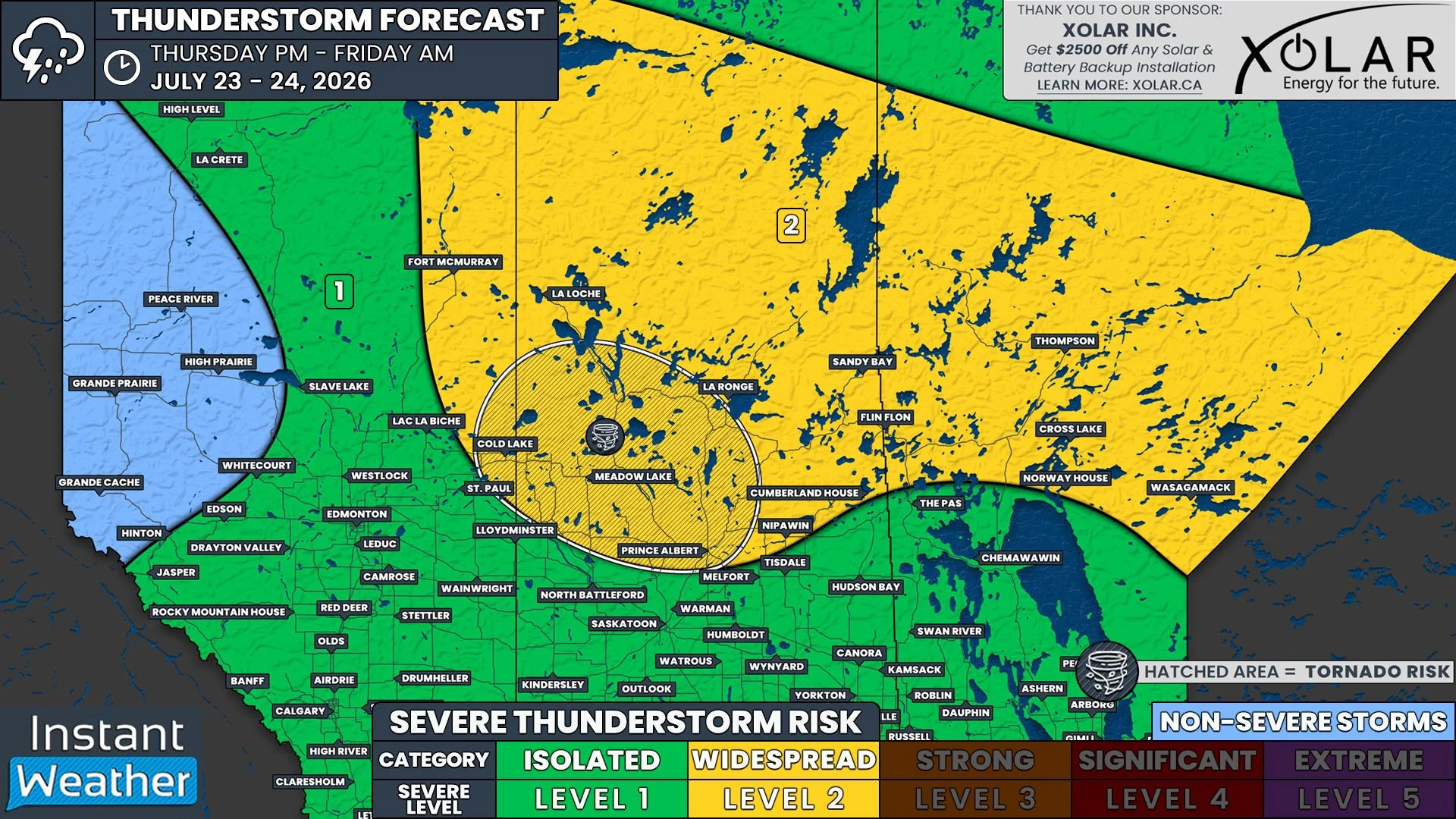
When it comes to potential snowfall totals, this is shaping up to be a storm with significant variability, even across small areas. The lake enhancement component means there will likely be a narrow corridor somewhere through the GTA where totals approach or even exceed 40 cm, while nearby locations receive much less.
At this time, the highest totals are expected along the northern and western shoreline of Lake Ontario. Snowfall amounts in this zone are forecast to range from 20 to 40 cm. This includes areas such as Picton, Belleville, Brighton, Cobourg, Oshawa, Pickering, Toronto, Vaughan, Mississauga, Oakville, and Burlington.
Somewhere between Oshawa and Oakville, localized pockets near 40 cm appear most likely, which seems to be likely focused on parts of Toronto. Outside of those hotspots, much of this corridor is expected to fall into the 20 to 30 cm range. There is still a chance that totals could exceed 40 cm if the lake enhancement band is stronger or lingers longer than expected, though recent model runs suggest less overperforming potential than earlier data.
The rest of the Golden Horseshoe and much of Eastern Ontario away from the immediate Lake Ontario shoreline can expect generally 15 to 30 cm of snow from this storm. This includes places like Niagara, Brantford, Kitchener, Guelph, Orangeville, Newmarket, Peterborough, Kingston, Brockville, Ottawa, and Cornwall. We expect to tighten this range further once the storm track becomes clearer.
For Southwestern Ontario into parts of Central Ontario, current projections suggest totals in the 10 to 20 cm range. However, there is expected to be a very sharp cutoff on the northwest edge of the precipitation shield. This means snowfall totals could drop off quickly over short distances.
If the system does not extend far enough northwest, areas east of Lake Huron and Georgian Bay could end up being mostly clipped by the snow, with minimal accumulation. In contrast, Deep Southwestern Ontario including Windsor, Chatham, and London appears most likely to see at least 10 cm of snow regardless of the final track.
Overall confidence in this forecast is fairly high thanks to strong agreement among most weather models. That said, the storm is still more than 24 hours away. This forecast remains preliminary and could change if there is a last minute shift in the data. While a major surprise is unlikely given the current consistency, it cannot be completely ruled out.
Our final forecast will be published Saturday evening once the latest data is available. At that time, we will provide a more precise snowfall range and a detailed timing breakdown so you have a clearer picture of what to expect throughout the day on Sunday and into Monday.