First Major Winter Storm of the Year Will Bring Up to 50cm of Snow and Blizzard Conditions to Saskatchewan & Manitoba
/NOTE: YOU CAN CLICK ON THE MAP TO OPEN A ZOOMABLE IMAGE
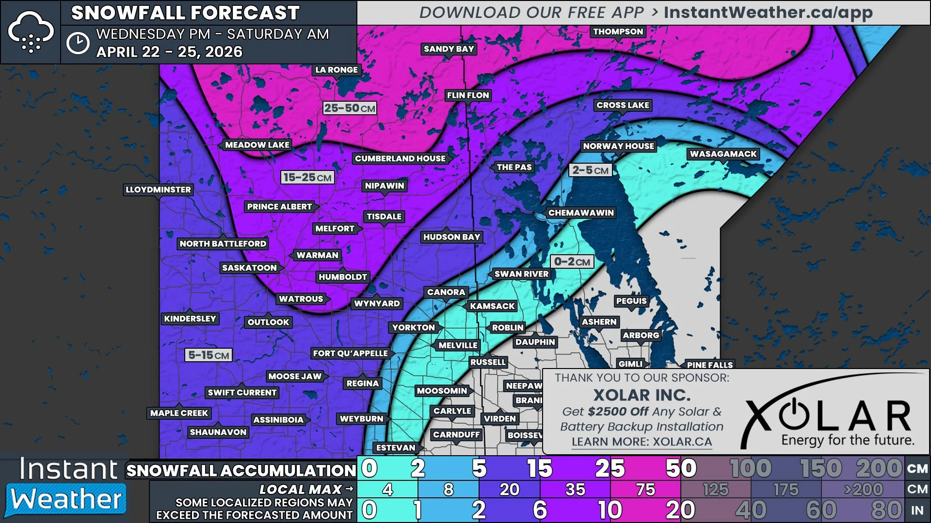
The first major winter storm of the season for the Prairies is here, with rain already falling in Southeast Saskatchewan along with pockets of freezing rain and snow. In last night’s preliminary forecast, we discussed the complexity of this multi-day storm and now that the storm is on our doorstep, there is more confidence in the forecast. Some areas of Central and Northern Saskatchewan and into Northern Manitoba could now see upwards of 50cm by the end of Wednesday, with blizzard conditions possible in the south.
As mentioned above, the first round of precipitation from this event has already made its way into Saskatchewan this afternoon. Rain is falling in Southeast and East Central Saskatchewan and there is snow further north, in the Hudson Bay area. The rain will transition over to snow as we progress through the evening with the heaviest snow expected to fall east of Prince Albert, from Melfort through to Cumberland House, starting later in the evening and continuing straight through to Wednesday morning.
As this band of precipitation pushes eastward into Manitoba overnight and into the early morning hours of Tuesday, it will encounter a strong low pressure system coming north out of the States. This incoming system from the south will bring steady rain, that is heavy at times, to Southern Manitoba throughout Tuesday morning. When the two systems meet, they will merge to form one large storm and by late Tuesday morning, cooler air will be pulled towards the centre of the storm from Northern Saskatchewan, leading to a transition of rain to snow with a brief period of freezing rain in the Westman Region.
By Tuesday afternoon, the snow will start to ease in Saskatchewan, but snowfall rates in Manitoba, on the other hand, will increase, leading to quick accumulations of snow. It’s at this point that the winds will start to pick up. Sustained winds of 40km/h and gusts exceeding 70km/h, combined with the heavy snowfall, will likely lead to blowing snow and blizzard conditions overnight Tuesday through to Wednesday morning.
This storm will finally diminish Wednesday afternoon, leading to a gradual tapering off of snow throughout the region.


