‘Blizzard Conditions Possible’; Winter Storm Could Dump Up to 30cm of Snow on Parts of Saskatchewan and Manitoba Early This Week
/Mother Nature isn’t holding back as a powerful winter storm sets its sights on Saskatchewan and Manitoba, starting late Monday. This storm will bring heavy snow, strong winds, and even blizzard conditions, marking the region’s first significant taste of winter. Some areas in Eastern Saskatchewan and Western Manitoba could see up to 30 cm of snow, with localized amounts possibly exceeding that by the end of Wednesday.
Sustained winds of 40 km/h, with gusts reaching 70–80 km/h, are expected to create blowing snow, particularly overnight Tuesday into Wednesday morning. Blizzard conditions could develop in some areas. Prepare for hazardous travel, as highway closures are likely in the hardest-hit regions.
Before diving into the details, it’s important to note that this is a complex storm, with snowfall accumulating over multiple days. This preliminary forecast provides a general idea of the storm’s potential impacts, but adjustments are likely as the system approaches. Stay tuned for updates, including a more detailed snowfall accumulation map in the coming days.
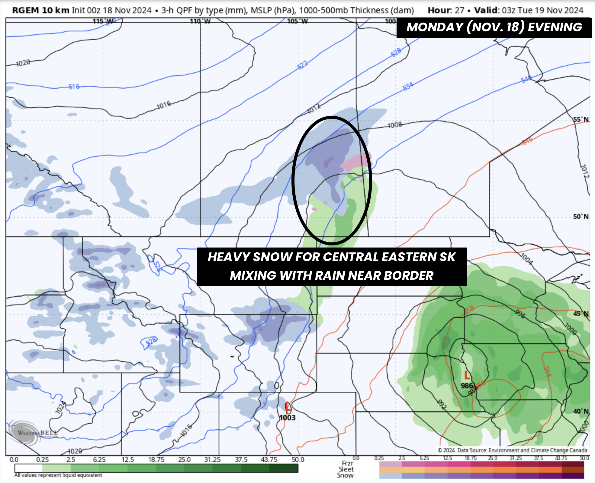
PRECIPITATION TYPE - MAP FROM WEATHERBELL
The storm will begin in Saskatchewan late Monday afternoon or evening, as precipitation moves into the province from the south. The first round of snowfall will primarily impact Central and Northeastern Saskatchewan, with areas like Prince Albert and Nipawin expected to see the heaviest snow through late Monday.
Overnight Monday into early Tuesday, precipitation in Saskatchewan will merge with an approaching system from the south, targeting Manitoba. The exact track of this system remains uncertain, but it’s expected to bring significant precipitation to Manitoba throughout Tuesday.
PRECIPITATION TYPE - MAP FROM WEATHERBELL
Initially, much of Eastern Manitoba, including Winnipeg, will see heavy rain. By Tuesday late morning or early afternoon, colder air will begin to wrap into the region, creating a risk of freezing rain in parts of Southwestern Manitoba, including Brandon and Portage la Prairie.
Meanwhile, heavy snow will persist across Eastern Saskatchewan, where Arctic air is firmly in place. There is some uncertainty about how far west the precipitation will extend into Saskatchewan, but the heaviest snow is expected closer to the Manitoba border.
PRECIPITATION TYPE - MAP FROM WEATHERBELL
By Tuesday late afternoon, most of Manitoba will transition from rain to snow as colder air overtakes above-freezing temperatures. Heavy snow will continue through the overnight hours into Wednesday morning.
SUSTAINED WIND SPEED - MAP FROM WEATHERBELL
Strong winds, with sustained speeds near 40 km/h and gusts of up to 70 km/h, will develop late Tuesday and persist into much of Wednesday. Combined with heavy snowfall, this will likely lead to blowing snow and blizzard-like conditions, particularly in parts of Eastern Saskatchewan and Western Manitoba.
As the system exits the region later on Wednesday, the snowfall will gradually taper off. However, this storm will usher in the coldest air of the season so far, with temperatures dropping to -10°C to -20°C by the end of the week.
Snowfall Accumulation
Monday
By the end of Monday, snowfall totals are expected to reach 5–10 cm in parts of Central and Eastern Saskatchewan, including Prince Albert, Melfort, and Tisdale. Surrounding areas, such as Saskatoon and Wynyard, could see up to 5 cm of snow.
Tuesday and Wednesday
From Tuesday through Wednesday, snowfall totals are expected to range between 15 and 30 cm across much of the affected region. The heaviest accumulations are anticipated near the Saskatchewan–Manitoba border, where localized totals could exceed 30 cm. Elevation will play a significant role, especially in Western Manitoba, where areas of higher terrain could see as much as 30–40 cm.
In Central and Eastern Manitoba, snowfall amounts are harder to pinpoint, as the transition from rain to snow will dictate final totals. Portage la Prairie could see 15–25 cm, while Winnipeg may only receive 10–15 cm, depending on how long the rain lingers before changing to snow.
A similar uncertainty exists in Saskatchewan, but for a different reason—how far west the moisture will penetrate into the province. Some forecasts keep the heaviest precipitation closer to the Manitoba border, while others push it further west. Regina sits on the edge of the higher accumulation zone, with current estimates suggesting 5–15 cm for the city and surrounding areas.


