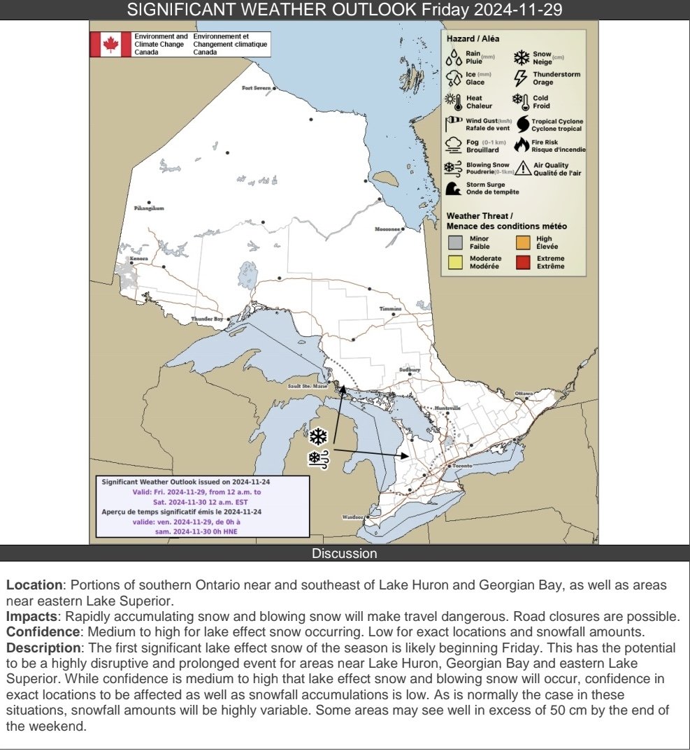
Steep Drop in Temperatures Will Lead to Flash Freeze Risk This Evening and Freezing Rain Into Wednesday

Published: November 14, 2024 - 5:30 PM AT

NOTE: YOU CAN CLICK ON THE MAP TO OPEN A ZOOMABLE IMAGE

It’s been a bit of a weather roller coaster across Southern and Central Alberta over the past several days, with snow and frigid Arctic air late last week to single digit temperatures, melting snow and even some rain falling in the Northern Rockies.

Now, temperatures are expected to plummet later this evening, leading to a risk for a flash freeze along with freezing rain across a swath of the province continuing throughout the day tomorrow.


Warm temperatures across Central and Southern Alberta in the single digits have resulted in the melting of some of the existing snowpack. On top of this, precipitation has already begun to push into the Northern Rockies region of Alberta from British Columbia as a mix of rain and snow this afternoon.

As the precipitation pushes deeper into the province and temperatures quickly fall to just below the freezing mark this evening, not only will the melted snow and slush rapidly freeze, the rain will also transition over to freezing rain, creating very icy conditions. This patch of freezing rain will remain fairly stationary around Grande Prairie into Wednesday morning, leading to ice accretions up to 5mm. At this point, the entire system will begin to push southeastward across the province, bringing light freezing rain along a narrow track throughout the day, adding to the already icy conditions expected from the flash freeze.

To the north of this freezing rain, where temperatures will be slightly cooler, light snow is expected to fall. Snowfall accumulations will also be limited with this system and a widespread 5-10cm is expected.

Winter Roars Into Ontario This Week With Freezing Rain Threat; Snow Squalls Could Dump Up to 50cm of Snow

NOTE: YOU CAN CLICK ON THE MAP TO OPEN A ZOOMABLE IMAGE

While winter has gotten off to a slow start across Southern Ontario, with many areas only seeing their first snowfall within the past week or two, it seems that change is on the way. November is shaping up to go out like a lion, as Mother Nature makes up for lost time.


A significant pattern shift is expected to bring the threat of freezing rain late Monday across Central and Eastern Ontario. This will be followed by multiple weaker systems across the Great Lakes region and colder air flooding into the province.

That colder air will set the stage for what could become our first major snow squall event later this week and into the weekend. In some typical snowbelt areas, snowfall could be measured in feet (30+ cm) by this time next week!

Let’s break down what is shaping up to be a very dynamic and active forecast over the next five to seven days, starting with the freezing rain threat.


Freezing Rain Risk: Monday into Tuesday

PRECIPITATION TYPE - MAP FROM WEATHERBELL

A system is expected to move into Southwestern Ontario and the Golden Horseshoe beginning Monday afternoon. With temperatures forecasted to stay well above freezing in these areas, precipitation will fall as rain.

However, as the system moves northeast into Central and Eastern Ontario after midnight, it will encounter a stubborn layer of colder air near the surface. Temperatures hovering near or just below freezing may allow some of the rain to fall as freezing rain overnight into early Tuesday morning.


There remains some uncertainty about how widespread this pocket of cold air will be. Higher-elevation areas of Central and Eastern Ontario, including Bancroft, Barry’s Bay, and Algonquin Park, are most likely to experience freezing rain. It’s also possible for freezing rain to extend westward to Muskoka and Parry Sound, and eastward into the Ottawa Valley, including the City of Ottawa.

For Bancroft, Barry’s Bay, and Algonquin Park, ice accretion totals could reach 2-4 mm by Tuesday morning, though any ice will quickly melt after sunrise as temperatures rise above freezing by late morning. In Muskoka and the Ottawa Valley, a thin layer of ice on untreated surfaces is possible, which could make for a slow Tuesday morning commute. There is a slight chance of school bus cancellations in affected areas.


Northern Ontario: Heavy Snowfall Ahead

NOTE: YOU CAN CLICK ON THE MAP TO OPEN A ZOOMABLE IMAGE

Northern Ontario will experience heavy snow from this same system, as colder air dominates in the region. Light to moderate snowfall is expected to begin in Northwestern Ontario by early Monday afternoon, gradually spreading eastward into the evening and overnight.

Snow will continue across Northern Ontario throughout Tuesday, with the heaviest snowfall expected near the Quebec border in Northeastern Ontario. Snowfall will gradually ease later on Tuesday and into early Wednesday but could persist near James Bay in a zone extending from Hearst to Lansdowne House.


Over three days, snowfall totals will generally range from 10 to 20 cm across Northern Ontario. Far Northern Ontario near James Bay could see totals exceeding 20 cm by Thursday, while lake-enhanced snowfall southeast of Lake Superior, including Sault Ste. Marie, could push totals closer to 30 cm.

Thunder Bay is expected to see slightly less snow, as the city may end up in a drier part of the system. Forecasts currently suggest snowfall amounts of 5 to 10 cm in this area.


Southern Ontario: Cold Air and Lake Effect Snow

PRECIPITATION TYPE - MAP FROM WEATHERBELL

As the system moves out of Southern Ontario late Tuesday, a surge of cold air will follow in its wake. This will briefly activate the lake effect snow machine around Lake Huron and Georgian Bay beginning Tuesday evening and lasting into Wednesday.


NOTE: YOU CAN CLICK ON THE MAP TO OPEN A ZOOMABLE IMAGE

At this time, temperatures are expected to hover near the freezing mark, which could limit significant accumulation. The most likely target zone for this initial burst of lake effect snow includes areas east of Georgian Bay, such as Parry Sound, Huntsville, and Bracebridge. These areas could see 10-15 cm, with localized amounts of up to 20 cm by the time snow bands taper off Wednesday evening.

For higher elevations southeast of Owen Sound, including Hanover, Markdale, Shelburne, and Orangeville, up to 5-10 cm of snow is possible, as cooler temperatures in these areas will allow snow to accumulate more easily. Surrounding regions, including parts of the Greater Toronto Area, may see just a few light flurries.


End of the Week: A Snow Squall Event Looms

NOTE: YOU CAN CLICK ON THE MAP TO OPEN A ZOOMABLE IMAGE

Lake effect snow will temporarily pause as another system slides through the Great Lakes region. However, this system appears to stay largely south of the border, bringing only a few flurries or light showers to areas near Lake Erie and the Golden Horseshoe early Thursday.

As we approach the weekend, Southern Ontario will see its coldest air of the season so far, with overnight lows plunging to several degrees below freezing across much of the province.


A dominant westerly to northwesterly wind is expected to develop Friday and persist into the weekend. This setup will create ideal conditions for intense snow squalls off Lake Huron, Lake Superior, and Georgian Bay starting Friday afternoon and lasting through the weekend.

These snow squalls could bring significant snowfall totals, blowing snow, and near-zero visibility to localized areas in the snowbelt. Travel could become difficult or even dangerous in the hardest-hit regions.

Based on the current forecasted wind direction, regions including Kincardine, Owen Sound, Hanover, Midland, Oro, Orillia, and Gravenhurst are likely to see the heaviest impacts. This also extends up into Northern Ontario around the Lake Superior shoreline with Sault Ste. Marie in the bullseye. Some locations within this zone could receive up to 50 cm of snow by the end of the weekend.


Snow Squall Uncertainty

It’s important to note that snow squalls are highly localized events, and not everyone will experience intense snowfall totals. One area may receive significant snow accumulations, while locations just a few kilometres away might see only a dusting.

Confidence is high that some sort of snow squall event will occur, but exact locations will depend on the finer details of wind direction and temperatures.

CREDIT: Environment CANADA

Environment Canada has also mentioned the potential for significant snow squalls later this week:

The first significant lake effect snow of the season is likely beginning Friday. This has the potential to be a highly disruptive and prolonged event for areas near Lake Huron, Georgian Bay and eastern Lake Superior. While confidence is medium to high that lake effect snow and blowing snow will occur, confidence in exact locations to be affected as well as snowfall accumulations is low. As is normally the case in these situations, snowfall amounts will be highly variable. Some areas may see well in excess of 50 cm by the end of the weekend. - Environment Canada

Stay tuned for updated forecasts in the coming days as higher-resolution models provide more details. We’ll refine the snow squall forecast and pinpoint areas most at risk.


Retrograding Storm Will Bring a Freezing Rain Threat To New Brunswick Friday

NOTE: YOU CAN CLICK ON THE MAP TO OPEN A ZOOMABLE IMAGE

It’s been an extended wet stretch through the Maritimes lately and that pattern is set to continue over the next couple of days. A low pressure system that has been bringing heavy rain and strong winds to Newfoundland has begun to retrograde and travel westward towards the Maritimes, where it is expected to bring even more rain to the already soggy region starting later tonight.


Most of the Maritimes can expect steady rain, that could be heavy at times, throughout the day Friday and into Saturday, with a widespread 5-30mm falling across the region and up to 50mm possible in the Cape Breton Highlands.

The leading edge of this storm, however, will encounter cool air over land in New Brunswick, with temperatures hovering around 0°C or just below, resulting in freezing rain falling for up to several hours. The freezing rain will begin in the early morning hours and gradually spread westward throughout the morning. As temperatures climb throughout the day, the freezing rain will transition to rain, but surfaces will still be quite slick with a thin layer of ice.

Up to 2mm of ice accretion can be expected across most of the province and closer to 4mm could be seen in the northwest where the cooler air will persist, leading to 4-6 hours of freezing rain. Areas along the eastern coast look like they will be spared from the freezing rain since temperatures are expected to stay a few degrees above freezing overnight. Make sure to take extra caution when travelling along icy roads and sidewalks tomorrow morning.