

Spotting Outflow Boundaries in IW Pro
/If you've ever noticed a thin line on radar racing away from a thunderstorm, you may have been looking at an outflow boundary.
Unlike rain or hail, an outflow boundary isn't precipitation. Instead, it's the leading edge of cooler air spreading outward from a thunderstorm. Once you know what to look for, you'll start noticing them on radar more often and they can provide valuable clues about how storms are evolving.
What Is an Outflow Boundary?
As rain falls through a thunderstorm, it drags cooler air toward the ground. When this cooler, denser air reaches the surface, it spreads outward in all directions, much like ripples created when a stone is dropped into water.
The leading edge of this spreading air is called an outflow boundary.
As it moves, it can lift the warm, humid air ahead of it. Sometimes this simply creates a wind shift and a drop in temperature. Other times, if the atmosphere is unstable enough, it can help trigger new thunderstorms.
How Does It Look on Radar?
Outflow boundaries often appear as a thin, narrow line of weak reflectivity extending away from a thunderstorm.
Unlike the heavy precipitation behind it, the boundary itself usually produces little or no rain. Instead, the radar is detecting tiny particles, insects, dust, or other objects being concentrated along the leading edge of the moving air.
Depending on atmospheric conditions, outflow boundaries can sometimes be very easy to see, while at other times they may be faint or not visible at all.
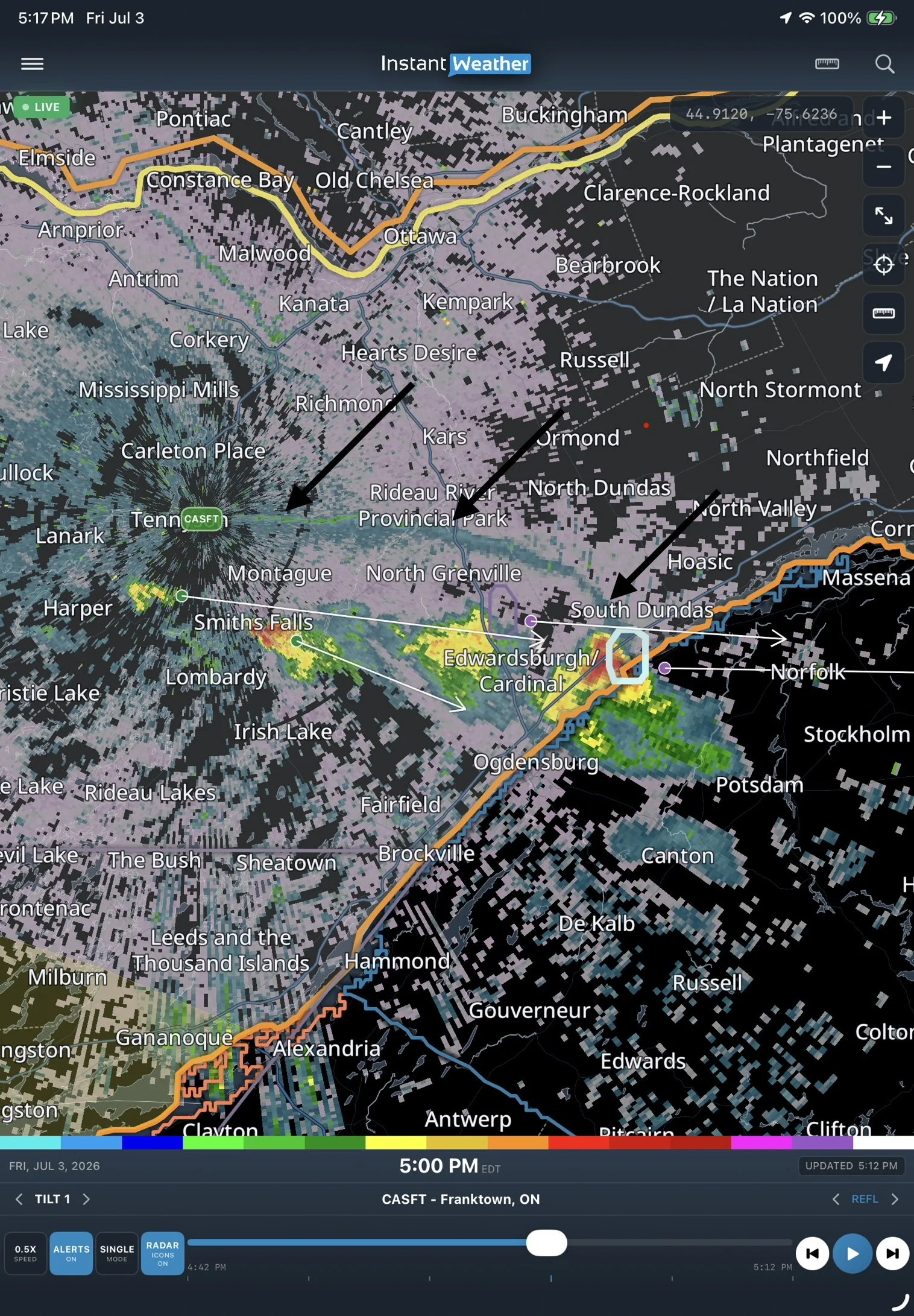
Watching It Move
A single radar image can sometimes make an outflow boundary difficult to identify. Comparing two radar images taken a few minutes apart makes it much easier to see.
In the examples below, notice how the thin line has moved outward away from the parent thunderstorm. While the rain remains concentrated near the storm, the outflow boundary continues to spread ahead of it.
By stepping through successive radar frames in IW Pro, you'll often see this outward movement very clearly, making outflow boundaries much easier to recognize.
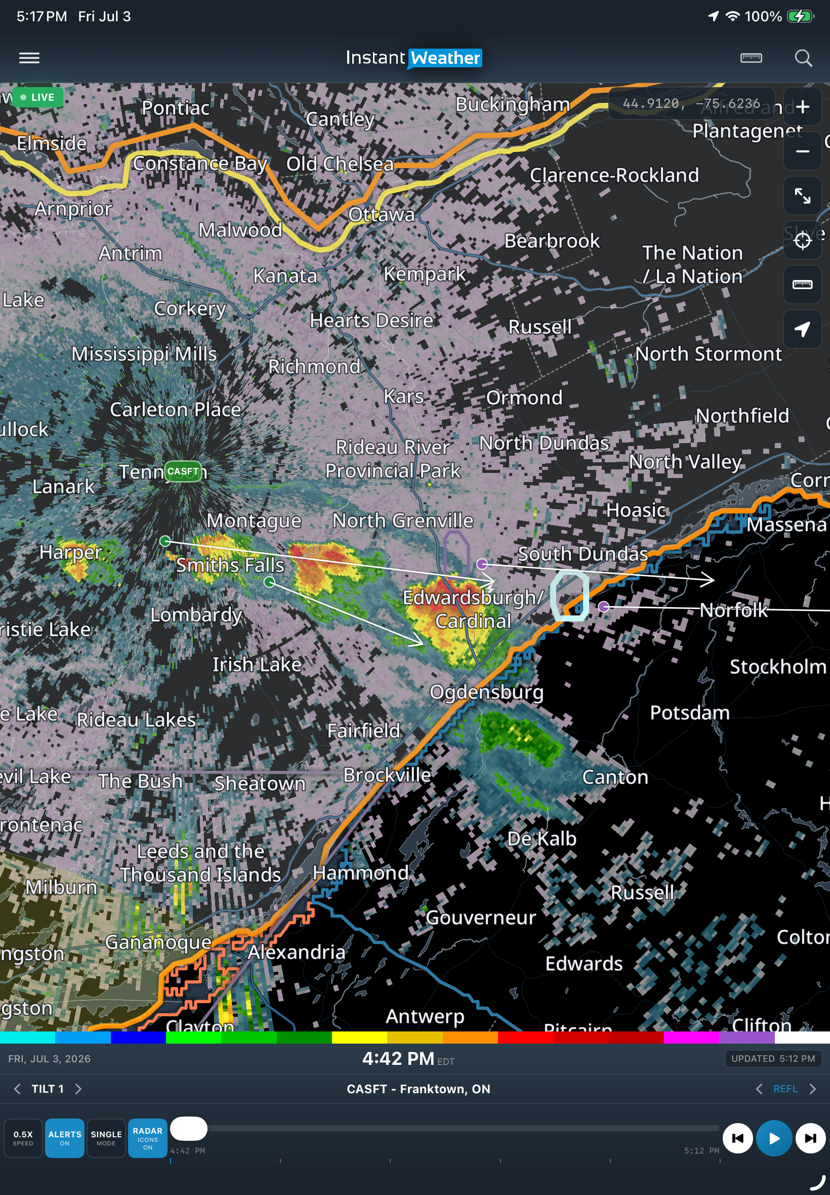
An outflow boundary appears as a thin line of weak reflectivity extending away from the thunderstorm.
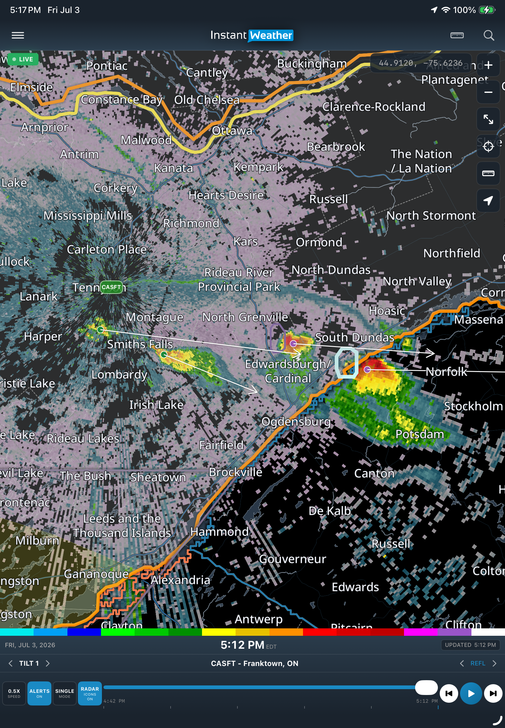
A few minutes later, the boundary has continued moving outward while the main area of precipitation remains behind it.
Why Do Meteorologists Watch Them?
Outflow boundaries can provide valuable information about what storms are doing and what they might do next.
They can:
Mark the arrival of cooler air and gusty winds.
Cause a noticeable wind shift at the surface.
Lead to a rapid drop in temperature.
Trigger new thunderstorms when they lift warm, humid air.
Occasionally enhance low-level rotation if another thunderstorm later moves across the boundary and the rest of the environment is favourable.
An outflow boundary alone does not mean severe weather is imminent, but it is one of many features meteorologists monitor when assessing storm evolution.
Spotting Outflow Boundaries in IW Pro
As you're watching radar in IW Pro, look for:
A thin line extending outward from an existing thunderstorm.
A feature moving away from the storm over successive radar frames.
A boundary that often travels faster than the precipitation itself.
New showers or thunderstorms that sometimes develop along the boundary later in the day.
These subtle features can be easier to recognize by animating the radar rather than viewing a single frame.
Final Thoughts
Outflow boundaries are one of many fascinating features that weather radar can reveal. While most people use radar simply to see where it's raining, learning to recognize features like outflow boundaries can help you better understand how thunderstorms evolve and why new storms sometimes develop seemingly out of nowhere.
The more you compare successive radar frames in IW Pro, the easier these subtle features become to recognize. Before long, you'll find yourself spotting outflow boundaries on many thunderstorm days.
-
Examples
- Jul 8, 2026 Spotting Outflow Boundaries in IW Pro Jul 8, 2026
- Jul 23, 2023 Hail spike example Jul 23, 2023
- Jul 22, 2023 Example of bow echo-type storm with counter-rotating vortices Jul 22, 2023
-
Features
- Aug 18, 2026 Understanding Weather Fronts in IW Pro Aug 18, 2026
- Jun 27, 2026 Understanding Storm Relative Velocity (SRV) in IW Pro Jun 27, 2026
- Mar 23, 2026 Weather Alerts in IW Pro: More Control Than Ever Mar 23, 2026
- Mar 23, 2026 Canadian Radar Outages Now Available in IW Pro Mar 23, 2026
- Feb 28, 2025 🛠️ IW Pro Settings Overview (last reviewed May 2025) Feb 28, 2025
- Feb 28, 2025 Environment Canada's "Thunderstorm Outlooks" Feb 28, 2025
- Aug 26, 2024 Listing and full description of alerts Aug 26, 2024
- Aug 26, 2024 IW StormRisk storm track arrows and colour key Aug 26, 2024
- Jul 30, 2024 IW StormRisk is live Jul 30, 2024
- Jul 10, 2024 U.S. alerts Jul 10, 2024
- Jul 10, 2024 Mosaic Radar Layer Jul 10, 2024
- Jul 10, 2024 IW StormRisk preview Jul 10, 2024
- Sep 9, 2023 Measurement tool in single mode Sep 9, 2023
- Jul 24, 2023 🛠️ Requested Features (Updated May 2025) Jul 24, 2023
- Jul 17, 2023 Canadian Alerts Jul 17, 2023
-
Getting Started
- Jul 9, 2026 Getting Started with IW Pro Jul 9, 2026
- May 20, 2025 Introduction to Instant Weather Pro May 20, 2025
- Jul 23, 2023 White screen on mobile - Update Aug 15 Jul 23, 2023
-
How-to
- Mar 23, 2026 How to Update the Credit Card Linked to Your IW Pro or TMA Subscription Mar 23, 2026
- Sep 6, 2023 Adding IW Pro to your Home Screen Sep 6, 2023
- Jul 22, 2023 How to read radar Jul 22, 2023
- Jul 22, 2023 Live Mode vs Regular Mode vs Historical Mode Jul 22, 2023
-
News
- Mar 23, 2026 Weather Alerts in IW Pro: More Control Than Ever Mar 23, 2026
- Mar 23, 2026 Canadian Radar Outages Now Available in IW Pro Mar 23, 2026
- Sep 9, 2023 Measurement tool in single mode Sep 9, 2023
- Sep 9, 2023 Improved experience for Android mobile users Sep 9, 2023
- Sep 6, 2023 Recent Improvements as of Sept 6 Sep 6, 2023
-
Resources
- Jun 24, 2025 🌪️ Tornadoes, Downbursts, and Microbursts: What’s the Difference and How to Spot Them on Radar Jun 24, 2025
- Jul 24, 2023 The Anatomy of the Life of a Supercell Jul 24, 2023
-
Troubleshooting
- Sep 9, 2023 Improved experience for Android mobile users Sep 9, 2023
- Sep 6, 2023 Adding IW Pro to your Home Screen Sep 6, 2023
- Jul 24, 2023 Tip for map on mobile devices Jul 24, 2023
- Jul 23, 2023 White screen on mobile - Update Aug 15 Jul 23, 2023
