High Impact Winter Storm on the Way for Southern Ontario Starting Wednesday With Up to 40cm of Snow & Freezing Rain
/
NOTE: YOU CAN CLICK ON THE MAP TO OPEN A ZOOMABLE IMAGE
Confidence is growing that Southern Ontario is on track for what could be the most widespread and significant winter storm of the season so far. That said, there hasn’t been much competition in that regard, as most of this winter’s snowfall has come from localized snow squalls. However, a shift in the weather pattern has placed the region in an active storm track, and Mother Nature isn’t wasting any time delivering a disruptive winter storm right in the middle of the week.
Earlier, there was some uncertainty regarding the exact track of the system, which would have influenced snowfall amounts in different areas. However, in the past 24 hours, forecast models have begun to align on a more consistent storm track. Interestingly, the latest data supports what we initially projected, meaning there hasn’t been a major shift in the forecast.
Widespread snowfall accumulations of 20 to 40 cm are expected from Southwestern Ontario through Central Ontario and into the Ottawa Valley between Wednesday and Thursday. In the Golden Horseshoe and Deep Southwestern Ontario, precipitation will likely begin as snow, but there is potential for ice pellets, freezing rain, or even regular rain to mix in. This could limit snowfall totals, especially along the shorelines of Lake Ontario and Lake Erie, where temperatures may hover near the freezing mark.
For the Greater Toronto Area (GTA), the extent of mixing remains a key uncertainty. It could go either way. Right now, we’re forecasting 10 to 20 cm of snow, but if the mixing line stays south, snowfall amounts could surpass expectations, reaching 25 to 30 cm.
In Deep Southwestern Ontario, including Windsor, Chatham, and extending into the Niagara region, models suggest several hours of freezing rain Wednesday evening and overnight. Some localized areas could see ice accretion of 2 to 5 mm, leading to slippery, untreated surfaces and hazardous road conditions.

PRECIPITATION TYPE - MAP FROM WEATHERBELL
The storm is expected to arrive Wednesday afternoon, with scattered precipitation moving into Southwestern Ontario between 2 and 4 PM. While most areas will initially see snow, some models are aggressive in bringing freezing rain into Windsor and Chatham by late afternoon.
Before the main storm arrives, lake-effect snow may develop off Lake Ontario, affecting the Burlington and Hamilton corridor Wednesday morning into early afternoon. System snow should reach the GTA just before the evening rush hour, making for a difficult commute.
The latest model data has also increased wind projections, with gusts of 40 to 60 km/h in some areas. Combined with heavy snowfall, this could lead to blowing snow and reduced visibility. Non-essential travel should be avoided starting in the late afternoon, with conditions deteriorating further into the evening.
PRECIPITATION TYPE - MAP FROM WEATHERBELL
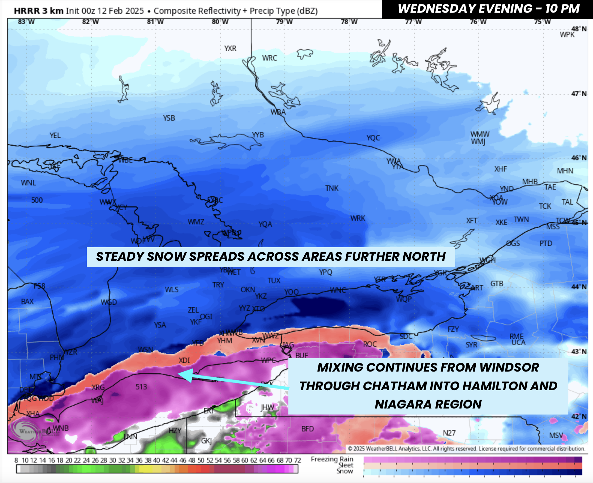
By mid to late evening, snow will have spread across most of Southern Ontario, including Central and Eastern Ontario. A key feature to monitor will be the movement of the mixing line.
Current data shows a freezing rain corridor stretching from Leamington through Chatham and along the Lake Erie shoreline, with a narrow band of ice pellets from Windsor through just south of London and into Hamilton.
Meanwhile, heavy snow will persist across Sarnia, London, Kitchener, and the GTA. Snowfall rates will intensify after 9–10 PM, increasing from 1–2 cm per hour to 2–4 cm per hour. This will make it challenging for snowplows to keep up.

PRECIPITATION TYPE - MAP FROM WEATHERBELL
After midnight, the mixing line may push north into parts of the GTA, bringing ice pellets and freezing rain to locations such as London, Burlington, Mississauga, and Toronto for several hours. However, this transition looks to be confined near the Lake Ontario shoreline, meaning snowfall will likely dominate farther inland.
Freezing rain will continue across Windsor and along the Lake Erie shoreline into the Niagara region, while heavy snow steadily blankets Central and Eastern Ontario overnight.

PRECIPITATION TYPE - MAP FROM WEATHERBELL
The system will begin its exit Thursday morning, with snow tapering off in Southwestern Ontario first. However, snow will continue across Central and Eastern Ontario.
In the Niagara region and along the Lake Ontario shoreline, mixing will remain a concern into the early morning hours. However, by 4–6 AM, colder air will push in, flipping precipitation back to snow. Any previously fallen precipitation may refreeze as temperatures drop, creating hazardous road conditions.
Expect treacherous travel conditions on Thursday morning. Roads will be slushy and icy in areas that saw mixing, while heavy snow will make roads impassable further north. Widespread school bus cancellations and school closures are likely.

PRECIPITATION TYPE - MAP FROM WEATHERBELL
Eastern Ontario will hold onto light to moderate snow through the late morning. However, models indicate some potential for mixing in the Kingston, Brockville, and Cornwall areas. This could result in light icing from freezing rain before a final transition back to snow.
Most of Southern Ontario will finally see an end to precipitation Thursday, aside from some lingering lake-effect snow near Lake Huron.

NOTE: YOU CAN CLICK ON THE MAP TO OPEN A ZOOMABLE IMAGE
Based on the latest data, the highest snowfall totals will likely be in Central and Eastern Ontario. A widespread 20–40 cm is forecast across Southwestern, Central, and Eastern Ontario. However, totals closer to 40 cm are most probable in Eastern Ontario, including Ottawa, where there’s even a slight chance of locally exceeding 40–50 cm.
Central and Southwestern Ontario, including Grey-Bruce, Kitchener, York Region, Simcoe County, Muskoka, and Peterborough, will likely receive 20–30 cm, with some areas near Lake Simcoe potentially exceeding 30 cm.
The exception will be the Lake Ontario shoreline and the International border, including Kingston, Brockville, and Cornwall. Lower snowfall ratios and a higher risk of mixing could keep totals below 20 cm. However, if mixing remains minimal, this area could exceed forecasts.

NOTE: YOU CAN CLICK ON THE MAP TO OPEN A ZOOMABLE IMAGE
The snowfall forecast becomes more uncertain in Deep Southwestern Ontario and the Golden Horseshoe, where multiple factors create a ‘boom or bust’ scenario. The GTA will start with heavy snow, likely reaching 10 cm fairly easily unless there’s a drastic shift in the storm track. The big question is how much more accumulates beyond that.
Some models suggest that if mixing does not occur, parts of the GTA could see 20–30 cm by Thursday morning. However, given the likelihood of overnight mixing, we expect totals to stay below 20 cm, which is why our official forecast remains at 10–20 cm.
London and Sarnia sit on the boundary between significant snow and mixed precipitation. The most probable outcome is 15–20 cm, though an overperformance remains possible.

NOTE: YOU CAN CLICK ON THE MAP TO OPEN A ZOOMABLE IMAGE
In Deep Southwestern Ontario and the Niagara region, snowfall amounts will be lower, with less than 10 cm expected. However, these areas will likely see prolonged freezing rain, with the heaviest ice accretion along the Lake Erie shoreline.
Models vary on how intense the freezing rain will be. Some project as much as 10 mm of ice accretion, but this seems unlikely given the presence of mixed precipitation and the relatively short duration of freezing rain. Our official forecast calls for 2–5 mm of ice accretion, though isolated pockets could see 7–10 mm if freezing rain persists longer than expected.


