Snowy One-Two Punch Targets Southern Ontario Starting Wednesday as Alberta Clipper and Squalls Dump Up to 25 to 50 cm of Snow
/
NOTE: YOU CAN CLICK ON THE MAP TO OPEN A ZOOMABLE IMAGE
The story of the week so far across Southern Ontario has been the relentless snow squall activity that has been hammering the region, bringing treacherous travel conditions as a surge of Arctic air continues to sit overhead. These squalls have been anything but minor, producing frequent whiteouts, rapidly deteriorating road conditions, and dangerous travel at times.
The worst of the impacts on Tuesday was when intense snow squalls forced the closure of multiple stretches of Hwy 11 between Bracebridge and Orillia. Whiteout conditions combined with rapidly accumulating snow led to several accidents, leaving many drivers stranded and highlighting just how dangerous these squalls can become when they lock into place.
While the snow squalls are far from finished, the threat zone is expected to shift over the next few days as winds gradually turn more westerly. This change in wind direction will push the most persistent squall activity away from areas that were hit earlier this week and refocus it further west and north.
As a result, locations such as the Bruce Peninsula, Muskoka, Parry Sound, and even areas further inland like Haliburton and Bancroft are expected to see the most significant impacts through the second half of the week.
Snow squall activity will briefly weaken during the day on Wednesday, but this will not be because the atmosphere is calming down. Instead, an Alberta Clipper is expected to move into Southern Ontario beginning Wednesday morning, temporarily disrupting the lake effect setup.
This clipper will spread a shield of steady light to moderate snow across Southwestern Ontario, extending through the Golden Horseshoe and into Eastern Ontario as the day goes on. While this system is not expected to produce extreme snowfall amounts on its own, it will still have notable impacts due to its timing and the already poor road conditions in many areas.
Compared to the storm some locations experienced last week, snowfall totals with this system will be more modest. However, the combination of falling snow, reduced visibility, and slick road surfaces could still make both the morning and evening commute hazardous in spots.
At this point, we are expecting a general 5 to 10 cm from the Alberta Clipper. As is typical with these systems, snowfall will not be uniform. Alberta Clippers are often moisture-starved, which can lead to dry pockets where snowfall totals underperform, while narrow bands of heavier snow can locally boost amounts closer to 15 cm.
Hourly snowfall rates (cm) - MAP FROM WEATHERBELL
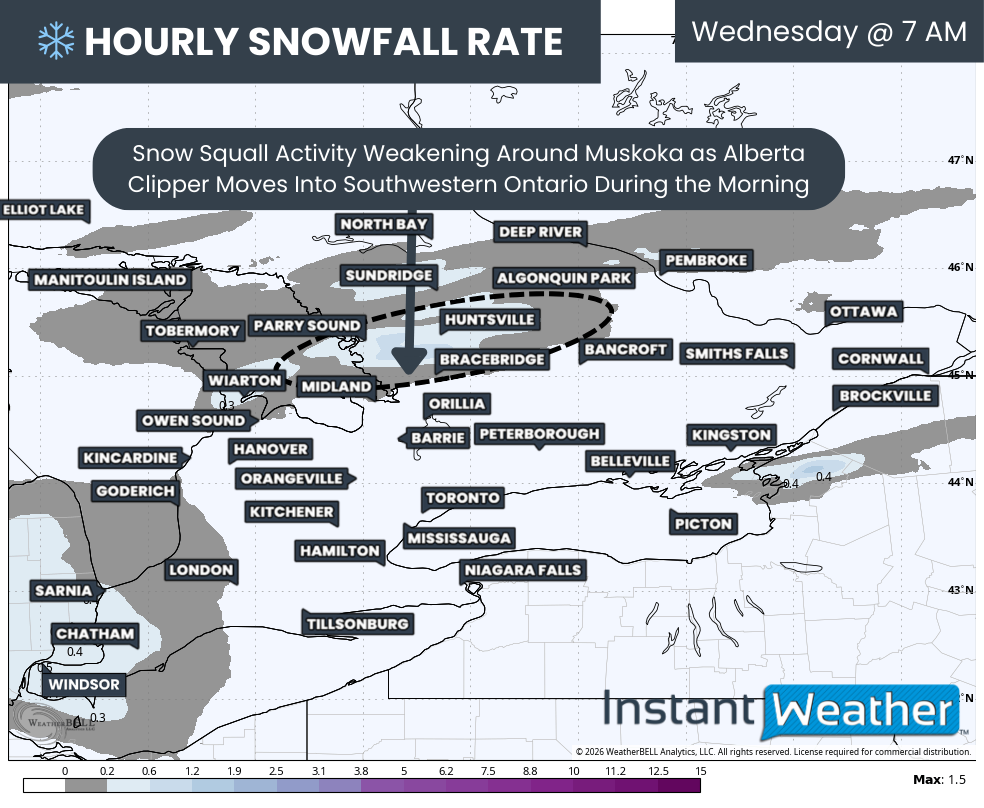
Snow squalls that are already developed east of Georgian Bay will continue to impact the Parry Sound and Muskoka region through the overnight hours and into Wednesday morning. Travel conditions in these areas will remain poor early in the day, especially where bands remain persistent.
As the clipper approaches, winds will begin to shift by mid-morning, weakening the squalls and temporarily shutting down the lake effect snow machine. This will offer a short-lived improvement in conditions for areas east of Georgian Bay before the next phase of the pattern kicks in.
The outer bands of snow associated with the Alberta Clipper will begin to move into Deep Southwestern Ontario around sunrise, affecting areas such as Windsor, Sarnia, and Chatham. From there, the snow will steadily expand northeastward through the late morning hours.
Hourly snowfall rates (cm) - MAP FROM WEATHERBELL
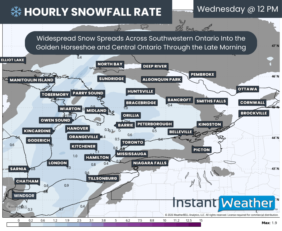
By midday, snow will be falling across much of Southwestern Ontario and into the Golden Horseshoe and Central Ontario. Snowfall rates are not expected to be overly intense, generally topping out around 1-2 cm per hour, but wind gusts of 40 to 60 km/h could still lead to areas of blowing snow and reduced visibility.
Model guidance is also hinting at the development of a dry slot north of the GTA, particularly around Lake Simcoe. This includes areas such as Collingwood, Barrie, and parts of York Region, where snowfall rates could be noticeably lower.
This is a common issue with Alberta Clippers. While the Great Lakes can often help enhance snowfall by adding moisture, regions around Lake Simcoe may miss out when winds are predominantly southerly. In this setup, they sit outside the direct influence of Lake Erie and Lake Ontario moisture feeds.
Hourly snowfall rates (cm) - MAP FROM WEATHERBELL
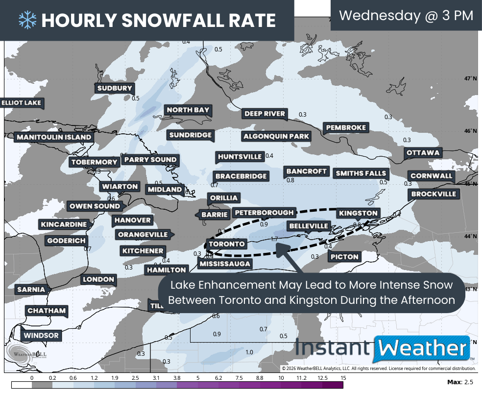
On the flip side, the Toronto to Kingston corridor is expected to benefit from Lake Ontario enhancement. This added moisture could push snowfall totals closer to 10 to 15 cm in this zone, slightly higher than surrounding areas.
This enhanced snowfall is also expected to coincide with the evening commute, particularly along Hwy 401 east of Toronto toward Kingston. Drivers should be prepared for rapidly changing conditions, with visibility dropping quickly at times as heavier bursts of snow move through.
Light snow will also spread into the Ottawa Valley by early afternoon. However, snowfall totals will likely taper off the further north you go as the influence of Lake Ontario weakens. Ottawa itself may only pick up a few centimetres by the time the snow winds down Wednesday evening.
Snow from the clipper is expected to gradually taper off from west to east by the late afternoon or early evening as the system exits Eastern Ontario. Unfortunately, this break will be brief for snowbelt regions.
Hourly snowfall rates (cm) - MAP FROM WEATHERBELL
As the system departs, lake effect snow is expected to rapidly redevelop overnight Wednesday as winds settle into a southwesterly direction. This will allow the lake effect machine to roar back to life.
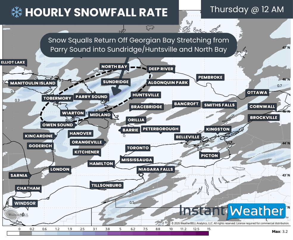
The brunt of the snow squall activity overnight will be focused on the Bruce Peninsula, Parry Sound, and North Muskoka. At times, these squalls could stretch further inland toward areas like Sundridge and even North Bay.
Travel conditions overnight into Thursday are expected to be very poor. Snowfall rates may become intense within the strongest bands, and it is quite possible that sections of Hwy 400 or Hwy 11 could see temporary closures if snow accumulates faster than crews can keep up. Travel in these areas is highly discouraged.
Hourly snowfall rates (cm) - MAP FROM WEATHERBELL
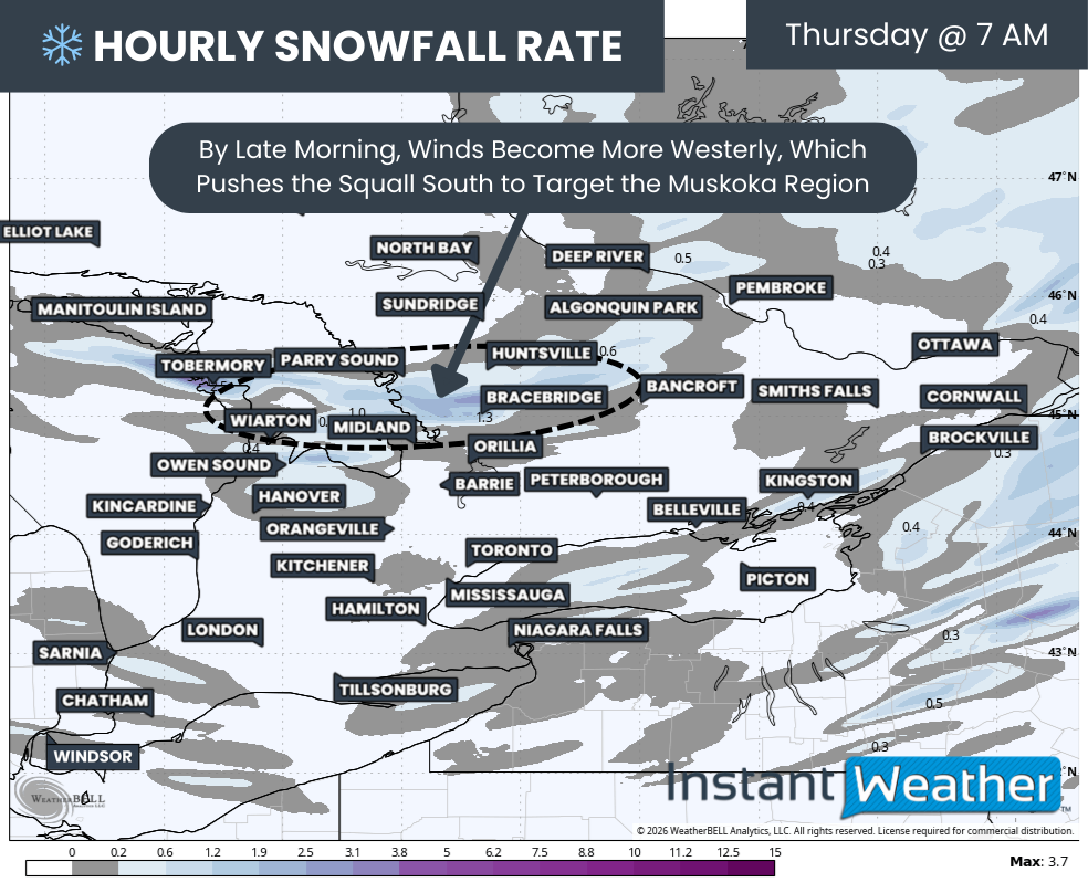
By sunrise Thursday, winds are expected to gradually turn more westerly. This shift will cause the main squall to sink southward into Muskoka, targeting locations such as Bracebridge, Port Carling, Baysville, Port Sydney, Rosseau, and MacTier.
Some model guidance suggests this squall could become nearly stationary through much of the day Thursday. If this scenario verifies, snowfall totals could quickly climb, with some areas potentially exceeding 50 cm by the end of Thursday.
Other models suggest a more oscillating band that shifts north and south throughout the day. While this would limit extreme totals in one single location, it would spread significant snowfall across a broader portion of Muskoka and Parry Sound.
Hourly snowfall rates (cm) - MAP FROM WEATHERBELL
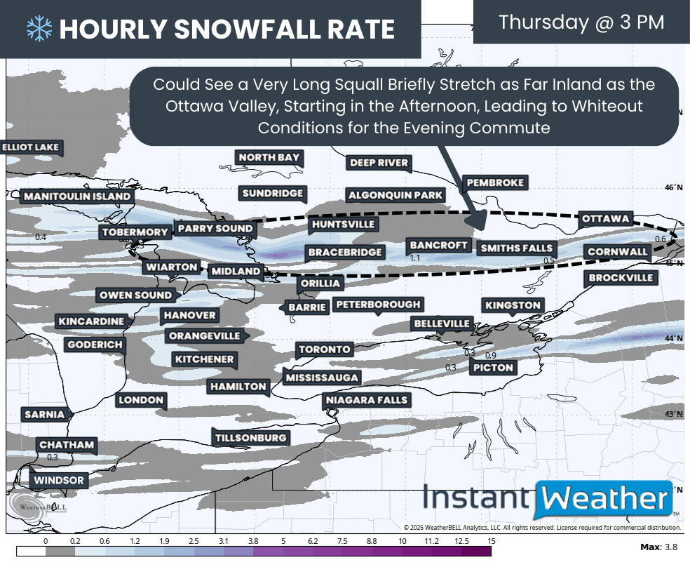
As we head into Thursday afternoon, the impacts of the Georgian Bay squall may extend beyond the typical snowbelt. Strengthening winds could allow the band to push further inland, potentially reaching parts of Eastern Ontario and even the Ottawa Valley.
Locations such as Bancroft, Smiths Falls, Renfrew, and Ottawa could see several hours of heavy snow, leading to sudden whiteout conditions right during the evening commute. These whiteouts can occur with very little warning, making it critical for drivers to remain alert and be ready to adjust their driving immediately.
It could also bring a quick 5-10cm to the Ottawa Valley, which, combined with the Alberta Clipper, puts them in the 5-15cm range despite missing the worst of the clipper.
Additional lake effect snow is also possible east of Lake Huron during the day on Thursday, affecting Grey Bruce, along with parts of Huron and Perth Counties. While models are not showing a well-organized band at this time, wind gusts near 60 km/h could still lead to blowing snow and reduced visibility.
Snow squall activity is likely to persist into Thursday night and possibly into Friday morning. This forecast cuts off at the end of Thursday, with a separate update planned to cover Friday and beyond.

NOTE: YOU CAN CLICK ON THE MAP TO OPEN A ZOOMABLE IMAGE

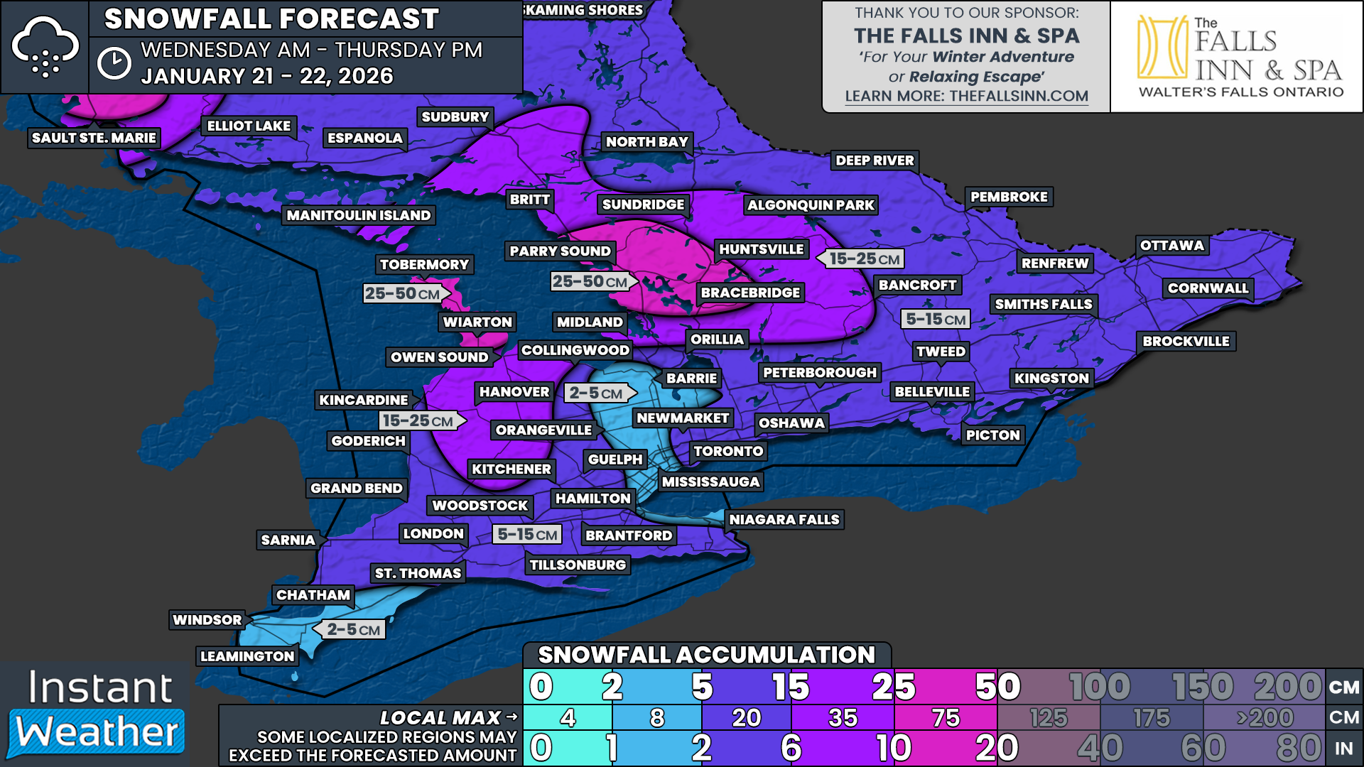
In terms of snowfall totals, most areas away from the lake effect are expected to see around 5 to 10 cm from the Alberta Clipper alone. Some pockets will fall short of that, while others may exceed it slightly, depending on lake enhancement.
That is why regions not expecting lake effect snow are generally placed in the 5 to 15 cm range. This includes much of Eastern Ontario, parts of the eastern GTA, and most of Southwestern Ontario.
Exceptions include areas northwest of the GTA, such as Barrie, Keswick, Bradford, Orangeville, and Angus, as well as Deep Southwestern Ontario, including Windsor, Leamington, and Chatham. These locations are expected to see less moisture and may remain below 5 cm. The same applies to the western GTA and Hamilton.
Once lake effect snow is factored in, totals increase quickly east of Georgian Bay. This includes snowfall from early Wednesday before the clipper arrives and the more intense squalls that follow on Thursday.
Snowfall totals of 25 to 50 cm are expected for the Bruce Peninsula, including Wiarton, Lions Head, and Tobermory, as well as areas east of Georgian Bay such as Bracebridge, Huntsville, and Parry Sound. Muskoka in particular has the potential to exceed 50 cm if the squall becomes stationary on Thursday.
Further south and east, areas such as Midland, Gravenhurst, Minden, Haliburton, and Bancroft can expect around 5 to 10 cm from the system, with an additional 10 to 15 cm from lake effect snow. This puts totals in the 15 to 25 cm range, with locally higher amounts possible.
Southern Grey-Bruce, extending into portions of Huron and Perth Counties, including Owen Sound, Meaford, Hanover, and Listowel, is also expected to end up in the 15 to 25 cm range by the time all is said and done.


