Nova Scotia & Newfoundland! Friday’s Snowstorm Pics Wanted! You Will Get a Chance To Have Them Published!

Issued: January 23rd/24th, 2020 @ 11:50 PM / 12:20 AM

Updated: January 23rd/24th, 2020 @ 11:50 PM / 12:20 AM

Forecaster: James Follette

140608651_3749389715126309_3826819938184319676_o.jpg

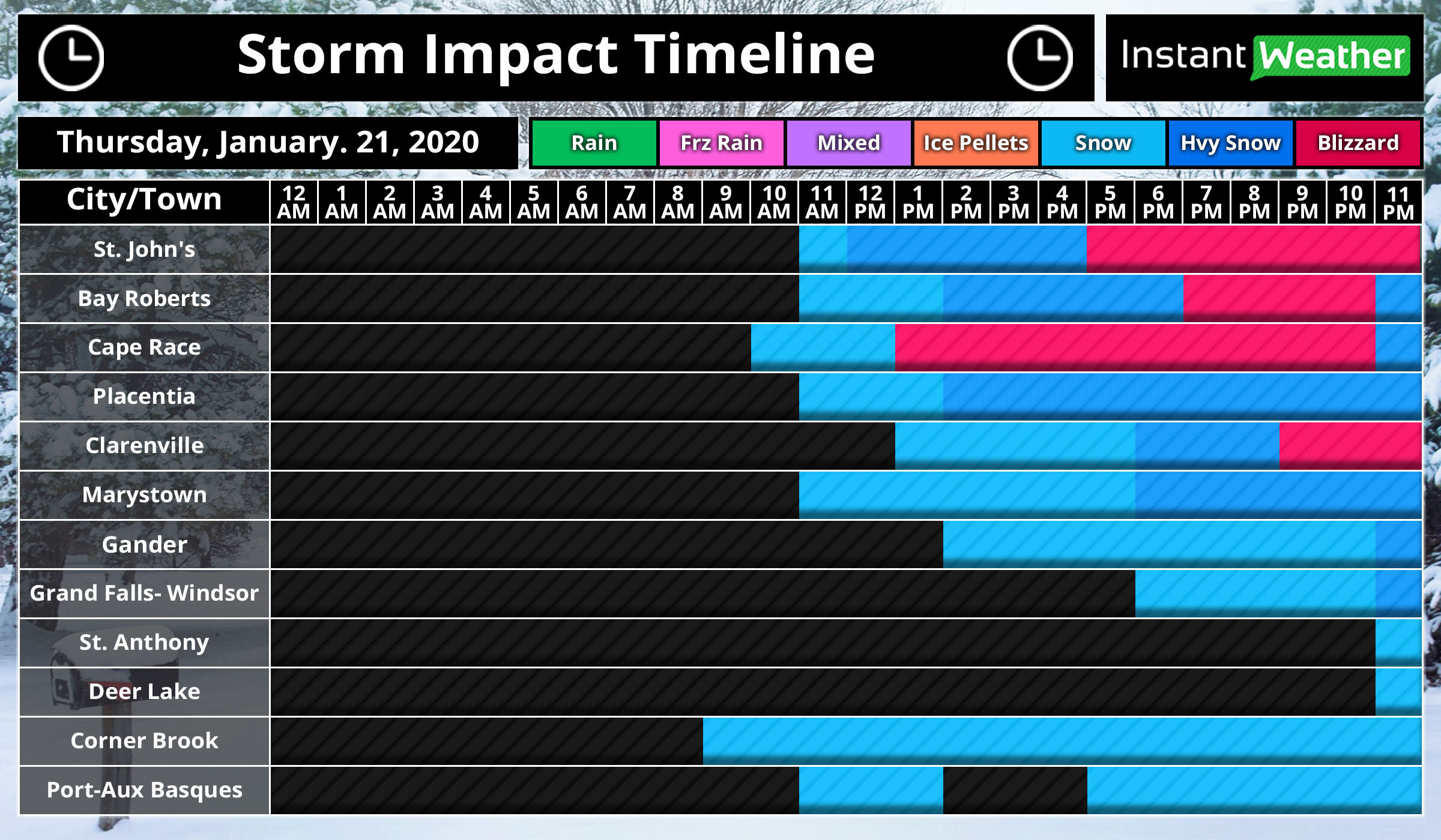
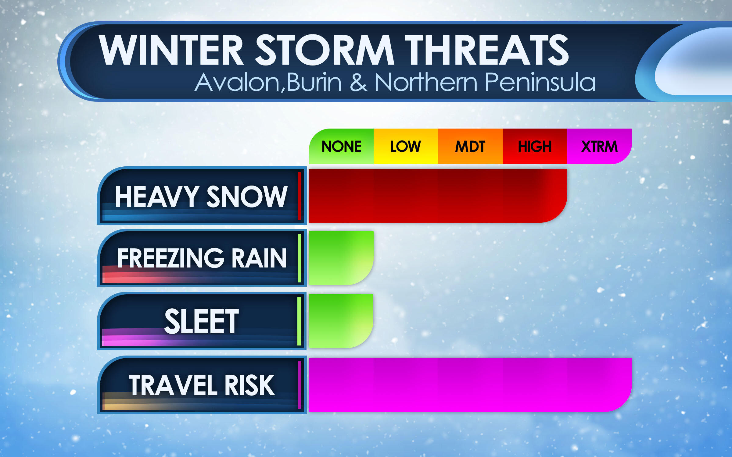
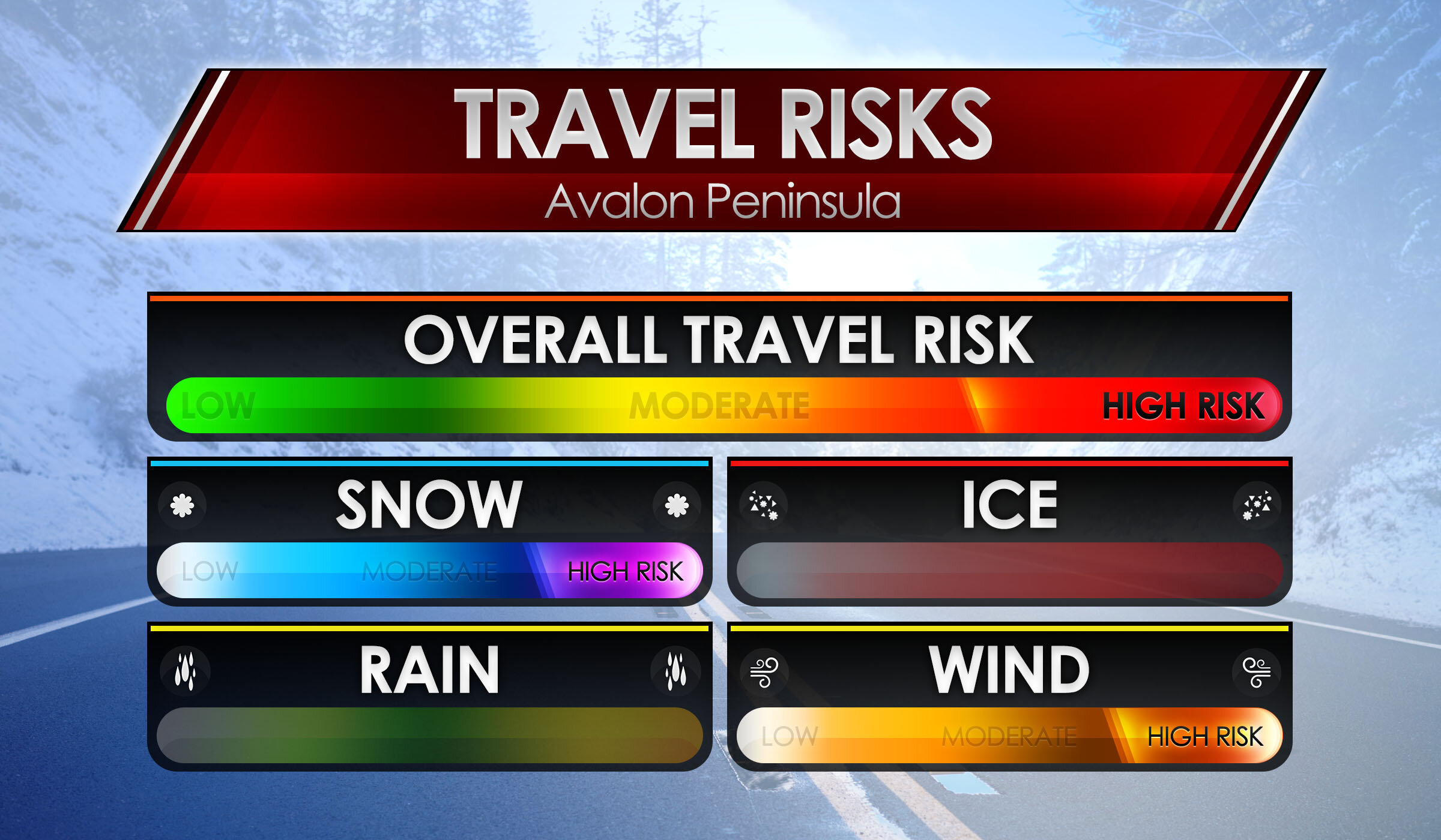
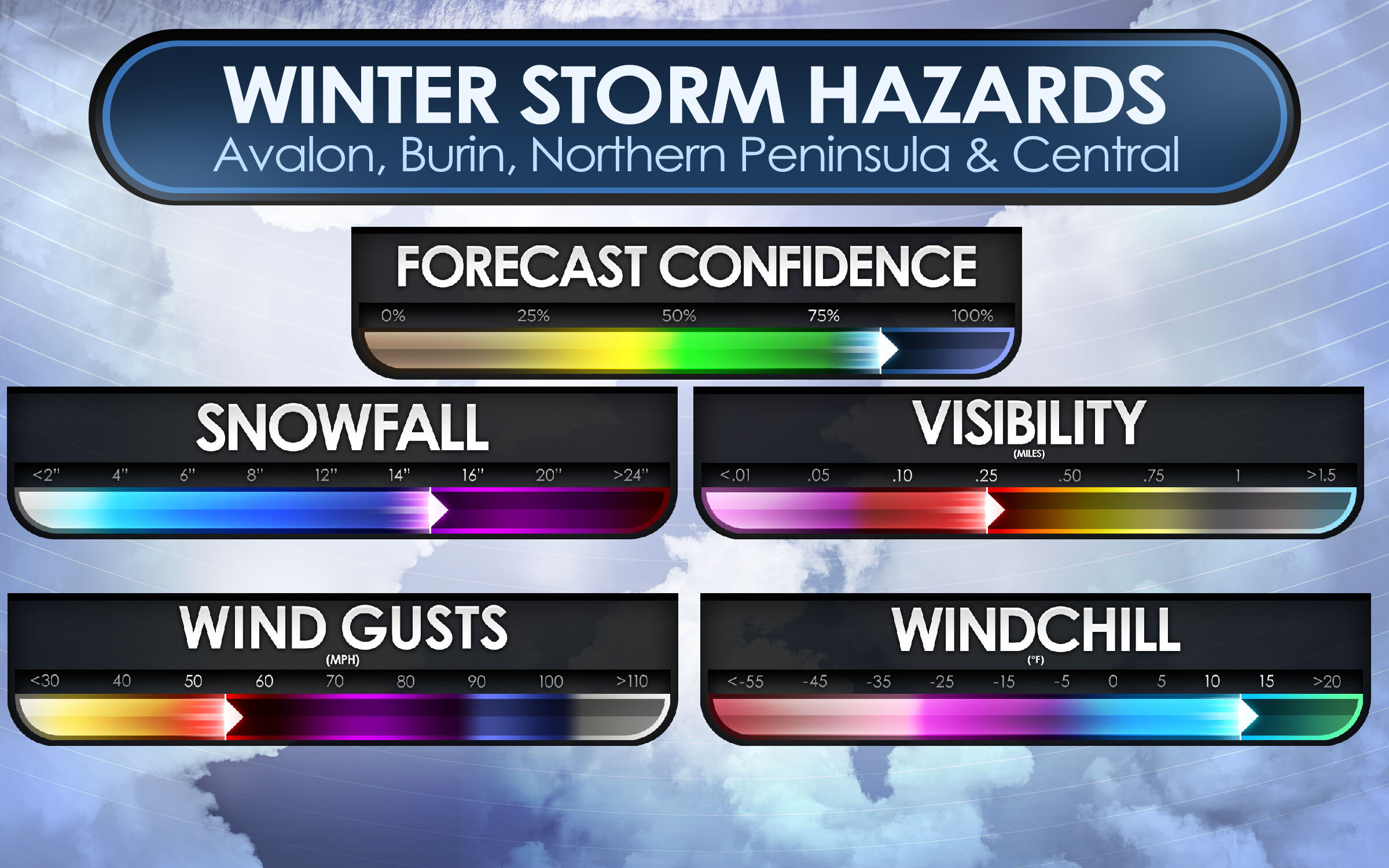
Do you live in Newfoundland or Nova Scotia? and were you in one of the areas that got slammed by Friday’s snowstorm in Nova Scotia and/or the blizzard in Newfoundland?

Have you taken awesome pictures of the storm during or after?

Well, Instant Weather Nova Scotia & Instant Weather Newfoundland would love to see those pictures and publish them on Tomorrow’s storm update! as well as on tomorrow’s forecast updates in the morning & afternoon!

All you have to do, Is go to Instant Weather Nova Scotia or Instant Weather Newfoundland on Facebook! and inbox messages us the pictures with the needed information!

  • Your Name!

  • Your location!

  • If possible, you were able to measure! be great to mention the snowfall measured!

We give credit for this awesome shot!! by Paul Chrisholm! Taken Outbound between Halifax International Airport and Enfield.

Arctic Blast To Bring Intense Snow Squalls to Southern Ontario’s Snowbelts With Up to 50cm of Snow Possible by Saturday

We already got a rude awakening earlier this week with much colder temperatures and some lake effect snow through the snowbelts. That was only the beginning though as another wave of cold Arctic air is expected to push into our region during the day on Friday setting the stage for some strong snow squalls to develop off Lake Huron and Georgian Bay. The lake effect activity will actually begin during the late afternoon on Thursday into the evening hours with a westerly wind pushing heavy snow into the Southern Muskoka and Haliburton area.

This intense squall will deliver a few hours of rapid snowfall accumulation to regions like Port Carling, Bracebridge, Gravenhurst and Minden. Some areas will easily pick up the forecasted 10-20cm within the evening and early overnight hours of Thursday. The blast of cold air will invade the province early Friday morning resulting in a change in the wind direction and shifting the powerful squalls off Georgian Bay southward with an additional band developing off Lake Huron affecting parts of Huron, Perth, Grey and Bruce counties.

Snow squalls off Lake Huron and Georgian Bay will continue throughout the day on Friday with a particularly strong band somewhere between Kincardine and Saugeen Shores. The squall activity off Georgian Bay will be focused on the southeastern shoreline including Collingwood, Angus, Wasaga Beach and Barrie. Although the latest data seems to indicate it won’t be as organized as the squalls off Lake Huron so the snowfall rates will be lower.

Overnight Friday into Saturday morning we’ll see another change in the wind direction to a more northwesterly flow. This will cause the organized band near Kincardine to sink southward and bring heavy snow to areas just to the north of London. It may continue into the afternoon on Saturday before fading out as conditions become unfavourable for lake effect snow.

As far as accumulation, keep in mind that nailing down the exact location of these squalls is tricky and the accumulation will vary significantly depending on where they set up. With that being said, we believe there is a zone that includes Kincardine, Hanover, Mildmay and Minto that has the potential to see as much as 30-50cm of accumulation by the end of day Saturday. Localized amounts may even exceed 50cm should the squall lock into a particular location for an extended period of time. For other regions to the east of Lake Huron, we expect the general 15-30cm of accumulation over the next two days although not everyone will see that.

The lake effect activity off Georgian Bay will first focus on the Muskoka region late Thursday into Friday morning with between 10-20cm of accumulation possible by sunrise Friday. After the squall sinks southward it will bring a few hours of heavy snow to Northern Simcoe County before settling in around the Barrie/Collingwood area. Accumulation for Northern Simcoe County will be around 5-10cm while further south the total accumulation will be closer to 20-30cm. These squalls may stretch into parts of York Region and the Kawartha Lakes especially near Lake Simcoe which could see localized totals between 10-15cm.

We have only shown the affected regions on our map. The rest of Southern Ontario including Eastern Ontario and Extreme Southwestern Ontario will see a few flurries over the next few days with little to no accumulation.

Blizzard To Slam Much of the Island With First Big Snowfall of 2021!

Issued: January. 21, 2021 @ 12:10 PM

Updated: January. 21, 2021 @ 12:10 PM

Forecaster: James Follett

Winter Storm II.jpg

The first big snowstorm of the new year 2021 is now already approaching the province with some light snow and increasing winds, making it look lovely for now, but it’s about to look like a marshmallow world in the city! The heavy snow will quickly move in later this afternoon and evening hours, with the worst conditions between 5pm and 11pm on the Avalon Peninsula, but the moderate snow will continue through the overnight and continue into the early morning with periods of light snow still continuing to fall through the day, and even continue all the way into the weekend!

NFLD Storm Timeline.JPG

The storm has arrived on time right around the noon hour for St. John’s, we will expect that snow to quickly become steadier and heavier as the next few hours go by then it really gets bad by the time we get into the supper hour! Between 5 pm and 11 pm, we could see blizzard conditions!

The further west you go, the later the snow will arrive for you! Gander, Grand Falls- Windsor will see the snow starting later in the afternoon and early evening hours and by the time you reach St. Anthony & Deer Lake, expect the snow to not start until near 11 O’clock tonight!

On and off snow continues today for Corner Brook and Port-Aux-Basques.

Video Block
Double-click here to add a video by URL or embed code. Learn more

As can see by the radar, and futurecast, the snow has already engulfed the entire Avalon Peninsula and will continue to spread north and west through today and tonight as it increases in intensity. You may also notice that when playing the radar, the rain/snow and mix line gets rather fairly close to the southeast near Cape Race. I wouldn’t rule out the possibility of some Freezing rain or Ice pellets in that area later this evening. If it does then snow amounts will likely be a bit lower than forecast and some tweaks to the snow map may be needed.

NFLD Storm Winter storm threats Peninsulas 1.JPG

Here are the main threats with this winter storm, for the Peninsulas of Avalon, Burin and Northern Peninsula. The main threat is the Heavy snow and Travel risk! We are looking at high snowfall rates as much as 5-10cm per hour at times, many models put 40cm for St. John’s and surrounding areas. the heavy snow and combined strong wind gusts of 80-100 km/h will create blizzard conditions which will result in very hazardous travel, and for that reason the Travel Risk is at Extreme.

Central Winter Storm Threats.JPG

For Central areas, The impact is less severe as the storm will be a bit far, and the heaviest snow will miss. However, there still will be a lot of snow and strong gusty winds causing low visibility! a Moderate risk for Heavy snow, but it’s that Travel Risk that is the main Hazard! A very High Hazard, with as much as 15-25cm can fall in that area.

Avalon Peninsula Travel Risk.JPG

Here are the main risks for your travel risks! We’ll start with the Avalon Peninsula as that will be the hardest hit areas! Biggest risks are Snow & Wind, as we are on the colder side of the storm, snowfall amounts as much as 30 to 40cm can fall by Saturday morning! Whipped up by a high risk for winds as winds top 80-100 km/h. This will cause extensive blowing and drifting snow causing extreme low visibilities and Blizzard conditions, Overall Travel risk for the Avalon Peninsula is at High.

Burin, Northern & Central Travel Risk.JPG

We now go to the Burin, Northern Peninsulas and Central for travel risks. High risk again of course for snow! snowfall amounts of up to 25cm possibly more can fall by the weekend. We also will have gusty winds, however the winds will not be as severe as the Avalon, but will be gusty and blowing and drifting snow will still be a factor, but likely not at blizzard condition level. The risk for wind is at Moderate, and that is what the Overall travel risk is, at Moderate.

NFLD Winter Storm Hazards.JPG

As we take a look at Threats and Travel risks, we now go to the Winter Storm Hazards! Main hazards are Snowfall, Visibility, Wind Gusts and for some, wind chill.

Snowfall: For the Avalon Peninsula, a good swath of 30 to 40cm is expected, however extreme western parts of the Avalon may see a little less in the range of 20-30cm. For Burin and Northern Avalon. as much as 10-20cm can fall and up to 30-40cm for the far northern areas. Central can see up to 25cm of snow, but lesser amounts as head south. Overall, snowfall hazards is up to 30-40cm or as much as 14-16”!

Wind Gusts: Strong wind gusts will also accompany this storm! winds of 40-60 sustained will gust to 80 to 100 km/h. this will create some property damage but most of all, the extensive blowing and drifting snow that will create white out conditions at times and blizzard conditions. Winds in the Avalon are expected to reach as high as 80 to 100 on the coast, or 50-60 mph.

Visibility: With the heavy snow and strong wind gusts, there is bound to be very low visibility… which is what is to be expected! visibility of near 0 is expected, and lot’s of times as low at 10 miles for several hours. Blizzard conditions would worsen the visibility, especially in white outs.

Wind chills: With temperatures below 0 and winds expected to clock over 40 sustained, wind chills of -10 to -15 degrees C, is likely and this could lead to a risk of frost bite. and with power outages likely, it’s a good idea to have a generator, or if have wood stove, have extra wood inside! If no generator or stove, have extra blankets and candles to try and keep warm.

NFLD Storm Snowfall map.JPG

Ok, let’s now go over the Forecast maps. We’ll start with the snowfall map. Starting with the Avalon! much of the eastern side will see the most with up to 40cm of snow expected including in the city of St. John’s and down to Cape Race. In the middle there is 20-30cm expected, then as get to the western side of the Avalon Peninsula, you have 12 to 20cm expected with locally up to 25cm that includes for the town of Placentia, Clarenville, and Gander. Blizzard conditions are possible for all of the Avalon Peninsula and including Northern sections from Clarenville to Gander.

For the Burin Peninsula! In the southern parts, such as Fortune and Grand Bank, you can look at only 2-6cm or locally up to 10cm. this is not a big storm for you! head north, however, towards Marystown then you will get into the higher snowfall amounts, of 6 to 12cm with locally as much as 16cm. This also covers much of the central parts of the province including Grand Falls- Windsor.

For Northern Peninsula, 12-20cm expected for Clarenville and even further amounts as head north, with up to a foot expected.

Central: not much snow expected unless going far northern central. expect 2 to 12cm with locally up to 16cm.

Western: Depends where in the west you are, the farther north you go the more snow you will get and the further south, the less you get. Stephenville, Corner Brook, and Deer Lake can see only 2-6cm with locally up to 10cm. But travel too far, far North all way up to good ‘Ol St. Anthony! then you could be talking about a good foot or more of snow!

NFLD Storm Wind Map.JPG

With this storm, the strongest winds will be on the Avalon and Northern parts of the province. But mostly the Avalon!

Avalon: Winds of 70-80 km/h is the expected forecast gusts from St. John’s to Placentia, however, on the South-Eastern tip could see Gusts approaching 80-100km/h, and the extreme North-Western tip will see 60-70 km/h wind gusts, this also spreads out into Clarenville & Gander as well as Stephenville.

For the rest of the province, looking at Gusts of only 40-60 km/h, lesser winds for the Southern sections near Port-Aux- Basques.

NFLD Storm Power Outage Map.JPG

When you have heavy snow and tropical-storm-force winds, you get the talk of power outages! Right now the Avalon Peninsula and the Northern parts of the province are at the highest risk of seeing Outages likely and even a wide swath of Widespread outages on the Avalon. Placentia, Clarenville, and Gander you can see outages likely due to heavy snow and winds. Where lesser wind and snow is expected, the outages are only possible over parts of Northern Burin Peninsula and Central including Grand Falls Windsor.

We could see some Isolated outages over the southern tip of the Burin and parts of western Central, elsewhere, there are no outages expected for tonight or tomorrow.

We will have more on this storm as we go through the day and night.

Be Safe, Be Well, Buh-Bye!!

~ James

Return to Winter for Central and Eastern Ontario With Up to 20cm of Snow Possible Throughout the Weekend

The story this winter has been how uneventful it has been for most of Southern Ontario. Aside from a few storms here and there, we haven’t really seen a significant winter storm or widespread lake effect snow events. That’s especially true for Eastern Ontario which has often landed on the warm side of the few systems we saw in December with little snowfall accumulation. But as we head into the end of January and the start of February, there is a pattern shift in the works and we’ll start to see the first changes this weekend with a system set to bring accumulating snowfall to Central and Eastern Ontario. For the snow lovers out there, you will be happy to hear that Eastern Ontario is in the bullseye for between 15-25cm throughout the Ottawa, Brockville, and Cornwall area by the end of the weekend.

We’re already seeing the first precipitation bands associated with this system moving into Southern Ontario. Currently, we’re seeing mostly rain through Southwestern Ontario and into the GTA around Lake Ontario. Later in the evening, this will transition over to some light to moderate wet snow away from the lakeshore with rainfall continuing near Lake Ontario. More intense precipitation bands will start to affect Eastern Ontario early Saturday morning bringing short bursts of very heavy snowfall rates of near 5cm per hour through the Ottawa area just before sunrise. Expect very bad road conditions during the morning hours of Saturday.

Persistent snowfall will continue from Georgian Bay and eastward into Eastern Ontario throughout the day on Saturday and even into Sunday. Although it will slowly taper off late Sunday morning. We could see some minor lake effect snow off Lake Huron and Georgian Bay early Sunday as well providing a few centimeters of additional accumulation.

As we mentioned, the heaviest accumulation will be found in Eastern Ontario where we expect between 12-20cm by the end of the weekend and perhaps as much as 25cm in localized areas. For the rest of Central and Eastern Ontario, we’re looking at between 6-12cm of snowfall accumulation between the two days. The accumulation will drop for Southwestern Ontario and the GTA with between 2-6cm possible around Lake Huron and Georgian Bay where lake effect activity on Sunday could add a few extra centimeters on top of the. system snow. Other areas can expect trace amounts including the GTA/Niagara region and into Southwestern Ontario.

For the rest of the week, we’re looking at very cold air flood into the province pushing temperatures to near or below -20°C for overnight lows several days this week. The cold temperatures appear to linger around for the rest of the month with the potential to cause some snow squall outbreaks off Georgian Bay and Lake Huron with them being wide open. More details on that soon!.

Instant Weather NS Rise 'n Shine Updates: January 12, 2021

Issued: January 12th, 2021 @ 5 AM

Updated: January 12th, 2021 @ 8AM

Forecaster: James Follette

Good Soup Tuesday morning y'all!

xx_obs-en-114-0_2021_01_12_08_00_1626_1.png

Wow, compared to yesterday morning, It is balmy out there! especially on the south coast where we are now currently at around 3 to 5 degrees.

There is still some colder air in the northern parts of the province but not so bad as yesterday!

Today will be a bit milder! We do have a lot of clouds in the forecast for today and the next several days.

xx_obs-en-114-0_2021_01_12_08_00_1626_77.png

Winds are light this morning and will remain light through the day today and into the middle to later part of the week! Baccaro Point currently a breezy spot with a sustained wind of 22 km/h.

Your Hour by hour, Out the door day planner & the School bus stop forecast, is next at 6 O'clock! along with the not to shabby 5-day Regional forecast and 7 days Halifax forecast!

download (6).png
download (7).png

We also do have some snow out there this morning that have started not too long ago towards the TCH 101 From Digby County all the way towards Kentville, Wolfville, and Hantsport. So if out there this morning, take some extra time and drive slow!

Elsewhere on the roads this morning the 102, 103 is looking mighty fine!

Good Tuesday Morning, local time now 6:30 AM! on this rather cloudy morning, a bit snowy start to the morning on the western portions of the coast. Much milder today also!

Traffic & weather updates on the hour til 9 AM!

Good morning, James here for Instant Weather NS Rise 'n Shine, every morning from 5am to 9am!

Taking a look at the radar first! We do have some snow in the west from East of Digby County all the way towards Annapolis and Kings county. so much of the 101 is slick if heading or coming from there between Digby and Kings. Snow should taper off in a little bit, but we do keep the chance of flurries in the forecast for those areas, along with much of Halifax and north! A little more on the forecast coming up in the next hour.

download (6).png
download (7).png

Hour by Hour forecast, looking at cloudy skies this morning, some breaks in the clouds as we head towards noon, and then as we get into the evening hours, we'll see some of that shower and flurry chance before it clears up and gets much colder later this evening.

HOUR-BY-HOUR FORECAST.jpg

Day planner forecast, Look at a rather cloudy day, a chance of flurries later on in the afternoon. A milder day! Because of the clouds, the cool NW wind, and the chance of flurries. going to give this a C- grade today! Better than a D or F!

Day planner forecast.jpg
School Bell Forecast Jan8thAM.jpg

Out to the bus stop! looking at a much milder morning! compared to -10's yesterday morning. However more cloud cover! Temperatures around 2 degrees on the plus side as you head to the bus stop!

Coming up in the next half hour at 7am, we'll have the latest weather conditions and Traffic updates and at 8am, the latest on your detailed weather forecast!

7 AM! Time to look at the Traffic and latest weather conditions! We’ll start with traffic first! and we do have some snowy weather out there this morning along with the western parts of the province. Main areas of slow travel and snow-covered roads will be along with Cumberland County, Colchester & Hants county this morning.

So if you’re in those regions this morning, may want to give yourselves some extra time and reduce your speed this morning as you head off to school or work.

download (9).png

Elsewhere the roads are bare or wet! and dry conditions.

download (11).png

Taking a look at the road conditions now with the Nova Scotia webcams. We’ll start with the areas seeing the snow this morning.

Amherst_1.jpg

Taking a look at Amherst HWY 104 N right now, no traffic but it’s not a pretty drive! mostly snow covered roads, and low visibility under some falling snow.

Springhill_1.jpg

Springhill HWY 104 N, light traffic, some very heavy snow falling and roads are snow covered, so please use extra care on the roads this morning if in Springhill and surrounding areas!

Westchester_1.jpg

Westchester HWY 4 N now, light traffic and cloudy skies with some snow. wet and slushy road conditions so be sure to reduce your speed and take some extra time on the roads this morning.

Pugwash_1.jpg

Heading to Pugwash HWY 6 E we have snow falling, and wet and slushy roads but no traffic! If heading out this way, be sure to take extra care on the roads and give your self some extra time!

Seal Island_1.jpg

Looking at the Seal Island Bridge looking West, seeing no traffic, dry roads and dry conditions!

Seal Island_2.jpg

Looking at Seal Island Bridge looking East, no traffic, dry roads and dry conditions!

Bridgewater_1.jpg

Bridgewater HWY 103 S now, little to no traffic, bare roads and dry conditions.

East Bay_1.jpg

East Bay HWY 4 N, light traffic, bare roads, a bit slick and dry conditions.

Avonport_1.jpg

Avonport HWY 101 E looking at little to no traffic, slick roads and dry conditions

Pubnico_1.jpg

Pubnico HWY 103 E, looking at dry roads, dry conditions and little to no traffic!

Milford_1.jpg

Milford HWY 102 W we are looking at little traffic, dry conditions and bare roads.

Yarmouth_1.jpg

Yarmouth HWY 101 N, light traffic and bare roads and dry conditions!

Meteghan_1.jpg

And lastly, looking at Meteghan HWY 101 N, little to no traffic, dry conditions and bare roads!

Travel Risk.jpg

We have some travel risks to mention out there this morning with that snow in the western areas. Moderate travel risk for snow, Low travel risk for ice and rain. No wind issues! Overall the Travel risk is low, just be sure if heading on the 101 from Digby to Annapolis and then the 104 towards Amherst, you will need to slow down and take some extra time and care on the roads, this is where the weather Travel risks are needed. Elsewhere it’s dry and bare! and no Travel risk!

Travel Delay Panel.jpg

Heading for the airport this morning! Expect no delays! and all flights are on time!

The current local time is now 8 AM, when we come back at 9 AM we will have the full detailed weather forecast! And remember! to keep refreshing this page and keep checking it for live updates!

UPDATED: Accumulating Snowfall To Start Off the New Year Across Southern Ontario Overnight Friday; Up to 20cm Possible in Eastern Ontario

For Southwestern Ontario, the year started on a wintery note as the first storm of 2021 brought a mixed bag of precipitation from snow to ice pellets and some freezing rain throughout the day on Friday. The same system that resulted in this messy weather is beginning to track further north across the region with heavy snow expected to affect Central and Eastern Ontario this evening lasting into Saturday morning. A particularly heavy band of snow could bring snowfall rates of 2-4cm per hour through the GTA and into Eastern Ontario predawn Saturday. Conditions will improve later in the morning on Saturday as the system moves out over Quebec.

The highest snowfall accumulation will be found in Eastern Ontario including Peterborough, Kingston, Renfrew, Brockville and the Ottawa Valley. This area has the potential to see final totals ranging from 12-20cm by Saturday afternoon with locally as much as 25cm. Other areas including much of Central Ontario (Orangeville, Barrie, Muskoka) into Kitchener/Waterloo and the northern GTA away from the lakeshore could see snowfall totals of between 6-12cm. As indicated on the map, part of this region will likely also see some ice pellets mixing in at times which may result in less snowfall accumulation than forecasted.

The rest of Southern Ontario excluding around the Lake Erie shoreline and into Northeastern Ontario can expect around 2-6cm of snowfall accumulation. Closer to the lakeshore within the GTA will switch over to rain overnight but will likely switch back over to wet snow early in the morning. Less than 2cm is expected into Extreme Southwestern Ontario like Windsor and the Niagara region with rain being the predominant precipitation type.

For the areas that are currently seeing the freezing rain, it will end later this evening as it transitions over to regular rain or some wet snow. Expect poor driving conditions across much of Southern Ontario particularly during the overnight hours and into predawn Saturday. If possible, just stay home or if you must go out then take your time and drive according to the conditions.

First Snowfall of 2021 Is on the Way

Valid: Saturday Jan 2, 2021 to Sunday Jan 3, 2021

Snow is coming

Looks like we are starting off 2021 with some snow in the forecast.

TIMING:

Snow will begin in the south end of the province just before daybreak on Saturday.  By noon, all areas of the province will see snow.  The snow should be all finished by early Sunday morning.

TOTAL AMOUNTS ACROSS THE PROVINCE:

The models are still not in total agreement, but what we can see at this time is the following accumulation amounts.  Higher accumulation areas will be the south side of the Province:

Along the Fundy shoreline from St Stephen/Grand Manan to Sackville and North to Oromocto could see 20-30cm

Central areas of the province from Woodstock to Renton could see 15-25cm

Northern parts of the province could see 10-20cm.

WIND:  Winds will not be a large factor with this system, however there may be areas of the Province that will experience blowing and drifting.

TEMPERATURE:   Temperatures will range from around -5 in the south to -10 in the North.

With the increasing winds and snow, visibility will be diminished in areas. Please exercise caution on the roads throughout Saturday.

As always, be safe and let us know what you are experiencing in your areas. 

Storm chip Probability:

Southern NB - 50% 

Central NB - 40%

Northern NB - 20%


IWNB Team (Mike S, Harry S)


First Snowfall of 2021 Is on the Way

Valid: Saturday Jan 2, 2021 to Sunday Jan 3, 2021

Snow is coming

There is not going to be a lot of snow coming, but there will be enough in areas of the province that you will need your shovels and possibly snow blower to clear the driveway.

TIMING:

Snow will begin around noon on Saturday and will continue just past midnight into Sunday morning.

TOTAL AMOUNTS ACROSS THE PROVINCE:

The models are still not in total agreement, but what we can see at this time is the following accumulation amounts.  Higher accumulation areas will be the south side of the Province:

Prince County – 5-10 cm 

Queens County – 10-15 cm 

Kings County – (Morell to Georgetown to East Point) 5-10cm

Kings County - (Morell to Georgetown to Wood Islands) 15-20 cm  

WIND:  Winds will not be a large factor with this system, however there may be areas of the Province that will experience blowing and drifting snow.

Wind speeds will be at their highest Saturday evening but will only be 30-40kmh with gusts reaching 40-60kmh. 

TEMPERATURE:   Temperatures will be around -7 Saturday morning and gradually warming to near the freezing mark Saturday night into Sunday morning. 

With the increasing winds and snow, visibility will be diminished in areas. Please exercise caution on the roads throughout the evening hours of Saturday.

As always, be safe and let us know what you are experiencing in your areas. 

Storm chip Probability:  10% 

PEIBW Team (Mike S, Harry S)

The New Year to Start With a Bang Across Southern Ontario With a Messy Winter Storm; 10–20cm of Snow and Prolonged Freezing Rain Possible From Friday Into Saturday

The parade of what feels like never-ending winter storms for Southern Ontario continues into 2021 with another wintery blast expected on Friday continuing into Saturday. And unlike previous storms, Eastern Ontario will not be spared from the winter weather as they are expected to be the ‘winner’ when it comes to snowfall from this event. Parts of Eastern Ontario could see as much as 20cm of snowfall accumulation by Saturday. Further south, we’re looking at a messy mix of precipitation including the threat of prolonged freezing rain through the Sarnia, London and Hamilton corridor.

Precipitation will start during the early afternoon hours on Friday as the moisture associated with the system pushes in from the south over Lake Erie. So areas like Windsor, Chatham-Kent, Sarnia, London and the Niagara region will see the first effects during the early to mid-afternoon hours. Current indications suggest it’ll start as a messy mix of wintery precipitation with rainfall along the Lake Erie shoreline and into the Windsor-Essex area. Away from Lake Erie, we’ll see a swath of heavy freezing rain develop from Sarnia along Hwy 401 into London and Hamilton. Heavy freezing rain will continue into the early evening hours with the worst impacts during the dinner hour.

As we head into the evening we’ll see the precipitation spread to the north and east reaching the rest of Southwestern Ontario into the GTA around 6-8 PM. We’d normally put together a timeline map for this system but it’s way too tricky as the precipitation type will be switching from snow, freezing rain, ice pellets and regular rain constantly throughout the evening hour. Expect more rain mixing in closer to the lakeshore especially during the overnight hours. Through the higher elevations and away from the lakeshore we’ll see more snow and ice pellets. Colder air will flow in early Saturday morning which will cause the mix to transition over to wet snow and flurries. A few hours of heavy snow through all of Southern Ontario is likely as the system moves out Saturday morning resulting in a couple of centimetres of fresh snowfall accumulation.

Moderate to heavy snowfall for Eastern Ontario will come in two waves beginning with late Friday evening continuing overnight. Another round of what will likely be the heaviest snowfall will move into Eastern Ontario during the morning on Saturday. Expect very poor driving conditions overnight and into Saturday morning with heavy snow causing near-zero visibility. The storm will come to an end during the early part of Saturday.

Due to the constantly changing precipitation type, it will also make pinning down the exact accumulation pretty hard. So keep in mind that the exact impact will vary even within a small distance. With that being said, for Extreme Southwestern Ontario from Windsor and along the Lake Erie shoreline we expect mostly rainfall with totals between 20-40mm although some freezing rain may mix in for a few hours early Friday afternoon.

As we’ve mentioned, a zone stretching from Sarnia through London and into Hamilton has the potential for several hours of freezing rain which might be quite intense at times. Potential ice build-up of between 4-12mm is possible before the switch over to rain later in the evening on Friday. While not shown on the legend, this area may also see 15-30mm of rainfall accumulation and trace to 5cm of snowfall early Saturday morning.

For the northern parts of Southwestern Ontario and into the GTA we expect a mix of snow, sleet and freezing rain with some rain near the lakeshore. Snowfall totals around 5 to 10cm along with a few millimetres of ice build-up is possible. Ice pellets could reduce the potential snowfall accumulation in some areas.

For Eastern Ontario, the main precipitation type will be heavy snowfall with some ice pellets mixing in close to the Lake Ontario shoreline. Snowfall accumulation between 10-20cm is expected for much of Eastern Ontario from the Kawartha Lakes through Bancroft and into the Ottawa Valley. Less moisture is expected into Central Ontario including east of Georgian Bay where between 5-10cm accumulation is likely. Northeastern Ontario will be mainly unaffected by this storm with less than 5cm of accumulation.

From the entire Instant Weather team, we’d like to wish you a Happy New Year! Hopefully, 2021 will be much better for all of us.

Yet Another Messy System for Southern Ontario on Wednesday; Up to 10–20cm of Snow Through Central Ontario

It might have been a slow start to the winter season across Southern Ontario, but Mother Nature has been making up for it in the past week. This continues as we’re watching what will likely be the last system of 2020 for Southern Ontario on Wednesday. The track of this system will be quite similar to the one we saw a few days ago with heavy wet snow through Central Ontario and parts of Bruce-Grey counties while the rest of Southern Ontario sees mostly rain. We expect the heaviest snowfall accumulation will be found east of Lake Huron and Georgian Bay thanks to some lake enhancement. Those areas could see between 12-20cm of snowfall accumulation by the end of Wednesday.

We’ll begin to see that first bands of precipitation work their way into the province predawn Wednesday from Michigan. Current data suggests it will likely begin as some light to moderate wet snow for most areas with some rain mixing in around Lake Ontario and Erie towards the later morning hours. Heavier pockets of snowfall are expected to affect the Grey-Bruce and Muskoka region into Northeastern Ontario due to some lake enhancement.

Some data suggests there might be the potential for an hour or two of light freezing rain Wednesday afternoon from Goderich through Orangeville/Barrie and eastward through Peterborough, but other models show this as mostly ice pellets or regular rain. Regardless, be prepared for some icy driving conditions in those areas. Like last time, the mixing line will be roughly near Lake Simcoe so areas to the north of Lake Simcoe will see the snow continuing into the evening hours while those to the south see a switch over to rain sometime through the afternoon. Precipitation will start to taper off late Wednesday around midnight although flurries may linger into Thursday particularly around Georgian Bay where some lake effect snow may develop.

As we’ve said, the accumulating snowfall will be mostly contained to those to the east of Georgian Bay and higher elevations east of Lake Huron. Locations like Owen Sound, Bruce Peninsula, Muskoka/Parry Sound and Elliot Lake can expect accumulation between 12-20cm from this system. A few localized amounts near 25cm is possible mainly to the east of Georgian Bay if we see squalls develop late Wednesday as the system moves out of the region. Other areas like Sudbury, North Bay, Bancroft, Northern Simcoe County and Kincardine/Goderich will see about 6-12cm of snowfall accumulation although they could see less due to ice pellets and freezing rain mixing in. The rest of Southern Ontario can expect less than 2cm of accumulation except for the Kitchener/Waterloo, Barrie and Ottawa area who could see as much as 6cm depending on how fast the snow to rain transition occurs.

We are also continuing to keep a close eye on that potential New Years’ winter storm for Southern Ontario starting sometime on Friday lasting into Saturday. The latest model guidance shows a fairly robust freezing rain threat for parts of Southwestern, Central and Eastern Ontario. Ice accretion of between 5-10mm is not out of the question in the hardest-hit regions. It doesn’t appear to be particularly significant at this point but that could change depending on how the system develops. We’ll have more details in the coming days as we have more certainty in the potential impact on Southern Ontario.

Messy Start to the Last Week of 2020 for Southern Ontario; Up to 15cm of Snow and Freezing Rain Risk Late Sunday Into Monday

After a Christmas Day snowstorm and Boxing Day snow squalls brought over 50cm to parts of Southern Ontario, another system is on the horizon as we head into the final days of 2020. A quick burst of snow is expected to affect parts of Central, Southwestern and Northeastern Ontario beginning Sunday evening continuing overnight and into early Monday. There is also the risk of freezing rain overnight just to the north of the GTA through the Kitchener/Waterloo, Barrie, Kawartha Lakes and Bancroft area. Some light rain is expected for the rest of Southern Ontario where temperatures will be several degrees above the freezing mark.

The heaviest snowfall accumulation will be found to the northeast of Georgian Bay including Sudbury, North Bay and the northern part of Muskoka. Total accumulation in this area will range from 12-20cm and locally as much as 25cm (particularly around Sudbury and North Bay). Further to the south, the rest of Muskoka into the Bancroft area can expect between 6-12cm of snow with localized pockets near 15cm mainly just to the east of Georgian Bay where some models are picking up on lake enhancement potential.

There is also a zone through parts of Grey-Bruce counties that may see around 5-10cm of heavy wet snow although some data suggests it might be too warm and come down mainly as rain. Other areas including Orillia, Pembroke and Kitchener/Waterloo could see a few hours of wet snow accumulating to around 2-4cm before switching over to freezing rain or regular rain. The rest of Southern Ontario can expect trace amounts mainly during the day on Monday from scattered flurries as temperatures drop to near the freezing mark.

Between the snow and rain zone, there is also the threat of a few hours of freezing rain or drizzle from the Kitchener/Waterloo region through Simcoe County/Northern York Region and into Eastern Ontario including Peterborough, Bancroft and Renfrew. Freezing rain will develop late Sunday evening and continue overnight before switching over to snow later in the morning on Monday.

The rain will be fairly light and will be heavily dependent on if temperatures can stay below the freezing mark so not all areas within the forecasted zone will see it. Regardless, it could result in some icy road conditions along with a thin layer of ice build-up on untreated surfaces. You might want to leave some extra time in the morning to scrape off your car if you need to travel anywhere Monday morning.

Looking towards the end of 2020, we’re closely monitoring a potential storm that could affect Southern Ontario sometime between Thursday (Dec. 31) and Saturday (Jan. 2). There is a lot to still work out about the possible impacts of this storm and it very well could just be heavy rain, but some models show a fairly prolonged risk of freezing rain or even heavy accumulating snow. At this point, be prepared for a stormy start to the New Year and we’ll get you more details in the coming days as it becomes more clear.

More Snow for Southern Ontario on Boxing Day; Intense Snow Squalls Set to Blast Parts of the Snowbelts Around Lake Huron and Georgian Bay With Locally Over 50cm of Snow by Sunday

As a system brought widespread snowfall to parts of Southern Ontario on Christmas Eve, everyone except for Eastern Ontario woke up to a White Christmas. Accumulation across the region ranged from between 10-15cm and locally higher amounts near the lakes where some of the snowbelts have received close to 30cm! Mother Nature isn’t done with us just yet though and her wintery celebrations will continue into Boxing Day with some intense snow squalls developing off Lake Huron and Georgian Bay. Current data suggests these bands will pack quite the punch with hourly snowfall rates over 5cm. Should one of the squalls stall out over a particular area for several hours it will result in very rapid snowfall accumulation. Travel will become near impossible through the snowbelts with those intense snowfall rates and near-zero visibility.

We’re already seeing some lake effect snow at this hour as of 7 PM on Friday and that is expected to give way to some more focused and intense squalls around the midnight hour. The most prolific squall will come inland from Lake Huron somewhere between Kincardine and Sauble Beach stretching all the way into the Chesley and Dundalk area. This squall will feature very extreme snowfall rates up to 6-8cm along with whiteout conditions throughout the overnight hours. A few weaker bands south of this main band could affect Goderich, Listowel and even as far east as the Kitchener area. The lake effect activity off Lake Huron will persist into Saturday although that stronger band may weaken a bit after sunrise before restrengthening later in the day and shifting around a bit.

Lake effect snow and snow squalls are also expected off Georgian Bay throughout the overnight and into Saturday. This would mainly affect Simcoe County reaching into the Kawartha Lakes region at times. It doesn’t appear that the lake effect activity off Georgian Bay will be as strong as that monster squall off Lake Huron, but it will be quite persistent and could add up over time by the time we get to Sunday. We’re also watching the potential for some lake effect snow off Lake Ontario but it won’t be the GTA and Hamilton region that sees this one. A squall currently affecting Upstate New York east of Lake Ontario may shift northward through the overnight hours and bring a few hours of heavy snow to Prince Edward County, Kingston and Brockville. It will move back stateside later in the morning on Saturday.

As is typical with lake effect snow events, the significant snowfall will be extremely localized - note this forecast is a rough idea of the potential accumulation. A slight change in the wind direction can be the difference between 5cm and 50cm for a particular area. However, based on the latest data we believe there will be two zones with the potential for over 30cm of accumulation and perhaps much more than that. This includes Bruce and Grey counties along with parts of Simcoe County like Saugeen Shores, Hanover, Chatsworth, Flesherton, Midland, Elmvale and Craighurst. Locally there could be over 50cm of snowfall accumulation in some of these areas but not everyone will see that.

In surrounding regions, we expect a general 20-30cm east of Lake Huron and southeast of Georgian Bay including Wingham, Listowel, Owen Sound, Collingwood, Barrie and Orillia. The squalls could stretch pretty far inland so the Kitchener/Waterloo and Kawartha Lake region may pick up between 10-20cm of snowfall accumulation. East of Georgian Bay through the Muskoka region and northward into Sudbury and North Bay will continue to see some moderate snowfall Friday evening and into Saturday adding up to just over 10cm.

As we mentioned, parts of Eastern Ontario may also see a few hours of heavy snowfall thanks to the Lake Ontario squall moving northward overnight. So we’ve put Prince Edward County, Kingston and Brockville in the 5-10cm zone but it wouldn’t be a surprise to see a few localized amounts near 15cm close to the international border. The GTA through the Niagara region will see the odd burst of heavy snow from the lake effect activity but less than 5cm of accumulation is expected.

All lake effect activity will come to an end early Sunday with flurries lingering throughout the day on Sunday. As we look towards the last week of 2020, we’re monitoring the potential for more lake effect activity late Monday into Tuesday and maybe another system towards the end of the week. Way too early to say for sure but we could be dealing with a fairly messy New Years’ Eve with a possible winter storm. Just an early heads up as it could change.

Christmas Winter Storm to Bury Parts of Southern Ontario in Up to 20-40cm of Snow; Prolonged Freezing Rain and Heavy Rain Through Eastern Ontario

TIP: A ZOOMED-IN VERSION OF THE MAP CAN BE FOUND FURTHER DOWN THE ARTICLE.

TIP: A ZOOMED-IN VERSION OF THE MAP CAN BE FOUND FURTHER DOWN THE ARTICLE.

TIP: A ZOOMED-IN VERSION OF THE MAP CAN BE FOUND FURTHER DOWN THE ARTICLE.

TIP: A ZOOMED-IN VERSION OF THE MAP CAN BE FOUND FURTHER DOWN THE ARTICLE.

Santa won’t be the only one hard at work overnight into Christmas Day as Mother Nature is also expected to pay a visit to parts of Southern Ontario resulting in a very White Christmas as you wake up on Christmas morning. And it won’t be just a dusting… In fact, this will probably be the snowiest Christmas for Southern Ontario in recent memory! Current data indicating the potential for widespread snowfall totals between 10-25cm by the end of Christmas Day with up to 40cm through the snowbelts thanks to some lake effect snow that will develop later in the day. Unfortunately, this Christmas miracle won’t be seen in Eastern Ontario with prolonged freezing rain through the Bancroft area and heavy rainfall through the Ottawa Valley. The freezing rain threat could threaten holiday celebrations (within your own household) in the affected regions with the potential for power outages.

TIMING

TIP: YOU CAN CLICK ON THE IMAGE TO OPEN IT IN A NEW TAB AND BE ABLE TO ZOOM INTO THE GRAPHIC.

TIP: YOU CAN CLICK ON THE IMAGE TO OPEN IT IN A NEW TAB AND BE ABLE TO ZOOM INTO THE GRAPHIC.

TIP: YOU CAN CLICK ON THE IMAGE TO OPEN IT IN A NEW TAB AND BE ABLE TO ZOOM INTO THE GRAPHIC.

TIP: YOU CAN CLICK ON THE IMAGE TO OPEN IT IN A NEW TAB AND BE ABLE TO ZOOM INTO THE GRAPHIC.

TIP: YOU CAN CLICK ON THE IMAGE TO OPEN IT IN A NEW TAB AND BE ABLE TO ZOOM INTO THE GRAPHIC.

TIP: YOU CAN CLICK ON THE IMAGE TO OPEN IT IN A NEW TAB AND BE ABLE TO ZOOM INTO THE GRAPHIC.

TIP: YOU CAN CLICK ON THE IMAGE TO OPEN IT IN A NEW TAB AND BE ABLE TO ZOOM INTO THE GRAPHIC.

TIP: YOU CAN CLICK ON THE IMAGE TO OPEN IT IN A NEW TAB AND BE ABLE TO ZOOM INTO THE GRAPHIC.

Precipitation has already been occurring across Southern Ontario during the afternoon on Christmas Eve and many areas have transitioned over from the light rainfall to wet snow. At this point, accumulation has been quite light but that will change as we head into the evening and overnight. Heavier bands of precipitation will enter the region just after the dinner hour continuing past midnight and into the early hours of Christmas. Except for Eastern Ontario, the precipitation will come down in the form of heavy snowfall. Ice pellets may mix in through the Kawartha Lakes, Haliburton and Algonquin Park area early Christmas morning.

Eastern Ontario will mainly see heavy rainfall into Christmas Morning with the potential for several hours of freezing rain overnight through the Bancroft and Barry’s Bay area. Most of the precipitation will clear by late Christmas morning but will persist around Lake Huron and Georgian Bay as some lake effect snow develops. While we have snowfall occurring all day on our timing map for most areas, this doesn’t mean it will be occurring the whole time. We’re just showing the likely precipitation type if there is precipitation but the flurries will be scattered.

ACCUMULATION

TIP: YOU CAN CLICK ON THE IMAGE TO OPEN IT IN A NEW TAB AND BE ABLE TO ZOOM INTO THE MAP.

TIP: YOU CAN CLICK ON THE IMAGE TO OPEN IT IN A NEW TAB AND BE ABLE TO ZOOM INTO THE MAP.

.Generally, we can expect around 15-25cm of snowfall accumulation from the storm which includes London, Kitchener/Waterloo, Western GTA into the Hamilton and Niagara region. Around Lake Huron and Georgian Bay is where the forecast becomes tricky because we start to mix in some lake effect snow (which could be quite intense in some areas) especially towards later in the day of Christmas Day. This could lead to locally up to 40cm and perhaps, even more, when you combine the system and lake effect snow totals.

The area that has the best chance for these totals include just to the northwest of London through Grand Bend and Strathroy along with the Northern Simcoe County and Muskoka regions. Not everyone within the 20-40cm zone will see the lake effect snow so they’ll just receive the general system snowfall around 20-25cm which is why we have such a large range. For the City of Toronto and Eastern GTA, we’ll see some ice pellets and wetter snow from this storm which will lead to lower snowfall totals around 10-15cm with even less as you head out into Oshawa and the Kawartha Lakes area.

Do note this is very dependent on temperatures and if it’s slightly colder then these areas will see more snow and get way more snowfall accumulation than forecasted. Extreme Southwestern Ontario like Windsor and Sarnia will see less snowfall as well ranging from 5-10cm although it’s possible that they even see less than 5cm depending on the track of the system. Lake effect snow will likely linger into the weekend so we’ll be continuing to monitor that and issue more forecasts as needed.

TIP: YOU CAN CLICK ON THE IMAGE TO OPEN IT IN A NEW TAB AND BE ABLE TO ZOOM INTO THE MAP.

TIP: YOU CAN CLICK ON THE IMAGE TO OPEN IT IN A NEW TAB AND BE ABLE TO ZOOM INTO THE MAP.

Further east, the story will become the heavy freezing rain risk that extends from northeast of Oshawa through Bancroft and into the Barry’s Bay Area. Between 6-12 hours of heavy freezing rain is possible in this region which may lead to power outages and ice to accrete on untreated surfaces. Total ice accretion ranging from 6-12mm is expected in the hardest-hit regions and the impacts of this ice build-up will likely extend into the weekend with little potential for melting afterwards. Thankfully, the wind is expected to be fairly light so this ice storm should be fairly insignificant compared to what this area has seen in the past. could cause some issues if you were planning on cooking Christmas Dinner and there is no power due to the freezing rain.

More details on how to prepare for an ice storm can be found here:

Eastern Ontario will be asking ‘what storm?’ as they’ll experience a much different Christmas than the rest of the province with heavy rainfall ongoing and expected to continue into Christmas Day. Rainfall totals will range from 30-50mm which is a pretty significant amount in the middle of winter so flooding is possible in some areas.

From the Instant Weather team, we wish you a happy and safe Christmas and holiday season. We will be here over the next few days bringing you all the updates you’ll need to stay informed during this storm!

UPDATE: Christmas Winter Storm Expected to Bring Widespread Snowfall and Potential Ice Storm Risk Across Southern Ontario; Heavy Rainfall for Eastern Ontario

There continues to be very high confidence in an impactful winter storm across Southern Ontario starting Christmas Eve and continuing into Christmas Day. The latest trends in the data have shifted the storm track slightly to the east so as a result, this has pushed the heavy snowfall potential into the GTA and parts of Central Ontario. Between 10-25cm of snowfall accumulation by the end of Christmas Day is expected but some areas may see ice pellets mixed in especially near the orange zone which would reduce the accumulation.

The risk of prolonged freezing rain now extends from the Northwestern GTA through the Kawartha Lakes and north into Algonquin Park and Bancroft. Ice accretion in this area may exceed the level to be considered an ice storm (6-13mm of freezing rain) so there will likely be significant ice accretion on surfaces including the possibility for power outages - some of which may last for several days. It would be a good idea to have an alternative plan in place if you are having a Christmas dinner (within your household only) as the lack of power would make it difficult to cook.

Eastern Ontario is still on track to see a Green Christmas with heavy rainfall being the predominant precipitation type from this system in that area. Flooding could be a concern with rainfall totals ranging from 20-40mm with locally close to 50mm possible.

Precipitation will begin to enter the province sometime early Thursday morning starting as rain. Temperatures will be quite warm as you wake up on Thursday ranging from 2 to 7°C but that will change through the day. As the system continues to spread across the region, we’ll see colder air start to flow into the province from the west during the late morning or early afternoon causing the rain to transition over to heavy snow through Windsor and along the Lake Huron shoreline.

This transition will continue to occur throughout the rest of Thursday with the switch over to heavy snow complete west of a line roughly from Algonquin Park to Oshawa by the evening. A few hours of freezing rain is possible through the GTA between the transition during the late afternoon to early evening but it shouldn’t linger around too long. Another push of moisture from south of the border will enter our region late Christmas Eve setting the stage for heavy snow throughout the overnight into Christmas. This combined with the stalled out cold air will allow for the development of a fairly intense and persistent zone of freezing rain from Algonquin Park to Oshawa (closer to the lakeshore will see less icing). The freezing rain will continue for 6-12 hours from late Christmas Eve into Christmas morning before clearing up. Unfortunately, there won’t be a chance for the ice accretion to melt away after all the freezing rain with temperatures plunging below the freezing mark so the impacts of it will persist into the weekend.

Conditions will improve for most areas later in the day on Friday (Christmas Day), but with even colder air flowing into the region behind the system, it’ll cause the lake effect snow machine to turn onto full blast. We’re expecting some very intense snow squalls to develop somewhere southwest/west of Georgian Bay and Lake Huron from Friday evening through the weekend. Even could see some lake effect snow through parts of the Niagara region courtesy of a squall that is expected the hammer the Buffalo area.

Who could see the heaviest snowfall and exactly how much that will be is still uncertain as it will depend on how stable and focused these squalls become. We’ll have a better idea in the coming days as the higher resolution models come into range. With that being said, wouldn’t be shocked to see somewhere in the snowbelts come away with over 30cm of snowfall accumulation by the end of the weekend in addition to the system snowfall.

We will have a full detailed forecast for the upcoming winter storm published later Wednesday or early Thursday. This will include more precise accumulation maps and timeline graphics.

Xmas Winter Storm Eyes Southern Ontario With Up to 15–30cm of Snow and Ice Storm Risk; Heavy Rainfall in Eastern Ontario Washes Away Chance of a White Christmas

THIS FORECAST HAS BEEN UPDATED

Here’s our latest forecast:


OLD FORECAST

This holiday season will likely be one to remember and not just with the ongoing pandemic that has changed how we celebrate, but a strong winter storm is set to bring a messy mix of precipitation across parts of Southern Ontario on Christmas. For many, this will be the perfect timing for a storm with limited travel (except for all the essential workers of course - thanks to them for keeping the province running!) occurring during Christmas this year. The effects of this winter storm will be vastly different depending on your location ranging from significant snowfall in Southwestern Ontario to heavy rainfall out in Eastern Ontario and the threat of prolonged freezing rain in between that.

We should note however that the current track of this system is still unclear with the models jumping between a more western track to an eastern track. This would change where the mixing line is located and who sees the freezing rain vs. heavy snowfall. With the map above, we have tried our best to go with the consensus between all the models. Some changes should be expected as we get closer especially in zone #2-4 where the gradient between the different precipitation types is extremely tight. The more eastern and western parts of the province have the highest confidence with either heavy snowfall or rainfall being the predominant precipitation type.

What we do know is that precipitation will begin to enter the province sometime early Thursday morning starting as rain. Temperatures will be quite warm as you wake up on Thursday ranging from 3 to 8°C but don’t let that fool you! As the system continues to spread across the region, we’ll see colder air start to flow into the province from the west during the afternoon hours causing the rain to transition over to heavy snow through Windsor and along the Lake Huron shoreline.

The cold air will likely make it as far as around Lake Simcoe before stalling out creating quiet the temperature gradient where for example, Windsor will be near -5°C or colder Christmas morning while Ottawa basks in double digits temperatures. With the cold air stalling out, it will create the perfect environment for several hours of freezing rain from the Northern GTA through Muskoka and in Algonquin Park. The heaviest freezing rain threat will exist from late Thursday evening into Christmas morning - power outages aren’t out of the question in areas that see the heavy freezing rain so plan accordingly. Again, this freezing rain zone may shift further west or east depending on where the cold air stalls out.

Total snowfall accumulation will be quite extensive for the western part of our regions with up to 15-30cm of snow possible for locations like London, Goderich, Owen Sound, Parry Sound, North Bay and Sudbury. Wouldn’t be surprised to see a few areas approach or even exceed the 30-40cm mark with lower amounts closer to 5-10cm for Windsor and Sarnia due to less moisture. To the east, the story will be heavy rainfall with totals between 20-40mm (locally up to 50mm especially around the Kingston area) throughout Eastern Ontario.

Between these zones, we’ll see a mix of rain, snow and freezing rain with more rain through more eastern parts of Central Ontario (Bancroft etc.) and into the GTA/Niagara region close to the lakeshore. The threat of freezing rain will get stronger away from Lake Ontario and further west from K/W, Guelph through York Region and up into Central Ontario (Barrie, Orillia, Bracebridge, Huntsville etc.). This is where between 5-15mm of ice accretion is possible. Snow will become the main story to the west of this region with a sharp cut off between who sees the heavy icing or heavy snowfall.

The impacts of this storm will continue throughout the day on Christmas with all areas transitioning over to snow by the afternoon. We could also see some strong snow squalls develop off Lake Huron and Georgian Bay as the system moves out of the region. At this point, the areas at the highest chance for the snow squalls include Muskoka, Parry Sound, Northern Simcoe County, Kincardine, Hanover, Owen Sound and Goderich. Snow squall activity will persist through the weekend with locally significant snowfall totals of over 25cm possible.

This storm will of course have a significant impact on the probability of waking up to a White Christmas in the morning across Southern Ontario. For much of Southern Ontario including Southwestern into Northeastern Ontario, a White Christmas is almost certain and we’ll even see the ‘perfect’ White Christmas where snow is coming down during the morning hours on Christmas. Unfortunately, the rain further east through Kingston and Ottawa will wash away any hope of a White Christmas.

There is some uncertainty through Central Ontario into the GTA where freezing rain could threaten a White Christmas but it should switch over to snow early in the morning especially the future west and away from the lakeshore you get. We’ve given the GTA lakeshore a 25% chance of a White Christmas with a 50% chance away from the lakeshore but this may change for the better or worse depending on the track of the storm. Our final White Christmas outlook will be issued Christmas Eve so we should have a better idea of the storm track.

Pre-Christmas Major Snowstorm to Deliver a Wintery Blast to Saskatchewan With Up to 25-40cm and Blizzard Conditions Possible on Tuesday

A significant winter storm is set to deliver a heavy dumping of snow to parts of Southern and Central Saskatchewan just a few days before Christmas. The hardest-hit regions from Kindersley through to Yorkton has the potential to pick up between 25-40cm of snowfall accumulation by the end of the day on Tuesday. Strong wind gusts between 60-80km/h will also be associated with this system which combined with the heavy snow, could result in blowing snow and blizzard conditions in some areas late Tuesday.

The first bands of snow will enter the western part of the province along the Alberta border just around midnight and spreading eastward through the morning on Tuesday. We expect the worst conditions will occur through Tuesday afternoon and early evening along with those strong wind gusts picking up and creating near-zero visibility out on the roads. Non-essential travel should be avoided during this time as highway closures are quite likely and you may become stranded.

Snowfall will continue late Tuesday and even into early Wednesday morning but most of the expected snowfall accumulation will be on the ground by the end of the day on Tuesday. Flurries will linger into Wednesday morning especially near the Manitoba border with conditions rapidly improving overnight Tuesday.

As we mentioned above, the heaviest snowfall totals will be found from the Alberta border around Kindersley, eastward through the Fort Qu’Appelle and Yorkton area. Current indications suggest that this area has the potential to see snow totals between 25-40cm by the time the snow tapers off late Tuesday or Wednesday morning.

Other areas including Swift Current, Moose Jaw and Regina can expect final snowfall accumulation between 15-25cm with localized amounts near 30cm. Lesser amounts are expected to the north and south with Saskatoon, Shaunavon and Weyburn seeing between 10-20cm of snowfall accumulation. The southeast and southwestern corners of the province will see less than 10cm of accumulation including Estevan.

In the wake of the storm, very cold air will flow into the province pushing temperatures to near or below -20°C across Saskatchewan by Wednesday morning. Wind chills will make it feel like -35°C or colder in some areas Wednesday morning and again on Christmas Eve morning near the Manitoba border. Temperatures will warm up as we head into Christmas morning with morning lows in the upper negative single digits or low teens. With these cold temperatures expected, it’s near-certain that Saskatchewan will see a White Christmas this year - our updated White Christmas outlook will be out on Tuesday.

Pre-Christmas Major Snowstorm to Deliver a Wintery Blast to Southern Manitoba With Up to 25-40cm Possible Between Tuesday and Wednesday

It has been a fairly quiet start to the winter season across Southern Manitoba, but that’s about to change as a significant winter storm is set to bring a heavy dumping of snow across the region. We’ve been following the developments of this system for a few days now and while the data has been fairly consistent, but there has been a trend with a more northern track in the latest data. This combined with a stronger system means we expect higher snow totals from this storm than we initially suggested. Some parts of South-central Manitoba from Roblin through the Interlake region have the potential to see final snow totals between 25-40cm with locally higher amounts around the Dauphin area.

Heavy bands of snow are expected to enter the province from Saskatchewan during the mid to late morning on Tuesday. The Roblin and Virden area will be the first to feel the effects of the storm spreading eastward throughout the rest of Tuesday. We expect the worst conditions to occur during the evening hours on Tuesday extending into Early Wednesday morning. There is still some disagreement amongst the models on how far south the bands of snow will get but at this point, we believe most of Southern Manitoba (except for Extreme Southwestern Manitoba) will see at least several hours of heavy snow. Strong wind gusts between 40-75kn/h will likely result in blowing snow out on the roads and localized blizzard conditions. Conditions will start to improve after sunrise on Wednesday with flurries lingering around into the afternoon but most of the snow on the ground by the mid to late morning.

As we mentioned above, the heaviest snowfall totals will be found from the Saskatchewan border around Roblin/Russell, eastward through the Central Interlake region and the Pine Falls area. Current indications suggest that this area has the potential to see snow totals between 25-40cm by the time the snow tapers off on Wednesday. We have also added a small zone around Dauphin where models are picking up on some localized heavier bands which may push snow totals near 50cm.

Other areas including Minnedosa, Neepawa, northern parts of Metro Winnipeg can expect final snowfall accumulation between 15-25cm with localized amounts near 30cm. The rest of Southern Manitoba including the Trans-Canada corridor from Brandon through Winnipeg is on track to see between 10-20cm. Brandon will likely be closer to the 10cm mark as per the latest data and areas south of the city will see less than 10cm due to slightly warmer temperatures.

In the wake of the storm, very cold air will flow into the province pushing temperatures to near or below -20°C across Southern Manitoba during the day on Wednesday. Even colder temperatures are expected to start the day on Christmas Eve with morning wind chills near -35°C! Temperatures will somewhat moderate as we head into Christmas morning but morning lows will still be in the mid negative teens. With these cold temperatures expected, it’s near-certain that Manitoba will see a White Christmas this year - our updated White Christmas outlook will be out on Tuesday.

.

The Nightmare Before Christmas; Major Snowstorm Set to Dump Up to 50cm of Snow on Southern Alberta Including Calgary Between Monday and Tuesday

With only days to go until Christmas, a powerful snowstorm is setting its sight on parts of Southern Alberta beginning late Monday morning along the Rockies and later Monday for other areas. Heavy snowfall will be ongoing throughout the day on Monday and extending into Tuesday as moisture from the Pacific Ocean is drawn into the province.

To make matters worse, the low-pressure system bringing all this weather will further intensify causing wind gusts to pick up into the 40-60km/h range with stronger gusts overnight into Tuesday. Blowing snow and hazardous driving conditions are likely during this time so avoid all non-essential travel if possible. Snowfall will begin to come to an end later in the day on Tuesday as the system moves out over Saskatchewan although flurries will likely continue through the evening and maybe even into early Wednesday.

As with most snowstorm that affects Alberta, this will be a very elevation dependent storm when it comes to accumulation. The highest snowfall totals will of course be found through the Rockies to the southwest of Calgary including the Banff area with between 50-75cm of accumulation possible. A small area just to the south of Calgary that is slightly more elevated including the Foothills such as High River and Claresholm has the potential for between 30-50cm of snowfall accumulation.

Outside of the elevated areas, we expect between 20-30cm through the City of Calgary and eastward towards the Saskatchewan border including Brooks and Medicine Hat. Lower totals closer to 5-15cm is expected to the southeast of Lethbridge. And further north the accumulation will also be lower with less moisture to work with so Olds and Drumheller will see between 10-20cm while Red Deer gets around 5-10cm. Edmonton and Northern Alberta will see little to no snowfall from this event.

Snowy Start to the Week Across Southern Manitoba With Up to 10-15cm of Snowfall Accumulation by Monday Afternoon

A stronger than expected system is currently affecting Southwestern Manitoba as of Sunday afternoon and will continue to sweep across Southern Manitoba through the evening and into early Monday. Snowfall will taper off sometime during the morning or afternoon on Monday as the snow moves into Minnesota and Northern Ontario.

As far as accumulation, general amounts will range from 6-12cm through the Interlakes region and into Winnipeg. Lowers totals in the southwestern corner of the province including Brandon with between 2-6cm of accumulation possible. We’re noticing a small zone just to the northwest of Winnipeg that has the potential to see over 15cm of snowfall accumulation from this system in areas such as Dauphin, Eriksdale and Selkirk.

We continue to monitor the potential for a snowstorm on Tuesday into Wednesday across Southern Manitoba. Models are quite consistent with this storm putting a swath of 15-25cm of snow extending from Brandon through to Winnipeg, but there is still some time for that to change. We’ll have a preliminary forecast out either Sunday evening or during the day on Monday once we are confident in the exact track of this system.