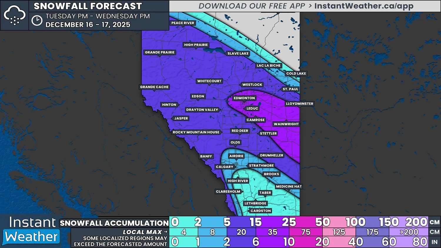
Blizzard Conditions Expected as High Impact Winter Storm Targets the Prairies Wednesday With Up to 30cm of Snow
/
NOTE: if you click or tap on this image you can zoom in
The next Clipper to cross the Prairies, the latest in the seemingly never-ending train of such systems, is setting up to be the most impactful of the season so far. This system will bring 15+cm of snow to all three provincial capitals, along with blizzard conditions to parts of Southern Saskatchewan and Manitoba Wednesday and into Thursday. There has been little change in the projected track of the Clipper since we shared our preliminary forecast Monday evening so many of the details remain the same and total snowfall accumulations have become clearer.
Alberta
Snow has fallen throughout the day Tuesday in the Rockies and this will continue into the evening and overnight. Late Tuesday evening, the snow will begin to expand southeastward from Northwestern Alberta as the low pressure center associated with the system starts to make its way into the province. The leading edge of the snow will cross Alberta through the early morning hours, reaching the Saskatchewan border shortly before sunrise.
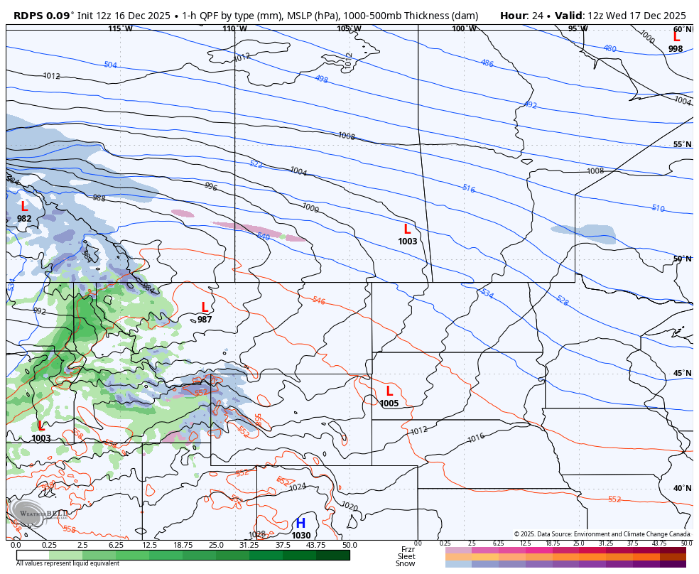
The rdps model showing precipitation type and intensity at 5Am MT on Wednesday, courtesy of WeatherBell.
The snow will be fairly light to moderate for most of the impacted areas of Alberta. A majority of Southern Alberta can expect less than 5cm since the precipitation will start off as a mixture of rain and freezing rain, possibly for several hours, due to the temperatures hovering around the freezing mark. However, there will be a switch over to snow as the temperatures drop, leading to the freezing of wet surfaces and minimal snow accumulation.
To the north, the lack of warm air and more consistent snowfall will result in greater accumulations. A large swath of Central Alberta and into Northern Alberta can expect 5-15cm of fresh snow, falling at rates of 1-2cm/hr during the late morning and early afternoon. In the Edmonton area and southeastward through Wainwright to the Saskatchewan border, heavier snow is expected to fall, possibly exceeding 3cm/hr, leading to rapid accumulation above 15cm.
In the early afternoon, the snow will begin to taper off from northwest to southeast across Alberta and it will gradually exit the province during the evening.
NOTE: if you click or tap on this image you can zoom in
The rdps model showing precipitation type and intensity at 12Pm CST on Wednesday, courtesy of WeatherBell.
Saskatchewan
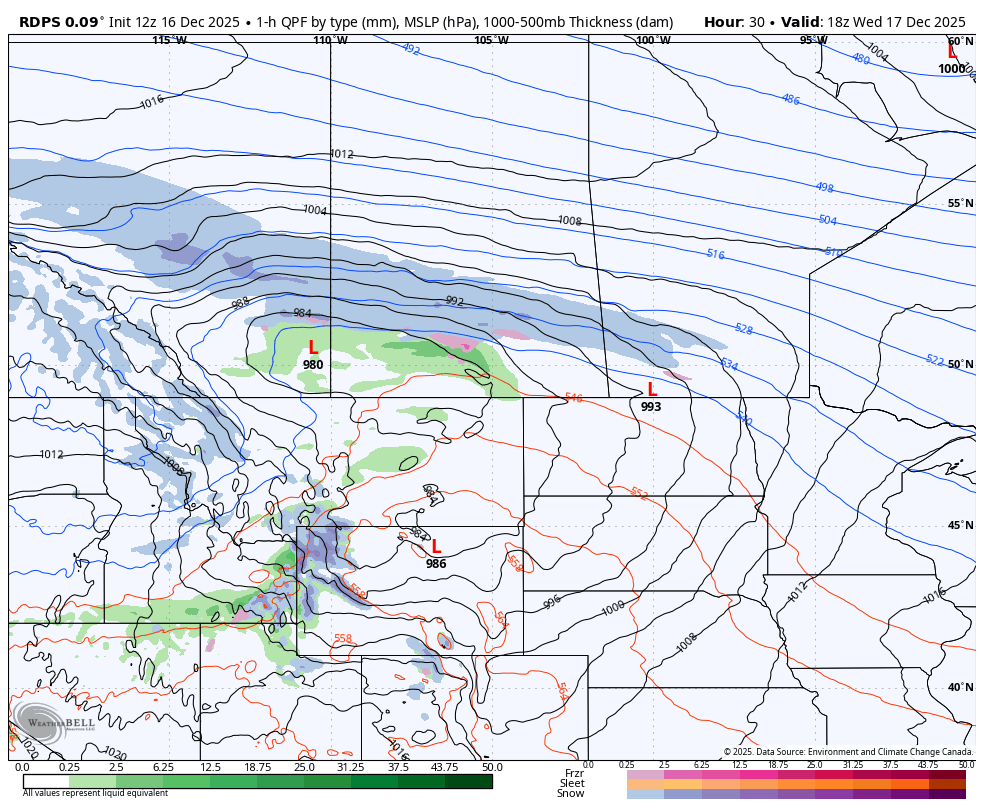
As the system makes its way through Saskatchewan, the situation becomes quite a bit messier. The leading edge of the precipitation will start to push through the province during the morning mostly as snow, but with rain, freezing rain, and ice pellets in the mix through the warmer air that will be present in Southern Saskatchewan. The freezing rain could last for several hours, resulting in a few millimetres of ice buildup on untreated surfaces. However, as the low tracks eastward during the afternoon, cold air will wrap around and result in a freezing of wet surfaces and a period of snow that follows.
Meanwhile, across Central Saskatchewan, as the snow moves through the province, it will intensify. Heavy snowfall rates up to 4cm/h during the afternoon and evening will result in the widespread quick accumulation of 15-30cm over an area that includes both Saskatoon and Regina.
The rdps model showing precipitation type and intensity at 7Pm CT on Wednesday, courtesy of WeatherBell.
Manitoba
The snow will finally start to cross into Manitoba in the late morning. There will be a much smaller pocket of warm air that will be isolated to the southwest corner of the province, so while there will be a chance for a brief period of freezing rain in Manitoba, the risk won’t be as prolonged or as widespread as in Saskatchewan.
The area of heavier snowfall will spread from Central Saskatchewan into Central Manitoba through the afternoon and evening, where it will also result in a widespread 15-30cm of fresh snow, including in Winnipeg.
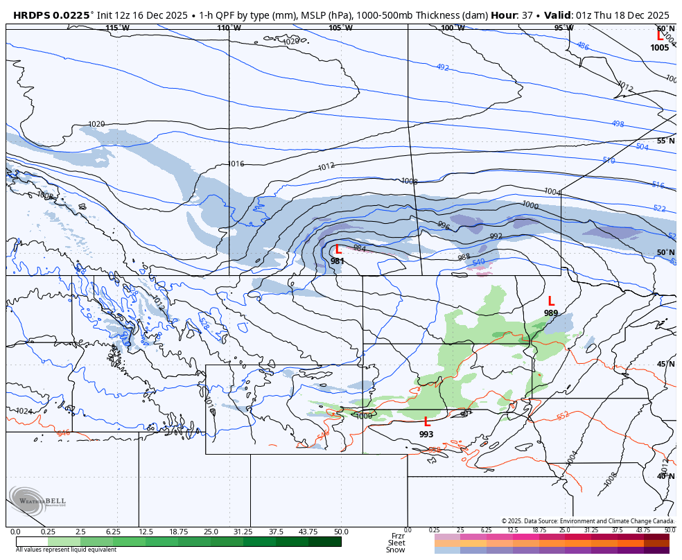
During the evening, the system will begin to shift and start to track more southward as it also loses some intensity. This will bring the main band of snow into Southeastern Saskatchewan and Southern Manitoba overnight and through Thursday morning.
In Saskatchewan, the snow will taper off starting shortly after midnight and exit the province by around sunrise. The snow will continue for a few extra hours in Manitoba, starting to dissipate during the early morning hours and eventually finishing in the southeast corner of the province in the afternoon.

NOTE: if you click or tap on this image you can zoom in
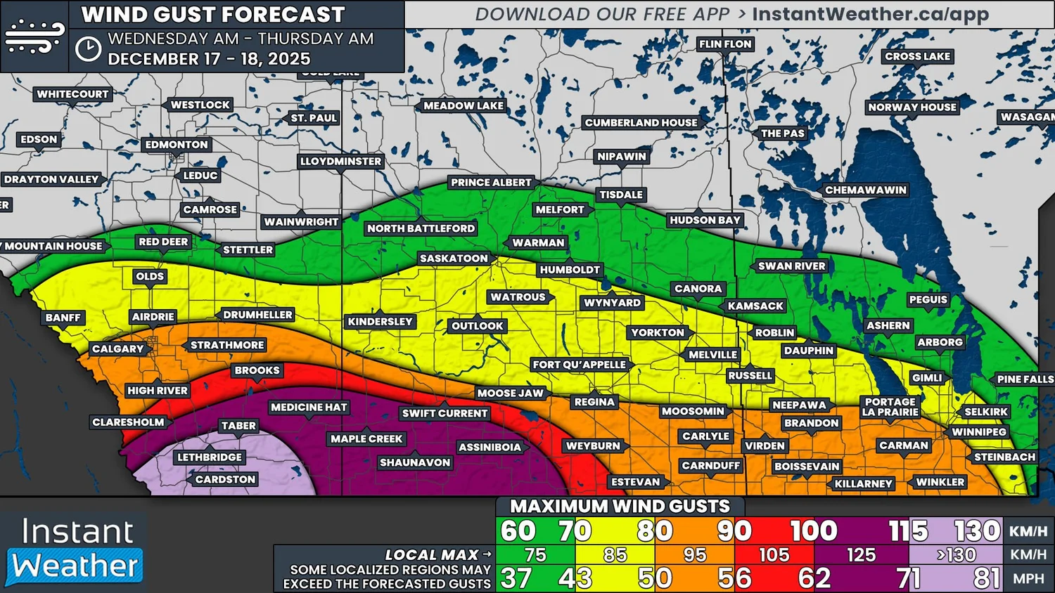
This only covers the snowfall aspect of this storm, but there is one major factor left to consider: the wind. Strong winds are expected to develop Wednesday morning and continue through the afternoon and evening before dying down overnight across the Prairies. We’re looking at widespread wind gusts over 60km/h and likely exceeding 100km/h, particularly in Southern Alberta and Saskatchewan. There is even the possibility of damaging wind gusts that approach 130km/h in parts of Southern Alberta!
While the most intense gusts will not coincide with the area where the heaviest snow is expected to fall, gusts above 60km/h will be more than enough for blizzard conditions to develop across Central Saskatchewan and into Central Manitoba starting in the afternoon and lasting into the overnight hours. This will likely result in large stretches of multiple highways being closed due to very poor visibility along with rapid accumulation of snow on the road surfaces.
For the rest of the region, where the wind gusts could be stronger, even a little bit of snowfall could severely impact visibility throughout the day.
Travelling in these conditions can extremely dangerous so please plan ahead, try to limit any travel, and stay safe!
NOTE: if you click or tap on this image you can zoom in


