‘Strong’ Geomagnetic Storm Takes Aim at Earth; Northern Lights May Dazzle the Skies Across Canada on Thursday & Friday

NOTE: YOU CAN CLICK ON THE MAP TO OPEN A ZOOMABLE IMAGE

One of the most powerful solar flares in recent years erupted from the sun on Tuesday evening, classified as an X7.1 flare. Initially, it was unclear whether this flare had produced a coronal mass ejection (CME), which is a large expulsion of plasma and magnetic field from the sun’s corona.


However, data that came in later confirmed that a CME was indeed produced and, more importantly, appears to be Earth-directed. This means that the CME is expected to impact our planet, setting off the possibility of a ‘strong’ geomagnetic storm and potentially bringing the northern lights much farther south than usual across Canada to close out the week.

The exact timing of the CME's arrival, however, remains somewhat uncertain. Forecast models suggest it could arrive anywhere between late Thursday and early Saturday. The CME might even come in multiple waves, according to the latest data.

If this happens, we could be in for two consecutive nights of auroras lighting up the skies—if the conditions align perfectly! While the Northern Lights are never guaranteed, the next couple of nights offer a decent chance to catch a breathtaking display, depending on where you are located.


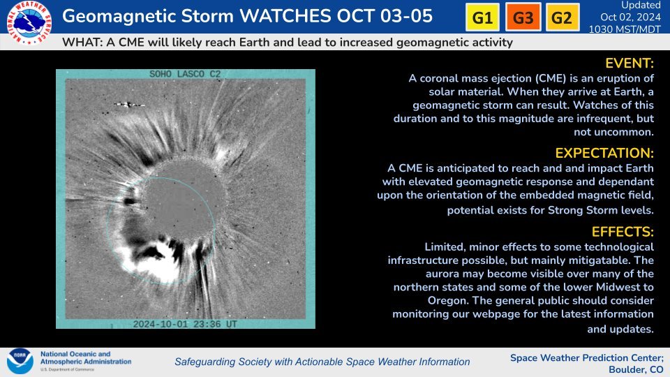
The Space Weather Prediction Center (SWPC) has issued a Geomagnetic Storm Watch, with the CME expected to reach Earth between Thursday and Saturday. Based on the latest observations, this CME could trigger G1 (minor) to G3 (strong) geomagnetic storm conditions.

The SWPC’s latest forecast predicts that a 'strong' (G3) geomagnetic storm may unfold late Thursday evening into the early overnight hours, followed by a potentially more prolonged geomagnetic storm ranging from ‘moderate’ (G2) to ‘strong’ (G3) on Friday night into Saturday morning.


A G2 to G3 storm is strong enough to make the northern lights visible across much of Canada, especially if conditions are just right. In the past, storms of this magnitude have allowed the auroras to be seen as far south as Southern Ontario, and in some cases, even into the northern United States. In fact, the SWPC notes the possibility of the auroras being visible as far south as parts of the lower Midwest and Oregon in the U.S.

That said, space weather forecasting comes with some inherent uncertainty. The exact timing of a CME’s arrival can vary, and its intensity is often unknown until a few hours before it strikes Earth. There is usually a 12- to 24-hour window for the CME’s arrival, which means that although the current forecast favours North American viewing on Thursday and Friday nights, the event could just as easily occur during daylight hours, rendering it invisible to viewers in North America and giving those in Europe a better chance at catching the show instead.


NOTE: YOU CAN CLICK ON THE MAP TO OPEN A ZOOMABLE IMAGE

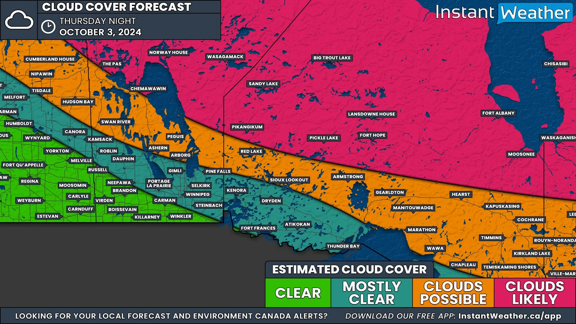
Aside from timing, cloud cover will also be a crucial factor in determining whether you'll have a good view of the northern lights. As of now, fairly clear skies are expected across much of southern Canada on Thursday night. Specifically, areas of Atlantic Canada, Southern Quebec, and Southern Ontario are forecasted to have little to no cloud cover during the overnight hours, which is ideal for aurora viewing.

NOTE: YOU CAN CLICK ON THE MAP TO OPEN A ZOOMABLE IMAGE

Further north, however, there could be widespread cloud cover that might obstruct the view around James Bay in Northern Ontario and Quebec. Similarly, Northwestern Ontario could see some cloudiness, with the exception of a pocket near the International border around Thunder Bay.

In Southern Manitoba, skies look clear south of the Interlake region, though clouds will likely impact Northern Manitoba and Saskatchewan.


NOTE: YOU CAN CLICK ON THE MAP TO OPEN A ZOOMABLE IMAGE

For Western Canada, Southern Saskatchewan and Southeastern Alberta are expected to have the clearest conditions. Meanwhile, much of British Columbia, along with central and northern Alberta, could see cloud cover that may limit visibility.

Check out our free app, Instant Weather for a more in-depth cloud coverage forecast specific to your exact location.

If you’re planning to watch for the auroras, another factor working in your favour this time around is the moon phase. Unlike last month’s aurora event, the moon is currently near 0% full, as we’ve just had a new moon on Tuesday night. This means that there won’t be any moonlight competing with the northern lights, making it easier to spot even faint auroras.


NOTE: YOU CAN CLICK ON THE MAP TO OPEN A ZOOMABLE IMAGE

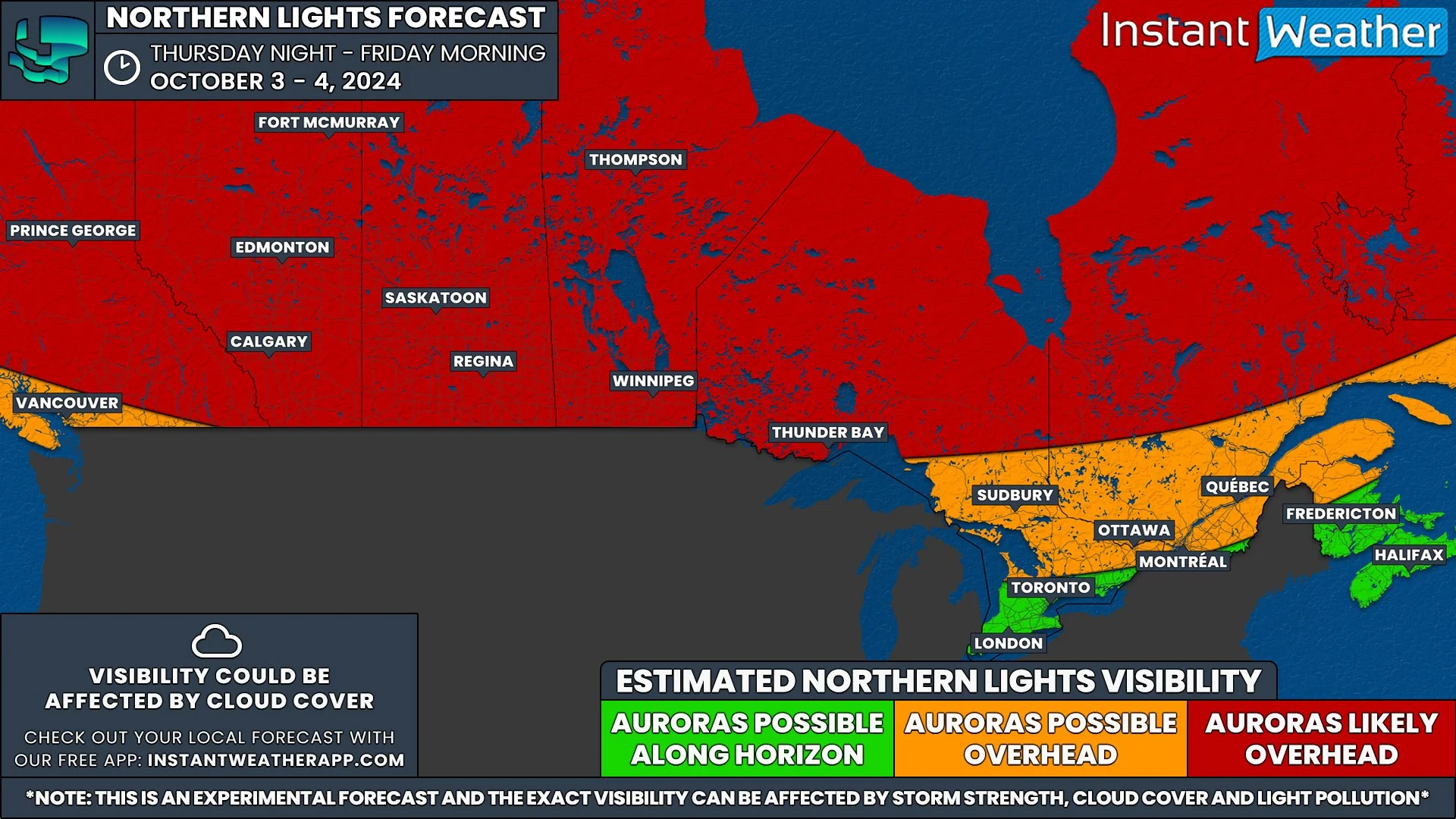
When it comes to where the northern lights might be visible, it all depends on the strength of the geomagnetic storm and how it interacts with Earth’s magnetic field. Historically, during a 'strong' (G3) storm, auroras are most visible across northern Canada, including Northern Quebec, Far Northern Ontario, the Prairies, and parts of British Columbia. In these regions, the northern lights could be visible overhead and bright enough to see with the naked eye.

In southern regions, including Northeastern Ontario (Sault Ste. Marie, Sudbury, and North Bay), as well as parts of Quebec, there’s a chance of seeing the auroras overhead or just above the horizon.

This could extend into northern parts of Southern Ontario, including Muskoka, Algonquin Park, and the Ottawa Valley. However, depending on the storm's strength, auroras may only be visible along the northern horizon, and you might need a camera to capture them, as they may not be strong enough for the naked eye.


For the rest of Southern Ontario and into Atlantic Canada, if the auroras appear, they will likely be on the northern horizon. Here, too, you may need a camera or smartphone to capture the lights, as they may be too faint to see without assistance.

Remember, light pollution can greatly impact your ability to see the northern lights, especially in urban areas. For the best viewing experience, it’s essential to get away from city lights. A resource like DarkSiteFinder can help you locate areas with low light pollution for optimal aurora viewing.


Northern Lights Timing

Many are accustomed to the precise scheduling of weather events, from thunderstorms and winter weather to solar eclipses, where timing is crucial. It’s understandable, then, that there’s a desire for a similar pinpoint timing for the best viewing of the aurora. However, the reality of predicting the best time to view the northern lights is not so straightforward.

Here’s the deal: Unlike weather events driven by terrestrial conditions, the aurora is influenced by solar activity, which is far less predictable. We can estimate that the northern lights are best viewed from just after sunset to just before sunrise, provided the skies are dark and clear. Beyond that, precise timing for peak aurora activity is challenging to forecast with current technology.


Space weather forecasting doesn't yet allow us to predict exactly when solar energy will impact Earth. We know it's coming, but how and when it interacts with our planet's magnetic field can vary. Often, we only have a few hours' notice before the solar energy is detected by satellites.

Furthermore, the intensity of the northern lights can fluctuate significantly over short periods. You might have noticed this variance if you've observed the lights before—periods of dim activity suddenly bursting into vibrant colors. This is due to the variable concentration of solar particles interacting with our atmosphere.

While we can inform you a few hours ahead when conditions are likely to be good, predicting the exact peak of aurora activity is akin to forecasting the peak of a meteor shower; we know the best night but not the best hour.


Eyes to the Sky! Northern Lights Could Make an Appearance Across Canada on Monday

NOTE: YOU CAN CLICK ON THE MAP TO OPEN A ZOOMABLE IMAGE

A powerful solar flare, reaching an impressive X4.5 rating, erupted on Saturday, sending an Earth-directed coronal mass ejection (CME) into space. This CME is expected to impact our planet, sparking geomagnetic storm conditions that could bring the northern lights much farther south than usual across Canada on Monday.

As with most space weather events, there is some uncertainty regarding the exact timing of the CME's arrival. According to the latest data, the strongest storm conditions are anticipated during the mid to late morning hours on Monday, gradually weakening throughout the day. This suggests the best viewing opportunity for the auroras may occur in the pre-dawn hours, particularly in Western Canada.


However, this isn’t set in stone. Space weather forecasting can be tricky, and the CME might arrive later than expected, which would actually be the ideal outcome for North American skywatchers. A delayed arrival could mean a spectacular display of the northern lights over large portions of the country on Monday night.

The Space Weather Prediction Center (SWPC) is forecasting a "strong" geomagnetic storm (G3 on a scale of 5) to develop sometime on Monday. A G3 storm is potent enough to make the northern lights visible across much of Canada, provided the conditions align just right.

Historically, storms of this strength have allowed auroras to be seen as far south as Southern Ontario, and sometimes even into northern parts of the United States. In fact, the SWPC mentions the possibility of auroras being visible as far south as Pennsylvania and Iowa.


Based on the SWPC’s latest forecast, the geomagnetic storm is expected to peak between 5 AM and 11 AM EDT (2 AM to 8 AM PDT). A moderate (G2) storm is projected to continue through the day, potentially lasting until 11 PM EDT (8 PM PDT).

If this timing holds, the best chances to witness the northern lights would be in Western Canada during the early morning hours on Monday, when the storm is at its peak. Unfortunately, for those in Ontario and Quebec, the storm may hit after sunrise, reducing the likelihood of a good aurora display.

That said, if the CME arrives later in the day, it could extend the storm into Monday night, offering a better chance for Eastern Canada to catch the auroras, assuming clear skies.


IMAGE FROM WeatherBell

Speaking of skies, Monday night’s cloud forecast looks promising for much of Canada. The latest model shows most areas should have a good view, with only Southeastern Manitoba, Northwestern Ontario, and Northern Quebec facing potential cloud cover that might obscure the show.

Southern Saskatchewan and Northern Alberta may see patchy clouds but could have breaks offering decent aurora visibility. For Southern Ontario, Quebec, and most of Western Canada, skies are expected to remain clear.

Check out our free app, Instant Weather for a more in-depth cloud coverage forecast specific to your exact location.

Another potential issue will be the full moon leading to the possibility of the northern lights appearing more dim and harder to spot. However, if the storm is as strong as forecasted, there still should be some chance to capture the show despite the bright moon.


NOTE: YOU CAN CLICK ON THE MAP TO OPEN A ZOOMABLE IMAGE

Northern regions of Canada, especially Northern Quebec, the Prairies and British Columbia, are almost guaranteed to see the northern lights, except for areas in Southwestern BC near Vancouver where visibility is less certain.

Zooming into more southern regions, the likelihood of seeing auroras becomes more variable. Northeastern Ontario, including Sault Ste. Marie, Sudbury, and North Bay, along with Western and Northern Quebec, have a strong chance of aurora sightings.

In Central Ontario, places like Muskoka, Algonquin Park, Bancroft, and the Ottawa Valley also have a moderate chance, as do areas around Montreal. However, the timing of the storm’s arrival remains a key factor—if it’s delayed and peaks closer to sunset, a G3 storm would likely provide an opportunity for these regions to witness the lights.

In Southwestern Ontario, the Golden Horseshoe, and southern Quebec near the American border, the probability becomes more uncertain. There’s a low to slight chance of auroras being visible here, depending on whether the storm overperforms or peaks later in the night.


It’s important to keep in mind that light pollution can drastically affect your ability to see the northern lights. Urban areas, in particular, can drown out the skies, so you’ll need to find a dark spot away from city lights for the best chance to see the show. A resource like DarkSiteFinder can help you locate areas with low light pollution for optimal aurora viewing.


Northern Lights Timing

Many are accustomed to the precise scheduling of weather events, from thunderstorms and winter weather to solar eclipses, where timing is crucial. It’s understandable, then, that there’s a desire for a similar pinpoint timing for the best viewing of the aurora. However, the reality of predicting the best time to view the northern lights is not so straightforward.

Here’s the deal: Unlike weather events driven by terrestrial conditions, the aurora is influenced by solar activity, which is far less predictable. We can estimate that the northern lights are best viewed from just after sunset to just before sunrise, provided the skies are dark and clear. Beyond that, precise timing for peak aurora activity is challenging to forecast with current technology.


Space weather forecasting doesn't yet allow us to predict exactly when solar energy will impact Earth. We know it's coming, but how and when it interacts with our planet's magnetic field can vary. Often, we only have a few hours' notice before the solar energy is detected by satellites.

Furthermore, the intensity of the northern lights can fluctuate significantly over short periods. You might have noticed this variance if you've observed the lights before—periods of dim activity suddenly bursting into vibrant colors. This is due to the variable concentration of solar particles interacting with our atmosphere.

While we can inform you a few hours ahead when conditions are likely to be good, predicting the exact peak of aurora activity is akin to forecasting the peak of a meteor shower; we know the best night but not the best hour.

UPDATE: Slight Risk for Severe Thunderstorms for Friday Now Extends into Calgary

NOTE: YOU CAN CLICK ON THE MAP TO OPEN A ZOOMABLE IMAGE

In an update to the forecast that was posted yesterday evening, we have extended the boundaries of the Slight Risk region to include Calgary and the entire Highway 2 corridor south of the city. The combination of damaging wind gusts, large hail, and the possibility of an isolated tornado from today’s has resulted in the Slight Risk for this area, along with Lethbridge, Medicine Hat, and Drumheller.


Thunderstorms have already begun to develop in Montana, moving northward towards the border. They will start to cross into Alberta later this afternoon and early evening, spreading across Southern Alberta throughout the rest of the evening and overnight. It’s possible that the storms could become organized into a line that will push northeastward starting later in the evening which will impact a more widespread area than just isolated storms.


The main threat from these storms will be the hail, with up to toonie to timbit-size likely, as well as damaging wind gusts that could exceed 100km/h and even approach 130km/h. At this time, there does not appear to be too much of a flooding risk, with these storms expected to bring less than 50mm of rain over the span of a few hours. An isolated tornado can also not be completely ruled out.

Slight Risk for Severe Storms in Southern Alberta to Finish the Week; Forecast Could be Upgraded

NOTE: YOU CAN CLICK ON THE MAP TO OPEN A ZOOMABLE IMAGE

Friday will be another hot day across Southern Alberta and along with that heat comes severe thunderstorms. A combination of damaging wind gusts, large hail, and the possibility of an isolated tornado means that there will be a Slight Risk in an area that includes Lethbridge, Medicine Hat and north towards Drumheller.


The storms will cross into Alberta from Montana in the south starting in the late afternoon and early evening, spreading across the region throughout the evening and overnight hours. It’s possible that the storms could become organized into a line that will push northeastward starting later in the evening that will impact a more widespread area than just isolated storms.


The main threat from these storms will be the hail, with up to toonie-size likely, as well as damaging wind gusts that could exceed 100km/h. At this time, there does not appear to be too much of a flooding risk, with these storms expected to bring less than 50mm of rain over the span of a few hours. An isolated tornado can also not be completely ruled out. The risk level could change with more data from short-range models so stay tuned for any updates to this forecast.