Isolated Severe Thunderstorm Potential This Afternoon & Evening (Mon, June 6, 2022)

NOTE: You can click on the map to open a zoomable image which will be easier to read.

Isolated severe thunderstorms are possible this afternoon and evening across parts of southwestern Ontario and there is a hint of potential in the Niagara regions and the west side of the GTHA. Most storms will remain sub-severe (below severe thresholds). However, there is a chance that they could briefly produce damaging wind gusts, hail, isolated flooding and frequent lightning. Overall, the tornado potential is marginal (low) but there is a hint of tornado potential with storms that may move northeast off of Lake Huron, perhaps near the Goderich or Kincardine areas and also some risk in deep southwestern Ontario. We’ve highlighted this with the dotted region and the letter T.

Monday and Tuesday will bring quite a bit of rainfall across the region and there is a marginal (low) risk for isolated flooding in any areas that receive numerous storms.

Environment Canada has also mentioned that an isolated tornado cannot be ruled out in their updated forecast map, which they often post to Twitter:

NOTE: You can click on the map to open a zoomable image which will be easier to read.

As always, if we see any rotation on radar we will do our best to notify all those who have our free app Instant Weather and who subscribe to our premium Text Message Alerts as well as through Facebook, Twitter, etc.

More details ASAP.

Isolated Severe Thunderstorm Risk: Overnight, Morning, Afternoon, and Evening (Wed, Jun 1, 2022)

NOTE: You can click on the map to open a zoomable image which will be easier to read.

Isolated severe thunderstorms are possible this Wednesday. By “Isolated” we mean that many areas could end up seeing no storms at all. However, even though the storms should remain isolated, many in our community will end up seeing storm activity as there could be quite a few of them, several rounds, and likely in populated areas.

Overnight & Early morning (12am - 8am): Overnight and early morning storms should begin moving east from Lake Huron near Kincardine and tracking towards Georgian Bay, Barrie, etc. We’ll also see storms moving east from Georgian Bay, starting around midnight or so and tracking into Muskoka and parts of eastern Ontario. These overnight and early morning storms have a marginal (low) risk for severe weather but they could bring with them isolated flooding, strong (potentially damaging) wind gusts, hail, and lightning. Tornado activity with these overnight and early morning storms is unlikely but we’ll be watching them, nonetheless as they may end up showing rotation on radar.

Morning: (8am - 11am): The morning storms will have a stronger environment to work with as they track through parts of southwestern and central Ontario, perhaps towards the GTA regions and parts of eastern Ontario. Damaging wind gusts, hail, flooding and lightning are the main risks. Tornado activity with these morning storms is also unlikely. Although, slightly less unlikely than the overnight and early morning storms.

Afternoon & evening: (12pm - 8pm): The afternoon storms are the main concern for tomorrow and we should see these develop around the noon hour or slightly thereafter. Multiple isolated supercells (rotating storms) are possible and at this point, we’re seeing a highlighted risk in southwestern, central, golden horseshoe (GTHA), and parts of eastern Ontario. Large hail, damaging wind gusts, frequent lightning, isolated flooding, and isolated tornadoes will be possible. The dotted “tornado risk” area on the map is specifically showing where the afternoon and evening storms should develop but we’d like to clarify that an isolated tornado outside of this highlight area isn’t entirely out of the question with the morning storms even though their overall tornado potential seems less likely than the afternoon storms.

If we see any rotation on radar, we will do our best to notify all those who have our free app Instant Weather and who subscribe to our premium Text Message Alerts as well as through Facebook, Twitter, etc. Having said that, Facebook notifications are usually very slow so please do not depend on them being timely.

And once again, a huge thank you to all those who share our updates and support our team and community! It makes all of this possible and helps us continue to achieve our goal of raising awareness about tornadoes and severe weather. Thank you!

More details ASAP.

NORTHWESTERN ONTARIO: Significant Severe Thunderstorm Risk This Evening & Overnight (Mon, May 30, 2022)

NOTE: You can click on the map to open a zoomable image which will be easier to read.

We’re dealing with an ongoing significant severe weather outbreak in the US that will eventually impact parts of northwestern Ontario this evening and into the overnight hours. Isolated tornadoes, damaging wind gusts, large hail, flooding and frequent lightning are all possible. Tornadoes will be especially possible in the red area of the map, highlighted with the number 4 and the dotted region, close to the international border. Fort Frances and surrounding areas may have the strongest potential for significant severe weather and dangerous tornado activity. Environment Canada has already issued a Tornado Watch for regions like Fort Frances and areas close to the international border.

There is also a marginal risk for severe weather in parts of northeastern Ontario, close to the Quebec border but it’s a bit uncertain at this point in time.

If we see any rotation on radar, we will do our best to notify all those who have our free app Instant Weather and who subscribe to our premium Text Message Alerts as well as through Facebook, Twitter, etc.

Just want to say a huge thank you to all those who share our updates and support our team and community! It really makes a huge difference.

More details ASAP.

MANITOBA: Isolated Severe Thunderstorm Risk This Afternoon and Evening (Sunday, May 29, 2022)

NOTE: You can click on the map to open a zoomable image which will be easier to read.

We’re carefully watching for the risk of isolated severe thunderstorms this afternoon and evening across parts of southern Manitoba. There is some uncertainty as to where these storms will first develop and how late they may arrive. However, the latest model data is suggesting the strongest isolated storms will begin in the west part of the risk region this afternoon and track east throughout the evening. The main risks will be damaging wind gusts, large hail, isolated flooding and frequent lightning. There is also the potential for tornado activity, especially close to the international border. However, the tornado risk may have the potential to extend further north as highlighted by the dotted orange areas, depending on where the strongest storms develop and how earlier they arrive. The earlier they arrive, the better chance they have of being severe and potentially producing isolated tornadoes, etc.

Environment Canada has also issued a forecast map for these risks:

NOTE: You can click on the map to open a zoomable image which will be easier to read.

In their forecast, Environment Canada writes: “… potential for severe thunderstorm development. Large hail, heavy rain, and the slight chance for a tornado are all possible. However, a strong mid level capping inversion may hinder thunderstorm development until much later in the evening, once the cap erodes. As such, confidence is low for any organized storm development, but any storms that do pop up will likely be severe in nature.”


As always, if we see any rotation on radar, we will do our best to notify all those who have our free app Instant Weather and who subscribe to our premium Text Message Alerts as well as through Facebook, Twitter, etc.

If you’re on Facebook, please join our sister group Manitoba Storm Reports to share your reports with not only us but members of the community.

Long story slightly longer, thank you to all those who share our updates and support our team and community! It really makes a huge difference!

More details ASAP.
Isolated Severe Thunderstorm Possible This Afternoon & This Evening (Thursday, May 26, 2022)

NOTE: You can click on the map to open a zoomable image which will be easier to read.

Isolated severe thunderstorms are possible this afternoon and evening across parts of southwestern, central, and perhaps eastern Ontario. Most storms will remain sub-severe (below severe thresholds). However, there is a chance that they could briefly produce damaging wind gusts, hail, isolated flooding and frequent lightning. Tornado activity seems unlikely but there is a bit of potential for rotation with these storms so perhaps we could see a funnel cloud report or a brief landspout tornado.

If we see any rotation on radar, we will do our best to notify all those who have our free app Instant Weather and who subscribe to our premium Text Message Alerts as well as through Facebook, Twitter, etc.

Just want to say a huge thank you to all those who share our updates and support our team and community! It really makes a huge difference. And our most heartfelt thoughts and condolences remain with those who were affected by Saturday’s devastating derecho storm and embedded tornadoes.

More details ASAP.

Severe Thunderstorm Risk for Saturday, May 21st, 2022

NOTE: You can click on the map to open a zoomable image which might be easier to read due to the small labels. If you prefer our old city label format, we have included that further down this article.

Another severe thunderstorm risk for this morning, afternoon and perhaps this evening in parts of eastern Ontario, especially in the Cornwall areas and close to the Quebec border.

Damaging wind gusts, large hail, isolated flooding and frequent lightning are the main risks. We’ve also highlighted an area with the blue dashed outline + dotted region where there is a marginal (low) chance of tornado activity. The chance gets stronger the closer to Quebec you are, especially in far eastern Ontario.

If we see any rotation on radar, we will do our best to notify all those who have our free app Instant Weather and who subscribe to our premium Text Message Alerts as well as through Facebook, Twitter, etc.

Just want to say a huge thank you to all those who share our updates and support our team and community! It really makes a huge difference. Thank you and be safe if you’re in the path of today’s storms!

More details ASAP.

Evening and Overnight Risk for Severe Thunderstorms (Friday, May 20th, 2022)

NOTE: You can click on the map to open a zoomable image which might be easier to read due to the small labels. If you prefer our old city label format, we have included that further down this article.

As previously mentioned, this forecast has been quite challenging. When there is an environment this strong (moisture + heat + wind shear) but a general lack of expected storms, it’s always a big question mark regarding if storms could potentially pop-up earlier than expected. Nevertheless, we’ve been over so many models and observations and we feel that our map, with a slight modification from yesterday’s preliminary forecast, which now extends the severe risk further into northeastern Ontario, should cover all the possibilities.

Several models are continuing to suggest the storms will arrive late and not be as significant. However, a few others suggest the storms roll into the Bruce Peninsula and the northern side of Lake Huron into areas around Sauble Beach around 7-8pm. If the storms arrive early, they’re going to likely be quite severe and could cause significant damaging wind gusts, large hail, isolated flooding, intense lightning, and perhaps even a tornado or two are possible. If the storms arrive around later into the evening, they won’t have as much of an opportunity to take advantage of the significant supercell environment that is already strengthening across much of southern, central and northeastern Ontario. However, severe storms are still possible overnight as they track into Muskoka and northeastern Ontario.

So far, areas like the Bruce Peninsula, the north side of Lake Huron, through the Georgian Bay regions and into parts of Muskoka and northeastern Ontario seem to be where the strongest nocturnal storms should arrive. 

The later they arrive, the less chance they have of producing significant severe weather.

We continue to hope that they arrive as late as possible and the outcome is simply a noisy/windy/rainy evening for some. *Fingers continued to be crossed* 🤞

There will also be the chance for thunderstorms on Saturday morning, potentially around the Hamilton area and there is some potential they could be severe.

More details ASAP!

Winter’s Grip on Ontario Continues With Freezing Rain Risk in the South and Heavy Snow in the North Between Wednesday and Thursday

It might be officially spring, but it appears that Mother Nature missed the memo as we are expecting a system to bring a messy mix of wintery precipitation across Ontario over the next few days. The effects of this storm will begin to be felt in Deep Southwestern Ontario during the predawn hours on Wednesday. This includes Windsor, Chatham, Sarnia and London where temperatures will be hovering near the freezing mark throughout the morning. As a result, there is the risk of freezing rain for several hours as the precipitation works its way throughout the region. Do note that this will be very temperature dependent and some areas may see just all rain if it’s slightly warmer than expected.

Later in the morning on Wednesday, we will see the precipitation push to the northeast into the rest of Southwestern Ontario and the GTA with the risk of freezing drizzle or rain. Again, this will be very dependent on the temperature so the worst conditions will be found in the higher elevations (K/W, Guelph and Orangeville etc.) with less of an impact closer to the lakeshore. This could lead to some icy driving conditions during the morning commute on Wednesday so be sure to leave plenty of time to get to your destination.

In terms of ice accretion, the heavier precipitation will be found throughout Deep Southwestern Ontario southeast of Lake Huron so they could pick up around 2-4mm of ice accretion. The rest of Southwestern Ontario and the GTA is expected to experience more scattered freezing rain so it won’t be as sustained with less than 2mm of total icing. We will see the freezing rain risk linger into the afternoon as temperatures still remain slightly below the freezing mark, but there will be a break in the precipitation which should help limit the impact. Temptarues will slowly rise above the freezing mark towards the evening and overnight into Thursday.

Another area of concern we’re closely watching is east of Georgian Bay and up into Northeastern Ontario. This area has the risk of freezing rain starting late Wednesday afternoon continuing into the overnight and Thursday morning. Those in Central and Eastern Ontario can expect between 2-6mm of ice accretion by Thursday morning as temperatures climb above the freezing mark overnight. The more prolonged freezing rain will be found north of Georgian Bay including Elliot Lake, Sudbury and North Bay. Several hours of heavy freezing rain with up to 6-10mm of ice accretion is possible. This amount of icing will likely lead to some power outages and impact to travel so consider avoiding any non-essential travel through the region.

Conditions on Thursday will do a complete 180 across Southern Ontario as warmer air push temperatures into the double digits during the morning and afternoon. This will be accompanied by scattered showers and rain with even the risk of an isolated non-severe thunderstorm. Strong to damaging wind gusts will also be an issue early Thursday morning and into the afternoon. Current indications suggest that regions east of Lake Huron into the GTA could see wind gusts ranging between 70-90km/h with locally stronger gusts up to 100km/h along the shorelines. More details on this will be covered in a separate wind forecast to be issued on Wednesday as we get closer to Thursday.

For Northern Ontario, the story will be more of a traditional snowstorm for a wide swath of the area. Along with the aforementioned prolonged freezing rain just north of Georgian Bay. Snow has already begun to move into Northwestern Ontario this evening around the Manitoba border. It is expected to spread eastward throughout the overnight and into Wednesday. The heaviest snow will be found from Thunder Bay through Geraldton and Moosonee starting Wednesday afternoon and evening. Conditions here will be quite poor with blowing snow and rapid accumulation - road and highway closures are likely later in the day on Wednesday. There will be a short break for the snow early Thursday morning, but another round of heavy snow is expected to move through Northeastern Ontario (it should remain east of Thunder Bay closer to Wawa and Timmins) during the day on Thursday.

Total snowfall accumulation in the hardest-hit regions will likely exceed 20cm and could even approach 30cm by the end of Thursday. This includes Geraldton, Kapuskasing, Wawa and Cochrane while Thunder Bay will likely top out at around 15cm. Lower snowfall accumulation of around 5-15cm is expected through Chapleau and Timmins where sleet and freezing rain mixing in will reduce accumulation. Sault Ste. Marie, Elliot Lake, Sudbury and Temiskaming Shores will experience mainly freezing rain with significant icing of 6mm+ possible. The freezing rain will transition over to regular rain Thursday morning as the temperature climbs above the freezing mark.

Temporary Return to Winter As Snow Squalls Could Dump Up to 30cm of Snow Through Parts of Southern Ontario’s Snowbelt by Monday

We might have been treated to quite a mild start to spring across Southern Ontario so far, but that is about to change over the next few days. Cold arctic air will flood into the region late Saturday night into Sunday morning bringing temperatures that feel more like early December than the beginning of spring. It will only get colder as we head into Monday with wind chills approaching the -20s in some parts of Southern Ontario as you start the day on Monday!

This colder area will also help turn back on the lake effect snow machine over the next few days with snow squalls potentially bringing significant snowfall accumulation to parts of the Snowbelt. Poor driving conditions with blowing snow and rapid snowfall accumulation will be a common occurrence starting early Sunday morning lasting throughout the day and into early Monday. Localized road and highway closures are likely in the affected region, so it’s a good idea to avoid travelling east of Lake Huron and south of Georgian Bay until later on Monday.

Light scattered flurries are currently ongoing in parts of Southwestern and Central Ontario as of Saturday afternoon as temperatures slowly make their way below the freezing mark. By midnight, we should see some more persistent and heavy bands of snow develop around the eastern Lake Huron shoreline and south of Georgian Bay. It doesn’t appear that this area of lake effect snow will be particularly organized until we get into mid to late morning on Sunday as a more intense squall will set up. The main squall will be located off Lake Huron somewhere between Kincardine and Goderich along with a secondary squall off Georgian Bay coming inland over Meaford and extending into the Collingwood/Wasaga Beach area.

There is some disagreement among the models on the exact wind direction which makes it difficult to narrow down the placement of the squalls. However, it does appear that the squall off Lake Huron will meander around a bit throughout the day on Sunday which should help limit the overall accumulation for each location. It looks like it will start out near Goderich, Grand Bend and Exeter early Sunday morning before shifting northward towards Kincardine and Hanover by the afternoon. It should slowly make its way back to the south and could lock in for a few hours around Exeter and Stratford into early Monday morning.

For Georgian Bay, current indications suggest that the lake effect snow will be mostly contained to the shoreline with a focus on the Collingwood, Meaford and Wasaga Beach region. By Sunday evening, the snow squall may strengthen to an extent and reach further inland towards Barrie, Innisfil and across Hwy 400 into York Region. This will bring the chance for a quick 5-10cm of snow in this area with locally even higher amounts if it locks in for several hours. Parts of the GTA and the City of Toronto may even see some heavier snow around midnight as the edge of the squall shifts into the city, but accumulation isn’t expected to be significant.

The snow squall activity will taper off by late Monday morning or early afternoon. Depending on the strength of the squalls in the morning, it could prompt some school bus cancellations around Lake Huron and Georgian Bay on Monday. In terms of overall snowfall accumulation including tonight, Sunday and early Monday, we expect that some areas east of Lake Huron could pick up to 30cm of snow. This includes Goderich, Kincardine, Wingham, Listowel and Hanover. However, not everyone will see anywhere near 30cm as snow squalls are very localized and the exact totals for each location will vary significantly from a few centimetres to near 30cm. It all depends on the wind direction and intensity of the squall, but the potential is there.

Surrounding regions including Grand Bend and Stratford along with the Southern Georgian Bay shoreline can expect up to 20cm by Monday from the snow squall activity. Those in London, K/W, Owen Sound and Barrie could see the occasional brief snow squall move through the area leading to accumulation up to 10cm. Do note that there is some higher uncertainty around the Barrie area and southward along Hwy 400 where one model does show that the squall could become quite intense overnight Sunday. It’s not out of the question that localized accumulation here approaches 15-20cm, but there isn’t enough confidence to include it on the map. In addition to this, the Niagara region mainly through Fort Erie could see a brief squall early Sunday morning off Lake Erie before it moves stateside leading to up to 10cm of snow.

Freezing Rain Risk and Damaging Wind Gusts Possible Across Southern Ontario on Wednesday

A moisture-laden Texas low is expected to bring a messy mix of precipitation to Southern Ontario throughout the day on Wednesday. The main concern will be the risk of prolonged freezing rain in the higher elevations northwest of the GTA along with parts of Central Ontario during the morning on Wednesday. Combined with strong wind gusts reaching 80-100km/h, particularly through Southwestern Ontario will likely result in some localized power outages in the affected regions. For the rest of Southern Ontario, we are looking at heavy rainfall with generally between 15-30mm of rain accumulation although some parts of Deep Southwestern Ontario including Windsor could approach 40-50mm thanks to some thunderstorm activity later in the day on Wednesday. This may result in some localized flooding so be on alert for that if you live in a flood-prone area.

Precipitation associated with this system will begin to reach our region just after midnight starting as rain for Deep Southwestern Ontario. However, by the mid-morning hour, the precipitation will clash with below-freezing temperatures hovering around -2 to 0°C around the Orangeville and K/W area. This will allow for the development of a band of freezing rain that is expected to last for several hours. Those in the surrounding regions including London, Woodstock, Hamilton and the GTA away from the lakeshore could see some brief freezing rain or ice pellets before temperatures quickly rise above the freezing mark. Another stubborn pocket of cold air over Central Ontario including Algonquin Park and Bancroft will create the environment for some freezing rain here late Wednesday more and into the afternoon.

There is some disagreement among the models on exactly how fast the temperatures will warm up later in the day. One model, in particular, is quite aggressive showing below-freezing temperatures over the Dundalk Highlands lingering into the evening. As a result, that would lead to a fairly heavy icing event of up to 8-12mm of ice accretion possible for the K/W, Orangeville and Guelph region. Although other models show a faster warm-up with the freezing rain risk ending by the mid-afternoon which would limit accretion to 2-4mm max. We’re leaning more towards the 2-4mm outcome as it seems to have more agreement, but do keep in mind that locally up to 8mm can’t be ruled out if the cold air holds on for a few more hours. All freezing rain will come to an end by the end of the day Wednesday as warmer air push into the region. This will also help melt any ice accretion and lessen the impact on the power grid.

As mentioned above, this system will also feature very strong wind gusts mainly during the morning on Wednesday. The strongest wind gusts will be found along the Lake Huron shoreline with the maximum wind gust approaching 90-110km/h in this region. Other parts of Southwestern Ontario can expect gusts around 85-95km/h and 80-90km/h around Lake Simcoe into the GTA. Wind gusts will remain quite strong throughout the day on Wednesday but should begin to taper off as we head into the evening. Aside from the potential wind damage, this will also present an issue when combined with the freezing rain during the morning on Wednesday. Power outages can’t be ruled out in those regions that see both the strong winds and freezing rain.

We are also closely watching the risk of thunderstorms in Deep Southwestern Ontario for Wednesday afternoon and evening. Current data appears to keep the strongest ingredients south of the border so the severe risk should be very low, but the chance is still there that we see an isolated marginally severe storm sneak across the border mainly in the Windsor-Essex region. The main threat would be some small to medium-sized hail and strong wind gusts.

Southern Ontario: Winter Storm Outlook for Monday, March 7, 2022

Forecast Discussion

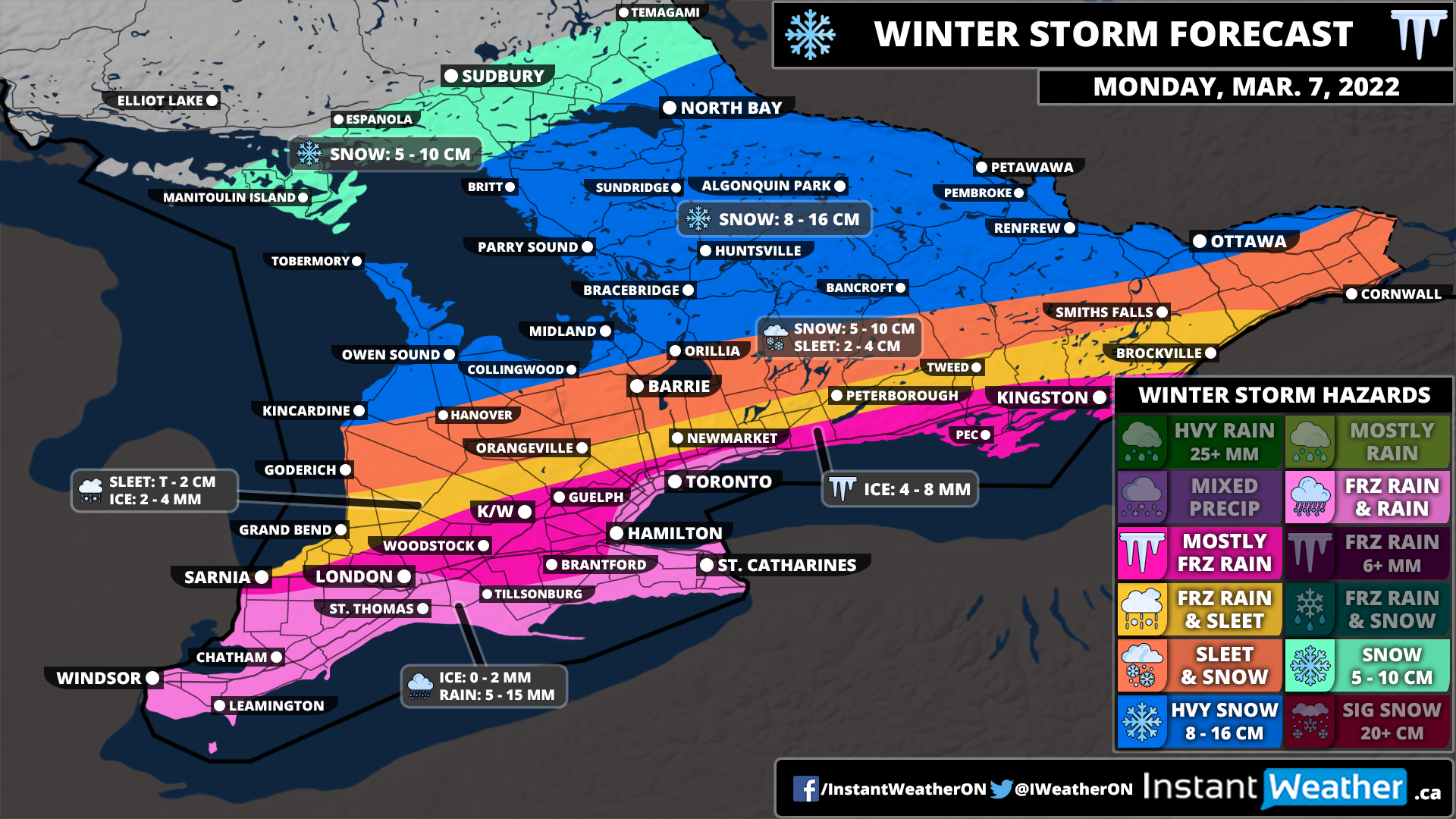
After a quick taste of spring-like weather across Southern Ontario on Sunday, we are expecting the return of wintery weather throughout the day on Monday. This is courtesy of a messy system set to bring a wide range of precipitation with heavy snow through much of Central Ontario and into the Ottawa Valley. Further south, the concern will be a fairly prolonged period of freezing rain for London, K/W, Guelph, GTA (away from the shoreline) and into the Kingston area. Those in Deep Southwestern Ontario and the Niagara region should see minimal impact from this storm as we expect temperatures will remain just above the freezing mark throughout the event.

The precipitation associated with this system will start to move into the region from the southwest during the mid to late morning hours on Monday. This includes a band of freezing rain stretching along the Hwy 401 corridor from London to Northwestern GTA at the height of the morning commute so if you have to travel, make sure to leave plenty of time and drive according to the conditions. It appears that locations through the GTA that are right along the lakeshore should stay just warm enough to avoid the freezing rain. This includes Hamilton, Burlington, Mississauga and Downtown Toronto. However, it’s right on the line and if temperatures end up just a degree or two colder then they could also see the freezing rain. We have more confidence in the Niagara region and along the Lake Erie shoreline which should stay predominantly rain with maybe a brief round of freezing rain (less than an hour).

Precipitation will spread further to the north as it encounters colder air around Lake Simcoe and into Eastern Ontario. As a result, the main precipitation type will be ice pellets with some freezing rain in the south and snow to the north mixing in at times. This includes Goderich, Orangeville, Barrie and Cornwall. The ice pellet mix will linger into the afternoon before clearly late Monday from west to east. Total snowfall accumulation here is a little more uncertain depending on exactly how prevalent ice pellets are with this storm. Right now, we’re going with a general 5-10cm, but the potential for slightly below or above the forecasted totals can’t be ruled out. For Grand Bend, Newmarket and Peterborough they could see a few hours of freezing rain in addition to the ice pellets.

A band of moderate to heavy snowfall from this system will stretch from Grey-Bruce through Muskoka and into the Ottawa Valley starting late Monday morning and continuing into the afternoon. The colder air will hold on here so we are expecting little to no mixing except maybe some ice pellets. Total snowfall accumulation will range from 8-16cm by the end of Monday. The snow will taper off by the evening or closer to midnight for Eastern Ontario. Colder air will flow in behind the system as it moves out by Monday late afternoon so don’t be surprised to see some light snow throughout Southern Ontario outside of the snow zone on our map. But accumulation should be minor as the snow will be quite wet and surfaces will still be wet from the earlier rainfall.

We could see some icy road conditions as temperatures drop well below the freezing mark overnight Monday. This may also further enhance the impact of the earlier freezing rain accretion as it won’t have a chance to melt in some locations before the cooldown occurs. Power outages even into Tuesday aren’t out of the question as tree branches and power lines break under the stress of the ice accretion. Thankfully we only expect 8mm of ice accretion at most from this system so overall impacts shouldn’t be too significant.

Early Taste of Spring Across Southern Ontario on Sunday With Double-Digit Temperatures, Damaging Wind Storm and Thunderstorm Risk

We are in for quite the wild ride when it comes to the weather across Southern Ontario over the next few days. The active weather will begin on Sunday as a system ushers unseasonably warm air into the region which will result in many areas seeing temperatures reach into the double digits for early Sunday. However, this blast of warm air will be accompanied by rain and even non-severe thunderstorms mainly during the morning on Sunday. We aren’t expecting a significant amount of rain so flooding shouldn’t be a major concern, but areas that experience thunderstorm activity could see locally higher rainfall totals. Looking at general rainfall totals ranging from 5-10mm with locally 10-20mm in those locations that see the thunderstorms.

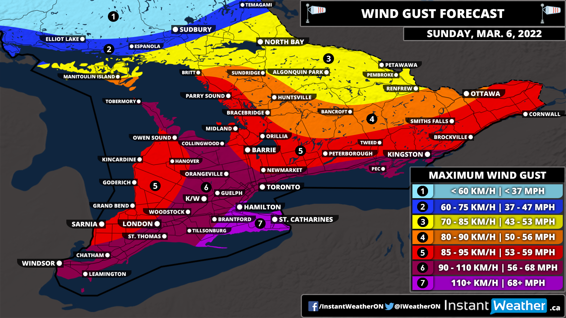
The biggest story from this system will certainly be what is shaping up to be a potentially significant wind storm across Southern Ontario. These strong wind gusts will start to pick up in Southwestern Ontario just after midnight and continue to persist throughout the morning on Sunday. Later in the morning, we will see the damaging wind gusts expand further to the east including the Golden Horseshoe and into Eastern Ontario. We expect the worst of this wind storm will be felt during the late morning and early afternoon with the winds weakening later in the day as we head into the evening hours.

Current indications suggest that the strongest wind gusts will be found through the Niagara and Hamilton region. Especially around the Grimsby and Niagara-on-the-Lake area that borders the Lake Ontario shoreline. We believe that wind gusts here could exceed 110km/h at the height of the event and potentially even approach the 115-125km/h range. This could result in very severe wind damage throughout the region including the possibility of power outages. Be sure to secure anything on your property that could be blown away!

Those around the Lake Ontario and Erie shoreline along with through the higher elevations of the Dundalk Highlands can expect wind gusts of between 90-110km/h. This includes Deep Southwestern Ontario (Windsor, Chatham and London) along with the K/W, GTA and Kingston regions. The rest of Southwestern Ontario into parts of Central/Eastern Ontario are looking at wind gusts ranging from 85-95km/h. Less of an impact when it comes to the strong wind gusts are expected further to the north and west including Algonquin Park, North Bay and Sudbury which will still see strong wind gusts but shouldn’t reach severe levels.

As mentioned, this system will temporarily boost the temperatures across Southern Ontario with the warmest air from Windsor through London and around the GTA. The daytime temperature here will range from 14 to 18°C and we can’t even rule out one or two locations even flirting with the 20s, but it’s questionable.

Don’t expect these warm temperatures to last all day as the daytime high will likely be hit sometime during the late morning or early afternoon and quickly drop back into the single digits later in the day. The rest of Southern Ontario except for northern parts of Central Ontario and Northeastern Ontario will see a daytime high in the low to mid-teens.

This will be short-lived as below-freezing temperatures will return to much of Southern Ontario by Sunday night! The drop in temperature to below freezing appears to be fairly gradual so a flash freeze shouldn’t be a threat, but that could change. However, we are watching what could be an impactful winter storm across Southern Ontario on Monday and Tuesday. This also includes the risk of prolonged freezing rain for a large portion of the region. More details on that are to come on Sunday once the exact impact is more certain.

There will also be a cold side to this system, but for the most part, the wintery precipitation will stay to the north of Southern Ontario. Although there is a brief risk of freezing rain during the very early morning hours on Sunday for Northern Central Ontario and into the Ottawa region. This will quickly come to an end as temperatures rise well above the freezing mark later in the morning. More prolonged freezing rain is expected through Northeastern Ontario including Elliot Lake, Sudbury and North Bay. See our Northern Ontario forecast for more details on the impacts this system will have there.

Southern Ontario: Snowfall Outlook for Friday, February 25, 2022

Forecast Discussion

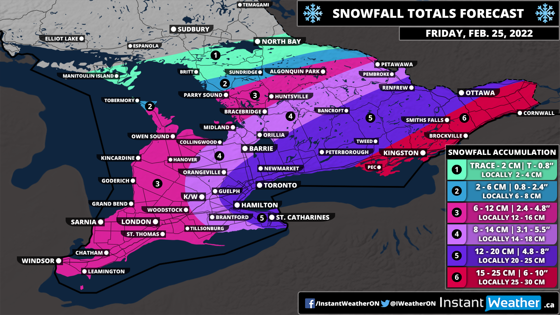
We are monitoring a system that now appears poised to bring more snowfall than previously indicated on Friday. The latest data has boosted the snow totals across Southern Ontario with widespread 10-15cm and even upwards of 20cm for parts of Eastern Ontario.

The first bands of precipitation have already reached the southwestern part of the province. Light to moderate snow will continue to spread to the northeast throughout the predawn hours on Friday and intensify through the GTA by 2-6 am and Central/Eastern Ontario by the late morning.

The timing of this event couldn’t be any worse for those commuting on Friday morning with the heaviest snow occurring around sunrise. This event will be more of a persistent moderate snowfall with hourly accumulation ranging from 1-3cm. As a result, travel will still be heavily impacted, but road crews should be able to keep up for the most part and shouldn’t be overwhelming.

Blowing snow could be an issue as 40-60km/h wind gusts combined with this light powdery snow are a recipe for reduced visibility. Based on the timing, school bus cancellations can’t be ruled out mainly in the more rural school boards as they tend to be more sensitive to weather conditions. See our snow day forecast here. Travel according to the conditions and if possible, delay any travel until later in the day. This will be a fairly fast-moving snowfall event as we expect it will taper off by the late morning for Southwestern Ontario and mid-afternoon in Eastern Ontario.

The biggest change compared to our initial forecast is the expected snowfall total. We have moved most regions up a level on our legend except for Southwestern Ontario. The highest totals will be found through Extreme Eastern Ontario including Kingston, Brockville and Cornwall with between 15-25cm of snow possible. The 12-20cm zone is now quite expansive including the rest of Eastern Ontario, parts of Central Ontario and around the Golden Horseshoe.

Lower amounts are expected for Southwestern Ontario which should top out at somewhere around 6-12cm. Totals will decrease even further to the northwest with Northeastern Ontario only expected to pick up a few centimetres of fresh snow if anything at all.

It should be mentioned that this event does appear to have a significant lake enhancement element associated with it. What does this mean? Well, snowfall accumulation with these events tends to have quite an uneven distribution. For example, one location could see 20+cm of snow while just down the road there is less than half of that. Don’t be surprised to see some locations overachieve the forecast, but we believe it’s more realistic to focus on the overall general totals.

Conditions will rapidly improve later in the day on Friday leading into what appears to be a quiet weekend. May see some scattered flurries on Sunday for Central and Eastern Ontario, but nothing more than a few centimetres.

Southern Ontario: Snowfall Outlook for Friday, February 25, 2022

Forecast Discussion

A system is expected to bring widespread accumulating snow throughout Southern Ontario beginning early Friday morning. The first bands of precipitation will reach regions around Lake Erie sometime around the midnight hour. Light to moderate snow will continue to spread to the northeast throughout the predawn hours on Friday reaching the GTA by 2-4 am and Central/Eastern Ontario by the late morning.

The timing of this event couldn’t be any worse for those commuting on Friday morning with the heaviest snow occurring around sunrise. This event will be more of a persistent moderate snowfall with hourly accumulation ranging from 1-3cm. As a result, travel will still be heavily impacted, but road crews should be able to keep up for the most part and shouldn’t be overwhelming.

Blowing snow could be an issue as 40-60km/h wind gusts combined with this light powdery snow are a recipe for reduced visibility. Based on the timing, school bus cancellations can’t be ruled out mainly in the more rural school boards as they tend to be more sensitive to weather conditions. Travel according to the conditions and if possible, delay any travel until later in the day. This will be a fairly fast-moving snowfall event as we expect it will taper off by the late morning for Southwestern Ontario and mid-afternoon in Eastern Ontario.

We are looking at the highest snowfall totals from this event through Eastern Ontario along with the Niagara/Hamilton region due to lake enhancement off Lake Ontario. General accumulation here will range from 12-20cm with locally up to 25cm possible. For the rest of the Golden Horseshoe and into parts of Central Ontario, we can expect totals of between 8 and 14cm although a few locations particularly through the GTA could exceed the 15cm mark. Lower amounts are expected for Southwestern Ontario which should top out at somewhere around 6-12cm. Totals will decrease even further to the northwest including Parry Sound and Algonquin Park only expected to pick up a few centimetres of fresh snow if anything at all.

It should be mentioned that this event does appear to have a significant lake enhancement element associated with it. What does this mean? Well, snowfall accumulation with these events tends to have quite an uneven distribution. For example, one location could see 20+cm of snow while just down the road there is less than half of that. Don’t be surprised to see some locations overachieve the forecast, but we believe it’s more realistic to focus on the overall general totals.

While there is a fair amount of confidence in the models with this forecast, we may have to make adjustments on Thursday. If the track shifts either to the north or south we would have to also shift our forecast based on that change. However, we shouldn’t see any major changes to the forecast.

Another Stormy Day

Valid: Thurs Feb 3 - Fri Feb 4

Another Stormy Day

What is interesting about this storm is that it is not on the weekend. Other than that, PEI is in the path for a large blast of winter weather starting on Friday. We will be looking at significant snow, and some areas of the province will be looking at ice pellets. With the current path, areas around Wood Islands could see some freezing rain late Friday night.

TIMING:

Current models are indicating that on Thursday, during the day, across PEI we will see some rain. The system starts to arrive in PEI just after midnight in the early morning hours of Friday. It will snow heavy during the daylight hours and the majority of the snow will be down by Friday evening. There will continue to be lingering flurries through the day Saturday giving us an additional 2-5cm.

Throughout the storm, especially during the early morning hours of Friday, we can expect to see ice pellets in Kings and parts of Queens County. This will be mixing in with the snow.

TOTAL AMOUNTS ACROSS THE PROVINCE:

The below accumulations are what we can expect to see on Friday:

SNOWFALL

Prince County – 30-40 cm

Queens County – 30-40 cm

Kings County – 30-40 cm (areas from Stratford to Georgetown to the North Shore and East Point)

Kings County - 20-30 cm (areas from Stratford to Georgetown to Wood Islands)

WIND: Winds will not be as large of a factor with this system, however, they will still be significant enough to blow the snow around causing some white out conditions. Overall, winds should be 40-60 km/h from the north. Saturday will see the winds continue in the 40-60 km/h range.

TEMPERATURE: Thursday we will see temperatures just above the freezing mark in the 3-5 C range. They will begin to drop later in the evening on Thursday and from the early morning hours of Friday through to Saturday morning temperatures should be around the -3 to -5 C range. By noon on Saturday, temperatures will begin to drop and by evening we could see them dipping to -10 to -15 C. Sunday could see temperatures dipping even further to -15 to -20 C.

Any shift in the front could greatly vary the precipitation types and quantities. We will continue to monitor this system and keep you updated with any significant changes.

The significant snowfall, combined with the consistent winds and the already high snowbanks along the roadways will cause white out and hazardous driving conditions during Friday and into Saturday. Please stay home unless absolutely necessary. Always adhere to the recommendations of the RCMP and PEI Public Safety.

As always, be safe and let us know what you are experiencing in your areas.

Storm chip Probability: 100% (again)

IWPE Team (Mike S, Harry S)

Another Weekend, Another Winter Storm

Valid: SAT, JAN 29, 2022

What comes after 5 days of work???? A winter storm. PEI is in the bullseye for yet another large blast of winter weather and once again, it is on a Saturday. We will be looking at significant snow, and some areas of the province will be looking at ice pellets, freezing rain and rain on the tail end of the system.

TIMING:

Friday night into early Saturday morning, we will see a light dusting across the province. The ‘real’ system starts impacting the entire province shortly after daybreak on Saturday. The heaviest bands of snow will arrive during the afternoon hours and by evening, the majority of the snow from this system will be down across the Island.

We should see a brief change over from snow to sleet in the evening on Saturday and Queens county could also see a little bit of freezing rain. Kings County can expect to see the snow change over to sleet and then to rain by early evening, and the rain may push across to Queens and Prince counties briefly around midnight Saturday.

TOTAL AMOUNTS ACROSS THE PROVINCE:

The below accumulations are what we can expect to see on Saturday:

SNOWFALL

Prince County – 20-30 cm (higher accumulations closer to Queens County)

Queens County – 30-40 cm

Kings County – 20-30 cm (areas around Wood Island may only see 15-20cm)

RAINFALL

Prince County – 1-5mm

Queens County – 1-5 mm

Kings County – 5-10mm

WIND: Winds will be a factor with this system. It is a fairly fast moving system and what that means is the higher wind gusts will be over a shorter period of time. Winds will be from the North / Northeast and will gradually increase throughout Saturday morning and should start diminishing late Saturday night. The stronger winds will occur between 2pm and 8pm Saturday. Overall, wind should be 40-60 km/h with gusts of 70-90 km/h during the late afternoon hours. Prince County could see some wind gusts reaching close to 100km/h near supper time on Saturday.

TEMPERATURE: We should be starting the day on Saturday with temperatures around the -5 to -10 C range and as the day progresses we will see those temperatures rise above freezing to around 2-4 C by Saturday evening and then temperatures will again decrease to -5 to -10 C area by noon time on Sunday.

Any shift in the front could vary the precipitation types and quantities. We will continue to monitor this system and keep you updated with any significant changes.

Winds and snow will cause white out and hazardous driving conditions during Saturday. Be prepared for power outages. Please exercise caution if you are on the roads. Please stay home unless absolutely necessary. Stranded vehicles are a hazard to those in them as well as emergency and road crews. If you do not need to drive, stay home and eat chips. Always adhere to the recommendations of the RCMP and PEI Public Safety.

As always, be safe and let us know what you are experiencing in your areas.

Storm chip Probability: 100%

IWPE Team (Mike S, Harry S)

Another Winter Storm Heading for PEI

Valid 14 Jan, 2022

…and just like that, our second winter storm of 2022 is heading our way. This one has a number of the same characteristics of last week's storm - significant snow and high winds.

TIMING:

Prince County should see this as a snow event only with the snow starting late afternoon on Friday. Kings County, and possibly most of Queens County will see this system start as rain around lunch time on Friday. By early evening that rain will have a change over to snow in Queens County. We may see some ice pellets in Queens County during that changeover. In Kings County, the changeover will see ice pellets and possibly see some freezing rain. By 10pm, it should be an all snow event. Snow will continue through the overnight into Saturday and will diminish to flurries some time Saturday afternoon.

TOTAL AMOUNTS ACROSS THE PROVINCE:

The below snowfall accumulations are what we can expect to see from Friday evening to Saturday afternoon:
SNOWFALL

Prince County – 30-40 cm
Queens County – 30-40 cm
Kings County – 20-30 cm

WIND: Again, winds will be a factor with this system. Winds will be from the North / Northwest and will gradually increase through the evening hours of Friday and should start diminishing Saturday around noon. The stronger winds will occur between 2am and 10am Saturday. Overall, wind should be 50-70 km/h with gusts of 80-100 km/h n

TEMPERATURE: Friday will start with temperatures hovering around the freezing mark and by supper time Friday, temperatures will begin to go down and will reach lows near -10 by Saturday evening.

Any shift in the front could vary the precipitation types and quantities. We will continue to monitor this system and keep you updated with any significant changes.

Winds and snow will cause white out and hazardous driving conditions. Be prepared for power outages. Please exercise caution if you are on the roads. Saturday will be a day that travel is not recommended. If you do not need to drive, stay home and eat chips. Always adhere to the recommendations of the RCMP and PEI Public Safety.

As always, be safe and let us know what you are experiencing in your areas.

Storm chip Probability: 100%

IWPE Team (Mike S, Harry S)

Snow Squalls To Bring Up to 20cm of Snow to Areas East of Lake Huron and Georgian Bay Between Thursday Evening and Friday Morning

Colder air returns to Southern Ontario after a brief shot of mild weather which has resulted in the development of lake effect snow late Thursday and is expected to further intensify into squalls by the evening.

The focus of these squalls will be on a zone east of Georgian Bay with the heaviest accumulation in locations such as Parry Sound, Port Carling, Bracebridge, Gravenhurst and Miden. There will also be some less organized squalls off Lake Huron with higher amounts further inland over the Hanover, Minto, Wingham and Listowel area. Total accumulation could approach the 20cm mark locally with general amounts around 10-15cm.

Those closer to the shoreline will see lower amounts due to temperatures staying above the freezing mark which will mean the snow will struggle to accumulate. The lake effect activity will drift southward during the morning on Friday bringing the heavy snow to locations such as Collingwood, Wasaga, Angus, Goderich and Stratford. However, the squalls won’t last long until fizzling out by the afternoon hours so accumulation should be limited to around 5cm with maybe some localized pockets picking up to 10cm.

Snow squalls can cause quite dangerous driving conditions through the affected regions with near-zero visibility and rapid snowfall accumulation. It is highly recommended that you avoid travel during the evening and overnight hours if you can. Otherwise please leave lots of time to get to your destination safely! The morning commute will likely be impacted, but conditions should be a little better than compared to the overnight hours. School bus cancellations are possible Friday morning which we will cover in our snow day forecast to be issued Thursday evening.

Midweek Snowstorm To Bring Up to 30cm of Snow to Parts of Northwestern Ontario Between Tuesday and Wednesday

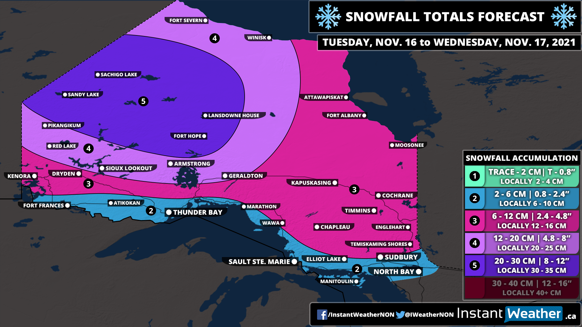
The low-pressure system currently bringing record-breaking flooding to parts of British Columbia will race across the Prairies and start to affect Northwestern Ontario starting Tuesday morning with the initial bands of precipitation. Instead of rain, we are mainly looking at snowfall which could come down quite heavy at times. The system will be a lot weaker than when it made landfall in BC so this won’t be any more than a fairly typical snowstorm for the region.

We will see the worst conditions from this storm through Sandy Lake and Sachigo Lake during the later part of Tuesday and into Wednesday morning. Heavy snow combined with strong wind gusts up to 50-70km/h could create very poor travel conditions. Snow will continue during the day on Wednesday, but it won’t be as intense with the heavier precipitation being found along the Quebec border. There could be the risk of some freezing rain just north of Sudbury during the morning on Wednesday although confidence in that is low. The system will finally exist in the region by the end of Wednesday, but a few flurries may linger into Thursday.

We’re looking at around 20-30cm of snowfall accumulation through the hardest hit zone including Sandy Lake, Sachigo Lake, Fort Hope and Lansdowne House. A few localized areas could pick up more than 30cm. Other parts of Northwestern Ontario can expect around 12-20cm with between 6-12cm for the rest of Northern Ontario away from the shoreline of Lake Superior and Georgian Bay. We will likely see some rain along the shorelines which will reduce potential accumulation.

Snow Squalls Brings Snowy Blast to Parts of the Snowbelt Around Lake Huron and Georgian Bay on Monday With Locally Up to 15–25cm Possible

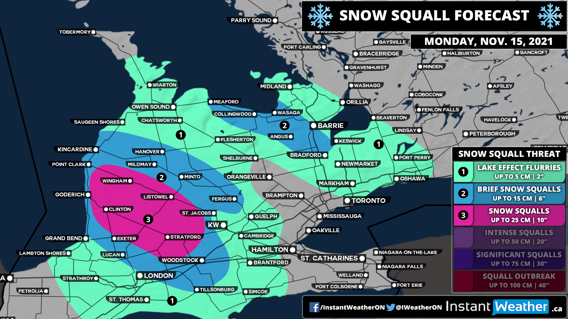
The start of the week through parts of the traditional snowbelt southeast of Lake Huron and Georgian Bay will get off on a snowy note as some organized lake effect snow and localized squalls are expected to develop early Monday. Current indications suggest that a fairly strong squall could develop off Lake Huron during the mid to late morning hours on Monday stretching from Goderich and further inland towards Stratford.

In addition to this, we will see some lake effect activity off Georgian Bay during the late morning affecting the Collingwood and Wasaga area along with the Hwy 400 corridor between Barrie and Bradford. This will continue throughout the day and may even linger into the overnight hours into predawn Tuesday. However, it should dissipate by mid-Tuesday morning so it shouldn’t have a significant impact on the morning commute.

As is typical with lake effect snow events, predicting the exact accumulation is very tricky as it depends on how strong the bands are and where exactly they lock-in. We do believe there is the potential that someone just to the southeast of Goderich including Clinton, Wingham, Listowel and Stratford could pick locally up to 20-25cm, but general snowfall amounts around 10-20cm are more likely. Surrounding regions including the Lake Huron shoreline where temperatures will be slightly warmer can expect between 5-10cm with locally up to 15cm. The Collingwood and Angus corridor could see around 10-15cm in the hardest-hit locations. The City of Barrie should escape the worst although the south end of the city could pick up near 10cm with around 5cm in the north end.

Travel conditions throughout the day on Monday will likely be very poor within the affected regions so be sure to take your time and maybe avoid travelling until conditions improve. Snow squalls can cause rapid reductions in visibility and make it hard to adjust to conditions.