First Multi-Day Winter Storm of the Season Could Bring Up to 20-30cm of Snow to Parts of Northeastern Ontario Starting Monday

NOTE: You can click on the map to open a zoomable image which will be easier to read.

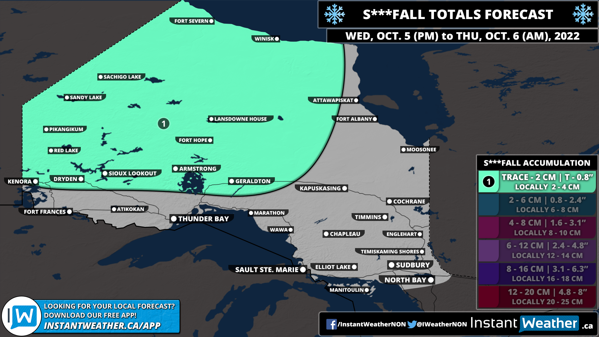
Mother Nature isn’t wasting any time with giving a taste of wintery weather this week across parts of Northern Ontario. The calendar might still say October, but the next few days will feel like we skipped a whole month right into late November. While most parts of Northern Ontario have already seen the season's first flakes, we are watching a multi-day system that could bring accumulating snowfall to a wide swath of Northeastern Ontario. The snow will start for some on Monday and continue on and off with multiple waves over through Tuesday and into Wednesday with total accumulation over the three days adding up to 20-30cm in the hardest hit areas.

A low-pressure system is expected to stall over the Great Lakes starting Monday which will provide a steady stream of precipitation across Northern and Southern Ontario over the next few days. In addition to the multiple waves of precipitation, some colder air will flow in from the west starting Monday dropping temperatures to near or slightly below the freezing mark through Northern Ontario. With temperatures near the freezing mark, it is likely that precipitation will come down in the form of wet snow for the Kapuskasing and Chapleau region starting as early as Monday afternoon.

It’s important to note that this is very temperature dependent which will affect exactly how much snow a particular region receives on the ground. The precipitation may also change back to a rain/snow mix during the day on Tuesday as temperatures warm up slightly before going back below the freezing mark. Not to mention that the ground is still fairly warm so it may take some time before the snow starts accumulating and thus reducing actual accumulation. So this forecast isn’t saying that a particular location will have 20-30cm of snow on the ground by Wednesday, but rather that total snowfall over the three days will add up to that and it’s hard to say exactly how much will melt.

Snow will come in multiple waves with the heaviest snow expected Tuesday afternoon and lingering into Wednesday morning. The snow should taper off by the middle of the day on Wednesday, but scattered flurries may continue into Thursday. Those closer to the Quebec border and up around James Bay will see slightly warmer temperatures so precipitation will come in the form of rain for the most part. However, a few hours of heavy snow is possible late Tuesday into Wednesday as the colder air finally spreads further east.

As this system extends multiple days, it’s possible that the forecast may change as we get closer and see how the first part of the precipitation develops. We will be monitoring the latest data and updating our forecast with a more precise expected snowfall accumulation map by Monday. As we’ve mentioned throughout the forecast, the confidence in this event is low as is typical with the season’s first major snowfall. So be aware that changes are likely with our final forecast.

Here is another advertisement so we can pay other bills:


Chilly Start to Thanksgiving Weekend With Potentially the First Flurries of the Season Overnight Friday in Parts of Southern Ontario

NOTE: You can click on the map to open a zoomable image which will be easier to read.

So far we’ve seen a fairly mild start to October across Southern Ontario with daytime temperatures well into the twenties for multiple days in a row this week. But don’t be fooled, winter is just around the corner and that reality will quickly set in over the next 24 hours as a cold front sweeps across the region. This will usher in much colder air into Southern Ontario with daytime highs in the mid to upper single digits on Friday. Lake effect showers will also be ongoing around Georgian Bay and Lake Huron throughout the day on Friday. Around 5-15mm of rainfall is expected for those southeasts of the lakes including Sarnia, Grand Bend, Collingwood and Barrie.

As we head into Friday night, the temperature is expected to further drop and come close to the freezing mark in some locations. Particularly the higher elevations of the Dundalk Highlands (Orangeville, Shelburne etc.), Northern Muskoka and Haliburton Highlands will see temperatures near or slightly below the freezing mark. As a result, there is a chance that the lingering lake effect showers throughout the region could come down in the form of wet flurries overnight Friday into Saturday morning. This includes parts of Huron and Grey-Bruce counties away from the shoreline, Hanover, Meaford, Blue Moutain, Shelburne and Orangeville overnight. And the chance will shift towards the Muskoka, Haliburton and Bancroft regions in the morning as the bands of lake effect precipitation move to the north.

It’s important to emphasize that this forecast is very preliminary and confidence is low since it really depends on the exact air temperature. Not everyone within our forecast will see the first snow of the season. And even if we do see snow, it will likely melt on contact and be gone by sunrise so unless you wake up early in the morning, you won’t even know that it snowed.

NOTE: You can click on the map to open a zoomable image which will be easier to read.

Despite the chilly (and potentially snowy) start to the Thanksgiving Weekend, we are expecting fairly decent weather for your Thanksgiving gatherings on Sunday. Temperatures during the day will range from the lower to mid-teens across Southern Ontario. Some rain will move through Central and Eastern Ontario during the early morning hours, but it should be done by the early afternoon. The rest of Southern Ontario will see a mix of sun and clouds for your Thanksgiving Sunday so maybe consider outdoor gatherings and take advantage of that fresh fall air!

For those that celebrate on Monday, the forecast will be basically a carbon copy of what we see on Sunday with temperatures slightly warmer and fewer clouds. On behalf of the entire Instant Weather team, we’d like to wish you a Happy Thanksgiving! We are incredibly grateful for your support throughout these years as we try to bring more context to the weather.

Here is another advertisement so we can pay other bills:


What The F...lurries? First Widespread Snowfall of the Season Starting Tonight Into Friday Morning Across Northeastern Ontario

NOTE: You can click on the map to open a zoomable image which will be easier to read.

It might still be a few weeks away from Halloween, but our forecast for this Thanksgiving Weekend is downright scary for those not ready for a taste of winter weather. Yes, it’s that time of the year when we must say the dreaded f-word for the first time! Parts of Northeastern Ontario are set to see the first flakes of the season starting Thursday evening and continuing into early Friday morning. Current indications suggest that the snow could come down heavy enough to lead to minor accumulation and as a result, some locations might be surprised with up to a few centimetres of that wet fluffy stuff on the ground as you wake up Friday morning.

The potential for wet snow will begin early this (Thursday) evening as a sharp cold front cuts across Northeastern Ontario. This will allow for temperatures to drop near the freezing mark over the next few hours causing the ongoing rainfall to slowly transition over to wet snow by tonight. Persistent light to moderate snowfall will continue overnight for locations such as Chapleau, Timmins, Cochrane and Englehart.

Depending on how cold the temperature can get and the intensity of the snowfall, some of these locations may wake up to some accumulation, but it will quickly melt as temperatures warm above the freezing mark after sunrise. Further to the southeast through the Elliot Lake, Sudbury and North Bay regions, they could also see some flurries overnight and early Friday morning, but the air temperature is still expected to remain slightly above the freezing mark which means any snow will melt on contact.

Heading into the Thanksgiving Weekend, it looks like the cold air will be sticking around at least for the next few days. Overnight lows will continue to flirt with the freezing mark all weekend. This also means that there is the chance for more wet flurries, although it appears that most of the activity will be continued to Far Northern Ontario like Fort Severn, Winisk and Attawapiskat. We should see somewhat of a warm-up by Monday/Tuesday with the potential for double-digit highs for some parts of Northern Ontario.

Here is another advertisement so we can pay other bills:


Autumn Sets In Across Ontario With a Significant Cooldown & the First Snowfall of the Season

NOTE: You can click on the map to open a zoomable image which will be easier to read.

As we head deep into the fall season with the arrival of October, it’s expected to see some colder air and even the risk of the familiar white flakes we haven’t seen in a while. For most, it still comes as a shock especially considering how warm the start of fall has been across the region. The rude awakening will occur later this week as a cold front ushes in colder temperatures across Northern and Southern Ontario. You still have time to get out there and enjoy the nice fall weather - double-digit daytime highs are expected to continue on Wednesday for all of Ontario and Thursday for Southern Ontario.

We will see the colder air making its way into Northwestern Ontario by late Wednesday as the cold front moves through. The cold front will also be accompanied by some light precipitation, initially coming down as rain showers. However, with temperatures expected to drop to near the freezing mark overnight Wednesday into Thursday morning, it could transition over to some wet snow. This is predominantly for Northwestern Ontario along the Manitoba border where the temperatures will be cold enough for snow. We don’t expect much in terms of accumulation since the ground will still be fairly warm and any snow will melt on contact.

NOTE: You can click on the map to open a zoomable image which will be easier to read.

The cold front will continue to progress to the southeast throughout the day on Thursday. This will bring the risk of some wet snow to parts of Northeastern Ontario overnight Thursday as temperatures hover near the freezing mark. There is some indication that the snow could be quite heavy at times so it may leave some minor accumulation through Chapleau and Timmins with up to 2-4cm possible. However, this is questionable so it’s not guaranteed to accumulate and will come down to exactly how cold it can get.

NOTE: You can click on the map to open a zoomable image which will be easier to read.

For Southern Ontario, the story for most of the week will be almost perfect fall weather with mild temperatures in the high teens or low twenties and not much in terms of rain. By Friday this will change with the arrival of the cold front early Friday which will result in a rapid drop in temperatures. The daytime high on Friday will be around 10 degrees colder than just 24 hours earlier! It will get even colder overnight into Saturday morning with many areas at or slightly below the freezing mark leading to the widespread risk of frost.

It appears that Southern Ontario should avoid the season’s first snowfall for the most part. There still could be some flurries early in the morning on Friday through North Bay and into Algonquin Park, but it shouldn’t be widespread. Temperatures will moderate somewhat heading into next week which should ensure we don’t get any snow just yet. It’s only a matter of time though and it does look colder towards the middle and end of October so there might be a chance for many areas to see their first flakes of the season.

Here is another advertisement so we can pay other bills:


Last Day of Summer on Wednesday to Feature Potentially Dangerous Thunderstorms Including Tornado Risk Across Southern Ontario

NOTE: You can click on the map to open a zoomable image which will be easier to read.


It appears that the last day of ‘astronomical’ summer (meteorological summer ended at the start of the month) will go out with a bang for parts of Southern Ontario. This is courtesy of a strong cold front expected to sweep across the region on Wednesday and spark off potentially widespread severe thunderstorms starting early in the afternoon and continuing throughout the day. There is some uncertainty regarding the exact timing and intensity of the storms, but the environment is certainly favourable for a widespread damaging wind event along with the risk of tornadoes.

Current data suggest that the target zone for the strongest storms will be around the Georgian Bay shoreline in Central Ontario. However, not all models show storms developing to take advantage of the prime environment or developing too early in the day when daylight heating hasn’t built up enough. The most likely scenario appears to be a cluster of discrete storms developing over Lake Huron or Georgian Bay around the noon hour and tracking to the southeast throughout the early afternoon. This is when we believe the tornado risk will be at the highest as they come onshore around the Kincardine, Owen Sound, Collingwood, Barrie, Midland and Muskoka Lakes region between 12-2 PM (note: this timeframe is preliminary and may need to be changed). Large hail and damaging wind gusts are also possible from these storms.

As the storms continue to race across the region during the early afternoon, we expect to see the discrete cells slowly merge into a squall line with further development in Deep Southwestern Ontario. This means that the main threat will transition into a widespread damaging wind gust event as it tracks into the GTA and Niagara region by the mid to late afternoon. An isolated tornado still can’t be ruled out, but the risk is a lot stronger earlier in the day. It looks like Eastern Ontario will be spared from the worst of this severe threat, however, those in the far southeast including Belleville and Kingston could still be affected as the squall line tracks across Lake Ontario and into Upstate New York.

Keep in mind this is a very preliminary forecast as there is significant disagreement on storm development and exact timing which will determine the overall severity of these storms. It’s likely that we will have to make adjustments to the forecast based on the latest data from this evening and in the morning. While we’ve gone with a significant severe risk based on the environment, we may need to downgrade if it becomes apparent that storm development is more isolated or too early in the day. Be sure to check back on Wednesday for the very latest.

In addition to this, it will certainly feel like fall by the end of the week with colder air moving into Southern Ontario on Thursday and Friday. Some parts of our region will struggle to get above single digits as a daytime high on Thursday with a chill start on Friday morning as temperatures dip to near the freezing mark. We may even have to start talking about the risk of frost in higher elevations of Central and Eastern Ontario!


IMPORTANT: If storms start developing, we will likely be live-streaming via YouTube, Facebook, Twitter, and Twitch as we track every developing storm and notify those in the path of any rotation, tornado reports, damaging winds, and large hail on our free app Instant Weather and via our premium Text Message Alerts. If you don’t have PayPal, you can also subscribe to our text messages directly on our website, however, the PayPal option is automated so it will work immediately as we may not be able to get to everyone who subscribes via our website due to the fact that we have to enter those in manually.

Here is another advertisement so we can pay other bills:


FORECAST UPDATE: Widespread Severe Thunderstorm Risk for Monday Across Southern and Northeastern Ontario

NOTE: You can click on the map to open a zoomable image which will be easier to read.


As we mentioned in our preliminary forecast yesterday, there is a risk of severe thunderstorms across Southern Ontario for Monday afternoon and continuing into the evening/overnight hours. While the focus yesterday appeared to be the Lake Simcoe region and the Lake Huron shoreline, we have now expanded the severe risk into the Ottawa Valley. Current data indicates that storms may pop up further to the northeast than expected and combined with a very robust environment, they could become quite severe with all severe threats including tornadoes possible.

Heading into the afternoon, we will be watching two zones for the development of isolated storms through Central and Northeastern Ontario. Storms are expected to pop up around the Collingwood/Barrie area early this afternoon and track to the northeast through northern Kawartha Lakes, Bancroft and Renfrew/Pembroke. These storms have the potential to bring damaging wind gusts, large hail and an isolated tornado. Some models are hinting towards some storm development over Lake Ontario which could affect Prince Edward County and Kingston, but the potential isn’t high enough to warrant upgrading them to the next severe level.

NOTE: You can click on the map to open a zoomable image which will be easier to read.

Similarly, we also expect to see some development in the north around the Wawa and Kapuskasing area this afternoon and slowly track to the east towards the Quebec border. Locations like Timmins, Cochrane and Chapleau have the highest chance of a tornado, but the risk of a tornado can’t be ruled out throughout Northeastern Ontario including Sudbury, Elliot Lake and North Bay.

The squall line that was expected to affect the Lake Huron shoreline will still present a risk but is now expected to develop over Michigan and not reach our region until late evening. As a result, the main threat with this line will be very strong wind gusts (90-100km/h) stretching from Tobermory and all the way into the Windsor area. We have kept the tornado risk along the Lake Huron shoreline and into Deep Southwestern Ontario, but the environment won’t be as strong after sunset so it’s questionable at best. If we do see a tornado, it would likely be right along the shoreline as the storms make landfall late in the evening. It will continue to track to the east throughout the overnight hour, but the severe risk will diminish as the line slowly weakens after midnight.


IMPORTANT: If storms start developing, we will likely be live-streaming via YouTube, Facebook, Twitter, and Twitch as we track every developing storm and notify those in the path of any rotation, tornado reports, damaging winds, and large hail on our free app Instant Weather and via our premium Text Message Alerts. If you don’t have PayPal, you can also subscribe to our text messages directly on our website, however, the PayPal option is automated so it will work immediately as we may not be able to get to everyone who subscribes via our website due to the fact that we have to enter those in manually.

Here is another advertisement so we can pay other bills:


ONTARIO: Noisy Start to the Last Week of Summer With the Risk of Severe Thunderstorms and Tornadoes on Monday

NOTE: You can click on the map to open a zoomable image which will be easier to read.


It’s the time of the year when summer winds down and we have to start talking about the f-word. No, not that f-word (well not yet that is), but rather it’s the end of August which means fall is almost here! Meteorological autumn actually begins on Thursday as the calendar turns from August to September while the more standard astronomical autumn doesn’t begin for a few more weeks. Although we might be saying goodbye to summer, it doesn’t mean that Mother Nature is quite done with summer-like weather just yet! It certainly doesn’t feel like fall which will continue into Monday as we expect hot and humid temperatures across Southern Ontario. This has prompted Environment Canada to issue Heat Warnings for the Windsor-Essex and Niagara regions with the humidex making it feel into the upper thirties.

As we are all accustomed to, the hot weather also provides the perfect fuel for thunderstorms and that will be the case for Monday afternoon into the evening. This will all begin pre-dawn Monday as some decaying storms move into the region from Michigan. Based on the timing, we aren’t expecting any severe weather for Monday morning and it’s even questionable if we see any lightning. However, it will bring rain and cloud cover to Southern Ontario throughout the morning which will be key in setting the stage for severe storm development later in the day. If the morning rain can clear out early enough, it will allow for enough daylight heating to build and fuel the potential storms for the afternoon and evening. If it lingers around into the afternoon, this will push any development to later in the day when the environment will be less favourable for any storms to become severe.

At this point, we are assuming that the storms clear out early enough so our forecast is based on that. So keep in mind that confidence isn’t super higher and we may need to make adjustments by early Monday afternoon once we see what happens with the morning activity. We are watching two potential regions where storms could develop with the first round of storms popping up around the Collingwood and Hanover area during the mid-afternoon. These isolated cells will track to the northeast towards Lake Simcoe with all severe threats on the table including damaging wind gusts, large hail and even an isolated tornado that can’t be ruled out.

By the dinner hour, we expect to see some storms begin to fire up over Lake Huron and quickly form into a squall line by the early evening. Although there is some disagreement between the models with some showing the line forming over Central Michigan and not reaching our region until later in the evening. Exactly where this line forms will be critical in determining the risk it will pose to Southern Ontario. Should the storms develop over Lake Huron, they will reach the shoreline around 7-9 PM with all severe threats including a tornado possible. The line will slowly to the southeast throughout the evening and transition into more of a damaging wind risk with the hail and tornado risk diminishing further inland. We should see the severe risk come to an end by late evening as the line of storms weaken into non-severe thunderstorms and track into Eastern Ontario overnight.

For those in Eastern Ontario, we are watching the potential risk of severe thunderstorms for Tuesday afternoon and evening. It isn’t looking that widespread at this point, but still could be an issue. We will have more details as we get closer to Tuesday. As we mentioned, this forecast is preliminary and may need to be updated on Monday once we see how the morning precipitation plays out. Stay tuned and check back for the very latest!


IMPORTANT: If storms start developing, we will likely be live-streaming via YouTube, Facebook, Twitter, and Twitch as we track every developing storm and notify those in the path of any rotation, tornado reports, damaging winds, and large hail on our free app Instant Weather and via our premium Text Message Alerts. If you don’t have PayPal, you can also subscribe to our text messages directly on our website, however, the PayPal option is automated so it will work immediately as we may not be able to get to everyone who subscribes via our website due to the fact that we have to enter those in manually.

Here is another advertisement so we can pay other bills:

MONDAY: Environment Canada Forecasting a Tornado Risk for Monday, August 29, 2022

NOTE: You can click on the map to open a zoomable image which will be easier to read.

Environment Canada has highlighted a tornado risk for Monday, August 29th, 2022 in the “D” zone of the map, which includes parts of Southwestern Ontario, Central Ontario, and Northeastern Ontario. They’ve also highlighted a “Moderate” severe risk in “C” zone that covers much of southern Ontario. And Eastern Ontario seems to be left out for Monday’s severe risk on their forecast. However, seeing as we’re two days away from this event, the placement could shift some.

Environment Canada writes: “Organized areas of thunderstorms are expected to develop Monday afternoon and evening ahead of a cold front. These thunderstorms have the potential to become severe with wind gusts near 90 km/h, toonie size hail and 50 mm of rain. While there is a great deal of uncertainty, there appears to be the potential for tornadic development.”

Here’s another advertisement to pay other bills:

We at Instant Weather are working on our preliminary forecast for Monday’s storms and we’ll be posting it ASAP. To get notified when we post the forecast, download our free app Instant Weather on Apple or Android or subscribe to our premium Text Message Alerts via PayPal (easiest for our team) or if you’re not on PayPal, you can subscribe directly via our website either monthly or annually. We send out Environment Canada alerts instantly and also our own Instant Updates™ for rotation, tornado reports, damage reports, violent wind gusts, severe weather forecasts, livestream notifications, etc.

Below are location specific details from Environment Canada’s forecast. To clarify, these details are only currently available via an email list and are occasionally posted to their twitter account:

Location: Northern portions of southwestern Ontario as well as central Ontario.

Impacts: Strong wind gusts can toss loose objects, damage weak buildings and break branches off trees. Large hail can damage property. Localized flooring in low-lying areas is possible. Power outages are possible. Scattered lightning strikes.

Confidence: Low.

Description: Organized areas of thunderstorms are expected to develop Monday afternoon and evening ahead of a cold front. These thunderstorms have the potential to become severe with wind gusts near 90 km/h, toonie size hail and 50 mm of rain. While there is a great deal of uncertainty, there appears to be the potential for tornadic development.


Location: Portions of southwestern Ontario and the Golden Horseshoe.

Impacts: Strong wind gusts can toss loose objects, damage weak buildings and break branches off trees. Large hail can damage property. Localized flooring in low-lying areas is possible. Power outages are possible. Scattered lightning strikes.

Confidence: Low.

Description: Organized areas of thunderstorms are expected to develop Monday afternoon and evening ahead of a cold front. These thunderstorms have the potential to become severe with wind gusts near 90 km/h, nickel size hail and 40 mm of rain.


Location: Portions of northern and eastern Ontario.

Impacts: Strong wind gusts can toss loose objects and break branches off trees. Small hail can damage plants and crops. Isolated to scattered lightning strikes.

Confidence: Low.

Description: Thunderstorms are expected to develop Monday afternoon and continue into Monday evening. Some of these thunderstorm have the potential to be accompanied by strong wind gusts and small hail.


More details ASAP!

And finally a third advertisement to pay the remaining bills:

ONTARIO: Relief From Extreme Heat in Sight With Severe Thunderstorm Risk on Monday

NOTE: You can click on the map to open a zoomable image which will be easier to read.


After a sweltering weekend across Southern Ontario with the humidex making it feel into the 40s for many locations, we are expecting a welcoming cooldown on Monday. This is courtesy of a cold front that will sweep across the region later Monday which will also bring the risk of thunderstorms. For the most part, these storms should remain non-severe, however, the environment is favourable for a few severe storms to affect parts of Southwestern Ontario and into the K/W and Hamilton regions.

Current weather guidance shows the potential for a cluster of cells to develop over Lake Huron during the mid to late afternoon hours. These storms will slowly track to the southeast making landfall along the shoreline between Goderich and Sarnia. From damaging wind gusts and large hail to maybe even an isolated tornado, all types of storm threats can't be ruled out. The tornado risk is the strongest along the shoreline, particularly around the Grand Bend area, but this will depend on the exact strength of the environment at the time and where the storms make landfall. As we head into the evening hours, these storms will begin to transition into more of a wind and flash flooding risk for Windsor, Chatham, K/W and Hamilton as they continue to track to the southeast.

A few clusters of thunderstorms are also expected to develop through Central and Eastern Ontario during the afternoon and evening hours, but they should remain non-severe with heavy rainfall as the main threat. For the GTA and Niagara region, they will see some thunderstorm activity late in the evening from the Lake Huron cells, but they should be much weaker by this point and will pose much less of a threat compared to earlier in the day.

Please note that this forecast is based on the current data and is subject to change as we get closer to the event. While we try our best to be as accurate as possible, forecasting severe weather is tricky and it’s impossible to be perfect. We will continue to go over the latest data and may make adjustments to the forecast sometime early on Monday. Stay tuned and check back for the latest information!


IMPORTANT: If storms start developing, we will likely be live-streaming via YouTube, Facebook, Twitter, and Twitch as we track every developing storm and notify those in the path of any rotation, tornado reports, damaging winds, and large hail on our free app Instant Weather and via our premium Text Message Alerts. If you don’t have PayPal, you can also subscribe to our text messages directly on our website, however, the PayPal option is automated so it will work immediately as we may not be able to get to everyone who subscribes via our website due to the fact that we have to enter those in manually.

Here is another advertisement so we can pay other bills:


Isolated Severe Thunderstorm Risk This Afternoon & Evening (Mon, Aug 1, 2022)

NOTE: You can click on the map to open a zoomable image which will be easier to read.

Monday, August 1st, 2022:

This afternoon and evening has the potential to bring with it isolated severe thunderstorms. By isolated, we mean the majority of our community will not see severe thunderstorms today. However, those who do may experience hail (1-2cm), damaging wind gusts (90km/h+), frequent lightning, and isolated flooding. Isolated tornado activity cannot be ruled out and we’ll be watching very closely for any rotation on radar or any reports from our extraordinary community! The main risk is in Southwestern Ontario and areas highlighted in Orange, perhaps extending towards Central Ontario and areas south and southeast of Lake Simcoe. We didn’t highlight Niagara in a severe risk but a rouge severe thunderstorm heading in that direction isn’t entirely out of the realm of possibilities. Muskoka, Northeastern Ontario, and isolated parts of Eastern Ontario have some isolated severe risk but overall, the severe thunderstorms risk in those areas are is low.

IMPORTANT: We’ll likely be livestreaming via YouTube, Facebook, Twitter, and Twitch, tracking every developing storm and notifying those in the path of any rotation, tornado reports, damaging winds, and large hail on our free app Instant Weather and via our premium Text Message Alerts. If you don’t have PayPal, you can also subscribe to our text messages directly on our website, however, the PayPal option is automated so it will work immediately as we may not be able to get to everyone who subscribes via our website due to the fact that we have to enter those in manually.

Here is another advertisement so we can pay other bills:


Long story short, we’ll be watching closely and please have a plan, especially in southwestern Ontario for some isolated severe weather this afternoon.

Overnight, Morning, Afternoon & Evening Severe Thunderstorm Potential (Sun, July 24, 2022)

NOTE: You can click on the map to open a zoomable image which will be easier to read.

Overnight: An overnight MCS (Mesoscale Convective System) of severe thunderstorms is likely overnight in deep southwestern Ontario. It’s expected to begin sometime after midnight and could cause damaging wind gusts, small hail, isolated flooding and frequent lightning. A brief tornado isn’t entirely out of the question in Essex County, Chatham-Kent regions, etc. Having said all of this, some models suggest this particular MCS storm system could weaken as it reaches our region. We’ll be watching closely!

Morning: Another line of storms will move after the first round and this show should up between 4am and 7am, again moving in from Michigan into southwestern Ontario. This morning line could potentially be stronger than the overnight MSC and the same risks will be present from damaging winds, torrential rain, hail, lightning, isolated flooding and again, an isolated tornado cannot be entire ruled out.

Here is another advertisement so we can pay other bills:

Afternoon: We should see widespread thunderstorms in the afternoon through a large swath of the region. There will be a mix of non-severe and severe storms and some of the strongest signals could be northwest, north, and northeast of Lake Ontario. It could get quite messy with widespread precipitation in many locations. All severe risks remain on the table though this period.

Evening: Some data is suggesting the strongest storms of the day could arrive in the evening hours (6pm - 9pm) in southwestern Ontario and push east into areas like Hamilton and parts of the GTHA and Niagara.

Tornado Risk: We’ve only covered the orange (3) areas in a tornado risk on our map as that area has the best chance. However, an isolated tornado occurring in the yellow (2) isolated severe risk areas cannot be entirely ruled out.

IMPORTANT: We’ll be with you every step of the way and we may or may not livestream via YouTube, Facebook, Twitter, and Twitch. Regardless of if we decide to stream or not, we’ll be tracking every developing storm and notifying those in the path of any rotation, tornado reports, damaging winds, and large hail on our free app Instant Weather and via our premium Text Message Alerts. If you don’t have PayPal, you can also subscribe to our text messages directly on our website. However, the PayPal option is automated so it will work immediately. As we have to enter the subscriptions on our website in by hand, we may not be able to get to everyone who subscribes before we get tied up with tracking these storms.

More details ASAP!

Significant Severe Thunderstorm & Tornado Risk (Wed, Jul 20, 2022)

NOTE: You can click on the map to open a zoomable image which will be easier to read.

Wednesday, July 20th, 2022:

Potentially two or even three rounds of widespread severe thunderstorms are expected to move through southwestern Ontario this afternoon and move east through evening hours into areas like the GTHA, Central Ontario, Niagara, Northeastern and Eastern Ontario. Several tornadoes would not be out of the question and perhaps even one or two strong tornadoes. Large hail (1-3cm), damaging wind gusts (120km/h+), frequent lightning, and isolated flooding are all on the table. Environment Canada has even issued a “High” risk and have now issued Tornado Watches. Remember, “Watch for a Warning”. Watches come first, warnings mean take shelter.

IMPORTANT: Please, take a deep breath. Please, do not panic. This isn’t the 1980’s where you didn’t find out about a tornado until hours after it happened. Our team will be live with you every step of the way on Wednesday via YouTube, Facebook, Twitter, and Twitch tracking every developing storm and notifying those in the path of any rotation, tornado reports, damaging winds, and large hail on our free app Instant Weather and via our premium Text Message Alerts (if you don’t have PayPal, you can also subscribe to our text messages directly on our website, however, the PayPal option is automated so it will work immediately and we may not be able to get to everyone who subscribes via our website as we have to enter those in manually).

Here is another advertisement so we can pay other bills:


Long story short, please have a plan if you’re in the path of these storms. It could get quite dangerous and the more prepared you are, the less intimidating it will be. Be safe, folks!

Significant Severe Thunderstorm Risk (Wed, Jul 20, 2022)

NOTE: You can click on the map to open a zoomable image which will be easier to read.

Wednesday, July 20th, 2022:

Above is our preliminary forecast map, which could very well end up being the map we continue with later today. Widespread severe thunderstorms are expected to develop in southwestern Ontario beginning most likely in the late afternoon and evening hours. If storms develop early enough and get to full strength in southwestern Ontario by 5-6pm, several tornadoes would not be out of the question and perhaps even one or two strong tornadoes. Large hail (1-3cm), damaging wind gusts (110km/h+), frequent lightning, and isolated flooding are all on the table. Environment Canada has even issued a “High” risk and we talk more about that further down the page.

IMPORTANT: Please, take a deep breath. Please, do not panic. This isn’t the 1980’s where you didn’t find out about a tornado until hours after it happened. Our team will be live with you every step of the way on Wednesday via YouTube, Facebook, Twitter, and Twitch tracking every developing storm and notifying those in the path of any rotation, tornado reports, damaging winds, and large hail on our free app Instant Weather and via our premium Text Message Alerts (if you don’t have PayPal, you can also subscribe to our text messages directly on our website).

Here is another advertisement so we can pay other bills:

Environment Canada has posted a “High” risk forecast map with fairly similar regions to our forecast map and a mention of “Damaging wind gusts to 110 km/h and toonie sized hail are the main threats, however a few tornadoes are also possible. A significant tornado cannot be ruled out.

NOTE: You can click on the map to open a zoomable image which will be easier to read.

In their description they wrote:

Area A:

Location: Portions of southwestern and central Ontario, as far north as Lake Nipissing.

Impacts: Very strong wind gusts can damage buildings, down trees and blow large vehicles off the road. Power outages are likely. Large hail can damage property and cause injury.

Confidence: Medium.

Description: Severe thunderstorms are expected in the afternoon and will move west to east through the area. Damaging wind gusts to 110 km/h and toonie sized hail are the main threats, however a few tornadoes are also possible. A significant tornado cannot be ruled out.

Area B:

Location: Portions of southwestern, central and northeastern Ontario, as well as the GTA.

Impacts: High winds may toss loose objects or cause tree branches to break. Power outages are possible. Large hail can damage property and cause injury.

Confidence: Medium.

Description: Scattered severe thunderstorms are possible. The main threats with these storms will be wind gusts to 100 km/h and nickel sized hail. The eastern extent of this threat area is uncertain at this time.

Area C:

Location: Northeastern and eastern Ontario, as well as areas north of Lake Superior.

Impacts: Localized flooding in low-lying areas is possible. Isolated lightning strikes.

Confidence: Medium.

Description: Isolated thunderstorms with heavy downpours are possible.


Long story short slightly longer; please have a plan if you’re in the path of these storms. It could get quite dangerous and the more prepared you are, the less intimidating it will be. Be safe!

Early Morning & Afternoon/Evening Isolated Severe Thunderstorm Potential (Tue, July 5, 2022)

NOTE: You can click on the map to open a zoomable image which will be easier to read.

EARLY MORNING RISK: (Tues, July 5th, 2022): An overnight line or cluster of severe thunderstorms is likely to affect parts of southwestern Ontario and eventually into the Niagara regions (and perhaps GTHA) early this morning. 2am - 11am seems to be the timeframe with areas like Windsor and Essex County seeing storms as early as perhaps even 1am and Niagara seeing storms as late as 11am. There is quite a bit of uncertainty regarding how strong the wind gusts could get because the overall severe weather environment is fairly tame on our side of the international border. However, we’re dealing with a possible “bow-echo” or perhaps even a strong MCS (Mesoscale Convective System). When storms reach “bow-echo” or even MCS status, they have the ability to create their own environment for severe weather and because of this, even with a fairly weak severe weather environment expected from the models on our side of the border, we could end up seeing some isolated severe wind gusts in deep southwestern Ontario.

Damaging wind gusts, large hail, isolated flooding and frequent lightning are the main risks. Regarding the tornado potential, with such a weak environment in Ontario, tornadoes are much more likely south of the border than in our own backyard. Having said that, if this storm does in fact become not only a “bow-echo” but reaches strong MCS status, a brief QLCS tornado isn’t entirely out of the question in Essex County, Chatham-Kent regions, etc. Ultimately, we feel the tornado risk is unlikely so we’re keeping the tornado potential off of our forecast map at this time.

AFTERNOON & EVENING RISK (Tues, July 5th, 2022): There is also some potential for severe thunderstorms this afternoon and evening in the same highlighted areas of southwestern Ontario, into the Niagara regions, and potentially parts of the GTHA. Damaging wind gusts, hail, isolated flooding, and frequent lightning are the main risks. An isolated tornado can also not be entirely ruled out if strong storms develop this afternoon and evening but overall, the risk is quite low and we’re leaning towards unlikely regarding tornado development.

Regardless, if we see any significant wind gusts or rotation on radar for any of these events, we will do our best to notify all those who have our free app Instant Weather and who subscribe to our premium Text Message Alerts as well as through Facebook, Twitter, etc.

More details ASAP!

Isolated Severe Thunderstorm Risk This Afternoon, Evening & Overnight (Fri, July 1st, 2022)

NOTE: You can click on the map to open a zoomable image which might be easier to read due to the small labels. If you prefer our old city label format, we have included that further down this article.

Today & Tonight (Fri, July 1st, 2022): We’re closely watching for the isolated risk of severe thunderstorms this afternoon, evening, and into the overnight hours. By “isolated”, we mean that most of the region will NOT see severe thunderstorms. Additionally, model data seems to be all over the place with every model having a slightly different solution. For example, a few models are suggesting a tornado risk in the Ottawa region and many other models are suggesting there will be no storms there at all. It has been a very difficult forecast, indeed. One consistent part of the forecast has been the risk for severe thunderstorms in southwestern Ontario, potentially this afternoon but more likely this evening.

Southwestern Ontario: The southwest risk will be this afternoon and evening but the overnight should be clear for this part of the region. Damaging winds, hail, frequent lightning, and a risk for flooding. An isolated tornado cannot be completely ruled out in this region as well.

GTHA/Niagara: It’s mainly a late evening and overnight risk for the GTHA and Niagara regions. Most storms should remain non-severe but there is a low risk for isolated damaging wind gusts, lightning, and an isolated flooding risk. Tornadoes seem unlikely for this part of the region in the evening and overnight hours.

Eastern Ontario: Eastern Ontario remains questionable but if storms do show up, they’ll have the chance to get quite severe and a tornado or two cannot be completely ruled out. The main risks are damaging wind gusts, large hail, frequent lightning, and flooding. Again, this is IF storms show up. It’s still uncertain at this time.

In general, damaging wind gusts, large hail, isolated flooding, and frequent lightning are the main risks. An isolated tornado cannot be completely ruled out with the strongest storms that occur, especially in deep southwestern Ontario and eastern Ontario. However, like we mentioned above, the majority of models are suggesting that eastern Ontario could be missed by the strongest storms and the risk will be entirely in Quebec. And so, we wait and we watch closely!

If we see any rotation on radar, we will do our best to notify all those who have our free app Instant Weather and who subscribe to our premium Text Message Alerts as well as through Facebook, Twitter, etc.

Just want to say a huge thank you to all those who share our updates and support our team and community! It really makes a huge difference. Thank you and be safe if you’re in the path of today’s storms!

More details ASAP.

THURSDAY: NTP & Environment Canada Both Forecasting a Tornado Risk for Tomorrow (Thu, June 16, 2022)

NOTE: You can click on the map to open a zoomable image which will be easier to read.

The Northern Tornadoes Project (NTP) based out of Western University, which is responsible for confirming tornadoes across the country in collaboration with Environment Canada has highlighted a ‘Likely Tornado’ region in parts of eastern Ontario, highlighted in orange which includes the Algonquin Park region in their experimental forecast map. They’ve also highlighted a “Chance Tornado” region, outlined in yellow that extends as far west as Lake Simcoe and parts of the GTA. The NTP writes: “Likely Tornado risk has been identified for portions of Southeastern Ontario and Southwestern Quebec in association with a migrating low pressure system. This is embedded in a broader area of Chance Tornado.”

NOTE: You can click on the map to open a zoomable image which will be easier to read.

Environment Canada has also released a forecast map that mentions the risk for 90-110km/h wind gusts, 2-4cm hail, 30-50mm and “For portions of central Ontario as well as eastern Ontario, a tornado or two is possible.” Here is their full write-up:

Location: Most of southern Ontario.

Impacts: Strong wind gusts can toss loose objects, damage weak buildings, break branches off trees and overturn large vehicles. Large hail can damage property and cause injury.

Confidence: Low to medium.

Description: Scattered thunderstorms are expected along and ahead of a cold front in the afternoon. Damaging wind gusts to 110 km/h and large hail to 4 cm are the main hazards expected with these storms. For portions of central Ontario as well as eastern Ontario, a tornado or two is possible. There is timing uncertainty which may affect the locations impacted and hazards as this event draws nearer.

NOTE: You can click on the map to open a zoomable image which will be easier to read.

And if you have not seen our preliminary forecast map (subject to change), we’ve been discussing the risk for severe weather on Thursday for several days. Tomorrow will have a very potent severe weather environment and models continue to suggest we could see a widespread severe weather event with significant damaging wind gusts 90-120km/h+, damaging hail 2-5cm, flooding, intense lightning, and there is a risk for several strong tornadoes.

We’ve highlighted parts of southwestern Ontario in yellow (2) just incase something pops-up down there but at this point, the main risk is in the red (4) and perhaps orange (3) regions. Storms should begin developing between 11am and 2pm and storms will continue to track to the east into parts of eastern Ontario through the afternoon and into the evening hours as they exit into Quebec and the US.

Of course, timing and locations could change and we continue to work on our final forecast map, which will be released later this evening. However, this event has been trending now for several days and has remained fairly consistent.

Wednesday or Thursday might be a good time to download our free app Instant Weather on Apple or Android or subscribe to our premium Text Message Alerts. We send out Environment Canada alerts instantly and also our own Instant Updates™ for rotation, tornado reports, damage reports, violent wind gusts, severe weather forecasts, livestream notifications, etc.

More details ASAP!

THURSDAY: Risk of Significant Severe Thunderstorms & Tornadoes (Thu, June 16, 2022)

NOTE: You can click on the map to open a zoomable image which will be easier to read.

THURSDAY (June 16, 2022): After careful consideration and even with several models weakening, we’ve decided there is enough models and data to suggest a significant risk is still possible so we’re going to keep our risk map the same as our preliminary map. As we’ve been discussing for several days, today will have a very potent severe weather environment and several models continue to suggest we could see a widespread severe weather event with significant damaging wind gusts 90-120km/h+, damaging hail 2-5cm, flooding, intense lightning, and there is a risk for several strong tornadoes.

We’ve highlighted parts of southwestern Ontario in yellow (2) just incase something pops-up down there and that seems more possible now that there are storms approaching Essex County from Michigan this morning. They may weaken though so we’ll have to watch closely. The main risk is in the red (4) and perhaps orange (3) regions. Storms should begin developing between 9am and 2pm and storms will continue to track to the east into parts of eastern Ontario through the afternoon and into the evening hours as they exit into Quebec and the US.

Today might be a good time to download our free app Instant Weather on Apple or Android or subscribe to our premium Text Message Alerts. We send out Environment Canada alerts instantly and also our own Instant Updates™ for rotation, tornado reports, damage reports, violent wind gusts, severe weather forecasts, livestream notifications, etc. We’ll certainly be livestreaming today!

More details ASAP and be safe today, folks! Here’s hoping the weaker models are correct and this forecast is a “bust”.

Overnight & Early Morning Severe Thunderstorm Potential & Discussing Thursday's Significant Severe Weather Risk (Mon, June 13, 2022)

NOTE: You can click on the map to open a zoomable image which will be easier to read.

TONIGHT & TOMORROW MORNING (Mon, June 13 - Tue, June 14, 2022): An overnight line or cluster of severe thunderstorms is likely this evening and early Tuesday morning in deep southwestern Ontario most likely starting sometime after 8pm or even later in the evening. There is quite a bit of uncertainty regarding how strong the wind gusts could get because the overall severe weather environment is basically non-existent on our side of the international border. However, we’re dealing with a possible “bow-echo” or perhaps even a strong MCV (Mesoscale Convective Vortex). When storms reach “bow-echo” or even MCV status, they have the ability to create their own environment for severe weather and because of this, even with a non-existent severe weather environment expected from the models on our side of the border, we could end up seeing some isolated severe wind gusts in deep southwestern Ontario.

Damaging wind gusts, large hail, isolated flooding and frequent lightning are the main risks. Regarding the tornado potential, with such a weak environment in Ontario, tornadoes are much more likely south of the border than in our own backyard. Having said that, if this storm does in fact become not only a “bow-echo” but reaches strong MCV status, a brief QLCS tornado isn’t entirely out of the question in Essex County, Chatham-Kent regions, etc. Ultimately, we feel the tornado risk is unlikely so we’re keeping the tornado potential off of our forecast map at this time.

THURSDAY: (Thursday, June 16th): We’ve been closely watching models for more than a week as they’ve consistently demonstrated the potential for an enhanced or potentially significant severe weather environment on Wednesday and Thursday. So far, it seems like there are no organized storms expected on Wednesday and this is a good thing because the environment is extremely volatile. As long as no storms show up on Wednesday, there should be no severe weather risk. If a storm shows up out of nowhere on Wednesday, then we’ve got issues (this seems unlikely, so far). However, Thursday looks quite impressive on the models and we could be dealing with a widespread squall line with the main risks looking like they’ll be east of Lake Simcoe into Eastern Ontario. There is also the potential for severe storms in the GTHA and Niagara. However, at this point, southwestern Ontario doesn’t seem to have a risk for storm development. Having said this, we’re 4 days out so this could shift. We’ll be watching very closely for this risk and trying to pinpoint it over the next few days.

As always, if we see any significant wind gusts or rotation on radar for any of these events, we will do our best to notify all those who have our free app Instant Weather and who subscribe to our premium Text Message Alerts as well as through Facebook, Twitter, etc.

More details ASAP!

Isolated Severe Thunderstorm Possible This Afternoon & Evening (Wed, June 22, 2022)

NOTE: You can click on the map to open a zoomable image which will be easier to read.

TODAY (Wed, June 22, 2022): Isolated severe thunderstorms are possible this afternoon and evening across parts of our region with a specific emphasis on eastern Ontario. By “isolated”, we mean that almost everyone highlighted in yellow will not see a severe thunderstorm today. The strongest storms could briefly produce damaging wind gusts, hail, and frequent lightning. There is the potential for quite a bit of flooding, especially in isolated parts of eastern Ontario, perhaps near Bancroft or Pembroke regions. If storms develop in the GTA, flooding is also the main risk. The overall tornado potential is quite marginal (low) but there is a bit of a more pronounced risk once again in areas like Pembroke, Petawawa, Renfrew and locations that border Quebec. We’ve highlighted this low tornado risk with the dotted region and outlined in blue dashes.

As always, if we see any rotation on radar for any of these events, we will do our best to notify all those who have our free app Instant Weather and who subscribe to our premium Text Message Alerts as well as through Facebook, Twitter, etc.

More details ASAP!

Isolated Severe Thunderstorm Potential This Afternoon & Evening (Mon, June 6, 2022)

NOTE: You can click on the map to open a zoomable image which will be easier to read.

Isolated severe thunderstorms are possible this afternoon and evening across parts of southwestern Ontario and there is a hint of potential in the Niagara regions and the west side of the GTHA. Most storms will remain sub-severe (below severe thresholds). However, there is a chance that they could briefly produce damaging wind gusts, hail, isolated flooding and frequent lightning. Overall, the tornado potential is marginal (low) but there is a hint of tornado potential with storms that may move northeast off of Lake Huron, perhaps near the Goderich or Kincardine areas and also some risk in deep southwestern Ontario. We’ve highlighted this with the dotted region and the letter T.

Monday and Tuesday will bring quite a bit of rainfall across the region and there is a marginal (low) risk for isolated flooding in any areas that receive numerous storms.

Environment Canada has also mentioned that an isolated tornado cannot be ruled out in their updated forecast map, which they often post to Twitter:

NOTE: You can click on the map to open a zoomable image which will be easier to read.

As always, if we see any rotation on radar we will do our best to notify all those who have our free app Instant Weather and who subscribe to our premium Text Message Alerts as well as through Facebook, Twitter, etc.

More details ASAP.