More Wintery Weather on the Way for Southern Ontario Starting Tuesday Evening; 6–12cm of Snowfall Accumulation Possible in Some Areas by Wednesday
/
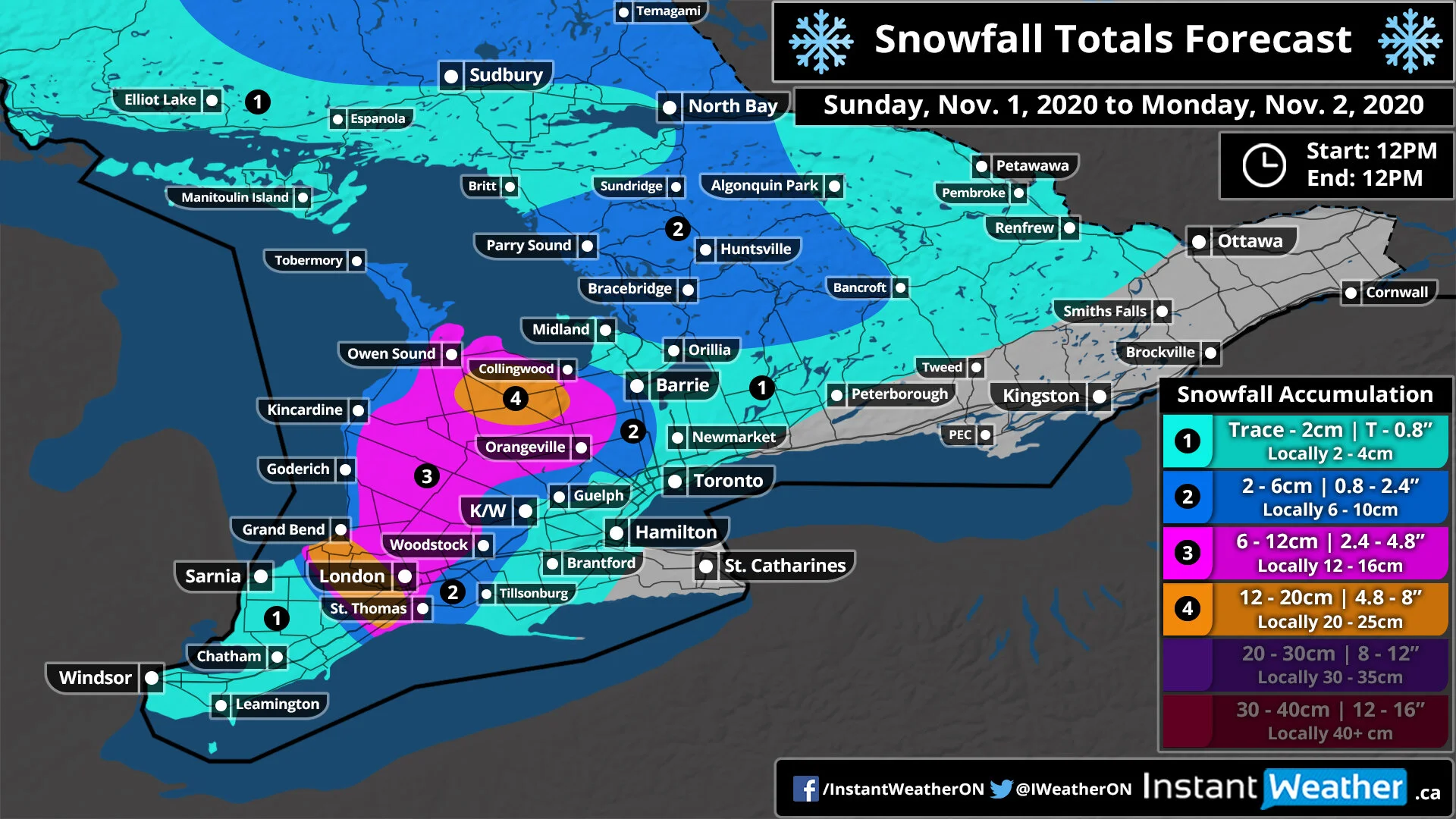
TIP: You can click on the image to open it in a new tab and be able to zoom into the map.
Another messy winter system is expected to affect Southern Ontario starting Tuesday evening and lasting throughout the day on Wednesday. However, the exact impacts will be extremely location dependent with heavy accumulating snowfall possible across Central and Eastern Ontario or a mixed bag of wet snow/rain through Southwestern Ontario and around the Golden Horseshoe. Total accumulation through the hardest-hit areas mainly away from the lakes including locations like Barrie, Muskoka, Peterborough and the Ottawa Valley will generally range from 6-12cm by Wednesday afternoon. A few localized areas may pick up as much as 15cm particularly around the Haliburton, Bancroft and Pembroke area.
As far as timing, we’ve put together a graphic for regions across Southern Ontario showing a rough idea of what to expect. This is only an estimate though and the exact precipitation and timing may vary by a few hours. Download our app HERE and check out the latest up to date hourly forecast for your exact location.

TIP: You can click on the image to open it in a new tab and be able to zoom into the graphic.
Precipitation has already begun to affect Extreme Southwestern Ontario with the Windsor and Sarnia area staying out of the wintery mix with some rain showers ending late this evening and picking back up Wednesday morning. Those along the Lake Huron shoreline like Goderich have already started to see some wet flurries and that will continue for the rest of Tuesday with some heavier snow just before midnight and transition over the rain early Wednesday morning. London and surrounding regions will start with some mixed precipitation this evening and transition over to rain around the midnight hour with a few hours of dryness and picking back up late Wednesday morning. A similar story will unfold across the Golden Horseshoe with wet snow mixed with rain tonight before tapering off early Wednesday morning and returning as rain in the afternoon.
The biggest impact will be through Central Ontario including Barrie, Muskoka and Peterborough with snow starting late tonight and becoming more intense during the overnight. Temperatures are expected to rise just after sunrise on Wednesday so we’ll start to see some rain mixing in during the late morning and transitioning over to rain around noon. For those in Eastern Ontario, you will also get some snow but it will start a few hours later between 1-3 am with heavy snow affecting the morning commute in this area. Rain will start to mix in around Lake Ontario and the St. Lawerence River during the late morning but limited rain is expected to make it into the Ottawa area before precipitation tapers off around in the afternoon.
There will be another round of precipitation through the rest of Wednesday and into the overnight hours but it should be all rain with temperatures across Southern Ontario above the freezing mark. However, this could cause some slushy road conditions with the rain mixing with the previous snowfall.
Accumulation for most areas will range from 6-12cm (likely closer to the lower end of the range) with the potential for around 15cm in localized higher elevations through Central and Eastern Ontario. Lower totals further south including the Northern GTA, K/W and Kingston area with between 2-6cm are expected. Little to no accumulation will be found along the Lake Ontario shoreline into London, Sarnia and Hamilton with some wet snow but likely won’t stick. Windsor will be unaffected by the snow with precipitation coming down as all rain.