White Christmas Locked In for Parts of Southern Ontario, While Others Face the Risk of a Green Christmas for 2025

NOTE: YOU CAN CLICK ON THE MAP TO OPEN A ZOOMABLE IMAGE

As the big day approaches this Thursday, many across Southern Ontario are starting to ask the big question. Will we wake up to that picture-perfect White Christmas, or will the Grinch sneak in at the last minute and snatch it away from right under our noses (and our carrots)?

In some parts of Southern Ontario, especially the snowbelt regions, it might feel like a White Christmas is already wrapped up and sitting under the tree. These areas were absolutely pummelled by relentless snow squalls earlier this month, leaving behind an impressive snowpack.

But for others, it has been a very different story. Some regions managed to dodge the worst of the snow so far this season, and whatever snow did fall has largely melted away thanks to a recent stretch of milder weather.

That sets the stage for a classic Christmas weather showdown. The Grinch, helped along by a few Heat Miser inspired temperature spikes, will try to erase what little snow remains. Jack Frost, however, is waiting in the wings and is expected to take over closer to Christmas. This makes a weak system expected Tuesday into Wednesday the key player, potentially delivering a last minute chance at a White Christmas for some areas.

CURRENT SNOWFALL DEPTH (cm) - MAP FROM WEATHERBELL

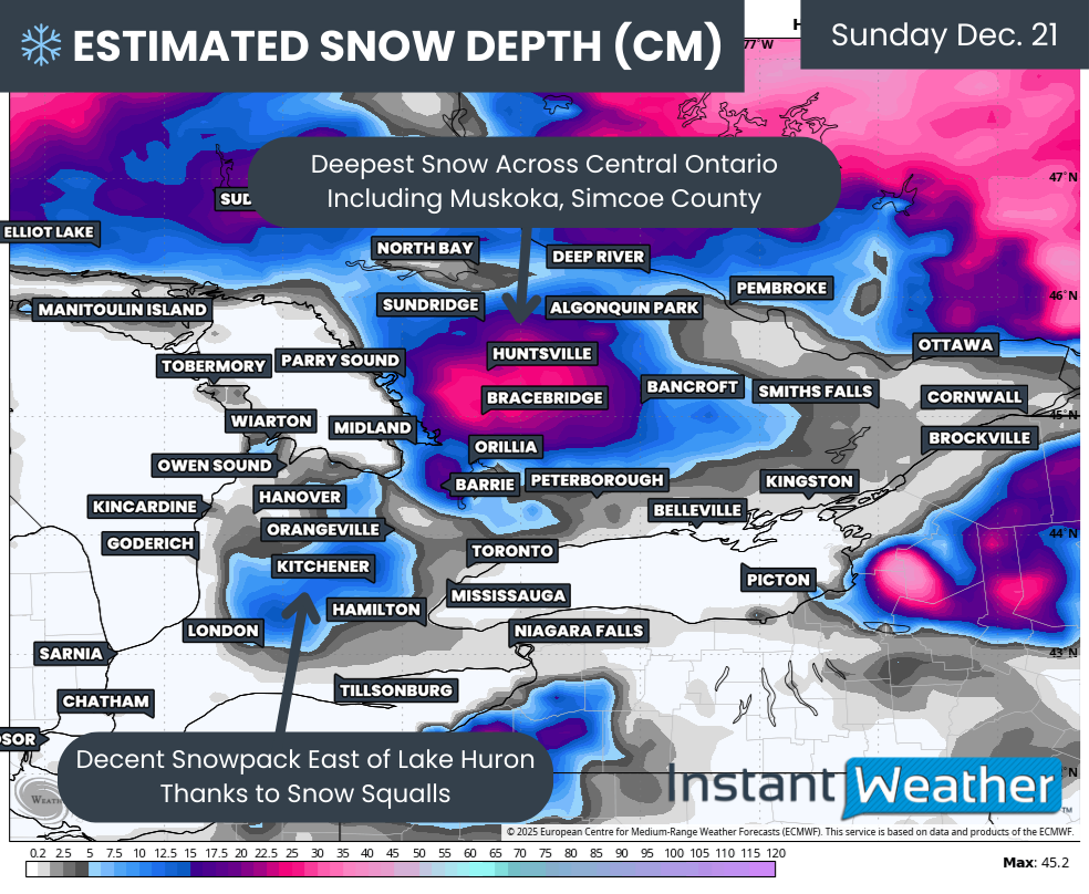
We begin by looking at the existing snowpack, which is often the biggest clue in determining where a White Christmas is all but guaranteed. The most impressive snowpack is found east of Georgian Bay through Simcoe County and into Muskoka, Haliburton and Bancroft.

Model estimates suggest a solid 10 to 25cm of snow on the ground here. These models are fairly low resolution and likely underestimate reality, especially since much of this snow fell during intense lake effect events.

There is also a respectable snowpack of around 5 to 15cm in the higher elevations of Southwestern Ontario, particularly northeast of London. These areas have taken the brunt of snow squall activity several times already this month. Meanwhile, snowpack east of Lake Huron has been noticeably reduced by the recent mild spell.

Outside of those regions, there really is not much snowpack left that can meaningfully contribute to a White Christmas. This includes Deep Southwestern Ontario, the Niagara Region, much of the Golden Horseshoe and into Eastern Ontario, including the Ottawa Valley.

estimated max temp on tuesday - MAP FROM WEATHERBELL

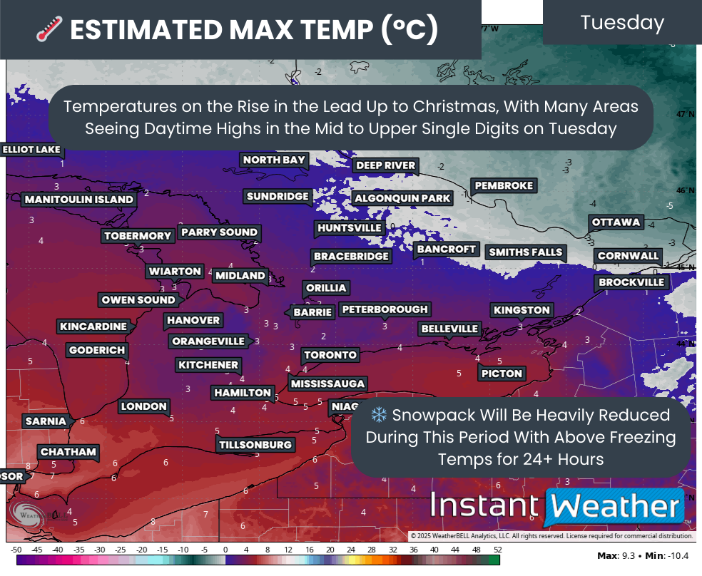
The first challenge arrives early this week as temperatures steadily rise above freezing for more than 24 hours. The warmest day looks to be Tuesday, with daytime highs climbing above freezing across much of Southern Ontario, with the main exception being parts of the Ottawa Valley.

Some areas could even push into the mid to upper single digits, especially in Deep Southwestern Ontario and around the Golden Horseshoe. That is more than enough warmth to put a serious dent in any remaining snow.

Rain may also enter the picture early Tuesday in some areas. Combined with above-freezing temperatures, this will further erode minor snowpack. At that point, the only snow that is truly expected to survive is east of Georgian Bay. For many other areas, including east of Lake Huron, the final outcome will depend heavily on the last 36 hours leading up to Christmas morning.

NEW SNOWFALL BY CHRISTMAS MORNING (cm) - MAP FROM WEATHERBELL

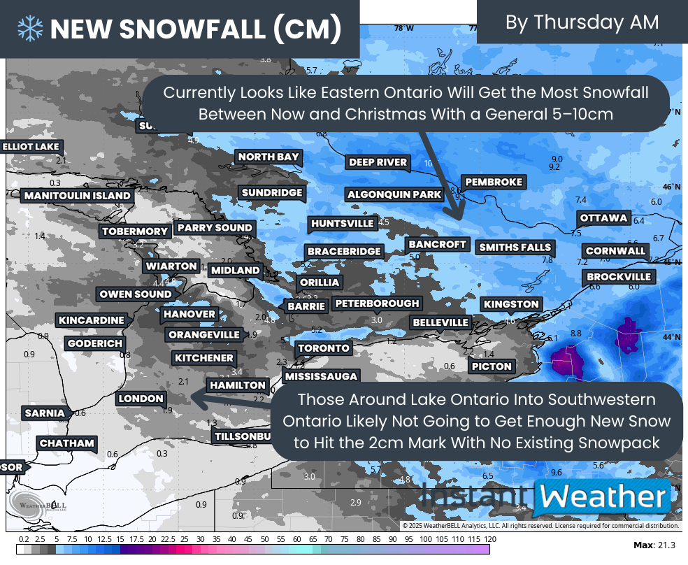
The system moving through on Tuesday is expected to bring light snowfall across Eastern Ontario. With temperatures expected to remain below freezing afterward, this snowfall should help lock in a White Christmas for the Ottawa area, even though there is currently very little snow on the ground. A general 5 to 10cm by Wednesday should be more than enough to tip the scales.

In Southwestern Ontario, however, the outlook is not as festive. Much of the snowfall associated with this system is expected to fall before temperatures rise and precipitation transitions to rain. Any snow that does fall will likely melt away quickly.

The one exception may be the higher elevations east of Lake Huron, where temperatures could hover near freezing just long enough for the snowpack to cling on until Christmas morning. Even there, it will be very close.

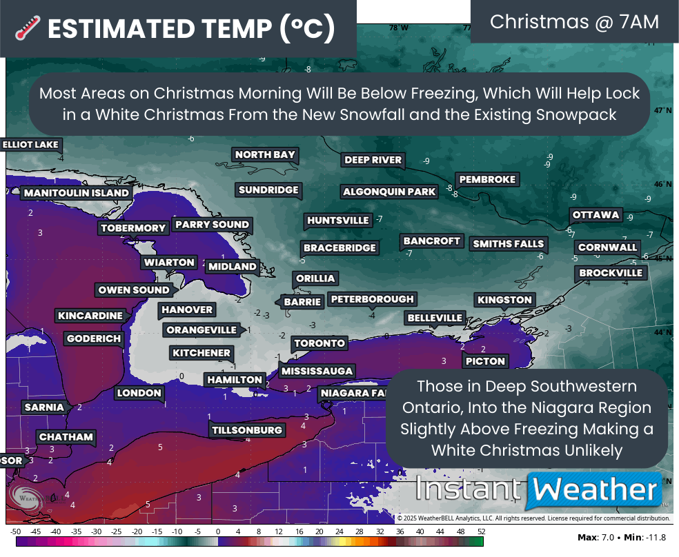
estimated temp on CHRISTMAS MORNING - MAP FROM WEATHERBELL

By Christmas morning itself, current indications suggest many across Southern Ontario will wake up to below freezing temperatures. That will help preserve whatever snow remains on the ground. This includes much of Central and Eastern Ontario, as well as higher elevations northwest of the GTA, such as Orangeville and Kitchener.

In Deep Southwestern Ontario and areas along the Lake Erie shoreline into parts of the GTA, temperatures are expected to be slightly above freezing. With very little existing snowpack to work with, those milder conditions are likely to melt away any lingering hope of a White Christmas.

NOTE: YOU CAN CLICK ON THE MAP TO OPEN A ZOOMABLE IMAGE

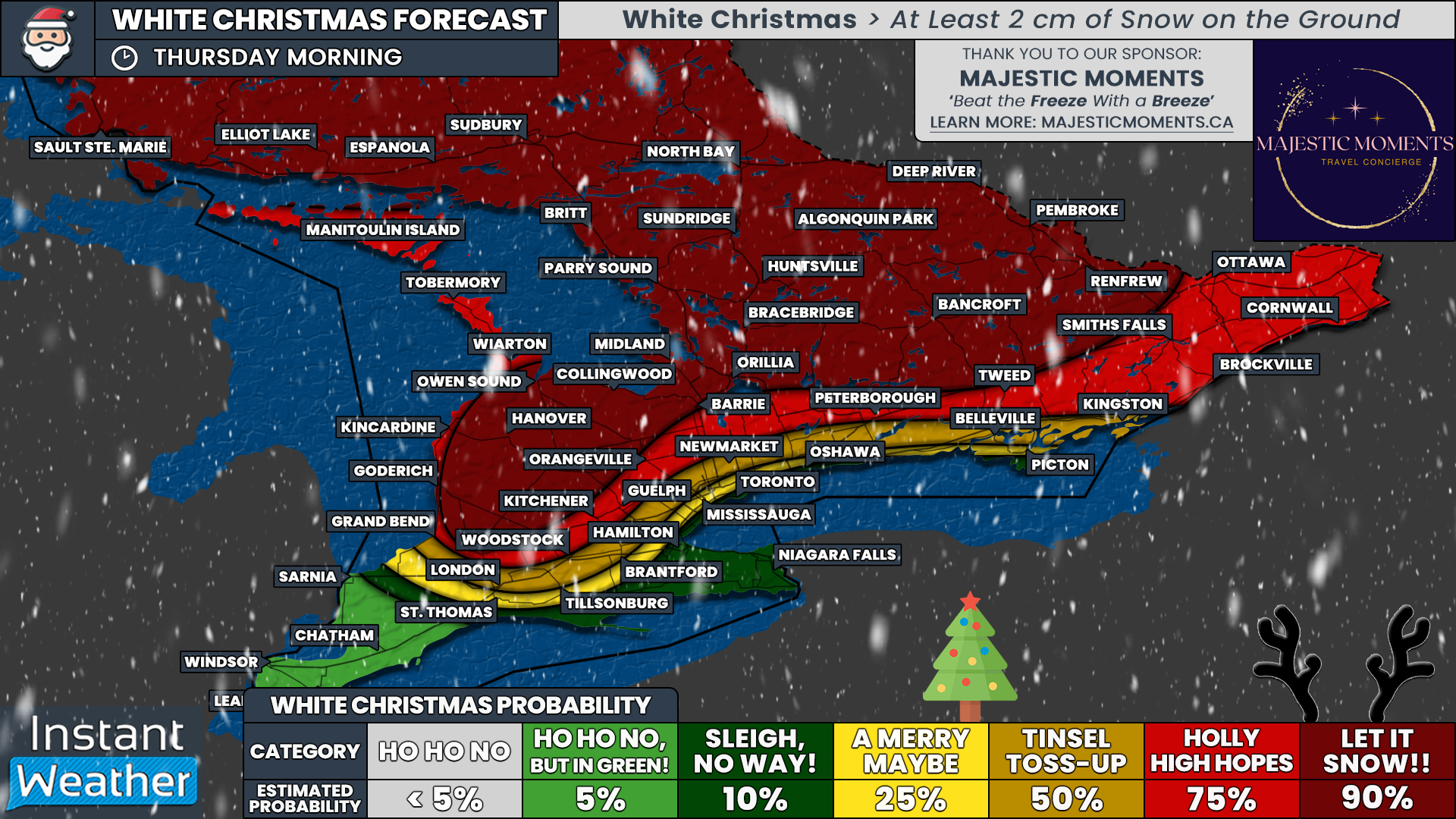
Putting all of this together, we have created our preliminary White Christmas forecast. This is not the final word and adjustments are possible as we get closer to Christmas morning. Several of the uncertainties mentioned above will resolve themselves over the next couple of days, giving us a clearer picture than the models can provide right now.

Our highest confidence area, where we can almost guarantee a White Christmas with a 90 percent chance, covers a wide swath of Central Ontario, including Muskoka, Bancroft and northern and western Simcoe County. These regions have a deep, well-established snowpack. East of Lake Huron, we also assign a 90 percent chance for Hanover and much of Huron and Perth Counties, where repeated lake effect snow has buried the landscape.

Outside of that core region, we currently have a 75 percent chance for much of Eastern Ontario, along with areas such as Peterborough, Barrie and Kitchener. Confidence is fairly strong here, thanks to the existing snow southeast of Georgian Bay and the expected system snowfall in Eastern Ontario on Tuesday.

That said, melting remains a concern for Barrie and Kitchener if temperatures rise a bit more than expected on Tuesday. For Eastern Ontario, confidence also depends on the system delivering as forecast, so we want to see that snow on the ground before bumping probabilities any higher.

Closer to Lake Ontario, the dream of a winter wonderland starts to fade. From Kingston through the north GTA corridor and extending into London, we currently place the odds at around 50 percent. Along the immediate Lake Ontario shoreline, including much of the GTA, things become even more questionable with only about a 25 percent chance of a White Christmas.

For those in the Niagara Region and Deep Southwestern Ontario, including Windsor, Chatham and Sarnia, it may take a true Christmas miracle. Unless a last-minute snowmaker slides through just before Christmas morning, it looks like the Grinch may win this one.

We will continue to monitor the forecast closely and provide updates as Christmas morning draws nearer. Keep checking back, because in the weather, especially at Christmas, surprises are always possible.

A Rare Region-Wide White Christmas Appears to be in Store for the Entire Maritimes This Year

NOTE: YOU CAN CLICK ON THE MAP TO OPEN A ZOOMABLE IMAGE

White Christmases are not a common occurrence for the Maritimes, especially for the entire region, since the late fall is typically mild and rainy. They are so rare in some parts of the region that it has been over a decade since one was last experienced. This year has been fairly average up until very recently and with Christmas now only 3 days away, the odds of a White Christmas across the Maritimes is becoming quite clear.


According to Environment Canada, in order for an area to have a White Christmas, there needs to be at least 2cm of snow on the ground as of 7am on Christmas Day. After Saturdays’s Nor’easter, the snowpack across most of the region is at least 5cm deep. The exception to this is in Guysborough County and into Southern Cape Breton Island, where rain and positive temperatures ended up melting some of the snow that had already fallen from the storm. At this point, it looks like this area just barely reaches the 2cm threshold for a White Christmas.

Looking ahead to the next few days, temperatures reaching only a degree or two above freezing in some areas and the arrival of more snow on Christmas Eve will help solidify the chances for a White Christmas across the Maritimes.

Modelled Snow depths, in centimetres, as of Sunday, December 22nd at 8am aT.


New Brunswick

Temperatures across most of the province are expected to remain below freezing between now and Christmas morning so the snow that is already on the ground is here to stay. A system moving in early Tuesday morning will bring snow to the entire province throughout the day. The heaviest snow is expected to fall in Southern New Brunswick and up to 20cm may accumulate. Although temperatures along the Fundy Coast may creep into the single digits on Tuesday with the arrival of this system, it won’t be enough to melt all of the existing and incoming snow. As a result, all of New Brunswick can expect a White Christmas.

Prince Edward Island

Similar to New Brunswick, temperatures across PEI are expected to remain below 0°C until after Christmas morning. Snow will reach the province before sunrise on Christmas Eve and continue into the evening, adding to the existing snowpack and guaranteeing a White Christmas for the entire Island.

NOTE: YOU CAN CLICK ON THE MAP TO OPEN A ZOOMABLE IMAGE


Nova Scotia

The chances for a White Christmas vary slightly across Nova Scotia. Given the shallow depth of the snowpack in parts of Eastern Nova Scotia, chances are high, but not a guarantee and just a little bit of melting could spoil things. Luckily as of now, it appears that any melting might not happen in this area until the afternoon on Christmas Day when temperature rise above the freezing mark.

Snow is expected to move into Western Nova Scotia early Tuesday morning and will cross the province through the remainder of them morning. Although it is expected to be light and fairly brief, the additional snow will be welcome news for those in Eastern Nova Scotia who are hoping for that traditional White Christmas. This extra snowfall keeps the odds of a White Christmas high in the areas of shallow snowpack, barring any major melting that might occur a little ahead of schedule.

The snow will be heavy at times across parts of Western Nova Scotia, leading to over 10cm of accumulation. Temperatures in this area are anticipated to climb into the single digits, particularly along the shorelines, so it’s possible that there will be a transition over to rain, but this isn’t expected to be enough to ruin the chances of a White Christmas. Some weather models are even suggesting that the snow could continue to fall in Western Nova Scotia into Christmas morning, leading to what some consider to be a “true” White Christmas!


Please keep in mind that this is just a preliminary forecast, along with the first look at the incoming snowfall, and this is based on current data. The full forecast for the incoming snow will be posted Monday afternoon/evening and the final White Christmas forecast is coming Christmas Eve morning. Make sure to stay tuned!

A White Christmas is in the Forecast for Most of the Prairies, Odds are Not Good in Southern Alberta

NOTE: YOU CAN CLICK ON THE MAP TO OPEN A ZOOMABLE IMAGE

The second half of November and all through December have been marked by a series of snowstorms and periods of frigid temperatures across the Prairies. With Christmas only four days away, the odds of a White Christmas are becoming clearer.


According to Environment Canada, in order for an area to have a White Christmas, there needs to be at least 2cm of snow on the ground as of 7am on Christmas Day. This is typically an easy threshold to cross in the Prairies and it appears that this year will be no different for most, but not all.

Currently, the snowpack is considerable across the Prairies, at least 10cm deep across a majority of the regions and large swatch where the snow is over 20cm in all three provinces. There are a few pockets where this is the exception, particularly in Southern Alberta where warm temperatures early in the week have resulting in little to no snow on the ground. Looking ahead over the next few days, some warmer air and a mix of rain and freezing rain will decrease the likelihood of a White Christmas for some.


Modelled Snow depths as of Saturday, December 21st at 6am CT.

Manitoba

Northern Manitoba may see some scattered flurries this evening and overnight and again Tuesday morning. Otherwise, there is no other fresh snow expected between now and Wednesday morning. Temperatures will remain below freezing across the province until Christmas morning so no melting of the existing snow is expected. As a result, all of Manitoba can expect a White Christmas.

Saskatchewan

Like Manitoba, Northern Saskatchewan may see scattered flurries over the next few days, but no significant snowfall is expected. There is, however, a threat to White Christmas chances in Southwest Saskatchewan.

Early Sunday morning, temperatures in this area will climb to above freezing and will stay there throughout most of the day. Not only will this melt some of the limited snowpack in the area, a mix of rain and freezing rain will also result in melting. Temperatures are expected to rise once again on both Monday and Tuesday. With no additional snow in the forecast, a White Christmas can not be guaranteed in this area, but it is not completely ruled out.


Alberta

The chances for a White Christmas will vary across Alberta. A large part of Southern Alberta already has less than 5cm of snow on the ground and daily highs in the single digits between now and Christmas significantly impact the chances of a White Christmas here. The relative warmth will also stretch northward, just east of the Rockies over the coming days, but the greater snowpack and temperatures only reaching a degree or two above freezing will keep the hopes for a White Christmas alive.

The only fresh snow in the forecast for the province will be isolated to the Mountains and far Northern Alberta. There’s the chance for some rain to cross through Southern Alberta overnight and through Sunday morning which will further hinder the likelihood of a White Christmas in the area.


Please keep in mind that this is just a preliminary forecast and is based on current data. The forecast will be updated over the coming days, with the final forecast set to be posted on Christmas Eve. Make sure to stay tuned!

It’s a Christmas Miracle! A White Christmas Is Likely for Most of Ontario & Quebec This Year

NOTE: YOU CAN CLICK ON THE MAP TO OPEN A ZOOMABLE IMAGE

The month of December has truly delivered a winter wonderland for much of Ontario and Quebec, especially in the snowbelt regions of Ontario, which have seen significant snowfall from several rounds of snow squalls in recent weeks.

With Christmas just around the corner—less than five days away—the question on everyone’s mind is whether we’ll wake up to a White Christmas or a Green Christmas this year.


For clarity, Environment Canada defines a "White Christmas" as having at least 2 cm of snow on the ground at 7 a.m. Christmas morning. Unfortunately, in recent years, Southern Ontario’s holiday season has often been marked by the Grinch’s meddling, with last year seeing widespread "Grinchmas" conditions.

Currently, the snowpack across much of the region is quite substantial, particularly east of Georgian Bay, into Northern Ontario, and across Quebec. The good news for these areas is that the forecast suggests little to no rain or mild temperatures between now and Christmas, making a White Christmas virtually guaranteed.


However, the story is quite different for southern portions of the region, including Deep Southwestern Ontario and the Golden Horseshoe. These areas haven’t seen much in the way of significant snowfall accumulation this month, and the forecast includes a stretch of above-freezing temperatures on Christmas Eve and Christmas Day.

As a result, the odds of a White Christmas here depend entirely on whether snow can accumulate between now and Christmas morning.

Thankfully, hope isn’t entirely lost! A developing system is expected to move into Southern Ontario early Monday, continuing into Christmas Eve on Tuesday. Recent model updates have been promising for snow lovers, trending toward a stronger system that brings more widespread snowfall.


NOTE: YOU CAN CLICK ON THE MAP TO OPEN A ZOOMABLE IMAGE

Current projections suggest this system could deliver 10–20 cm of snow across Central and Eastern Ontario. However, for those along the Lake Ontario and Lake Erie shorelines, including parts of the GTA and Niagara Region, snowfall amounts may be significantly lower due to temperatures rising above freezing during the day on Monday. This could lead to melting or even a mix with rain, reducing accumulation to just a few centimeters.

With temperatures hovering slightly above freezing through Christmas Eve, it’s uncertain whether any snow from this system will survive until Christmas morning in these areas.


WHITE CHRISTMAS REGIONAL BREAKDOWN

Central Ontario, including Muskoka, Tobermory, Bancroft, and Algonquin Park, has the best odds in Southern Ontario. These areas already boast a healthy snowpack from earlier systems and lake-effect snow, and Monday’s storm will only add to it. Temperatures are expected to remain below freezing, ensuring the snow sticks around. The chance of a White Christmas here is over 90%.

Eastern Ontario and areas near Lake Huron, including the Ottawa Valley and regions around Lake Simcoe, have a slightly lower chance at 75%. Eastern Ontario currently has little snow on the ground, but Monday’s system is expected to change that. Lake Huron’s shoreline, while already snow-covered, will face a brief warm-up Monday into Christmas Eve. While the snow is likely to hold, it isn’t guaranteed.


For areas like Sarnia, London, Kitchener, Guelph, and Belleville, the chance of a White Christmas is more uncertain at 50%. Everything depends on how much snow Monday’s system delivers and whether it can survive the milder temperatures leading into Christmas morning.

In the GTA, including Hamilton and northern parts of Niagara, the odds of a White Christmas are slim with a 25% chance. Without an existing snowpack and with limited accumulation expected from Monday’s storm, above-freezing temperatures are likely to melt any snow that does fall. However, if the storm overperforms or the warm-up is less intense, we could see a last-minute boost in probabilities.


Deep Southwestern Ontario, including Windsor and areas along the Lake Erie shoreline, is the least likely to see a White Christmas, with just a 10% chance. Monday’s system is forecast to bring minimal snow, and the prolonged warm-up will likely ensure a Green Christmas here.


NOTE: YOU CAN CLICK ON THE MAP TO OPEN A ZOOMABLE IMAGE

Northern Ontario offers little drama in this forecast. With widespread snow on the ground and no significant warm-up in sight, the region enjoys a 90%+ chance of a White Christmas across the board.

Much of Quebec also looks set for a picturesque holiday. The exception is the Montreal area, which currently has limited snow on the ground. However, like Eastern Ontario, this should change once Monday’s system moves through.


This forecast remains preliminary and will be updated as we approach Christmas. Our final White Christmas forecast, set to be released on Christmas Eve, will factor in Monday’s storm and provide a clearer picture. If the snow cooperates, expect to see more 90%+ zones on the map. Stay tuned, and let’s hope for a festive, snow-covered holiday!