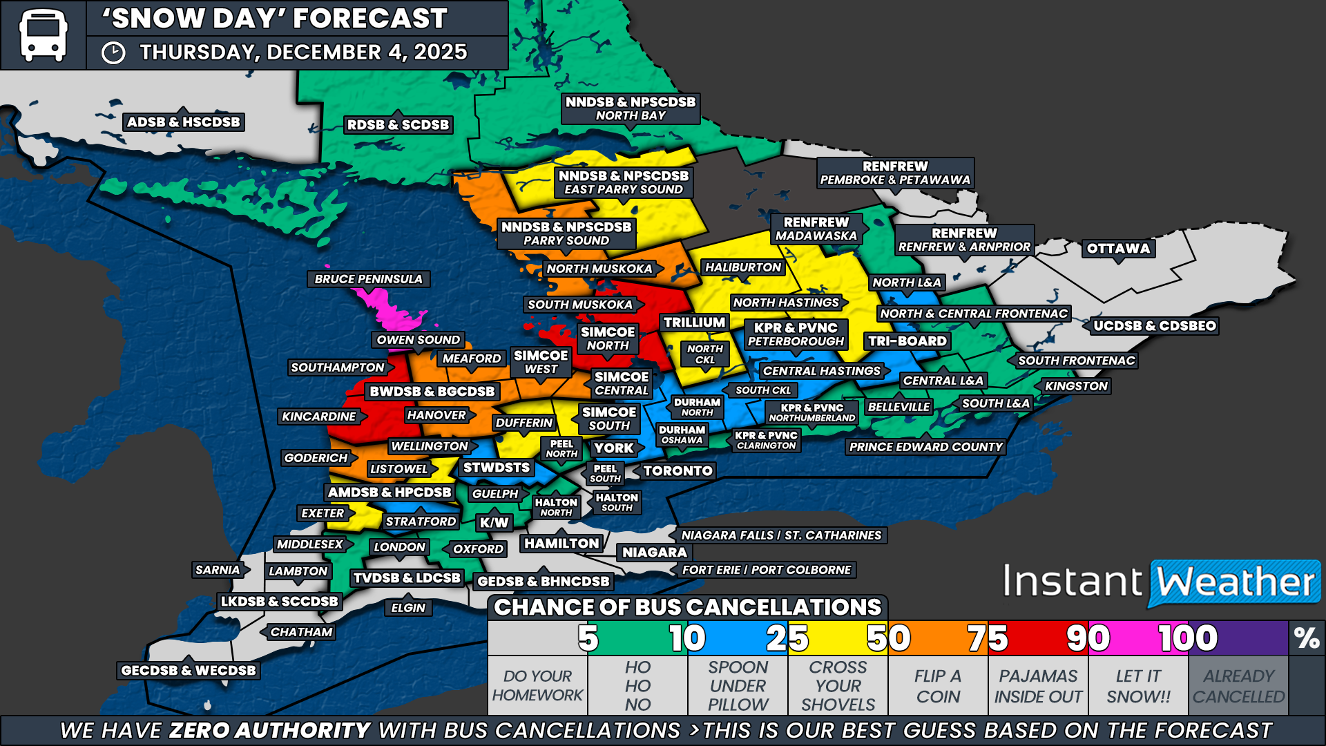
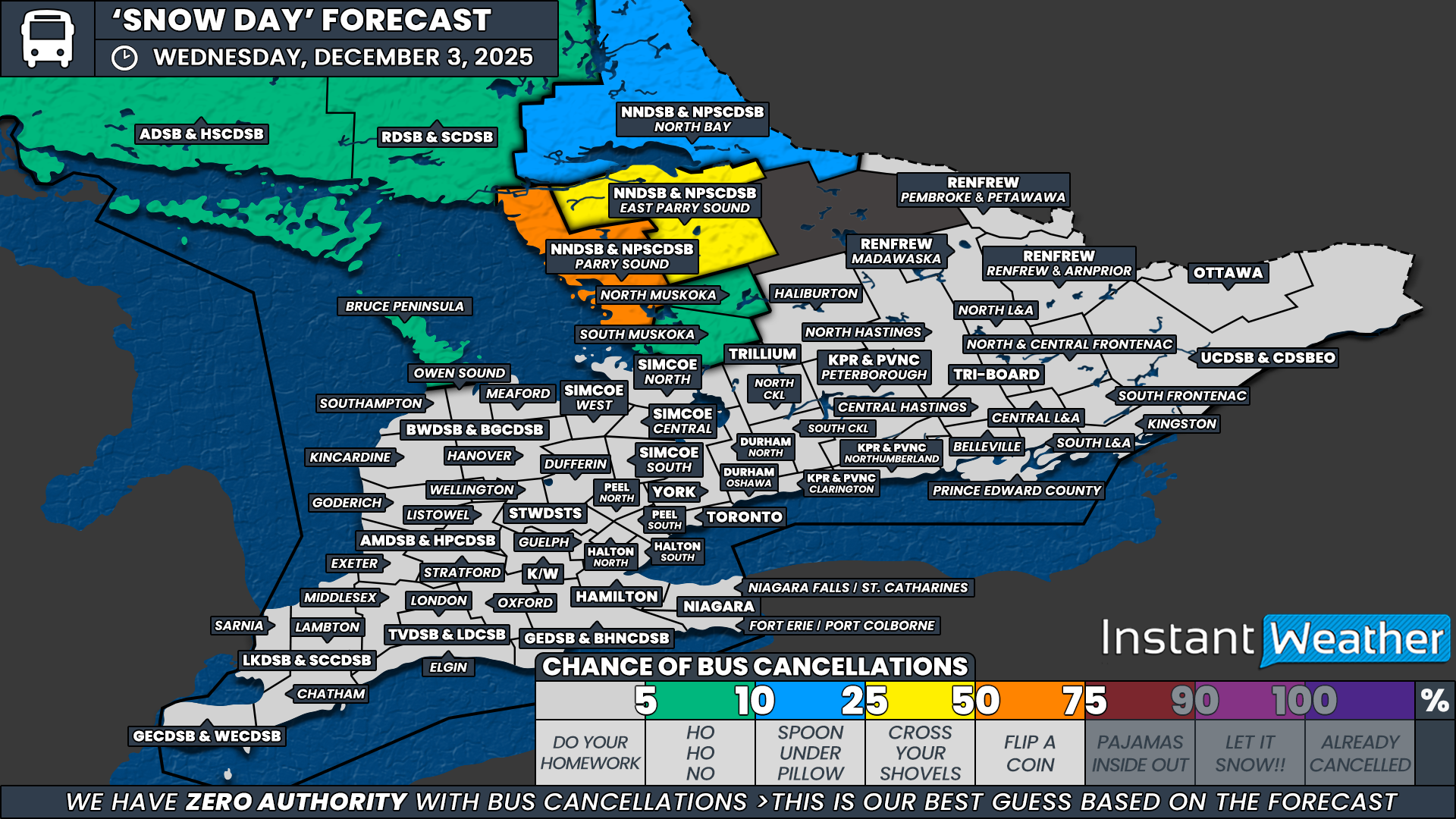
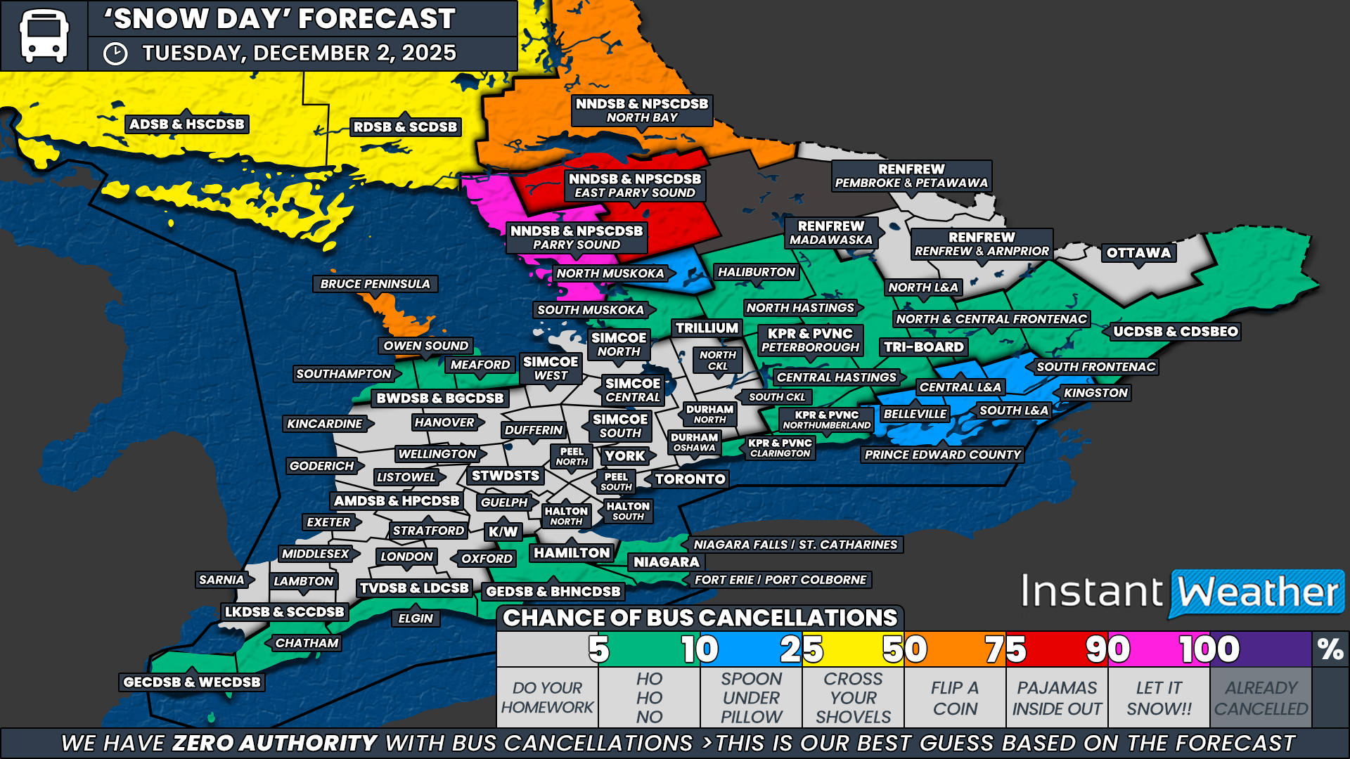
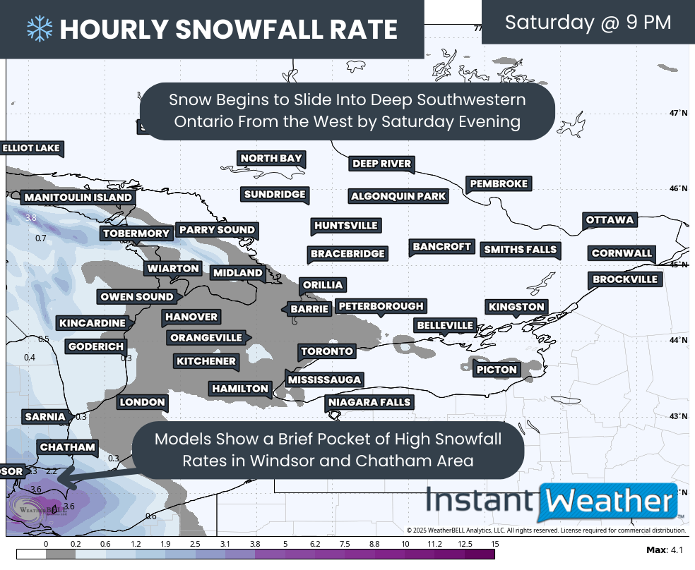
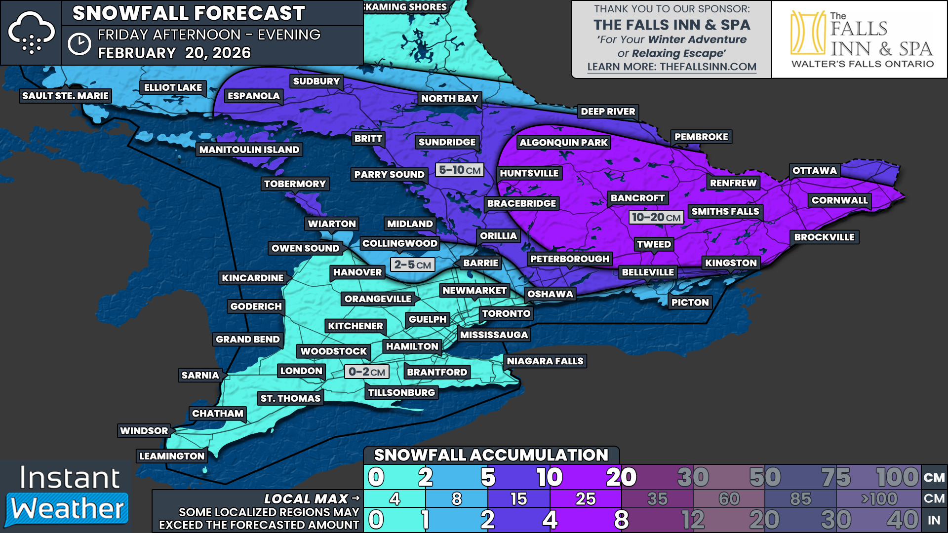
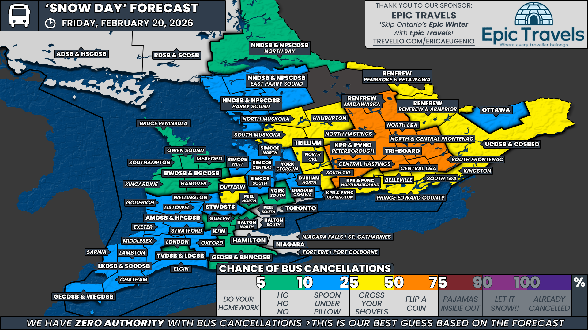
Nasty Winter Storm Will Bring Mixed Bag of Precipitation, Flash Freeze Risk, and Strong Winds to Alberta Monday & Tuesday

NOTE: if you click or tap on this image you can zoom it

The forecast across Alberta for Monday and Tuesday is certainly complex. We are looking at all precipitation types; rain, snow, freezing rain and ice pellets; to be falling somewhere in the province and some places could see a combination of different kinds of precipitation. There is also a widespread risk of a flash freeze and to top it all off, wind gusts exceeding 100km/h are likely.

Before we get too ahead of ourselves, let’s start with the least complicated aspect of the forecast: the snow in Northern Alberta and through the Rockies.

Northern Alberta & The Rockies

Light snow has been falling in parts of Northern Alberta Monday morning and into the afternoon, trailing the previous round of widespread snowfall across the region. A narrow band of snow will persist through the afternoon and drop 5+cm of accumulating snow by the evening.

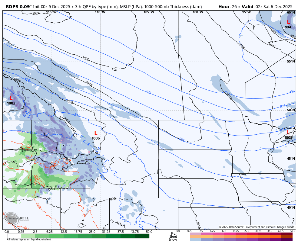
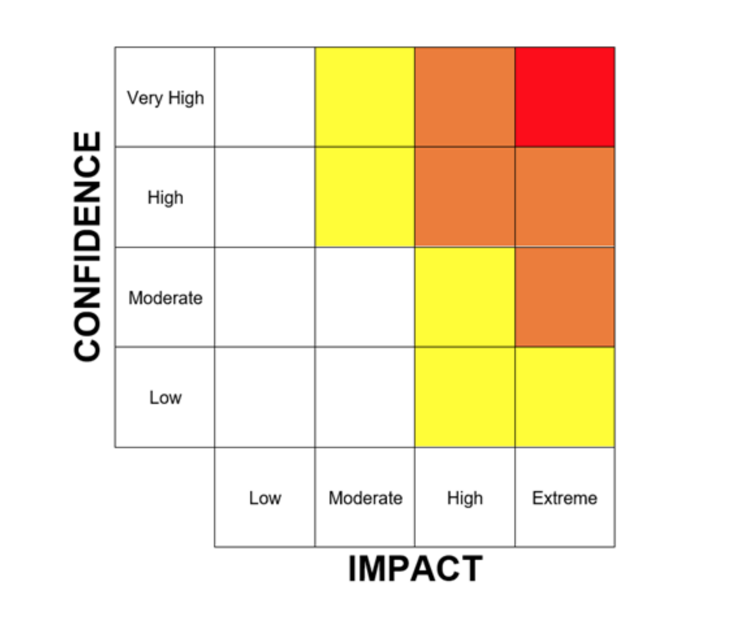
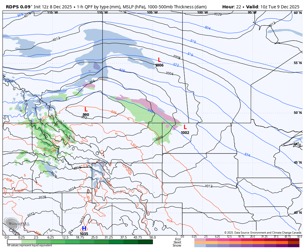
The Hrdps model showing precipitation type and intensity at 5Pm MT on Monday, courtesy of WeatherBell.

In the evening, widespread snow will move into Northern Alberta, including the Northern Rockies, from British Columbia. The snow will spread southeastward across Northern Alberta and into parts of Central Alberta during the evening and overnight hours.

The snowfall will last for up to 8 hours and it will start to taper off along the BC border shortly after midnight. This large band of snow will exit into Saskatchewan before sunrise, but scattered areas of light snow will linger through the morning across Northern Alberta.

The area that is expected to see snow throughout Monday afternoon will end up with the greatest accumulation by Tuesday afternoon. More than 15cm of fresh snow is anticipated over this area, especially in Peace River, on top of what has already fallen from the weekend. Beyond this, the rest of Northern Alberta and into parts of Central Alberta will be in the 5-15cm range and accumulations decrease moving southward. There is a slight caveat to this, which we will touch upon a bit further down.

NOTE: if you click or tap on this image you can zoom it

For the Rockies, the snowfall will spread southward during the evening and overnight. Overall, 5-15cm can be expected throughout this region. The higher elevations will approach 15cm while the valleys will be closer, or possibly even below, 5cm.

Central Alberta

Things start to get messy in parts of Central Alberta as the band of snow travels southeastward into the region.

The arrival of a warm front that crossed through Central and Southern Alberta overnight Sunday has resulted in temperatures climbing to a few degrees above the freezing mark across the region. As the snow from Northern Alberta tracks southeast through the evening and overnight Monday, and encounters this warmer air above the surface, there will be a transition over to ice pellets (sleet) and freezing rain.

This is expected to start to occur to the north of Edmonton, from Whitecourt to St. Paul. Despite the surface temperatures remaining subzero in this area, there will be enough warm air aloft for the transition to ice pellets to happen and this area could see a few centimetres of ice pellets accumulating. The caveat mentioned above is that the map of snowfall totals also includes accumulation of ice pellets in this area.

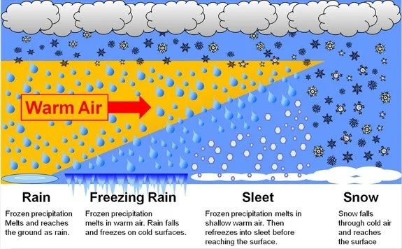
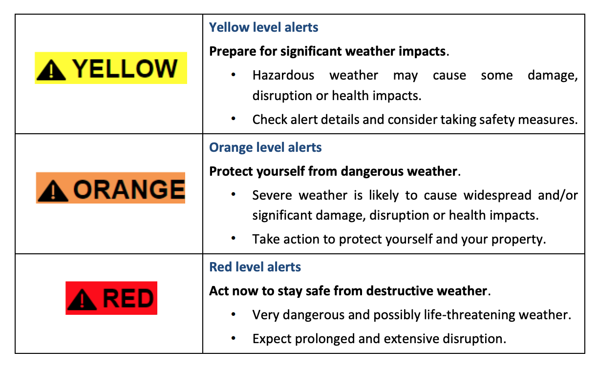
precipitation types and their corresponding temperature profiles

Moving southward, the amount of warm air aloft increases and the precipitation will change to freezing rain. The area at risk of freezing rain stretches roughly from west of Drayton Valley and Rocky Mountain House to Wainwright and Provost. The northern part of this area will likely see a combination of ice pellets and freezing rain as the thickness of the warm air aloft decreases.

The freezing rain is expected to be light and only last for an hour or two, resulting in up to 1mm of ice accretion. However, this is still enough to cause some issues when travelling on untreated roads.

Timing-wise, the ice pellets and freezing rain will start to fall as early as 7pm Monday evening and continue into the overnight hours as the band of precipitation tracks towards Saskatchewan.

The rdps model showing precipitation type and intensity at 3am MT on Tuesday, courtesy of WeatherBell.

Southern Alberta

In Southern Alberta, as well as in portions of Central Alberta, surface temperatures hovering around zero, and slightly above, will lead to precipitation falling as rain with a bit of wet snow mixed in. The rain will be light and scattered, broken off from the main band of precipitation, throughout the region overnight and into Tuesday morning. Unfortunately, this poses a unique problem for this region.

In the early morning hours of Tuesday, a sharp cold front will start to blast southward through Central and Southern Alberta. Temperatures could plunge by up to 20°C in the span of only a few hours, resulting in a flash freeze of any rain that has fallen, as well as the snow melt from the previous day.

This flash freeze is expected to happen just in time for the morning commute for Calgary and communities to the north, so road conditions could be very poor if they aren’t treated ahead of time and maintained. The cold front will then stall around Calgary through the morning and afternoon before it continues tracking southward during the evening, bringing below freezing temperatures to the rest of Southern Alberta.

If that wasn’t enough, strong winds gusts up to, and possibly exceeding, 100km/h are possible in Southwestern Alberta overnight Monday. Luckily, these strong winds should die down by Tuesday morning.

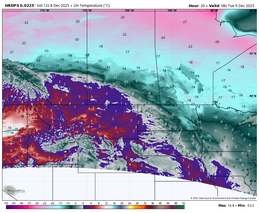
The hrdps model showing surface temperature at 1am MT on Tuesday, courtesy of WeatherBell.

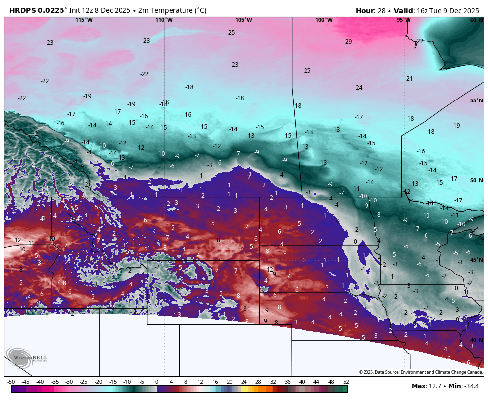
The hrdps model showing surface temperature at 0am MT on Tuesday, courtesy of WeatherBell.

All in all, this incoming system will impact most of Alberta, with each region expecting to be impacted in different ways. Road conditions will deteriorate across the province at some point over the next 24 hours so make sure to plan accordingly when travelling and stay safe.

Southern Ontario: ‘Snow Day’ Forecast for Monday, December 8, 2025

NOTE: YOU CAN CLICK ON THE MAP TO OPEN A ZOOMABLE IMAGE

With no major winter weather expected across Southern Ontario on Monday, we are not anticipating any widespread school bus cancellations.

There is, however, a low to slight chance (10 to 25 percent) for parts of Central Ontario, including regions under the Near North District School Board, as well as Muskoka and Haliburton within the Trillium Lakelands District School Board, and North Hastings under Tri-Board Student Transportation Services.

This is tied to the small possibility of cold-related cancellations. While current forecasts do not show temperatures dropping to levels that typically prompt a cancellation, if conditions trend colder overnight, a surprise decision cannot be ruled out.

We have also assigned a low to very low chance for areas near Lake Huron and Georgian Bay, where lake effect snow is still ongoing. Accumulation should taper off through the next few hours, and with totals expected to remain manageable, the likelihood of cancellations here is quite limited.

Everywhere else, we do not expect any disruptions to bus service on Monday. So tonight’s forecast is looking like you should plan to do your homework.


Disclaimer: Instant Weather has zero authority when it comes to bus and school closures.

It is completely up to the school boards, bus companies, local authorities, and parents to decide what is best for their children. This is our best guess based on our forecast.

Southern Ontario: School Bus Cancellations and Closures for Friday, December 5, 2025

**Please refresh your page every few minutes to receive the latest update**

Cancellation & Closure Map (English Public and Catholic Schools)

Please note: School board boundaries are a rough estimate. Don’t use this map to determine what school board or weather zone you live in as accuracy isn’t guaranteed.

  • Green = No Cancellations

  • Red = Cancellations (Click for More Details)

  • Purple = School Closures (Click for More Details)

List of Cancellations & Closures

English Public and Catholic Schools

  • Near North Public & Nipissing-Parry Sound CathoIic: Bussing for all weather corridors are cancelled today.

French Schools

  • Le Conseil scolaire public du Nord-Est de l’Ontario (CSPNE) & Conseil scolaire catholique Franco-Nord: Bussing for all weather corridors are cancelled today.

Short Blast of Snow Behind a Cold Front Will End the Week with 5-15cm of Snow for Parts of Alberta

NOTE: if you click or tap on this image you can zoom it

After some above-freezing temperatures and a mixed bag of precipitation on Thursday, a cold front will sweep through Central and Southern Alberta overnight Thursday. The arrival of cooler air will be accompanied by widespread snow on Friday. Accumulations of 5-10cm are expected across a swath of Northern and Central Alberta, as well as parts of Southern Alberta, by the end of the day Saturday.

Scattered flurries are likely Friday morning and into the early afternoon, but the snow will become more organized in the mid-afternoon. It will begin in the Grande Prairie area and then spread southeast during the late afternoon and evening. Accumulating snow will arrive in Edmonton just in time for the evening commute so the drive home may be slow.

In the late afternoon, snow will also cross into Southern Alberta from the Rockies and spread eastward through the evening. While snow is also expected to impact Calgary during the evening commute, the snow will be lighter and shouldn’t cause too many problems for drivers.

The rdps model showing precipitation type and intensity at 7Pm MT on Friday, courtesy of WeatherBell.

Steady snowfall is expected to continue across a large stretch of the province into the overnight hours, but it will start to taper off in the early morning. By sunrise on Saturday, most of the snow will have ended, but there will still be some lingering light snow throughout the remainder of the day.

Overall, 5-15cm of snow can be expected from Grande Prairie through Edmonton and towards the Saskatchewan border. Most of this area will be in the 5-10cm range, but snowfall totals could approach 15cm around the Grande Prairie and High Prairie.

In Southern Alberta, some localized intensification is possible Friday evening and overnight around Lethbridge and Taber, which would lead to accumulation exceeding 5cm. Otherwise, the remainder of Central and Southern Alberta and into Northern Alberta will see 2-5cm of snow, but there is the possibility of snowfall totals exceeding 5cm locally.

Winds should remain fairly light while the snow is falling so blowing snow shouldn’t be too much of a concern.

Southern Ontario: ‘Snow Day’ Forecast for Friday, December 5, 2025

For an updated list of school bus cancellations & school closures, please visit our live article: https://instantweatherinc.com/article/2025/12/5/bus-cancellations

NOTE: YOU CAN CLICK ON THE MAP TO OPEN A ZOOMABLE IMAGE

Regions northeast of Georgian Bay are expected to see another round of snow squalls developing Friday morning and continuing throughout the day. These bands may intensify at times, creating reduced visibility and rapid snowfall accumulation.

Environment Canada has issued a snow squall watch for the area, noting the potential for 20 to 40 cm of snow. Given that setup, there is a reasonable chance that the Near North District School Board will choose to cancel buses in the hardest hit regions.

The highest likelihood is in the Parry Sound zone, which sits closest to where the squalls are expected to come ashore. We have assigned this area a 75 percent chance of cancellations. The remainder of Near North, including East Parry Sound and North Bay, is sitting at 50 percent as it is still unclear how far inland the strongest bands will extend.

We have also included a 25 percent chance for the Rainbow District School Board, focused mainly on Manitoulin Island, where the snow squall watch is also in effect. It is unlikely that the board would cancel across the entire district, so those in Greater Sudbury should expect buses to run as usual.

Elsewhere across Southern Ontario, no significant weather impacts are expected. This leaves the chances of a snow day in the low to very low range for most regions, so it may be a good idea to plan on doing your homework.


Disclaimer: Instant Weather has zero authority when it comes to bus and school closures.

It is completely up to the school boards, bus companies, local authorities, and parents to decide what is best for their children. This is our best guess based on our forecast.

Southern Ontario: School Bus Cancellations and Closures for Thursday, December 4, 2025

**Please refresh your page every few minutes to receive the latest update**

Cancellation & Closure Map (English Public and Catholic Schools)

Please note: School board boundaries are a rough estimate. Don’t use this map to determine what school board or weather zone you live in as accuracy isn’t guaranteed.

  • Green = No Cancellations

  • Red = Cancellations (Click for More Details)

  • Purple = School Closures (Click for More Details)

List of Cancellations & Closures

English Public and Catholic Schools

  • Avon MaitIand Public & Huron-Perth CathoIic: There are several cancellations/closures, please visit this link for more details: https://hpsts.mybusplanner.ca/Alerts

  • BIuewater Public & Bruce-Grey Catholic: All busses are cancelled.

  • Lambton Kent Public & St. CIair Catholic: Buses in Zone 7 Cancelled Due to Road Conditions

  • Simcoe County Public & Simcoe Catholic: Busses are cancelled for the North Zone.

French Schools

  • Conseil scolaire catholique Providence: Busses are cancelled for Simcoe Zone North, Middlesex Region of Huron Perth, Chatham-Kent Zone 7, and Bruce-Grey Region.

  • Conseil scolaire Viamonde: Busses are cancelled for Simcoe Zone North, Middlesex Region of Huron Perth, Chatham-Kent Zone 7, and Bruce-Grey Region.

Brief, Intense Snow Squalls Return to Southern Ontario’s Snowbelt on Thursday With Up to 20 to 50cm Expected

NOTE: YOU CAN CLICK ON THE MAP TO OPEN A ZOOMABLE IMAGE

Intense but brief snow squalls are expected to return to parts of the snowbelt region around Lake Huron and Georgian Bay early Thursday morning with the arrival of a blast of brisk Arctic air. These squalls have the potential to bring heavy snowfall and near-zero visibility in the hardest hit areas.

Conditions are certainly ripe for more extreme, long-lasting squalls; However, the latest model data suggests this round will be cut short as shifting winds prevent the bands from locking in place for any prolonged period of time.

Snow squalls developing off Lake Huron will follow a west-northwest flow with the most intense activity aimed at the northeastern shoreline, which includes much of Grey Bruce. Another band off Georgian Bay will have a less steady flow, making the Lake Huron squall the stronger and more focused of the two.

This band is expected to remain mostly stationary through much of the morning and possibly into the early afternoon before slowly weakening later in the day. Hazardous conditions are expected in this zone with complete whiteouts, blowing snow and rapid snowfall rates of 4 to 6cm per hour.

The hardest hit areas are likely to be around Port Elgin, Kincardine and Owen Sound where a band could set up early and barely move until the afternoon as winds ease and the squall dissipates. The reach of this band may stretch inland into parts of Grey County at times, including Meaford, Chatsworth, Flesherton and Hanover. Some areas could be digging out from significant totals by the end of the day.

Meanwhile, over Georgian Bay, shifting wind directions will make things much less predictable. The squall here will likely spread snowfall over a wider area rather than focusing on one region, mainly due to the flow swinging from westerly to northwesterly throughout the day.

It will likely begin with a westerly flow during the early morning, which would start the band in southern Muskoka, including MacTier, Bala, Bracebridge and Gravenhurst. It may also extend at times into southern Haliburton and northern Kawartha Lakes.

As winds turn more northwesterly, the band will slide down along the Hwy 400 and 11 corridor into northern Simcoe County, affecting Midland, Orillia and Washago. Travel in this region during the morning and early afternoon should be avoided if possible, as conditions will be quite poor.

There is still some uncertainty regarding the intensity of this Georgian Bay band, as shifting winds tend to weaken squalls and make them less organized. If it becomes even briefly stationary, that would likely be the period where snowfall intensifies.

How long the band can hold together before winds lock into a true northwest flow will determine totals for areas such as Barrie and the southern portions of Kawartha Lakes. By the early afternoon, the squall will have sunk into Wasaga, Oro and Barrie, but once the wind shift finalizes, the band will quickly lose its structure and begin to fizzle out.

If the squall lasts only into the mid-afternoon, Barrie may end up closer to 10cm. If it somehow holds into the evening, totals closer to 30cm would be possible.

All snow squall activity is expected to taper off by Thursday evening across Southern Ontario, although some light snow may linger overnight into Friday morning in areas closer to the lakes.

For Northern Ontario, snow squalls off the southeastern shoreline of Lake Superior will develop overnight and persist through much of Thursday. Sault Ste. Marie and the Wawa region may pick up 30 to 50cm by the end of the day. That lake effect activity is expected to weaken Thursday evening as a weak system shifts the wind direction.

Snowfall totals will vary widely due to ongoing uncertainty about the exact placement and duration of the bands. Confidence is highest that the Lake Huron squall will remain more focused compared to the Georgian Bay band.

As a result, the hotspot includes Port Elgin, Owen Sound, Hanover and Chatsworth, where 30 to 50cm is expected, with some models even hinting at localized pockets approaching 60cm.

The rest of Grey and Bruce counties are looking at 15 to 30cm, although totals may vary significantly depending on how far inland the squall extends and whether it drifts south into northern Huron and Perth counties.

Areas farther south and inland, including the rest of Huron and Perth counties, Wellington, Dufferin and Collingwood can expect around 5 to 15cm, but there is still a chance for much lower amounts if the band does not stretch that far.

A large zone along the Hwy 400 and 11 corridor from MacTier and Gravenhurst in the north to Barrie in the south, including Midland, Washago, Orillia and Wasaga, is expected to see the highest totals from the Georgian Bay squall.

At this point, 15 to 30cm appears likely, although localized totals up to 40cm are possible should the squall stall for any period of time. If that occurs, the most probable region for this is somewhere between Midland and Orillia.

The rest of Muskoka, Parry Sound, Haliburton, Kawartha Lakes and northern York and Durham regions can expect between 5 and 15cm, depending heavily on how far inland the Georgian Bay squall is able to stretch.

Elsewhere across Southern Ontario, less than 5cm is expected by the end of Thursday.

‘Snow Day’ Forecast: Snow Squalls Threaten Widespread School Bus Cancellations in Southern Ontario’s Snowbelt on Thursday

For an updated list of school bus cancellations & school closures, please visit our live article: https://instantweatherinc.com/article/2025/12/4/bus-cancellations

NOTE: YOU CAN CLICK ON THE MAP TO OPEN A ZOOMABLE IMAGE

Intense snow squall activity is expected to redevelop off Lake Huron and Georgian Bay overnight and into Thursday morning. These bands may produce localized whiteout conditions and rapid snowfall accumulation. Environment Canada has issued widespread snow squall watches and warnings across much of Southern Ontario in response.

Some of the alerts in place this evening are tied to a passing frontal squall, which should weaken within a few hours and is unlikely to influence the morning bus run. The greater concern comes from the more traditional lake effect squalls expected to form overnight in the snowbelt regions, where conditions can shift from manageable to hazardous very quickly.

There is still some uncertainty regarding both timing and intensity. A few forecast models keep the squalls on the weaker side until later Thursday morning. Under normal circumstances, strong warnings from Environment Canada calling for 20 to 50 cm in the most affected areas would almost guarantee cancellations. But school boards have been particularly hesitant this year, with several opting to run buses even during significant warnings. Because of this, our overall confidence is lower than it would be in a typical setup.

The Bruce Peninsula, within the Bluewater District School Board, is the clear standout in this forecast. Conditions here are expected to be hazardous early in the morning, and the path to bus cancellations is straightforward. As a result, this region is the only one assigned a 90 percent chance.

A broader zone sits in the 75 percent category, where squalls are expected to be strong enough to justify cancellations if boards respond appropriately. This includes South Muskoka within the Trillium Lakelands District School Board, the North zone of the Simcoe County District School Board, and the Kincardine and Southampton areas in Bluewater. These regions could see rapidly deteriorating conditions right around the morning commute.

Our 50 percent “toss-up” region includes North Muskoka (TLDSB), the Town of Parry Sound (Near North District School Board), the West and Central zones of the Simcoe County District School Board, the remaining portions of Bluewater, and northern Huron County within the Avon Maitland District School Board. Travel conditions here may be poor, and squalls could strengthen faster than expected, but given this year’s track record from the boards involved, confidence in cancellations is mixed.

Farther from the core impact zone, we’ve assigned a 25 percent chance to southern Huron and northern Perth counties within the Avon Maitland District School Board, Dufferin County under the Upper Grand District School Board, Simcoe South, northern Kawartha Lakes and Haliburton within TLDSB, North Hastings within Tri-Board, and East Parry Sound under the Near North District School Board. These areas either have a history of reacting to even modest weather impacts or are positioned close enough to lake effect activity to warrant a slight elevation in risk. Still, we are not expecting widespread impacts at the time decisions are made.

Elsewhere across Eastern Ontario, the Golden Horseshoe and Deep Southwestern Ontario, the chance of a snow day remains low to very low. Snow squall activity is expected to stay well to the north and west, and urban school boards in particular are essentially at zero percent for Thursday. While a few boards on the fringe of the lake effect zones have been assigned a small chance of 10 to 25 percent in case of any unexpected morning developments, widespread cancellations outside the snowbelt remain highly unlikely.


Disclaimer: Instant Weather has zero authority when it comes to bus and school closures.

It is completely up to the school boards, bus companies, local authorities, and parents to decide what is best for their children. This is our best guess based on our forecast.

Southern Ontario: School Bus Cancellations and Closures for Wednesday, December 3, 2025

**Please refresh your page every few minutes to receive the latest update**

Cancellation & Closure Map (English Public and Catholic Schools)

Please note: School board boundaries are a rough estimate. Don’t use this map to determine what school board or weather zone you live in as accuracy isn’t guaranteed.

  • Green = No Cancellations

  • Red = Cancellations (Click for More Details)

  • Purple = School Closures (Click for More Details)

List of Cancellations & Closures

English Public and Catholic Schools

  • Near North Public & Nipissing-Parry Sound CathoIic: Busses are cancelled for the Weather Zones of West Parry Sound and East Parry Sound South today.

French Schools

  • Le Conseil scolaire public du Nord-Est de l’Ontario (CSPNE) & Conseil scolaire catholique Franco-Nord: Busses are cancelled for the Weather Zones of West Parry Sound and East Parry Sound South today.

Southern Ontario: ‘Snow Day’ Forecast for Wednesday, December 3, 2025

For an updated list of school bus cancellations & school closures, please visit our live article: https://instantweatherinc.com/article/2025/12/3/bus-cancellations

NOTE: YOU CAN CLICK ON THE MAP TO OPEN A ZOOMABLE IMAGE

Snow squall activity off the northeastern shoreline of Georgian Bay has weakened substantially compared to earlier in the day, allowing Environment Canada to drop all of the warnings.

Even so, light lake effect snow is expected to persist through the overnight hours around the Parry Sound area. This could bring an additional 5 to 10 cm of snow by Wednesday morning in the most persistent bands.

Because of the earlier snowfall and the likelihood that rural roads will take some time to be fully cleared, we believe there is still a chance that the Near North District School Board may decide to cancel buses for another day.

Our confidence is not particularly high, so we have capped the probability at 50 percent for the Parry Sound region, 25 percent for East Parry Sound and 10 percent for North Bay.

Elsewhere, we are not expecting any hazardous winter weather conditions that would lead to bus cancellations on Wednesday. So it looks like you should plan to do your homework!


Disclaimer: Instant Weather has zero authority when it comes to bus and school closures.

It is completely up to the school boards, bus companies, local authorities, and parents to decide what is best for their children. This is our best guess based on our forecast.

Southern Ontario: School Bus Cancellations and Closures for Tuesday, December 2, 2025

**Please refresh your page every few minutes to receive the latest update**

Cancellation & Closure Map (English Public and Catholic Schools)

Please note: School board boundaries are a rough estimate. Don’t use this map to determine what school board or weather zone you live in as accuracy isn’t guaranteed.

  • Green = No Cancellations

  • Red = Cancellations (Click for More Details)

  • Purple = School Closures (Click for More Details)

List of Cancellations & Closures

English Public and Catholic Schools

  • Near North Public & Nipissing-Parry Sound CathoIic: Busses are cancelled for the Weather Zones of West Parry Sound, East Parry Sound South, Trout Lake/Four Mile Lake Road, and Redbridge/Thorne today.

French Schools

  • Le Conseil scolaire public du Nord-Est de l’Ontario (CSPNE) & Conseil scolaire catholique Franco-Nord: Busses are cancelled for the Weather Zones of West Parry Sound, East Parry Sound South, Trout Lake/Four Mile Lake Road, and Redbridge/Thorne today.

Southern Ontario: ‘Snow Day’ Forecast for Tuesday, December 2, 2025

For an updated list of school bus cancellations & school closures, please visit our live article: https://instantweatherinc.com/article/2025/12/2/bus-cancellations

NOTE: YOU CAN CLICK ON THE MAP TO OPEN A ZOOMABLE IMAGE

Localized, intense snow squalls are expected to persist off the northern and northwestern shoreline of Georgian Bay overnight and into Tuesday morning. Environment Canada has issued snow squall warnings for the Parry Sound region, noting the potential for 20 to 40 cm of snowfall in the most intense bands.

This level of snowfall will very likely lead to bus cancellations in the hardest hit areas, which fall primarily under the Near North District School Board. We have assigned a 90 percent chance for the Parry Sound region, a 75 percent chance for East Parry Sound and a 50 percent chance for North Bay, where the impact from the squalls is expected to be more variable for those further inland.

The Bruce Peninsula, under the Bluewater District School Board, may also be affected by this lake effect activity. However, confidence is lower here, so we have gone with a 50 percent chance. Farther north, the Rainbow District School Board and the Algoma District School Board are assigned a 25 percent chance, with Manitoulin Island being the most likely area to see cancellations. The Greater Sudbury region is much less likely to reach cancellation thresholds.

In addition to the lake effect snow, a separate system is expected to track across the Northeastern United States on Tuesday. Its northern edge may bring periods of light to moderate snowfall to areas along Lake Erie and Lake Ontario, extending into Eastern Ontario during the morning hours. Accumulation will be limited, generally 4 to 8 cm closest to the U.S. border, tapering off to the northwest.

Normally, this level of snowfall would not meet the threshold for cancellations in most school boards. However, because it coincides with the morning commute, we have assigned a 5 percent chance for regions along the Lake Erie shoreline.

For Eastern Ontario, we have given a 10 percent chance to the southern portion of Tri-Board Student Transportation Services. This region tends to be more sensitive to weather conditions, and if Environment Canada were to issue any winter-related advisories, they often cancel based on that guidance. It is still a long shot, but as we saw Monday morning, this area can react quickly to even minor impacts. Other rural school boards in Eastern Ontario have a 5% chance of a snow day.

For the rest of Southern Ontario, we are not expecting any significant snow or hazardous conditions that would lead to cancellations on Tuesday.


Disclaimer: Instant Weather has zero authority when it comes to bus and school closures.

It is completely up to the school boards, bus companies, local authorities, and parents to decide what is best for their children. This is our best guess based on our forecast.

Southern Ontario: School Bus Cancellations and Closures for Monday, December 1, 2025

**Please refresh your page every few minutes to receive the latest update**

Cancellation & Closure Map (English Public and Catholic Schools)

Please note: School board boundaries are a rough estimate. Don’t use this map to determine what school board or weather zone you live in as accuracy isn’t guaranteed.

  • Green = No Cancellations

  • Red = Cancellations (Click for More Details)

  • Purple = School Closures (Click for More Details)

List of Cancellations & Closures

English Public and Catholic Schools

  • Near North Public & Nipissing-Parry Sound CathoIic: School Bussing is cancelled in the Weather Zone of Redbridge/Thorne today.

  • Renfrew County Public & Renfrew County Catholic: Zone 4 Madawaska area transportation services ONLY are cancelled due to poor road conditions

  • Tri-Board: Due to ongoing snow covered conditions on many secondary & side roads, transportation is cancelled in Tri-Board’s North Lennox & Addington and North & Central Frontenac weather zones today.

French Schools

  • Le Conseil scolaire public du Nord-Est de l’Ontario (CSPNE) & Conseil scolaire catholique Franco-Nord: School Bussing is cancelled in the Weather Zone of Redbridge/Thorne today.

Southern Ontario: ‘Snow Day’ Forecast for Monday, December 1, 2025

For an updated list of school bus cancellations & school closures, please visit our live article: https://instantweatherinc.com/article/2025/12/1/bus-cancellations

NOTE: YOU CAN CLICK ON THE MAP TO OPEN A ZOOMABLE IMAGE

The system that brought widespread snowfall to Southern Ontario on Sunday has now begun to move out of the region. In its place, a sharp drop in temperatures has allowed lake effect snow to develop southeast of Lake Huron and Georgian Bay.

This lake effect activity is expected to continue through the overnight hours and into Monday morning. Local snowfall totals may reach up to 15 cm in the most persistent bands. Environment Canada has issued a mix of snow squall watches and warnings for the areas most likely to be affected.

However, there is still quite a bit of uncertainty surrounding the exact intensity of these squalls and how long they will hold together. Because of this, we are not confident that conditions will reach the threshold needed to prompt widespread school bus cancellations. As a result, the highest probability on the map is capped at 50 percent along the southeastern shoreline of Lake Huron, where warnings are currently in effect and the most organized bands are expected to form.

This 50 percent zone includes southern Huron County within the Avon Maitland District School Board. It also extends into Middlesex County under the Thames Valley District School Board. These regions sit closest to the shoreline hotspot and stand the best chance of seeing stronger, more persistent squalls early Monday morning.

Surrounding this area, we have assigned a 25 percent chance for several boards that remain under a snow squall watch or tend to maintain a higher threshold for cancellations. This includes the London region of the Thames Valley District School Board and the west zone of the Simcoe County District School Board. We have also included northern Huron County and southern Perth County under the Avon Maitland District School Board, as well as the Kincardine, Southampton and Meaford regions within the Bluewater District School Board.

Temperatures are expected to fall quickly overnight, which may lead to icy and slick road conditions by the early morning commute. This is especially true in rural areas where backroads often remain snow-covered or untreated. Because of this, we have assigned a very low to low chance across rural portions of Central and Eastern Ontario. While cancellations are not expected, we cannot fully rule out a few isolated decisions if icy conditions become more impactful in rural areas.

Elsewhere across Southern Ontario, the chance of a snow day remains very low.


Disclaimer: Instant Weather has zero authority when it comes to bus and school closures.

It is completely up to the school boards, bus companies, local authorities, and parents to decide what is best for their children. This is our best guess based on our forecast.

Yet More Snow on the Way for Southern Ontario With a Snowy System on Sunday Bringing Up to 10-20cm

NOTE: YOU CAN CLICK ON THE MAP TO OPEN A ZOOMABLE IMAGE

As many communities in the snowbelt regions around Lake Huron and Georgian Bay are currently digging out from locally over 50cm of snow from squalls over the past two days, another snow maker is already on the way, just in time for the final days of November.

Instead of very isolated pockets seeing intense snowfall totals as we have seen with the lake effect activity, this system will spread accumulating snow across almost all of Southern Ontario. Widespread totals by the end of the weekend are expected to range from 5 to 15cm, with locally as much as 20cm in the areas that remain colder for longer.

Snowfall is expected to begin moving in from the west by late Saturday evening, starting first across Deep Southwestern Ontario. By the middle of the overnight, steady light to moderate snowfall will extend across almost all of Southern Ontario as the system further progresses into our region.

By late Sunday morning, southwesterly winds flowing across the still warm waters of Lake Erie and Lake Ontario are expected to push temperatures several degrees above freezing along the northern shorelines. This may allow the last remaining few hours of precipitation to switch over to rain for some communities right along the lakeshore.

There could also be a lake effect component to this system as it departs our region to the east. As this happens later in the day on Sunday, we may see locally heavier pockets of lake effect snow develop east of Lake Huron and Georgian Bay, which also happens to include some of the same areas hit hard by the squalls over the last few days. This could push weekend totals into the 20 to 25cm range, especially if these bands linger longer into Sunday night.

Looking ahead to the start of the week, Monday should be fairly quiet as the lake effect activity tapers off early in the morning and the remaining flurries from the system fizzle out. It will certainly be colder with everyone seeing temperatures plunge below freezing. However, that calm weather may be short-lived.

There are early indications of another potential system sliding south of the Great Lakes region. Depending on the track, this could bring another round of heavy snow throughout the early part of Tuesday, especially for areas further southeast.

Hourly snowfall rates (cm) - MAP FROM WEATHERBELL

The initial bands of snowfall associated with the weekend system will begin to enter Southwestern Ontario from the west sometime just after the dinner hour on Saturday.

For most areas, the snowfall should be fairly light at first, but some models are showing the potential for several hours of heavier snowfall rates approaching 2 to 4cm per hour for Windsor, Leamington and Chatham. This could lead to a quick 5 to 10cm by the end of the night if the heavier bursts materialize.

Hourly snowfall rates (cm) - MAP FROM WEATHERBELL

As we head into the overnight hours, the system is expected to continue spreading eastward across Southern Ontario, with almost all areas seeing steady snowfall by the middle of the overnight.

Snowfall rates are not expected to be overly extreme, with most regions seeing less than 1cm per hour through Sunday morning. Even still, this snowfall is expected to continue for 6 to 12 hours, which will allow the totals to gradually build up.

Because the snow will be more widespread and less intense than recent squall activity, road crews should be able to keep up with the conditions on most major routes. Travel delays are still likely, so if you do need to drive, be sure to leave plenty of extra time and adjust your speed based on the conditions.

TEMPERATURE - MAP FROM WEATHERBELL

Winds are expected to pick up through the later part of Sunday morning, coming out of the southwest, and flowing across Lake Erie and Lake Ontario. This will push warmer air into the northern shorelines, which may allow the snow to switch over to rain directly along the Lake Erie and Lake Ontario shorelines.

Due to this transition, slightly lower snowfall totals are expected here, and some areas may struggle to reach the 5cm mark. This includes the Greater Toronto Area near the lakeshore, along with Port Colborne, Norfolk County, Tillsonburg, St. Thomas and Rondeau.

PRECIP TYPE - MAP FROM WEATHERBELL

The system is expected to gradually taper off through Sunday afternoon, leaving scattered flurries in its wake into the evening. This leftover precipitation is likely to be enhanced by Lake Huron and Georgian Bay through Sunday evening and into the overnight hours.

Expect an additional 5 to 10cm of snowfall on top of the system totals in the areas that see lake effect enhancement. This could push the end-of-weekend totals to locally as much as 20 to 25cm in the traditional snowbelt regions.

NOTE: YOU CAN CLICK ON THE MAP TO OPEN A ZOOMABLE IMAGE

When it comes to the distribution of precipitation, we expect it to fall fairly evenly across the province. However, snowfall totals will vary based on temperature differences, which will influence how efficiently the snow can accumulate.

The higher snowfall totals from this event are expected in the more northern sections of Central Ontario and extending into the Sudbury and North Bay region. This includes Parry Sound, Muskoka, Algonquin Park and Bancroft.

These regions will see more sustained below freezing temperatures throughout the event, along with lake effect enhancement late Sunday. With this, we are looking at around 10 to 20cm, with locally up to 25cm possible in the heavier lake effect pockets.

A similar situation is expected east of Lake Huron and along the higher elevations of the Dundalk Highlands and Oak Ridges Moraine, where slightly colder temperatures will help accumulations. Expect 10 to 20cm in these areas as well, with localized totals around 25cm, especially east of Lake Huron.

Everyone else, with the exception of the Lake Erie and Lake Ontario shorelines, is looking at a general 5 to 10cm. Some areas could see locally up to 15cm if temperatures end up just a bit cooler than expected. This includes the rest of Southwestern Ontario into Windsor, Chatham and Sarnia, the Lake Simcoe region and parts of the Ottawa Valley.

For communities exposed to the shorelines of Lake Erie and Lake Ontario, which includes Toronto, Oshawa, Oakville, Hamilton, Niagara-on-the-Lake, Port Colborne and Rondeau, snowfall totals will likely be closer to the 2 to 5cm range due to the warmer air intrusion and rain mixing during the latter part of the system.

PRECIP TYPE - MAP FROM WEATHERBELL

As we look into next week, we are closely watching another potential system that could have an impact on Southern Ontario throughout the day on Tuesday. There is still some uncertainty on the exact track, with the latest model runs shifting it slightly further north, which would increase impacts across a wider portion of the region. However, it could easily shift back south.

At this point, we can say there is a decent chance of 5cm or more across a wide stretch of Southern Ontario, with the highest probability being further southeast, including the Niagara region and communities along the St. Lawrence River. Be prepared for possible impacts to the Tuesday morning commute, including the potential for school bus cancellations if the system trends stronger.

Expect possible impacts to the morning commute on Tuesday, including possible school bus cancellations, should we see a stronger system.

Southern Ontario: School Bus Cancellations and Closures for Friday, November 28, 2025

**Please refresh your page every few minutes to receive the latest update**

Cancellation & Closure Map (English Public and Catholic Schools)

Please note: School board boundaries are a rough estimate. Don’t use this map to determine what school board or weather zone you live in as accuracy isn’t guaranteed.

  • Green = No Cancellations

  • Red = Cancellations (Click for More Details)

  • Purple = School Closures (Click for More Details)

List of Cancellations & Closures

English Public and Catholic Schools

  • Avon MaitIand Public & Huron-Perth CathoIic: There are multiple closures/cancellations, please visit this link for more details: https://hpsts.mybusplanner.ca/Alerts

  • BIuewater Public & Bruce-Grey Catholic: All busses are cancelled.

  • Grand Erie Public & Brant HaIdimand Norfolk Catholic: Today, services in all 4 zones are cancelled due to current secondary road conditions and forecasted whiteout conditions during morning run time. As a result, schools are also closed.

  • Simcoe County Public & Simcoe Catholic: Busses are cancelled for the North, Central, and South Zones.

  • Thames Valley Public & London CathoIic: Busses are cancelled for Oxford County.

  • WaterIoo Public & WaterIoo Catholic: All busses are cancelled.

French Schools

  • Conseil scolaire catholique Providence: Busses are cancelled in Oxford and Bruce-Grey.

  • Conseil scolaire Viamonde: Busses are cancelled in Oxford and Bruce-Grey.

‘Snow Day’ Forecast: Widespread School Bus Cancellations Expected in Southern Ontario’s Snowbelt on Friday

Use Promo Code ‘Instant’ to Receive a Min. $25 Gift Card With Your Vacation!

For an updated list of school bus cancellations & school closures, please visit our live article: https://instantweatherinc.com/article/2025/11/28/bus-cancellations

NOTE: YOU CAN CLICK ON THE MAP TO OPEN A ZOOMABLE IMAGE

Snow squall activity has been developing off Lake Huron and Georgian Bay throughout the day on Thursday and is only expected to intensify as we head into the overnight and early morning hours of Friday.

These snow squalls are forecast to become nearly stationary, affecting much of Grey and Bruce counties, Huron County, Perth County, Wellington County, Simcoe County and parts of the northern Greater Toronto Area.

With snowfall rates reaching 5 to 10 cm per hour in the heaviest bands, along with strong winds causing blowing snow and localized blizzard conditions, it is almost certain that school buses will be cancelled in the hardest hit regions on Friday. School closures are also possible as we are likely to see numerous road closures overnight, with conditions continuing to worsen.

We are most confident in a snow day for the southern portion of the Bluewater District School Board, along with the entire Avon Maitland District School Board. We have assigned these regions a 90 percent chance of school bus cancellations.

These areas are positioned to face the full impact of the long-lasting snow squalls through Friday morning, making it extremely unlikely that buses will be able to operate safely, especially across rural roads.

Outside of these zones, we also have fairly strong confidence in cancellations along the southeastern shoreline of Georgian Bay. This includes the Simcoe County District School Board (west and central areas), the northern section of the Bluewater District School Board, Wellington County under the Upper Grand District School Board, and the Thames Valley District School Board’s Oxford and Middlesex regions.

While confidence is high, there remains a chance that a few of these regions might attempt to run buses either because they sit just outside the core impact zone or because the school board typically has a higher threshold for cancellations. This is especially true for Simcoe County, which has been particularly strict about cancelling buses this season despite strongly worded warnings from Environment Canada. With all of that in mind, we have assigned these regions a 75 percent chance.

The probability drops off quickly outside the primary snow squall corridor. We have a 50 percent chance for the Simcoe County District School Board’s north and south areas, the Bruce Peninsula, Dufferin County, Waterloo Region under the Waterloo Region District School Board, and the London area under the Thames Valley District School Board.

In these regions, it could go either way and will largely depend on the exact positioning of the squalls. For Kitchener and London specifically, both are more urban school boards with a higher threshold for cancellations.

We have assigned a 25 percent chance for Elgin County under the Thames Valley District School Board, the Grand Erie District School Board, York Region under the York Region District School Board, the northern portion of the Durham District School Board, and the southern section of the Trillium Lakelands District School Board, including the southern City of Kawartha Lakes.

While we do not expect widespread cancellations here, if the squalls push far enough inland and produce pockets of whiteout conditions, there is still room for some surprises.

Elsewhere across Southern Ontario, there is less than a 25 percent chance of a snow day.


Disclaimer: Instant Weather has zero authority when it comes to bus and school closures.

It is completely up to the school boards, bus companies, local authorities, and parents to decide what is best for their children. This is our best guess based on our forecast.

BIG CHANGES Coming to Environment Canada’s Alerts Beginning Today

Environment Canada is making big changes to the way it issues weather alerts, in an attempt to make them easier to understand at a glance.

Starting today, Wednesday, November 26th, 2025, the new system will use Yellow, Orange or Red colours for all 'Advisories', 'Watches' and 'Warnings'.

'Statements' will remain unchanged (blue or grey), for now.

Environment Canada is making this change to hopefully help you quickly gauge both the severity of a weather event and the level of confidence forecasters have in their predictions.

Shown in the chart above, Environment Canada forecasters will choose the colour of alerts based on an "Impact" level and a "Confidence" level.

Here’s a breakdown of the upcoming changes and what they mean for you.


Headline Changes

Currently, weather alert headlines look like this:

Heat Warning

Under the new system, the headline will include a colour code that signals risk. For example:

Yellow Level Warning – Heat

We at Instant Weather feel that something about "Yellow Level Warning – Heat Issued" looks… strange and extra confusing.

Therefore, when we post Environment Canada alerts to social media, send notifications via our free app, and send out text message alerts, we're going to format it like this:

Heat Warning (Yellow Level) Issued

We believe this will make the transition from the old format to the new format easier for our community members. However, we'd love to hear your feedback on this so please let us know what you think about it!


NEW COLOURS

For the first time, advisories, watches and warnings will come in one of three colour options:

- Yellow = low risk (stay alert)

- Orange = moderate risk (take precautions)

- Red = high risk (serious danger)


Impact Level

The new Impact Level will estimate how much damage or disruption a storm is likely to cause.

Possible values:

- Low

- Moderate

- High

- Extreme

For example, a minor snowfall could be flagged as low impact, while a hurricane might carry an extreme impact designation.


Confidence Level

The new Confidence Level should help clarify how confident the Environment Canada forecaster issuing the alert feels.

Possible values:

- Low

- Moderate

- High

- Very High

For example, a “very high confidence” alert means there's near zero question if the storm poses a threat to the alerted area, while a “low confidence” could suggest that path may shift direction or the storm could dissipate.


Why These Changes Matter

Environment Canada believes these updates make weather alerts more actionable and accessible. Instead of vague warnings, you’ll know:

- The severity of the threat (colour level).

- The expected damage (impact level).

- The certainty of the forecast (confidence level).

For further details on these alert changes, visit Environment Canada’s newly launched website regarding colour-coded alerts:

https://www.canada.ca/en/services/environment/weather/severeweather/weather-alerts/colour-coded-alerts.html

Southern Ontario: School Bus Cancellations and Closures for Thursday, November 27, 2025

**Please refresh your page every few minutes to receive the latest update**

Cancellation & Closure Map (English Public and Catholic Schools)

Please note: School board boundaries are a rough estimate. Don’t use this map to determine what school board or weather zone you live in as accuracy isn’t guaranteed.

  • Green = No Cancellations

  • Red = Cancellations (Click for More Details)

  • Purple = School Closures (Click for More Details)

List of Cancellations & Closures

English Public and Catholic Schools

  • Avon MaitIand Public & Huron-Perth CathoIic: There are several cancellations, please visit this link for more details: https://hpsts.mybusplanner.ca/Alerts

  • BIuewater Public & Bruce-Grey Catholic: All busses are cancelled.

  • Dufferin-PeeI Catholic: Buses to St. Andrew, St. Peter, St. Benedict as well as Dufferin County buses to Robert F. Hall CSS are cancelled today due to road conditions

  • Near North Public & Nipissing-Parry Sound CathoIic: All School busses in West Parry Sound ( Britt/Nobel - Mcdougall/Whitestone/Ahmic Harbour - Town of Parry Sound - Mactier/Humphrey/Rosseau) are cancelled for today

  • Upper Grand Public & Wellington CathoIic: All school taxis and buses in Centre Wellington, The Town of Erin and the Town of Rockwood (Division 2), North Wellington (Division 3), and Dufferin County as well as to Robert F. Hall Secondary School (Division 4) will not be operating today. Schools in North Wellington (Division 3) are CLOSED.

French Schools

‘Snow Day’ Forecast: Intense Snow Squall Risk Could Cancel School Buses in Parts of Southern Ontario on Thursday

For an updated list of school bus cancellations & school closures, please visit our live article: https://instantweatherinc.com/article/2025/11/27/bus-cancellations

NOTE: YOU CAN CLICK ON THE MAP TO OPEN A ZOOMABLE IMAGE

Snow squalls are expected to affect areas around Lake Huron and Georgian Bay throughout the day on Thursday. Environment Canada has issued widespread snow squall watches and warnings for the regions most likely to see hazardous conditions.

This setup raises the chances of school bus cancellations, although there is still some uncertainty because the most intense activity is expected later in the day. This puts school boards in a position where they may need to make proactive decisions early Thursday morning.

The highest chances for cancellations are in Southern Grey Bruce and Northern Huron and Perth Counties. Environment Canada has issued a strongly worded snow squall warning for these zones, highlighting the risk of very low visibility and rapid snow accumulation. Because of this, we have assigned these regions a 75 percent chance of a snow day.

Near North, which includes Parry Sound, also sits at 75 percent. This is not necessarily due to extreme snowfall expectations, but rather because that school board has historically been more sensitive to weather disruptions.

Other areas closer to the snowbelt, including TLDSB, Simcoe, Northern Grey Bruce, Dufferin, Wellington and Kitchener-Waterloo, fall into the 25 to 50 percent range. Conditions here remain somewhat variable and will depend on how the bands set up through the morning. While we are leaning toward buses running in most of these regions, there is still a decent chance that a few boards will make the proactive call to cancel.

For the rest of Southern Ontario, the chance of cancellations stays below 25 percent. Limited impacts are expected outside the traditional snowbelt, so we do not anticipate widespread issues in these areas.

Looking ahead, the chances of a snow day increase significantly on Friday. A more intense round of snow squalls is expected to develop overnight Thursday into Friday morning, bringing the strongest activity of the week right when buses would be on the roads. You can expect the next update in our snow day forecast to show much higher probabilities and quite a bit more red and pink across the map.


Disclaimer: Instant Weather has zero authority when it comes to bus and school closures.

It is completely up to the school boards, bus companies, local authorities, and parents to decide what is best for their children. This is our best guess based on our forecast.