"Catastrophic and Potentially Unsurvivable" Major Hurricane Helene Set to Make Landfall in Florida Late Thursday

Satellite Image of Hurricane Helene from September 26th at 2:02Pm EDT, Courtesy of Tropical Tidbits.

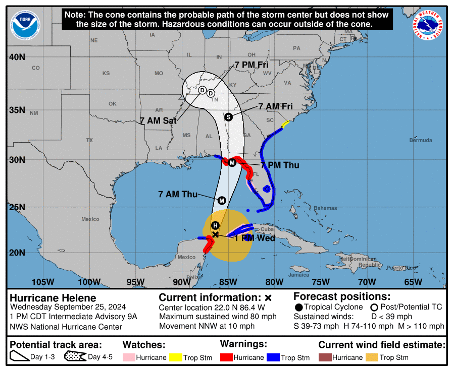
Hurricane Helene continued its intensification overnight, strengthening to a Category 2 Hurricane this morning and then to a Category 3 Hurricane this afternoon, with a clearly formed eye and estimated sustained wind speeds of 120mph (195km/h). Tropical storm-force winds are already being felt across Southwest Florida along with storm surge causing inland flooding in coastal communities. The storm will continue to strengthen throughout the day and pick up speed as it makes its final approach for landfall along the Big Bend Coast as a Major Hurricane.


There has been little change to the forecast track from the National Hurricane Center (NHC) over the last 24 hours. Hurricane Helene made its projected north-northeastward turn and it will continue along that track before making a final turn northward this afternoon before landfall later this evening.

While the exact location of landfall remains unclear, it appears that will occur in Apalachee Bay. The NHC has stated that in comparison to previous hurricanes in the Gulf of Mexico in the past decades, Helene is on the larger size and as such, its impacts will be very widespread, especially on the east side of the eye. While the massive wind field will bring tropical storm-force winds across the entire state of Florida, hurricane-force winds will be within the eyewall, along the Big Bend Coast, arriving slightly ahead of landfall this evening. These devastating hurricane-force winds are expected to be at least 120mph (195km/h) sustained with even stronger gusts expected.

Inundating rainfall causing widespread flooding is also a major concern with Hurricane Helene across Florida with over 5 inches (127mm) of rain expected along the Big Bend Coast and 2 inches (51mm) along the rest of the Gulf Coast of Florida, with lesser amounts further inland. Rainfall totals in the Apalachicola region could easily exceed 8 inches (203mm).

Along with intense winds and flooding rainfall, the biggest threat will be, to quote the NHC “catastophic and potentially unsurvivable storm surge”, particularly for the Apalachee Bay. The storm surge has already started to appear throughout the entire Florida Gulf Coast and the water levels will continue to increase as Hurricane Helene makes its final approach. Peak storm surge levels exceeding 10ft are expected from Apalachicola to Chassahowitzka and up to 20ft is possible from Carrabelle to Suwannee River.

These factors all combined have prompted widespread Hurricane and Tropical Storm Warnings, evacuations, and States of Emergencies throughout the entire state of Florida and beyond.


Forecast Track for Hurricane Helene, Courtesy of The National Hurricane Center.

With the speed and strength that Hurricane Helene will continue to gain, its impacts will be felt deep inland into the Southern Appalachians with damaging winds and intense rainfall.

Tropical storm-force winds are expected throughout Georgia and into the higher terrains of the mountains which will easily bring down trees and power lines, resulting in widespread power outages, as well as damage to property.

The Blue Ridge Mountains and Piedmont Region of Northern Georgia, Eastern Tennessee, and the Western Carolinas are also possibly looking at receiving up to 15 inches (381mm) of rain by the end of the weekend as the storm is expected to stall beginning late Friday over the Tennessee Valley. This much rain will bring a high risk of urban and flash flooding and landslides across the region. Meteorologists have already started to compare this to the 1916 flooding event in the Asheville, South Carolina area and impacts are expected to be greater than those from Tropical Storm Fred in 2021 and Hurricanes Frances and Ivan in 2004.


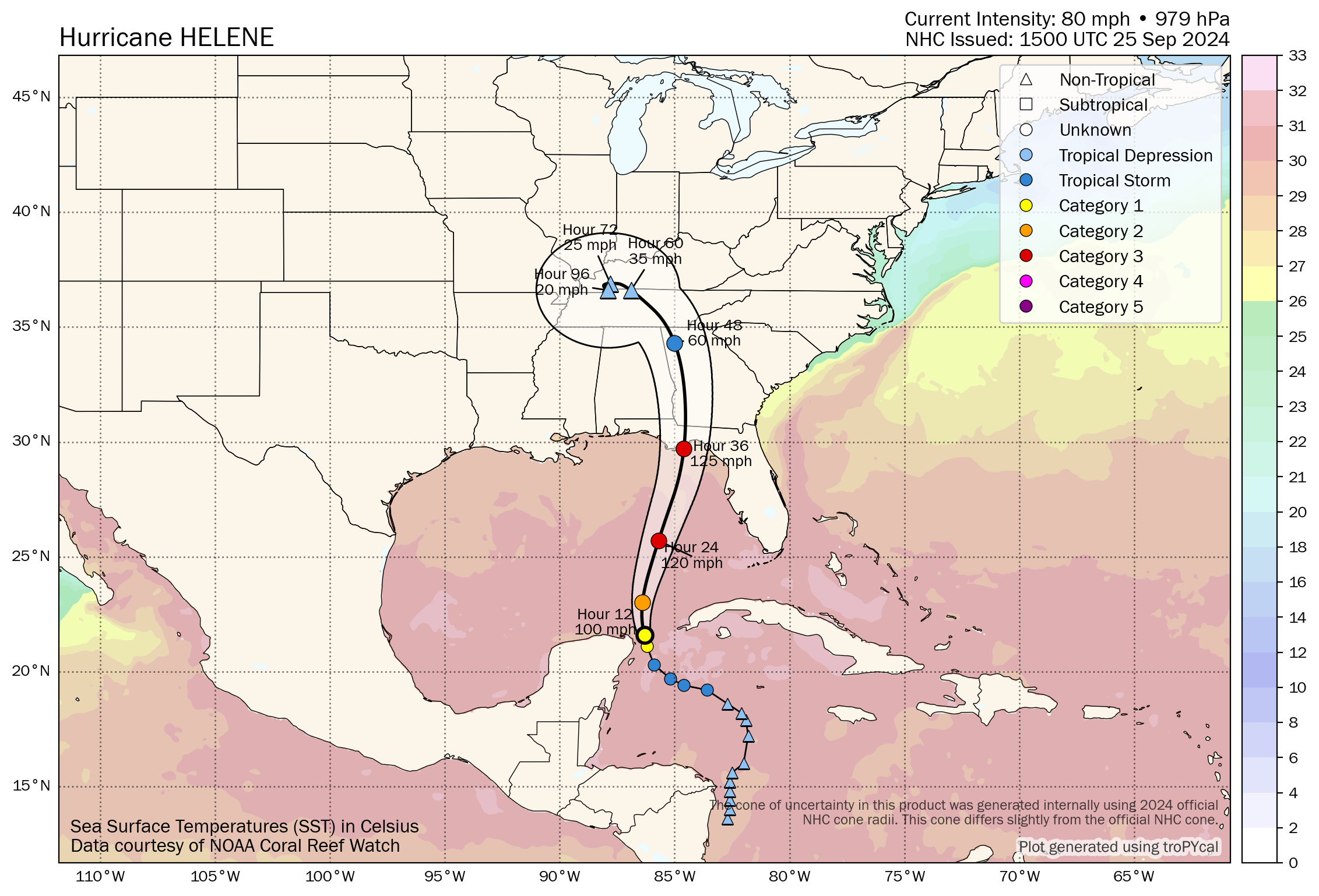
Helene will remain in an ideal environment for continued strengthening as it makes its final approach before landfall. It’s still located in an area with relatively low shear, strong upper-level divergence, as well as 30°C sea surface temperatures and warmth that extends deep below the surface. These conditions will allow the storm to further intensify from its current strength to a like high-end Category 3 Hurricane with isolated Category 4 level wind gusts.

There is still a bit of time before the storm hits to take necessary precautions to protect life and property. If you or your loved ones are in the path of the storm, please heed all directives from emergency personnel and stay safe!


Forecast Track and Intensity of Hurricane helene with Sea Surface Temperatures, courtesy of Tomer Burg.

Rapid Intensification of Helene to a Major Hurricane Expected in the Gulf as it Approaches Florida

Satellite Image of Hurricane Helene from September 25th at 11:26Am EDT, Courtesy of Colorado State University.

Tropical Storm Helene became a Category 1 Hurricane this morning as it continues to track offshore of the Yucatan Peninsula with maximum flight-level wind gusts measured at 81 knots (93mph or 150km/h) by recon flights. Based on this data, it is estimated that the maximum surface winds are 70 knots (81mph or 130 km/h). This is only the beginning of the strengthening of this storm as it is expected to rapidly intensify over the next 24 hours into a major Category 3 Hurricane as it bears down on the Florida Panhandle and Big Bend Coast.


The latest forecast track from the National Hurricane Center (NHC) shows that Helene is expected to turn northward and then north-northeastward later today and it will maintain that track as it makes landfall in Florida as a Major Hurricane.

At this point, it is still a bit too early to predict the exact location that Helene will make landfall along the Florida coast, but given the sheer size of the storm, the impacts will be widespread across the state. The storm has a massive wind field and tropical storm-force winds are already pushing their way into the Keys. These strong winds will gradually make their presence known further northward throughout the evening and overnight tonight, reaching the Panhandle tomorrow morning. Winds will increase in strength as the storm makes its final approach, with devastating hurricane-force wind gusts up to 125mph (200 km/h) projected for areas closest to where the storm will make landfall.

Inundating rainfall causing widespread flooding is also a major concern with Hurricane Helene across Florida with over 5 inches (127mm) of rain expected along the coast and lesser amounts of under 2 inches (51mm) further inland. Rainfall totals could easily exceed 10 inches (254mm) throughout the Panhandle.

Along with intense winds and flooding rainfall, life-threatening storm surge is expected along the entire Gulf Coast of Florida and the Big Bend Coast could see water levels exceeding 10ft. These factors all combined have prompted widespread Hurricane and Tropical Storm Warnings, evacuations, and States of Emergencies in almost every county in the state.


Forecast Track for Hurricane Helene, Courtesy of The National Hurricane Center.

Beyond landfall, the storm is expected to pack quite a punch through the rest of the Southeast and into the Ohio Valley with intense winds and heavy rainfall.

The destructive wind gusts will push their way well inland into Southern Georgia and even as far north as the Southern Appalachians. These strong winds will easily bring down trees and power lines, resulting in widespread power outages, as well as damage to property.

The Blue Ridge Mountain and Piedmont Regions of Northern Georgia and the Western Carolinas are also possibly looking at receiving up 12 inches (305mm) of rain by the end of the weekend as the storm is expected to stall beginning late Friday. This much rain will bring the risk of flooding and landslides across the region.


Helene will remain in an ideal environment over the next 24 hours with sea surface temperatures above 30°C, relatively low shear, and strong upper-level divergence, all key for rapid intensification of a tropical storm/hurricane. There is a bit of uncertainty of exactly how strong Hurricane Helene will become, with some weather models suggesting it could reach Category 4 strength, however, it is increasingly likely that it will make landfall as a Category 3 Hurricane.

It is not too late to take necessary precautions to protect life and property ahead of this storm. If you or your loved ones are in the path of the storm, please heed all directives from emergency personnel and stay safe!


Forecast Track and Intensity of Hurricane helene with Sea Surface Temperatures, courtesy of Tomer Burg.

Isolated Storms Could Bring Tornado Risk to Central Ontario and GTA on Wednesday

NOTE: YOU CAN CLICK ON THE MAP TO OPEN A ZOOMABLE IMAGE

As we near the end of what has been a relatively quiet month for weather across Southern Ontario, we’ve been locked in a pattern of calm conditions and unseasonably warm temperatures. But now, as we enter the first week of autumn, a shift is on the horizon!

Rainy weather has returned across much of Southern Ontario over the past few days, and unsettled conditions are expected to continue into Wednesday. There’s also potential for severe weather during the late morning, extending into the afternoon.


RAINFALL WARNING (IN GREEN) ISSUED BY ENVIRONMENT cANADA

We’re already seeing pockets of heavy rain and thunderstorms overnight, which are expected to persist until sunrise. Environment Canada has issued rainfall warnings for some areas, where localized amounts of up to 50 mm are possible.

While it's uncertain, some models indicate a slight tornado risk in the morning, particularly around the Golden Horseshoe and Niagara Region. Though this is unlikely, it’s still worth noting.

The timing of when these overnight storms clear out will be key in determining the risk for later in the morning and afternoon. According to the latest models, most storms should dissipate by sunrise, allowing the atmosphere to become more unstable heading into the late morning.


From around 11 AM through early afternoon, conditions could become favorable for isolated thunderstorms. The strongest setup is expected around Lake Simcoe, extending into the Muskoka and Haliburton regions.

While most storms are expected to remain non-severe, there is a chance of isolated tornadoes, along with marginally severe wind gusts and hail up to the size of quarters.


The Greater Toronto Area and Niagara Region are under a marginal risk for severe weather, primarily due to the potential for an isolated tornado during the afternoon and early evening. This marginal tornado risk also extends into Algonquin Park and parts of southwestern Quebec.

It’s important to keep in mind that this forecast has a high bust potential—some models show little storm development during peak hours of instability. This forecast assumes storms will develop during the afternoon, but we may need to update and downgrade the risk in the morning if it looks less likely that storms will form.

First Day of Autumn Arrives as Central and Eastern Ontario Approaches Peak Fall Colours

NOTE: YOU CAN CLICK ON THE MAP TO OPEN A ZOOMABLE IMAGE

As we entered September, it seemed like Mother Nature was eager to shift from summer to fall, with temperatures dropping to near freezing and even some northern areas witnessing the first snowflakes of the season.

But since then, the weather has taken a complete 180. Over the past few weeks, Southern Ontario has experienced a consistent pattern of above-seasonal temperatures and minimal precipitation. This unusual warmth for this time of year has slowed down the transition to fall colours across the region.

With the Autumn Equinox taking place early Sunday morning, we are officially in autumn, both meteorologically and astronomically. As we move deeper into the season, we’re starting to see some notable shifts in fall foliage, especially in Central and Eastern Ontario, according to the latest data.


If you're looking to catch the fall colours this week, your best bet is to head to higher elevations in Central and Eastern Ontario. Provincial parks such as Mikisew, Algonquin, and Bon Echo are reporting that around 40% of the leaves have started their transformation. The higher elevations experience slightly cooler overnight temperatures, which accelerates the colour change compared to other areas.

Note: The above map is extrapolated using data from OntarioParks.ca, but some parks may not have updated their latest report yet. As such, the actual colour change in your area may be further along than currently reported.

The ‘peak’ fall colours occur when at least 60% of the leaves have changed. With these parks now at 40%, we’re likely just a week or two away from peak viewing, perhaps as early as next weekend.

We’re also seeing some colour change along the Bruce Peninsula and throughout many parks in Central and Eastern Ontario, where about 30% of leaves have started changing. This includes parks like Sauble Falls, Arrowhead, Sturgeon Bay, Silent Lake, Frontenac, and Murphys Point.


For the rest of Southern Ontario, there is some minor colour change being reported, with 10-20% of leaves beginning to turn. However, peak colours are still several weeks away in these areas.

An important note: The calm weather over the past few weeks has allowed trees to hold onto most of their leaves. Without any significant wind events, the leaf fall percentage is averaging around 10-20%. If these calm conditions continue, we should see a vibrant display of colours in the weeks ahead.

Looking at the medium to long range forecast, we’re expecting slightly above-seasonal temperatures to continue through the rest of September. This could mean peak fall colours might arrive later than usual this year, although it’s hard to say for certain. We do anticipate more active weather this week, with several rounds of heavy rain possible, which could potentially knock some leaves off the trees.

Late Season Storms Bring a Slight Severe Risk for Southern Saskatchewan Tuesday Evening and Through Wednesday Morning

NOTE: YOU CAN CLICK ON THE MAP TO OPEN A ZOOMABLE IMAGE

As we continue later into September, it seems that summer is still hanging on, with some active weather this morning and into the afternoon and additional stronger severe storms beginning later this evening that will continue into Wednesday morning. The combined wind, hail, and tornado threat from the impending storms has resulted in a Slight Risk for a large portion of Southern Saskatchewan.


The storms will start to develop as individual cells along the border in the early to mid-evening in Southwest Saskatchewan. This will be followed by a line of storms from south of the border that will make their way northward into the province later in the evening and into the overnight hours. A final round of storms is expected to arrive a few hours later, spreading much further north into Central Saskatchewan and weakening later into the morning. Due to the positioning of the low pressure that these storms will the centred around, areas closer to the Alberta border could see steady moderate rainfall lasting throughout Wednesday afternoon and evening.


These storms are expected to produce hail that could be larger than a toonie, along with damaging wind gusts upwards of 100km/h, and the possibility of one or two tornadoes. There is also the concern of localized flooding, particularly further west, where the storms and the subsequent extended period of rainfall could bring up to 100mm of rain.

Slight Risk for Severe Thunderstorms in Southern Manitoba This Afternoon and Into Tuesday Morning

NOTE: YOU CAN CLICK ON THE MAP TO OPEN A ZOOMABLE IMAGE

Following some morning and early afternoon rain, Southern Manitoba can expect more active weather with severe thunderstorms beginning this afternoon and continuing into Tuesday morning. The possibility of large hail and flooding caused by heavy downpours make this a Slight Risk in Southeast and South-Central Manitoba.


The activity will begin this afternoon with a line of storms pushing northeastward into the region from North Dakota. Development of further storms will continue through the evening and into the pre-dawn hours of Tuesday, resulting in some locations seeing multiple rounds of thunderstorms. The storms that develop later into the evening could be more organized and are expected to be stronger that the afternoon storms.


These storms may bring some large hail, up to the size of a timbit, as well heavy rains that could result in areas of localized flooding. There will be some strong wind gusts that are expected to top out in the 90-100 km/h range and the possibility of an isolated tornado can not be completely ruled out.

Eyes to the Sky! Northern Lights Could Make an Appearance Across Canada on Monday

NOTE: YOU CAN CLICK ON THE MAP TO OPEN A ZOOMABLE IMAGE

A powerful solar flare, reaching an impressive X4.5 rating, erupted on Saturday, sending an Earth-directed coronal mass ejection (CME) into space. This CME is expected to impact our planet, sparking geomagnetic storm conditions that could bring the northern lights much farther south than usual across Canada on Monday.

As with most space weather events, there is some uncertainty regarding the exact timing of the CME's arrival. According to the latest data, the strongest storm conditions are anticipated during the mid to late morning hours on Monday, gradually weakening throughout the day. This suggests the best viewing opportunity for the auroras may occur in the pre-dawn hours, particularly in Western Canada.


However, this isn’t set in stone. Space weather forecasting can be tricky, and the CME might arrive later than expected, which would actually be the ideal outcome for North American skywatchers. A delayed arrival could mean a spectacular display of the northern lights over large portions of the country on Monday night.

The Space Weather Prediction Center (SWPC) is forecasting a "strong" geomagnetic storm (G3 on a scale of 5) to develop sometime on Monday. A G3 storm is potent enough to make the northern lights visible across much of Canada, provided the conditions align just right.

Historically, storms of this strength have allowed auroras to be seen as far south as Southern Ontario, and sometimes even into northern parts of the United States. In fact, the SWPC mentions the possibility of auroras being visible as far south as Pennsylvania and Iowa.


Based on the SWPC’s latest forecast, the geomagnetic storm is expected to peak between 5 AM and 11 AM EDT (2 AM to 8 AM PDT). A moderate (G2) storm is projected to continue through the day, potentially lasting until 11 PM EDT (8 PM PDT).

If this timing holds, the best chances to witness the northern lights would be in Western Canada during the early morning hours on Monday, when the storm is at its peak. Unfortunately, for those in Ontario and Quebec, the storm may hit after sunrise, reducing the likelihood of a good aurora display.

That said, if the CME arrives later in the day, it could extend the storm into Monday night, offering a better chance for Eastern Canada to catch the auroras, assuming clear skies.


IMAGE FROM WeatherBell

Speaking of skies, Monday night’s cloud forecast looks promising for much of Canada. The latest model shows most areas should have a good view, with only Southeastern Manitoba, Northwestern Ontario, and Northern Quebec facing potential cloud cover that might obscure the show.

Southern Saskatchewan and Northern Alberta may see patchy clouds but could have breaks offering decent aurora visibility. For Southern Ontario, Quebec, and most of Western Canada, skies are expected to remain clear.

Check out our free app, Instant Weather for a more in-depth cloud coverage forecast specific to your exact location.

Another potential issue will be the full moon leading to the possibility of the northern lights appearing more dim and harder to spot. However, if the storm is as strong as forecasted, there still should be some chance to capture the show despite the bright moon.


NOTE: YOU CAN CLICK ON THE MAP TO OPEN A ZOOMABLE IMAGE

Northern regions of Canada, especially Northern Quebec, the Prairies and British Columbia, are almost guaranteed to see the northern lights, except for areas in Southwestern BC near Vancouver where visibility is less certain.

Zooming into more southern regions, the likelihood of seeing auroras becomes more variable. Northeastern Ontario, including Sault Ste. Marie, Sudbury, and North Bay, along with Western and Northern Quebec, have a strong chance of aurora sightings.

In Central Ontario, places like Muskoka, Algonquin Park, Bancroft, and the Ottawa Valley also have a moderate chance, as do areas around Montreal. However, the timing of the storm’s arrival remains a key factor—if it’s delayed and peaks closer to sunset, a G3 storm would likely provide an opportunity for these regions to witness the lights.

In Southwestern Ontario, the Golden Horseshoe, and southern Quebec near the American border, the probability becomes more uncertain. There’s a low to slight chance of auroras being visible here, depending on whether the storm overperforms or peaks later in the night.


It’s important to keep in mind that light pollution can drastically affect your ability to see the northern lights. Urban areas, in particular, can drown out the skies, so you’ll need to find a dark spot away from city lights for the best chance to see the show. A resource like DarkSiteFinder can help you locate areas with low light pollution for optimal aurora viewing.


Northern Lights Timing

Many are accustomed to the precise scheduling of weather events, from thunderstorms and winter weather to solar eclipses, where timing is crucial. It’s understandable, then, that there’s a desire for a similar pinpoint timing for the best viewing of the aurora. However, the reality of predicting the best time to view the northern lights is not so straightforward.

Here’s the deal: Unlike weather events driven by terrestrial conditions, the aurora is influenced by solar activity, which is far less predictable. We can estimate that the northern lights are best viewed from just after sunset to just before sunrise, provided the skies are dark and clear. Beyond that, precise timing for peak aurora activity is challenging to forecast with current technology.


Space weather forecasting doesn't yet allow us to predict exactly when solar energy will impact Earth. We know it's coming, but how and when it interacts with our planet's magnetic field can vary. Often, we only have a few hours' notice before the solar energy is detected by satellites.

Furthermore, the intensity of the northern lights can fluctuate significantly over short periods. You might have noticed this variance if you've observed the lights before—periods of dim activity suddenly bursting into vibrant colors. This is due to the variable concentration of solar particles interacting with our atmosphere.

While we can inform you a few hours ahead when conditions are likely to be good, predicting the exact peak of aurora activity is akin to forecasting the peak of a meteor shower; we know the best night but not the best hour.


Smoky Skies Ahead as Upper-Level Wildfire Smoke Sets In Across Ontario

NOTE: YOU CAN CLICK ON THE MAP TO OPEN A ZOOMABLE IMAGE

Over the weekend, Ontario experienced an early taste of late fall weather, with flurries making an appearance in parts of Northern Ontario. Meanwhile, out west, temperatures have been heating up, fuelling a resurgence of wildfire activity.

Now, this same weather pattern has shifted into Ontario, bringing rising temperatures along with increased wildfire smoke from out west including fires in Saskatchewan and Alberta. With a stagnant air mass in place, the smoke is expected to linger over the next few days.


The good news is that most of this smoke will remain high in the atmosphere, resulting in limited impacts on air quality. However, some minor smoke may reach the surface, which could affect those sensitive to air pollution. The most noticeable effect of the smoke will be at sunrise and sunset, creating a striking orange-red hue in the sky.


MODEL MAP FROM WEATHERBELL

We began seeing smoke move into the region late Wednesday, and it’s expected to thicken overnight into Thursday. By sunrise, two pockets of heavy smoke are forecast over Southern and Northwestern Ontario.


MODEL MAP FROM WEATHERBELL

Throughout Thursday, the smoke will continue to blanket the skies, with the densest areas concentrated over Northern, Central and Eastern Ontario. Expect a stunning sunset on Thursday evening—perfect for photography!


MODEL MAP FROM WEATHERBELL

By Friday morning, the air mass will begin to shift westward, gradually clearing the smoke near the Manitoba border. However, Northeastern and Southern Ontario will likely remain under smoky conditions through Friday.

The heaviest smoke on Friday is expected along the Lake Superior and Georgian Bay shorelines.

Aside from the smoke, conditions will be ideal for this time of year, with above-average temperatures settling in across Ontario. This warm trend is expected to continue in the short term, with mild temperatures forecast into next week.

Snowy Surprise: Parts of Ontario & Quebec Could See Season’s First Snowflakes This Weekend

NOTE: YOU CAN CLICK ON THE MAP TO OPEN A ZOOMABLE IMAGE

As we enter the first full weekend of meteorological fall, Mother Nature is set to deliver a taste of autumn across Ontario and Quebec. A brief blast of cold air will cause temperatures to drop near the freezing mark during the pre-dawn hours on Saturday and Sunday.

Precipitation currently affecting Southern Ontario is expected to linger throughout the weekend. The heaviest rainfall totals are expected overnight Friday into early Saturday in Eastern Ontario, with localized amounts of 20-40 mm of rain possible.

The bigger story is when that precipitation wraps around into Western Quebec and Northeastern Ontario later on Saturday, continuing into the early morning hours of Sunday. With temperatures cooling into the low single digits and even colder air aloft, some of that precipitation may fall as wet snow.


It appears that locations like Timmins, Cochrane, Kirkland Lake, Temiskaming Shores, Deep River, and Algonquin Park in Ontario could see their first snowflakes of the season. In Quebec, areas such as Ville-Marie, Rouyn-Noranda, Amos, and Val-d'Or may also experience wet snow.

While it's unlikely that snow will accumulate, as it will be mixed with rain and ground surfaces are still too warm, there's a chance that colder-than-expected conditions could lead to a few slushy centimetres in some areas. Any accumulation will melt quickly after sunrise on Sunday as temperatures gradually rise.


NOTE: YOU CAN CLICK ON THE MAP TO OPEN A ZOOMABLE IMAGE

Speaking of Sunday morning, this is when the coldest air of this brief "cold snap" is expected across Ontario and Quebec. Morning lows will likely drop into the single digits across much of Northern and Southern Ontario and Quebec. In Northeastern Ontario and the Algonquin Park region, temperatures could dip to near freezing during the pre-dawn hours, increasing the risk of frost in addition to the potential for wet snow.

Further south, the coldest temperatures in Southern Ontario will be in the higher elevations of Central Ontario, east of Muskoka, where temperatures may plunge to around 2-5°C. It will be moderately warmer in Southwestern Ontario, the Golden Horseshoe, and Eastern Ontario, with morning lows ranging from 5-10°C. Those along the shorelines of Lake Ontario, Lake Erie, Lake Huron, and Georgian Bay will benefit from the warmer lake waters, keeping temperatures above 10°C.

In Quebec, expect low to mid-single-digit temperatures in the western portion of the province near the Ontario border on Sunday morning. Eastern Quebec, including Montréal and Québec City, will see lows in the upper single digits, ranging from 6-12°C.


WATERSPOUT RISK FOR GREAT LAKES ON SATURDAY MORNING (SORUCE: ICWR)

This cold air will also contribute to a potential waterspout outbreak over the Great Lakes this weekend. The highest risk is on Saturday, especially in the morning and afternoon, with a focus on Southern Lake Huron and Western Lake Erie. Waterspouts are also possible over Southern Georgian Bay, Western Lake Ontario, and even Lake Simcoe.

While waterspouts rarely threaten land, they can be hazardous for those on the water. In rare cases, waterspouts can come ashore, causing minor damage along the immediate shoreline.

The waterspout risk will persist into Sunday, with a focus on Eastern Lake Ontario.

Looking ahead to next week, warmer weather is expected to return to Ontario and Quebec. By late in the week, temperatures could climb back near the 30°C mark in Southern Ontario. So, while this brief taste of fall may be shocking, it looks like summer isn't quite finished yet.

Stormy Start to Long Weekend in Southern Ontario With Potential Severe Risk on Friday

NOTE: YOU CAN CLICK ON THE MAP TO OPEN A ZOOMABLE IMAGE

As we kick off the Labour Day long weekend, traditionally seen as the unofficial end of summer in Southern Ontario, we're keeping an eye on the potential for some active weather on Friday.

Friday is likely to be the warmest day of the long weekend, with temperatures soaring into the mid to high 20s during the afternoon, and the humidex making it feel into the 30s. The only exception is Eastern Ontario, where daytime highs will peak in the low to mid 20s.

This warm air will fuel thunderstorms expected to develop later in the afternoon and continue into the evening hours. The main risk zone covers Southwestern Ontario along the Lake Huron shoreline, but parts of the Golden Horseshoe and Central Ontario could also see some severe storms.


Based on the latest model data, instability will increase throughout the afternoon as daytime heating builds energy in the atmosphere. Earlier data suggested that storm development might be delayed until late evening or even overnight, which would significantly reduce the available environment to fuel these storms.

However, the newest model data shows storm development occurring much earlier, as soon as 4-5 PM—right during the prime time when conditions are most favorable. Most models agree on storms developing over Lake Huron in the late afternoon, then moving ashore between Owen Sound and Goderich. Initially, storms are likely to be isolated but could merge into a cluster as they track eastward through Grey and Bruce counties along the southern shoreline of Georgian Bay.

Additional storm development is possible to the southwest around Windsor, Sarnia, Grand Bend, and London, where the environment is actually stronger than in the north. Although there's lower confidence in storm development here, any storms that do form could become quite severe, with all hazards on the table, including a risk of an isolated tornado.


Looking towards the evening, the earlier cluster of storms is expected to reach the Lake Simcoe region by early evening. By this time, the storms will likely have lost some intensity but could still pose a marginal wind damage risk through the northern GTA and parts of Central Ontario, including Simcoe County, Muskoka, and the Kawartha Lakes region.

Storms are likely to linger into the early overnight hours across Southwestern Ontario and the Golden Horseshoe. There are indications of a flooding risk, with storms ‘training’—where multiple storms move over the same area like a train—leading to significant rainfall amounts. It’s unclear exactly where these storms might set up, but if they occur over urban areas that are more prone to flash flooding, significant flooding could occur overnight on Friday.


Currently, we’re going with a ‘slight’ (level 2/5) risk for severe storms in Southwestern Ontario on Friday. This is driven by the potential for fairly widespread damaging wind gusts. Hail up to the size of quarters and an isolated tornado risk are also possible hazards. We may need to introduce a more targeted ‘strong’ (level 3/5) risk zone in an updated forecast if confidence increases in where the storms will develop.

For those in Central Ontario and around the Golden Horseshoe, we’re assigning a ‘marginal’ (level 1/5) risk, mainly due to the potential for 90 km/h wind gusts later in the evening, along with flash flooding from multiple rounds of storms. While the tornado risk isn’t zero, it will be less of a concern by the time the storms reach these areas.


Summer’s Last Hurrah as Heat Returns to Southern Ontario & Conditional Strong Severe Threat on Tuesday

NOTE: YOU CAN CLICK ON THE MAP TO OPEN A ZOOMABLE IMAGE

Ready or not, the end of summer is rapidly approaching, with just one week left before students head back to school. Signs of autumn are already peeking through, with Environment Canada issuing a frost advisory last week in Northern Ontario, and of course, the arrival of pumpkin spice latte season!

However, it seems that Mother Nature has decided to give us one last taste of mid-summer weather. The start of this final week has brought steamy conditions, with warmer air making it feel like the 30s or even low 40s in some areas thanks to the humidex.

Along with the return of hot temperatures, we can expect some active weather, with multiple rounds of thunderstorms likely on Tuesday, possibly extending into Wednesday. While there is some uncertainty regarding the exact strength and timing of these storms, there is a risk that some could reach severe levels, bringing damaging wind gusts, large hail, and the potential for one or two tornadoes.


As mentioned, the dynamics of Tuesday’s storm risk remain highly conditional on timing. Some models suggest that decaying thunderstorm activity from Michigan could track into Southwestern and Central Ontario during the morning hours. If this occurs, it could deplete the atmospheric energy needed for storms later in the day when conditions are more favourable.

It's important to highlight that the potential for a "bust" in this event is moderately high, which is why we're focusing on the overall storm threat based on the environment, should storms develop.

The strongest conditions are expected along the southeastern shoreline of Lake Huron, extending into Deep Southwestern Ontario during the afternoon and evening hours. Storms could begin developing anytime between 12-1 PM and continue until sunset around 8 PM.


There is higher confidence in storm development further northeast around Lake Simcoe and into Central Ontario, though the environment isn't as strong in these areas. Multiple rounds of thunderstorms throughout the afternoon and early evening could impact the North Bay, Muskoka, Parry Sound, and Algonquin Park regions, with flash flooding being the primary concern.

In addition to the daytime storm risk, there are indications of a nocturnal storm risk around midnight, continuing into the pre-dawn hours of Wednesday. A strong line of storms could form over Michigan or Lake Huron and track across Southern Ontario. However, this will depend on earlier storms and how much energy remains in the atmosphere.


NOTE: YOU CAN CLICK ON THE MAP TO OPEN A ZOOMABLE IMAGE

Regarding expected storm hazards, we're assigning a 'strong' risk (level 3 out of 5) for parts of Southwestern Ontario, including Windsor, Chatham, Sarnia, Grand Bend, and London, based on the potential for widespread wind damage—again, this is conditional on storm development. Large hail up to the size of toonies and one or two tornadoes are also possible threats.

There is a widespread 'slight' risk for the rest of Southwestern Ontario and into Central Ontario. All storm hazards are possible, including strong wind gusts, large hail, and an isolated tornado. As mentioned, storms in Central Ontario could bring a flash flooding threat, with rainfall totals potentially reaching 100 to 150mm in the hardest-hit locations.


Further east, the Golden Horseshoe and a portion of Eastern Ontario are under a 'marginal' risk, where some storms later in the day or overnight could approach severe limits, primarily due to strong wind gusts and hail up to the size of quarters.

Threat of Massive Hail is the Driving Force Behind a Widespread Strong Severe Risk in Southeast Manitoba Sunday Afternoon IF Storms Develop

NOTE: YOU CAN CLICK ON THE MAP TO OPEN A ZOOMABLE IMAGE

It’s been a very active few days across the Prairies and this morning was no exception, with destructive wind gusts pummelling parts of East Central Saskatchewan and the Westman and Parkland Regions.

Unfortunately, this trend of dangerous severe weather will likely continue this afternoon, but this time the target will be Southeastern Manitoba. The possibility for massive hail across the region has resulted in this being a widespread Strong Risk for severe thunderstorms for this afternoon.


Once again, weather models are struggling with pinpointing these storms, but the ingredients for severe weather should all be in place and there is a potential for severe storm development, which warrants a forecast. Today will be an “IF day” in the sense that IF storms end up developing, they are expected to be very strong and widespread across the region. With the intense heat and temperatures feeling into the low 40s, along with ample moisture and instability, the environment will be primed for storms, but a strong enough trigger will be necessary for them to occur.

This storm development could begin early this afternoon, as the existing line of storms pushes northeastward through the Interlake Region. Behind this, additional storms could develop along a cold front and make their way eastward through the Red River Valley and Interlake Region during the afternoon and the Eastman and North Eastman Regions in the evening and overnight hours. Whether or not this development actually occurs is still uncertain.


If the severe thunderstorms end up developing this afternoon, the major threat will be very large hail. Golf ball-sized hail appears to be likely with these potential storms, with even up to tennis ball-size possible. Widespread damaging wind gusts over 100km/h would also be associated with these storms, as well as up to 100mm of rain resulting in localized flooding and the possibility of a tornado.

This could very well end up being a bust, but the threats involved in the event that storms do develop are quite significant and it’s important to be prepared.

Strong Risk for Severe Thunderstorms in Southeast Saskatchewan This Evening and Through Sunday Morning

NOTE: YOU CAN CLICK ON THE MAP TO OPEN A ZOOMABLE IMAGE

Southeastern Saskatchewan is in the crosshairs for severe weather once again, with some storms firing up along the American border later this evening followed by another round of strong storms early Sunday morning. The hail, wind, and tornado risk between the evening and morning storms makes this a Strong Risk along the southern border and a Slight Risk stretching through Southeast Saskatchewan and into East Central Saskatchewan.


The activity will begin this evening with the development of supercell storms along the Montana border that will push northeastward through the late evening. These storms could be quite strong and will be followed by even more development from south of the border after midnight. This second round is expected to be more organized and bringing more widespread impacts as they follow the northeastward trend across Southeastern Saskatchewan through the morning.


These storms could be quite impactful with very large hail that will likely be golf ball-sized, possibly even larger, and widespread damaging wind gusts upwards of 120km/h, as well as one or two tornadoes. There is also the concern of localized flooding with heavy downpours that could bring up to 100mm of rain.

Greatest Severe Thunderstorm Threat for Saturday Afternoon Shifted West; Still Slight Risk for Southern Manitoba

NOTE: YOU CAN CLICK ON THE MAP TO OPEN A ZOOMABLE IMAGE

Following this morning’s thunderstorms, we are still expecting more severe weather for Southern Manitoba later today, however the anticipated strength of those storms has diminished and the area they’re expected to hit has also changed. The strongest storms of the day are now expected in Southern Saskatchewan, but the potential for damaging winds, large hail. and localized flooding still result in a Slight Risk for severe thunderstorms in the Westman, Parkland and Northern Interlake Regions.


The exact timing of these storms is tricky to establish due to uncertainty between weather models, leaving three possible scenarios.

Scenario 1

Large storms could begin to develop in the mid-afternoon just east of the Saskatchewan border in the Parkland Region as isolated supercells which would travel northeastward across the province. Development of additional storms would continue through the evening and early overnight, following the same northeastward trajectory. These storms would then be followed by a more organized cluster of storms crossing through the region Sunday morning.

Scenario 2

Smaller storms could start to develop in the Parkland Region in the mid to late afternoon and quickly become more organized into a strong line that spreads into the Northern Interlake and travels southeastward through the evening before starting to fall apart approaching the Central Plains overnight. In this scenario, the storms Sunday morning would be weak, if they occur at all.

Scenario 3

A handful of small storms could pop-up starting in the later in the afternoon, once again in the Parkland Region, and continuing into the late evening, but not amount to anything too concerning. Then, in the early morning hours, a large cluster of storms could push northeastward into the region from Saskatchewan, followed by a second round of strong storms later in the morning.


Regardless of which of the three scenarios unfolds, it is likely that there will be strong storms in Manitoba over the next 24 hours. The threats from these storms will be the large hail, with up to toonie-size likely and damaging wind gusts that could exceed 100km/h, as well as one or two tornadoes . There is also the concern of localized flooding because these storms are expected to occur over the same area. It’s important to note that the level of uncertainty between weather models means that this could very well end up being a classic “bust” day, but we believe that it is better to be prepared in the event that any one of these scenarios materializes.

Slight and Strong Risk for Severe Thunderstorms Across Southern Manitoba Saturday, Hitting in Multiple Rounds

NOTE: YOU CAN CLICK ON THE MAP TO OPEN A ZOOMABLE IMAGE

It will be a hot day across Southern Manitoba on Saturday, but there will be some active weather, in the form of a line of severe thunderstorms, to contend with before the temperatures start to climb. More storms will hit the region later in the day, but the timing remains a little unclear. Regardless, the risk of large hail and damaging wind gusts, along with the possibility of a tornado makes this a Strong Risk for severe thunderstorms in Southwestern Manitoba, including Brandon, and a Slight Risk across much of the rest of Southern Manitoba.


The first line of storms will make their way into Southwestern Manitoba around sunrise Saturday morning, packing a punch with strong winds and large hail. These storms will lose steam as they travel eastward across the width of the province throughout the morning and into the early afternoon. Following this line of storms, it will be a hot day across the region, feeling closer to 40°C with the humidity, which should provide ample fuel for another wave of storms. The exact timing of this second line of storms is still uncertain. Some models are suggesting that the additional storms could start Saturday evening and make their way across Southern Manitoba overnight and into Sunday morning. On the other hand, there are other models that show the second line of storms developing in the early morning hours of Sunday and continuing into the early afternoon, followed by a third line of storms beginning Sunday evening. Due to this uncertainty, we will likely have a revised forecast for the secondary storm development posted Saturday afternoon.


The threats from these storms will be the large hail, with up to golf ball-size possible, as well as widespread damaging wind gusts that could exceed 100km/h and approach 120km/h, along with the possibility of a tornado or two touching down. There will also be a flooding risk, with these storms expected to bring up to 100mm, particularly to areas that will experience multiple rounds of storms.

UPDATE: Slight Risk for Severe Thunderstorms for Friday Now Extends into Calgary

NOTE: YOU CAN CLICK ON THE MAP TO OPEN A ZOOMABLE IMAGE

In an update to the forecast that was posted yesterday evening, we have extended the boundaries of the Slight Risk region to include Calgary and the entire Highway 2 corridor south of the city. The combination of damaging wind gusts, large hail, and the possibility of an isolated tornado from today’s has resulted in the Slight Risk for this area, along with Lethbridge, Medicine Hat, and Drumheller.


Thunderstorms have already begun to develop in Montana, moving northward towards the border. They will start to cross into Alberta later this afternoon and early evening, spreading across Southern Alberta throughout the rest of the evening and overnight. It’s possible that the storms could become organized into a line that will push northeastward starting later in the evening which will impact a more widespread area than just isolated storms.


The main threat from these storms will be the hail, with up to toonie to timbit-size likely, as well as damaging wind gusts that could exceed 100km/h and even approach 130km/h. At this time, there does not appear to be too much of a flooding risk, with these storms expected to bring less than 50mm of rain over the span of a few hours. An isolated tornado can also not be completely ruled out.

Slight Risk for Severe Storms in Southern Alberta to Finish the Week; Forecast Could be Upgraded

NOTE: YOU CAN CLICK ON THE MAP TO OPEN A ZOOMABLE IMAGE

Friday will be another hot day across Southern Alberta and along with that heat comes severe thunderstorms. A combination of damaging wind gusts, large hail, and the possibility of an isolated tornado means that there will be a Slight Risk in an area that includes Lethbridge, Medicine Hat and north towards Drumheller.


The storms will cross into Alberta from Montana in the south starting in the late afternoon and early evening, spreading across the region throughout the evening and overnight hours. It’s possible that the storms could become organized into a line that will push northeastward starting later in the evening that will impact a more widespread area than just isolated storms.


The main threat from these storms will be the hail, with up to toonie-size likely, as well as damaging wind gusts that could exceed 100km/h. At this time, there does not appear to be too much of a flooding risk, with these storms expected to bring less than 50mm of rain over the span of a few hours. An isolated tornado can also not be completely ruled out. The risk level could change with more data from short-range models so stay tuned for any updates to this forecast.

UPDATE: Isolated Strong Risk for Severe Storms in Southern Saskatchewan Beginning Wednesday Evening

NOTE: YOU CAN CLICK ON THE MAP TO OPEN A ZOOMABLE IMAGE

It will be another stormy day in Southern Saskatchewan on Wednesday, with active weather beginning later in the day and continuing through to Thursday morning. A combination of very large hail, damaging wind gusts and the possibility of tornadoes has led to us upgrading this forecast to a Strong risk, surrounded by a Slight Risk in the Southeastern region of the province.


The storms are anticipated to start in the early evening Wednesday in the southwest as some isolated cells. These individual storms will quickly merge and become large clusters of storms that will move northeastward across Southern Saskatchewan throughout the rest of the evening and into the early morning hours of Thursday. The storms will become more organized as they move across the province, as well as becoming more intense, thus increasing the threat from Marginal, Slight and in an isolated area that includes Regina, a Strong risk.


The main threat from these storms will be the hail, with toonie to timbit size with isolated hail up to golf ball size, as well as damaging wind gusts that could exceed 100km/h. Heavy downpours will be associated with these storms and some areas, particularly in Southeast Saskatchewan, could see over 50mm of rainfall. There is also the risk of these storms producing one or two tornadoes so be sure to keep an eye out for watches and warning being issued by Environment Canada later in the day.

Heavy Rain and Moderate Winds Will Mark Ernesto's Passage South of Newfoundland Monday

NOTE: YOU CAN CLICK ON THE MAP TO OPEN A ZOOMABLE IMAGE

While tracking Hurricane Ernesto for the past few days, there was some uncertainty between models when it came to the path that the storm would take either through or around Newfoundland. Thankfully, it became clearer, as the storm continued its approach, that it would pass south of the Avalon Peninsula, greatly limiting the impacts to land.


Ernesto restrengthened to a Category 1 Hurricane on Sunday and it will maintain that intensity as it makes its final push into Canadian waters later Monday morning. Precipitation from its outer bands will spread across most of Newfoundland as light to moderate rain starting in the mid-morning along the South Coast and moving northward across the province into the afternoon. Total rainfall amounts will be 5-20mm from this early rainfall.

By the time the storm travels to south of the Avalon Monday evening, it will have weakened to a tropical storm with wind gusts at its centre of 110km/h. The intensity of the winds will decrease further away from the centre and the strongest winds on land are expected in the Southeast Avalon, topping out at 70-90km/h. Across the rest of the Avalon and through the Burin Peninsula, wind gusts will be in the 50-70km/h range during the evening and into the overnight hours.

This is also the time frame in which Ernesto will bring the most precipitation to Southeast Newfoundland. The rain could be very heavy at times during this 6 hour window and up to 50mm could easily fall across most of the Avalon Peninsula and up to 30mm for the Burin Peninsula, with higher amounts locally. The rain and large waves from the storm could result in some coastal flooding, particularly along southwest-facing shorelines so be sure to exercise caution in these areas. By Tuesday, the storm will be well east of the island and the large waves will start to subside, marking another hurricane in the books for Newfoundland.


Forecast track for hurricane Ernesto from the Canadian Hurricane Centre - August 18th at 9Pm


Rainy Start to the Week Across the Maritimes as Hurricane Ernesto Passes Offshore

NOTE: YOU CAN CLICK ON THE MAP TO OPEN A ZOOMABLE IMAGE

While tracking Hurricane Ernesto for the past few days, it was been clear that the storm would stay well offshore of Nova Scotia. This has been good news because it means that there would be very little impact from the storm across the Maritimes. The greatest threat will be moderate to heavy surf, along with riptides, that have already begun to arrive along the Atlantic Coast of Nova Scotia this evening which will continue through the day Monday and into early Tuesday. Despite the storm staying over open water, the Maritimes can expect a wet start to the week.


A band of thunderstorms will make its way northward from Ernesto and cross in Nova Scotia shortly after midnight tonight along the length of the province, but more concentrated to the eastern mainland and Cape Breton. This will be followed by a secondary band in the mid-morning, once again focused more along the eastern half of the province. These storms will bring localized downpours and could bring up to 30mm by the lunch hour. The threat of isolated onshore storms will continue throughout the afternoon and into overnight which could push into Southern New Brunswick and across PEI with some light rain.

Meanwhile, a secondary tropical air mass will bring rain to Northern New Brunswick beginning Monday afternoon, lasting until late in the day Tuesday. This rain will be quite heavy at times, especially in the Edmundston area, and could lead to up to 50mm falling. These two rounds of precipitation make for a very interesting looking rainfall map!


Forecast track for hurricane Ernesto from the Canadian Hurricane Centre - August 18th at 9Pm