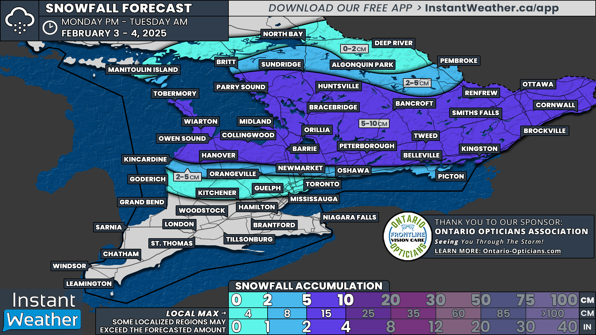
Last Year Was a Record-Breaking Tornado Season in Canada, According to Northern Tornadoes Project

The Northern Tornadoes Project (NTP), based out of Western University in London, Ontario, has just released their annual report on the 2024 tornado season. In it, the organization highlights that last year was a record-breaking year in terms of the length of the season.

Canada’s first tornado of the year was recorded in Malden Centre, Ontario on March 16th, coincidentally tying a tornado that hit Clifford, Ontario on March 16th, 2016 as the earliest recorded Ontario tornado. There were then a series of several late-season tornadoes that the NTP recorded: three individual twisters in New Brunswick on November 1st and the final tornado of the year near Fergus, Ontario on November 10th.

All told, this makes the 2024 tornado season 240 days long, over a span of nine different months. This is considerably longer than the typical season, which usually only has tornadoes in six separate months, from April to September. At this length, 2024 was the longest tornado season since at least 1980.

Another substantial finding in the report is that the 2024 tornado season was marked by the second-most tornadoes verified by the organization in a single season since their inception in 2017, with 129 tornadoes confirmed nationwide. A large spike in the total number came after the completion of the season, when the team could conduct further investigation and satellite review, which subsequently included an additional 16 tornadoes to the tally!

Most of the year’s tornadoes were rated as weak EF0s and EF1s, but the NTP did record 12 EF2 tornadoes. While this is double the amount from 2023, it is well below the 30+ recorded in both 2021 and 2022, both very active tornado seasons. Of these EF2 tornadoes, all but one (the Wolverton-Ayr tornado in Southern Ontario) occurred in forested areas of Northern Ontario and Quebec.

The Locations of all Tornadoes from 2024 and their corresponding EF-Scale Ratings, Courtesy of the Northern Tornadoes Project.

Geographically, Ontario was the province which was home to the most tornadoes this past season, with 50 tornadoes on land and 10 over water, which makes up almost half of all recorded tornadoes for the year. Out of the 50 tornadoes on land, 14 of them spawned during outbreaks on two individual days: June 29th had six and July 28th had eight. Quebec was the second-most active province, with 21 total tornadoes (four of which occurred over water), followed by Saskatchewan with 19.

At Instant Weather, we are a proud partner of the Northern Tornadoes Project. We developed our custom radar suite, Instant Weather Pro, in conjunction with the organization and the many weather reports from you, our community, help them in their mission.

For the upcoming 2025 season, the Northern Tornadoes Project team sounds excited to continue their work alongside the Northern Hail Project and the newly-founded Northern Mesonet Project. You can learn more about them at the Northern Tornadoes Project homepage and for more information regarding the report, you can find it here.

Snow Squalls to End Off the Week in Parts of Southern Ontario With Up to 25cm of Snow Possible by Friday

NOTE: YOU CAN CLICK ON THE MAP TO OPEN A ZOOMABLE IMAGE

While we’ve had a break from snow squall activity over the past week, they are expected to return as we close out the week, bringing another round of lake-effect snow to areas around Lake Huron and Georgian Bay.

As the system that brought a messy mix of wintry weather moves out, colder air will briefly settle into Southern Ontario. This drop in temperature, combined with strong westerly to northwesterly winds blowing over the still mostly ice-free lakes, will create the perfect conditions for snow squall development.

Overnight Thursday, shifting winds will likely trigger several narrow bands of heavy snow that will sweep across Southern Ontario before becoming more organized over Lake Huron and Georgian Bay.

While these bands won’t last long—most areas will only see snow for 15 to 30 minutes—they could still create hazardous driving conditions. Strong wind gusts of 70-80 km/h will cause blowing snow, significantly reducing visibility on the roads.

However, for regions within the snowbelt, which have already been hit hard by squalls in recent weeks, this could be another significant snowfall event. Parts of Grey-Bruce and Simcoe County may see totals reaching 15 to 25 cm in the hardest-hit communities by the end of Friday.

HOURLY SNOWFALL RATE/intensity - MAP FROM WEATHERBELL

More organized squalls are likely to develop early Friday morning, targeting the Bruce Peninsula and extending into Simcoe County. This narrow but intense band will likely persist throughout much of the day, though it may shift somewhat as winds fluctuate.

Current model data indicates that the heaviest snow will remain focused within the Wiarton-to-Owen Sound corridor in Grey-Bruce and between Orillia and Barrie in Simcoe County. At times, the squall could extend further inland, bringing periods of heavy snow to parts of Kawartha Lakes, Durham, and Peterborough during the morning and afternoon.

By Friday evening, a shift in wind direction will bring a few hours of intense snowfall to parts of Southern Muskoka, including MacTier, Port Carling, Bala, Gravenhurst, and Bracebridge. However, this squall is expected to weaken quickly after midnight as winds subside.

NOTE: YOU CAN CLICK ON THE MAP TO OPEN A ZOOMABLE IMAGE

With the snow band moving around throughout the day, widespread extreme accumulations are less likely, but it will allow more regions to see bursts of heavy snowfall at different times.

We’re expecting total snowfall accumulations of 15 to 25 cm across the central Bruce Peninsula, including Wiarton and Lion’s Head, extending into most of Simcoe County.

The City of Barrie is expected to avoid the worst of the snowfall, but if the squall sinks slightly farther south for a few hours, the city could still see around 10-15 cm of accumulation.

For the rest of Grey-Bruce, including Owen Sound, Hanover, and Collingwood, as well as Muskoka, Kawartha Lakes, and Peterborough, snowfall totals will generally range between 5 to 10 cm, though some localized pockets may receive up to 15 cm.

Outside of the snowbelt, snowfall will be minimal, with 2-5 cm expected across the rest of Central Ontario and less than 2 cm for Eastern Ontario and the Golden Horseshoe.

Deep Southwestern Ontario will likely remain snow-free from this round of lake-effect snow.

PRECIPITATION TYPE - MAP FROM WEATHERBELL

After the snow squalls, attention will turn to Saturday night, which, at one point, looked like it could bring Southern Ontario its strongest winter storm of the season. However, recent model data now suggests that much of the system’s moisture may stay south of the border, shifting into the U.S. Northeast instead.

If this trend continues, instead of widespread snowfall totals of 10-20 cm, most of Southern Ontario could see just 5 to 10 cm—and even that might be on the high end.

For those hoping for a big winter storm, it looks like luck isn’t on your side this time. That said, we’re still in an active storm track, and the next few weeks will bring more chances for Southern Ontario to get hit with a classic winter storm.

Southern Ontario: School Bus Cancellations for Thursday, February 6, 2025

**Please refresh your page every few minutes to receive the latest update**

Cancellation & Closure Map (English Public and Catholic Schools)

Please note: School board boundaries are a rough estimate. Don’t use this map to determine what school board or weather zone you live in as accuracy isn’t guaranteed.

  • Green = No Cancellations

  • Red = Cancellations (Click for More Details)

  • Purple = School Closures (Click for More Details)

List of Cancellations & Closures

English Public and Catholic Schools

  • Avon MaitIand Public & Huron-Perth CathoIic: There are several cancellations, please visit this link for more details: https://geoquery.hpsts.ca/Alerts

  • Grand Erie Public & Brant HaIdimand Norfolk Catholic: Busses are cancelled and schools are closed.

  • Greater Essex Public & Windsor Essex CathoIic: Area A - City of Windsor - All Board Provided Transportation is Cancelled for the day. Area B - County of Essex - All Board Provided Transportation is Cancelled for the day.

  • HaIton Public & Halton Catholic: All busses are cancelled.

  • HamiIton Wentworth Public & Catholic: There are many cancellations. Please visit this link for more details: https://hamiltonschoolbus.ca/delays.aspx

  • Lambton Kent Public & St. CIair Catholic: All busses are cancelled.

  • Niagara Public & Niagara Catholic: All busses are cancelled and schools are closed.

  • Simcoe County Public & Simcoe Catholic: All busses are cancelled for Simcoe County.

  • Thames Valley Public & London CathoIic: School purpose vehicles are CANCELLED for the day in MIDDLESEX, OXFORD, ELGIN Counties, & Red Zone due to freezing rain & icy road conditions.

  • Tri-Board: Due to the risk of freezing drizzle this afternoon school bus transportation is cancelled in Tri-Board Student Transportation Services central and northern weather zones today.

French Schools

  • Conseil scolaire de district catholique Centre-Sud: Disruption to school transport and/or the opening of certain schools in the following regions: Norfolk & Brant

  • Conseil scolaire catholique Providence: Area A - City of Windsor - All Board Provided Transportation is Cancelled for the day. Area B - County of Essex - All Board Provided Transportation is Cancelled for the day. Busses in Hamilton, Halton, Chatham-Kent, Lambton, Niagara, Simcoe, Middlesex, and Oxford are cancelled.

  • Conseil scolaire Viamonde: Busses in Hamilton, Halton, Chatham-Kent, Lambton, Niagara, Simcoe, Middlesex, and Oxford are cancelled.

Significant Winter Storm For Parts of Ontario Possible This Weekend Says Environment Canada

NOTE: YOU CAN CLICK ON THE MAP TO OPEN A ZOOMABLE IMAGE

A prolonged and dynamic winter storm is set to impact Ontario beginning Thursday, bringing a combination of heavy snow, strong winds, freezing rain, and hazardous travel conditions across multiple regions. Confidence remains high that this system will bring significant impacts, but uncertainty exists regarding the precise track and intensity of each hazard. Here’s what to expect:


Thursday, February 6, 2025

NOTE: YOU CAN CLICK ON THE MAP TO OPEN A ZOOMABLE IMAGE

East of Lake Superior
A powerful winter storm will bring heavy snowfall, strong winds, and widespread blowing snow, making travel extremely hazardous. Whiteout conditions are possible, particularly in open areas.

  • Wind gusts up to 90 km/h, especially near Lake Superior

  • Widespread snowfall with lake effect snow contributing to accumulations up to 20 cm

  • Power outages likely due to strong winds and heavy snow

  • Winds should ease late Thursday night into Friday morning

Manitoulin Island, Grey/Bruce Region, and East of Georgian Bay
Strong winds and blowing snow will create dangerous conditions across these regions Thursday evening, with near-zero visibility in exposed areas.

  • Wind gusts up to 90 km/h possible near Lake Huron and Georgian Bay

  • Loose snow and strong winds will result in blowing snow and whiteout conditions

  • Winds will ease Thursday night into Friday

North of Lake Superior
A strong snow system will move in during the morning and afternoon, leading to difficult travel conditions.

  • Snowfall amounts up to 15 cm

  • Local blowing snow may further reduce visibility

Northern and Far Northern Ontario
Snow and blowing snow will create hazardous conditions early Thursday morning, with worsening visibility in the afternoon as winds increase.

  • Snowfall amounts up to 10 cm

  • Wind gusts up to 60 km/h will lead to blowing and drifting snow, making travel difficult

Southwestern Ontario and the Greater Golden Horseshoe
A wintry mix of freezing rain and freezing drizzle could create slippery conditions overnight Wednesday into Thursday afternoon.

  • Areas around Windsor are at the highest risk of accumulating freezing rain

  • Icing may also occur across much of southern Ontario due to freezing drizzle mixed with snow

  • Roads and sidewalks could become extremely slick before temperatures rise above freezing later in the day

Northern, Central, and Eastern Ontario
A broad swath of snow will move through these regions overnight Wednesday into Thursday, leading to travel disruptions.

  • Snowfall amounts of 5 to 10 cm expected


Friday, February 7, 2025

NOTE: YOU CAN CLICK ON THE MAP TO OPEN A ZOOMABLE IMAGE

Areas Southeast of Lake Superior
Lake effect snow squalls will take hold Thursday night and persist into Friday night, producing locally heavy snowfall and whiteout conditions.

  • Snow accumulations of 15 to 25 cm possible

  • Wind gusts up to 70 km/h will create blowing snow and significantly reduced visibility, especially Friday morning

  • Road closures may occur in some areas

Bruce Peninsula and Areas Southeast of Georgian Bay
Similar to regions southeast of Lake Superior, lake effect snow squalls will develop early Friday and continue into the evening.

  • Snowfall accumulations of 10 to 20 cm possible

  • Winds gusting to 70 km/h will result in blowing snow and travel disruptions

Southern Ontario from Goderich to Oshawa
Brief but intense snow squalls combined with strong winds may create periods of dangerous driving conditions overnight Thursday into early Friday.

  • Winds gusting to 70 km/h could cause visibility to drop suddenly in blowing snow

  • Conditions should improve by Friday morning

Prince Edward County
Strong winds will sweep through Friday morning, potentially causing minor damage and tossing unsecured objects.

  • Wind gusts up to 80 km/h expected


Saturday, February 8, 2025

NOTE: YOU CAN CLICK ON THE MAP TO OPEN A ZOOMABLE IMAGE

Southern Ontario
A new low-pressure system is expected to move into the region Saturday afternoon, bringing additional snowfall that will persist into Sunday morning.

  • Snowfall amounts near 5 cm Saturday evening, with more possible Sunday

  • Some uncertainty remains regarding the timing and track of this system


Sunday, February 9, 2025

NOTE: YOU CAN CLICK ON THE MAP TO OPEN A ZOOMABLE IMAGE

Southern Ontario West of Oshawa
The storm system from Saturday will continue into Sunday, bringing a second round of snowfall.

  • Another 5 to 10 cm of snow is expected Sunday morning

  • Total snowfall accumulations of 10 to 15 cm possible

  • Difficult travel conditions anticipated

Southern Ontario North of Lake Ontario
A winter system will deliver a widespread snowfall event beginning Saturday evening and lasting into Sunday morning.

  • Snowfall accumulations of 10 to 15 cm possible

  • Uncertainty remains regarding the track, which may impact snowfall amounts


While some uncertainties remain regarding the exact intensity and placement of snowfall, wind gusts, and freezing rain, confidence is increasing that Ontario will experience a prolonged and high-impact winter event. Those with travel plans should closely monitor forecasts, as conditions may deteriorate quickly.

We’ll continue to provide updates as more details become available. Stay safe and stay prepared!


Disclaimer: These forecasts are issued by Environment Canada and typically published via their Twitter/X accounts. We receive these forecast via a daily email and often publish them for our communities to see.

'Ice Day' Forecast: Freezing Rain Likely to Cancel School Buses in Parts of Southwestern Ontario on Thursday

NOTE: YOU CAN CLICK ON THE MAP TO OPEN A ZOOMABLE IMAGE

A messy mix of wintry weather is set to move into Southern Ontario early Thursday morning, bringing a mix of snow and freezing rain depending on location. The exact impacts will vary widely across the region, with mainly light snow expected in Central and Eastern Ontario, while areas further south, particularly in Southwestern Ontario, face a higher risk of prolonged freezing rain.

Environment Canada has issued a Freezing Rain Warning for Windsor and Chatham, indicating hazardous travel conditions in these areas. With freezing rain expected to be falling right during the morning bus run, there is a strong likelihood of school bus cancellations in these regions.

The probability of cancellations decreases significantly as you move further north, where freezing rain is less of a concern. Instead, a mix of snow and ice pellets is expected, but accumulation may not be enough to meet the threshold for widespread bus cancellations.

That said, the possibility cannot be completely ruled out. As a result, we’ve assigned a very low chance of school bus cancellations across Central and Eastern Ontario. There remains a small possibility that a few isolated school boards may decide to cancel buses, particularly if Environment Canada issues a Winter Weather Travel Advisory or other alert overnight.

One key factor is that most of the snowfall accumulation will occur after school bus decisions are made early in the morning. This makes proactive cancellations less likely, especially since projected snowfall totals are expected to remain in the 5 to 10 cm range. Unless conditions deteriorate more than currently forecast, school boards will likely proceed as usual.

Here is a breakdown of the likelihood of school bus cancellations by region:

Likely (75–90% Chance)

  • Greater Essex County District School Board

  • Lambton Kent District School Board (Chatham)

Possible (50–75% Chance)

  • Lambton Kent District School Board (Sarnia & Lambton)

  • Thames Valley District School Board (Middlesex & Elgin)

Maybe (25–50% Chance)

  • Thames Valley District School Board (City of London & Oxford)

  • Avon Maitland District School Board (Exeter & Stratford)

  • Grand Erie District School Board

  • District School Board of Niagara (South)

Unlikely (10–25% Chance)

  • Avon Maitland District School Board (Goderich & Listowel)

  • STWDSTS (Wellington & Dufferin)

  • Waterloo Region District School Board

  • Peel District School Board (North)

  • Halton District School Board (North)

  • District School Board of Niagara (North)

For the rest of Southern Ontario, the chance of school bus cancellations is less than 10%.


Disclaimer: Instant Weather has zero authority when it comes to bus and school closures.

It is completely up to the school boards, bus companies, local authorities, and parents to decide what is best for their children. This is our best guess based on our forecast.

Wintry Mix of Snow, Sleet and Freezing Rain Threatens Thursday Morning Commute Across Southern Ontario

NOTE: YOU CAN CLICK ON THE MAP TO OPEN A ZOOMABLE IMAGE

A shift in the weather pattern across Southern Ontario over the past few days has brought a noticeable retreat from the extreme cold, with temperatures returning to near-seasonal values. However, this shift has also placed the region on a more active storm track, a pattern we first experienced with Monday’s messy system.

The next round of unsettled weather was initially showing signs of a prolonged freezing rain event on Thursday. However, recent model trends indicate a significantly weaker system than previously expected. While this storm will still impact Southern Ontario, the main threat now appears to be light freezing rain and snow, particularly during the Thursday morning commute.

Although snowfall totals won’t be overly impressive, Central and Eastern Ontario could see an average accumulation of 4 to 8 cm by the end of the day. The primary concern will be the mix of precipitation types, which could create slushy and icy road conditions, making for a slick and potentially hazardous commute.

Looking ahead to the weekend, we are closely watching a moisture-laden system that could bring Southern Ontario its first true widespread snowstorm of the season. This storm has the potential to impact even those regions that have largely avoided significant snowfall so far, including Deep Southwestern Ontario and the Golden Horseshoe.

Current projections suggest snowfall totals could range from 10 to 25 cm, though these estimates will likely be refined as we get closer to the event.

PRECIPITATION TYPE OVER LAST 6 HOURS - MAP FROM WEATHERBELL

Thursday’s system is expected to begin during the morning hours as light precipitation moves in from the southwest. High-resolution models, such as the American model shown above, suggest that the precipitation will be quite scattered with dry pockets throughout. However, if the precipitation takes the form of light flurries or drizzle, some models may be underestimating its extent.

For Central and Eastern Ontario, precipitation will likely fall as snow. Across the Golden Horseshoe, it may also start as snow during the mid-morning hours before transitioning. Meanwhile, areas along the Lake Erie shoreline and Deep Southwestern Ontario will be more prone to freezing rain and ice pellets from the onset.

Travel conditions could become challenging, particularly in the morning as freezing rain coincides with rush hour across Southwestern Ontario and into the Golden Horseshoe.

At this point, it’s uncertain whether this system will be strong enough to prompt widespread school bus cancellations. However, the highest risk for disruptions will be in Windsor, Chatham, and London, where precipitation is expected to begin earlier in the morning with a higher likelihood of freezing rain.

PRECIPITATION TYPE OVER LAST 6 HOURS - MAP FROM WEATHERBELL

By early afternoon, precipitation should become more widespread, particularly in Central and Eastern Ontario, as drier areas fill in with moisture. Despite this, snowfall rates are expected to remain manageable, likely staying under 1 cm per hour. However, snow could persist for a solid 6 to 8 hours through the late morning and afternoon, leading to gradual accumulation.

Meanwhile, the freezing rain threat will begin expanding toward Hamilton and the western GTA, with ice pellets potentially mixing in as the transition from snow to freezing rain occurs.

Gradually, precipitation will taper off in Deep Southwestern Ontario, with lingering drizzle as temperatures slowly rise above freezing. This slight warm-up will help melt any ice accretion from earlier in the day.

Across the rest of Southern Ontario, precipitation should wind down by late afternoon or early evening. In the wake of the system, some minor lake-effect snow may develop around Georgian Bay and Lake Huron, but we are not expecting any organized lake-effect activity at this time.

PRECIPITATION TYPE OVER LAST 6 HOURS - MAP FROM WEATHERBELL

While Thursday’s system may be relatively minor, it could serve as a precursor to a much more impactful storm set to arrive this weekend.

Uncertainties remain, and details could shift as we get closer to Saturday. However, all major weather models continue to signal a strong system targeting Southern Ontario late Saturday into Sunday.

The exact track and intensity will determine which areas see the most significant impacts. At this point, current projections suggest a prolonged freezing rain threat for Deep Southwestern Ontario and areas along the Lake Erie shoreline. Meanwhile, heavy snow, with potential accumulations between 10 and 25 cm, could affect parts of the Golden Horseshoe, Central Ontario, and Eastern Ontario.

Again, this forecast is subject to change, but this storm has the potential to be a high-impact event for much of Southern Ontario. Stay tuned, as we’ll be providing more detailed updates in the coming days!

Southern Ontario: School Bus Cancellations for Monday, February 3, 2025

**Please refresh your page every few minutes to receive the latest update**

Cancellation & Closure Map (English Public and Catholic Schools)

Please note: School board boundaries are a rough estimate. Don’t use this map to determine what school board or weather zone you live in as accuracy isn’t guaranteed.

  • Green = No Cancellations

  • Red = Cancellations (Click for More Details)

  • Purple = School Closures (Click for More Details)

List of Cancellations & Closures

English Public and Catholic Schools

  • Lambton Kent Public & St. CIair Catholic: Buses in Zones 5, 6 & 7 Cancelled due to Fog.

  • Near North Public & Nipissing-Parry Sound CathoIic: Busses are cancelled in the following regions: West Parry Sound ( Britt/Nobel - Mcdougall/Whitestone/Ahmic Harbour - Town of Parry Sound - Mactier/Humphrey/Rosseau); East Parry Sound South ( South of and excluding Hwy 522 - South River/Sundridge/Burk's Falls/Magnetawan/Katrine/Emsdale/Novar/Sprucedale)

  • Thames Valley Public & London CathoIic: School purpose vehicles in the WEST ELGIN area are CANCELLED for the MORNING ONLY due to fog.

French Schools

  • Conseil scolaire Viamonde & Conseil scolaire catholique Providence: Buses in Zones 5, 6 & 7 Cancelled due to Fog.

  • Le Conseil scolaire public du Nord-Est de l’Ontario (CSPNE) & Conseil scolaire catholique Franco-Nord: Busses are cancelled in the following regions: West Parry Sound ( Britt/Nobel - Mcdougall/Whitestone/Ahmic Harbour - Town of Parry Sound - Mactier/Humphrey/Rosseau); East Parry Sound South ( South of and excluding Hwy 522 - South River/Sundridge/Burk's Falls/Magnetawan/Katrine/Emsdale/Novar/Sprucedale)

Willie Is Wrong! February Roars Into Southern Ontario With Up to 10cm of Snow for Central & Eastern Ontario on Monday

NOTE: YOU CAN CLICK ON THE MAP TO OPEN A ZOOMABLE IMAGE

Wiarton Willie emerged from his burrow on Sunday morning and didn’t see his shadow, predicting an early spring. But as Southern Ontario residents wake up to an active weather pattern, it looks like Mother Nature may have other plans.

A stormy week is ahead, with multiple systems taking aim at the region. The first arrives Monday, bringing a messy mix of heavy snow, freezing rain, and rain. Central and Eastern Ontario will bear the brunt of the snowfall, while areas northwest of the GTA could see prolonged freezing rain.

The most significant concern, however, is a potentially high-impact storm on Thursday. Current model data points to a prolonged freezing rain event for Southwestern Ontario and the Golden Horseshoe, though the exact track remains uncertain. A slight shift north or south could change precipitation types and affected areas.

PRECIPITATION TYPE - MAP FROM WEATHERBELL

The first storm system of the week will begin affecting Southern Ontario late Monday morning. Light to moderate snow will spread into Grey-Bruce, Muskoka, Parry Sound, and areas east of Georgian Bay.

At the same time, a light freezing drizzle could develop across parts of the GTA, Kitchener, and London, though it should remain fairly light and not overly impactful. Still, untreated roads and sidewalks could become slick.

PRECIPITATION TYPE - MAP FROM WEATHERBELL

By early to mid-afternoon, the storm will intensify, with moderate to heavy snow spreading into Central and Eastern Ontario, including Ottawa, Peterborough, and Barrie.

At the same time, freezing rain may become prolonged in a narrow corridor northwest of the GTA, affecting Shelburne, Orangeville, and northern York Region.

Further south, rain will dominate along the Lake Ontario shoreline and into Southwestern Ontario.

PRECIPITATION TYPE - MAP FROM WEATHERBELL

As Monday evening approaches, the storm will begin to taper off from west to east. Snow will transition to flurries in Southwestern Ontario around dinnertime, while Central and Eastern Ontario will see precipitation continue into the evening before ending around midnight.

However, freezing rain may linger longer in higher elevations northwest of the GTA, potentially impacting Guelph and Kitchener.

NOTE: YOU CAN CLICK ON THE MAP TO OPEN A ZOOMABLE IMAGE

While this storm won’t produce extreme snowfall rates, widespread accumulation is expected across Central and Eastern Ontario. Most areas from Grey-Bruce through Muskoka, Simcoe County, Peterborough, Kingston, Ottawa, and Cornwall will see 5 to 10 cm of snow.

Localized areas near Georgian Bay could exceed expectations, as lake enhancement may fuel pockets of heavier snow, pushing some totals closer to 15 cm. However, confidence remains low in this scenario, so no forecast upgrades have been made to the 10-20 cm range.

South of these regions, snowfall amounts will drop quickly as precipitation transitions to freezing rain and rain. The northern GTA and Durham Region could see 2-5 cm of accumulation, with icing concerns in a narrow corridor stretching from Kincardine through Orangeville, Newmarket, Oshawa, Belleville, and Kingston.

NOTE: YOU CAN CLICK ON THE MAP TO OPEN A ZOOMABLE IMAGE

Freezing rain could be persistent, with most areas seeing around 2 mm of ice accretion.

However, in higher elevations like the Dundalk Highlands, up to 4 mm of ice could accumulate, increasing the risk of localized slick conditions.

PRECIPITATION TYPE - MAP FROM WEATHERBELL

As Monday’s system moves out, attention turns to a more significant storm later in the week.

A major winter storm is possible on Thursday, with global weather models consistently highlighting the risk of prolonged freezing rain. Right now, Southwestern Ontario and the Golden Horseshoe appear to be in the bullseye. However, the storm’s track remains uncertain, and even a small shift north or south could drastically alter the precipitation types and affected areas.

  • A more southerly track would favour a snowstorm for Southern Ontario.

  • A more northerly track would put Central and Eastern Ontario at risk for significant icing.

Regardless of the final path, Thursday’s storm could bring major disruptions, particularly to the morning commute. Widespread school bus cancellations appear likely based on current data, though details may change as the system evolves.

Stay tuned for updates as we track these storms!

Multi-Day Snowfall & Freezing Rain Event Targets Ontario This Week Says Environment Canada

NOTE: YOU CAN CLICK ON THE MAP TO OPEN A ZOOMABLE IMAGE

A complex and potentially high-impact winter storm is set to affect portions of Ontario this week, bringing a mix of snow, freezing rain, and difficult travel conditions over several days. While there is still some uncertainty regarding the exact track and intensity of this system, below are the details from Environment Canada’s latest forecast.


Monday: Snow & Freezing Rain for Central & Eastern Ontario

A low-pressure system tracking across Ontario will bring up to 10 cm of snowfall to parts of central and eastern Ontario on Monday. In the afternoon, there is also a risk of freezing rain or freezing drizzle, which could make roadways slick and hazardous.

NOTE: YOU CAN CLICK ON THE MAP TO OPEN A ZOOMABLE IMAGE

  • Hazard: Snow and possible freezing rain

  • Location: Central and eastern Ontario

  • Timing: Monday

  • Confidence Level: Moderate

  • Potential Impacts: Slippery roads and difficult travel conditions

NOTE: YOU CAN CLICK ON THE DISCUSSION TO OPEN A ZOOMABLE IMAGE

While this system is not expected to be particularly severe, even a light glaze of ice on top of fresh snowfall can make for treacherous road conditions. Drivers should allow extra time for travel and be prepared for rapidly changing weather conditions.


Wednesday Evening: Freezing Rain Targets Southwestern Ontario

By midweek, another low-pressure system is expected to track across southern Ontario, bringing the potential for freezing rain across portions of southwestern Ontario. Ice accumulations of 5 to 10 mm could occur, significantly increasing the risk of hazardous road conditions.

NOTE: YOU CAN CLICK ON THE MAP TO OPEN A ZOOMABLE IMAGE

  • Hazard: Freezing rain

  • Location: Southwestern Ontario

  • Timing: Wednesday evening

  • Confidence Level: Low (track and timing uncertain)

  • Potential Impacts: Significant impacts on rush hour traffic and difficult travel conditions

NOTE: YOU CAN CLICK ON THE DISCUSSION TO OPEN A ZOOMABLE IMAGE

At this point, uncertainty remains high regarding the exact location and duration of the freezing rain event. However, if ice accumulation reaches the higher end of projections, travel disruptions and potential power outages could be a concern. Stay tuned for updates as more details become available.


Overnight Wednesday into Thursday: Freezing Rain for Southern Ontario

As the system continues moving east, freezing rain may expand into portions of southern Ontario overnight Wednesday and continue into Thursday afternoon. Ice accumulation of up to 5 mm is possible, leading to potentially treacherous conditions during the Thursday morning commute.

NOTE: YOU CAN CLICK ON THE MAP TO OPEN A ZOOMABLE IMAGE

  • Hazard: Freezing rain

  • Location: Southern Ontario

  • Timing: Wednesday overnight into Thursday afternoon

  • Confidence Level: Low (track and amounts still uncertain)

  • Potential Impacts: Significant travel disruptions during morning rush hour

NOTE: YOU CAN CLICK ON THE DISCUSSION TO OPEN A ZOOMABLE IMAGE

With temperatures hovering near the freezing mark, even a thin layer of ice could make roads extremely slippery. If the system strengthens, some areas could experience prolonged freezing rain, increasing the likelihood of ice buildup on roads, trees, and power lines.


Thursday: Snow & Ice for Northern Ontario

While southern Ontario deals with freezing rain, northern regions will likely see a combination of snow and ice on Thursday. Areas in eastern and northeastern Ontario could see up to 15 cm of snowfall, along with a risk of freezing rain.

NOTE: YOU CAN CLICK ON THE MAP TO OPEN A ZOOMABLE IMAGE

  • Hazard: Snow and freezing rain

  • Location: Portions of southern and northern Ontario

  • Timing: Thursday

  • Confidence Level: Low

  • Potential Impacts: Difficult travel conditions, slippery roads, and potential power outages

NOTE: YOU CAN CLICK ON THE DISCUSSION TO OPEN A ZOOMABLE IMAGE

As with earlier parts of this system, uncertainty remains about the exact track and timing, which will determine snowfall amounts and areas most affected by ice.


Final Thoughts: Stay Alert & Prepare for Winter Hazards

While there’s still uncertainty about exact details, this system has the potential to create dangerous travel conditions across multiple days. With the possibility of accumulating snow, freezing rain, and icy roads, anyone traveling this week should stay informed and plan ahead.

✔️ Check for updates – Weather forecasts will continue to shift and change as new data becomes available.
✔️ Prepare for icy conditions – If freezing rain materializes, roads could become extremely slick, and power outages may occur.
✔️ Allow extra time for travel – Winter storms can lead to slower commutes and dangerous driving conditions.

As always, we’ll be watching this system closely and providing updates as more details emerge. Stay safe and keep an eye on our free Instant Weather app for real-time notifications!


Disclaimer: These forecasts are issued by Environment Canada and typically published via their Twitter/X accounts. We receive these forecast via a daily email and often publish them for our communities to see. We also zoom them in and add more city & town names for more significant events to ensure our community can quickly determine where they are located on the map and what impacts may affect them.

Southern Ontario: School Bus Cancellations for Wednesday, January 29, 2025

**Please refresh your page every few minutes to receive the latest update**

Cancellation & Closure Map (English Public and Catholic Schools)

Please note: School board boundaries are a rough estimate. Don’t use this map to determine what school board or weather zone you live in as accuracy isn’t guaranteed.

  • Green = No Cancellations

  • Red = Cancellations (Click for More Details)

  • Purple = School Closures (Click for More Details)

List of Cancellations & Closures

English Public and Catholic Schools

  • Avon MaitIand Public & Huron-Perth CathoIic: There are widespread bus cancellations and some school closures. Visit this link for more details: https://hpsts.mybusplanner.ca/Alerts

  • BIuewater Public & Bruce-Grey Catholic: There are widespread bus cancellations and school closures. Visit this link for more details: https://mybrucegreyschoolbus.ca/Cancellations.aspx

  • Dufferin-PeeI Catholic: Buses to St Andrew, St Peter, St Benedict, RF Hall and buses in STOPR Zone 3 are cancelled

  • Durham Public & Durham Catholic: Busses are cancelled in Zone 1 (Brock).

  • HaIton Public & Halton Catholic: Busses in Zone 3 (Halton Hills) are cancelled.

  • Kawartha Pine Ridge Public & Peterborough Victoria Northumberland Clarington Catholic: All busses are cancelled.

  • Near North Public & Nipissing-Parry Sound CathoIic: Buses are cancelled in the following regions: All busses for West Parry Sound (Britt/Nobel - Mcdougall/Whitestone/Ahmic Harbour - Town of Parry Sound - Mactier/Humphrey/Rosseau) are cancelled.

  • Ottawa CarIeton Public & Ottawa Catholic: All busses are cancelled.

  • Renfrew County Public & Renfrew County Catholic: All busses are cancelled.

  • Simcoe County Public & Simcoe Catholic: All busses are cancelled.

  • Tri-Board: All busses are cancelled.

  • Trillium Lakelands: All busses are cancelled.

  • Upper Canada Public & Eastern Ontario CathoIic: All busses are cancelled.

  • Upper Grand Public & Wellington CathoIic: Busses are cancelled in North Wellington (Division 3) and Dufferin County (Division 4). Schools in North Wellington and Dufferin County are closed.

  • WaterIoo Public & WaterIoo Catholic: Busses in Wellesley, Wilmot and Woolwich Townships are cancelled

French Schools

  • Conseil scolaire de district catholique Centre-Sud: There are several bus cancellations. Visit this link for details: https://www.cscmonavenir.ca/ecole/

  • Conseil scolaire de district catholique de l'Est Ontarien: All busses are cancelled.

  • Conseil des écoles catholiques de langue française du Centre-Est: Busses are cancelled in: Arnprior, Brockville, Carleton Place, Almonte, Renfrew County (schools in Pembroke), United Counties of Prescott-Russell, Kingston, Marionville, Merrickville and Kemptville, Ottawa, and Trenton.

  • Conseil scolaire Viamonde & Conseil scolaire catholique Providence: There are multiple cancellations. Please visit this link for details: https://infobus.francobus.ca/cancellations.aspx

'Snow Day' Forecast: Alberta Clipper Likely to Cause Widespread School Bus Cancellations Across Southern Ontario on Wednesday

NOTE: YOU CAN CLICK ON THE MAP TO OPEN A ZOOMABLE IMAGE

Heavy snow is currently sweeping across Southern Ontario as an Alberta Clipper makes its way through the region. By Wednesday morning, this system is expected to deliver widespread snowfall totals of up to 15 cm across Eastern, Central, and Southwestern Ontario.

In addition to the snowfall from the system itself, lake effect snow will develop in the wake of the clipper, primarily around Lake Huron and Georgian Bay.

These squalls are expected to begin during the late morning and continue into Wednesday afternoon. Environment Canada has issued snow squall watches for these regions, which are likely to be upgraded to warnings by early Wednesday.

With heavy snow persisting overnight and the added impact of lake effect snow during the day, it is highly likely that school boards in affected areas will cancel school buses on Wednesday.

Most of the snow from the Alberta Clipper will fall Tuesday evening and taper off overnight for areas outside the snowbelt. However, rural regions may still struggle to clear backroads in time for the morning commute. This was evident on Tuesday when widespread cancellations occurred despite the snow ending hours before the morning bus runs.

Conditions on Wednesday are expected to be similar or even worse in some areas, particularly in Eastern Ontario, where snow will still be falling during the early morning hours.

The greatest likelihood of a "snow day" will be in rural school boards in Eastern Ontario, which are typically more cautious when it comes to heavy snow. Grey, Bruce, and Huron counties are also strong candidates for cancellations, as these areas are still digging out from previous snowfalls and are expected to see additional squalls on Wednesday.

For the rest of Central and Eastern Ontario, school bus cancellations remain uncertain. Decisions will largely depend on local road conditions and how efficiently crews can clear roads, especially critical backroads.

Urban areas like Ottawa and the Greater Toronto Area are not expected to experience enough snow to trigger bus cancellations. However, Ottawa has a slightly higher chance than Toronto due to ongoing snowfall during the early morning hours, which may make the roads more difficult to clear.

Here is a breakdown of the likelihood of school bus cancellations by region:

Almost Certain (90–99% Chance)

  • Avon Maitland District School Board (Goderich)

  • Bluewater District School Board (Kincardine & Southampton)

  • Tri-Board (North Hastings, North L&A & North Frontenac)

Likely (75–90% Chance)

  • Avon Maitland District School Board (Exeter, Stratford & Listowel)

  • Bluewater District School Board (Bruce Peninsula, Owen Sound, Meaford & Hanover)

  • Simcoe County District School Board (West Zone)

  • Kawartha Pine Ridge District School Board (Peterborough)

  • Trillium Lakelands District School Board (Haliburton)

  • Tri-Board (Centre Hastings, Central L&A & South Frontenac)

  • Renfrew County District School Board (Madawaska)

  • Upper Canada District School Board

Possible (50–75% Chance)

  • STWDSTS (Wellington & Dufferin)

  • Simcoe County District School Board (Central & North Zone)

  • Trillium Lakelands District School Board (Muskoka & CKL)

  • Near North District School Board (Town of Parry Sound)

  • Kawartha Pine Ridge District School Board (Northumberland)

  • Tri-Board (Belleville, Prince Edward County, South L&A & Kingston)

  • Renfrew County District School Board (Renfrew & Pembroke)

Maybe (25–50% Chance)

  • Thames Valley District School Board (Middlesex & Oxford)

  • Waterloo Region District School Board

  • Simcoe County District School Board (South Zone)

  • Near North District School Board (East Parry Sound)

  • Kawartha Pine Ridge District School Board (Clarington)

  • Ottawa-Carleton District School Board

Unlikely (10–25% Chance)

  • Thames Valley District School Board (London & Elgin)

  • Halton District School Board (North)

  • Peel District School Board (North)

  • York Region District School Board

  • Durham District School Board (North)

  • Near North District School Board (North Bay)

  • Rainbow District School Board

  • Algoma District School Board

For the rest of Southern Ontario, the chance of school bus cancellations is less than 10%.


Disclaimer: Instant Weather has zero authority when it comes to bus and school closures.

It is completely up to the school boards, bus companies, local authorities, and parents to decide what is best for their children. This is our best guess based on our forecast.

Another Dumping of Snow as an Alberta Clipper Targets Southern Ontario With Up to 20cm of Snow by Wednesday

NOTE: YOU CAN CLICK ON THE MAP TO OPEN A ZOOMABLE IMAGE

As January 2025 draws to a close, Southern Ontario’s weather has varied greatly depending on the region.

Snowbelt areas near Lake Huron and Georgian Bay have been bombarded by persistent lake-effect snow over the past couple of weeks. Meanwhile, Eastern and Deep Southwestern Ontario have seen little snow this month, as no significant systems have impacted those areas.

That pattern is about to shift, with an Alberta Clipper poised to bring a widespread snowfall event across Southern Ontario. This system is expected to deliver 10 to 20 cm of snow to Eastern, Central, and Southwestern Ontario over the next 24 hours, including the snowbelt regions.

In addition to the clipper, snow squalls are forecast to develop Wednesday afternoon and continue into the evening. Combined system snow and lake effect snow could bring an additional 20 to 30 cm to areas east of Lake Huron between Tuesday and Wednesday.

PRECIPITATION TYPE - MAP FROM WEATHERBELL

Snowfall from the clipper has already begun moving into Southwestern Ontario near Lake Huron as of late Tuesday afternoon.

Moderate to heavy snow will spread eastward through the evening, with the heaviest snow expected in the Greater Toronto Area (GTA) and Central Ontario during the late afternoon and early evening.

Localized heavier snow is likely along the Lake Huron and Georgian Bay shorelines, particularly over the Bruce Peninsula, where lake enhancement will add extra moisture to the system.

PRECIPITATION TYPE - MAP FROM WEATHERBELL

For Southwestern Ontario, snowfall will begin to taper off by the evening and should exit areas southwest of Lake Simcoe by midnight.

Central and Eastern Ontario will continue to see snow through the early overnight hours, with the Ottawa Valley potentially experiencing snowfall until Wednesday morning, tapering off around sunrise.

HOURLY SNOWFALL RATE/intensity - MAP FROM WEATHERBELL

Following the system’s departure, lake effect snow is expected to ramp up over Lake Huron and Georgian Bay.

Models indicate disorganized snow bands developing off Lake Huron on Wednesday afternoon, impacting areas like Grey, Bruce, Huron, and Perth counties. These bands may occasionally extend as far as Kitchener and Hamilton.

Additionally, a snow squall may form southeast of Georgian Bay, bringing heavy snow to the Barrie and Innisfil areas Wednesday afternoon. The intensity and duration of this squall remain uncertain.

By Wednesday evening, activity over Lake Huron may consolidate into a stronger squall targeting the corridor between Southampton and Kincardine, potentially extending to the Hanover area. This squall could lead to rapid snowfall accumulation before gradually weakening after midnight.

NOTE: YOU CAN CLICK ON THE MAP TO OPEN A ZOOMABLE IMAGE

The highest snowfall totals over the next 24 hours are expected in the Grey-Bruce region.

Communities such as Port Elgin, Kincardine, Owen Sound, Chatsworth, Mildmay, and Hanover are forecast to receive 10 to 15 cm of snow from the clipper and an additional 10 to 20 cm from lake effect snow on Wednesday.

This could bring total accumulations to 20 to 30 cm, with isolated pockets potentially exceeding 30 cm.

Across Central and Eastern Ontario, Alberta Clipper snowfall is generally expected to range from 10 to 15 cm. Areas southeast of Georgian Bay, including Barrie, may see near 20 cm due to the added snow from Wednesday afternoon’s localized squalls.

Lower totals are expected in the GTA and Niagara regions, as the system’s moisture will primarily focus further north, and lake enhancement will not play a role.

Snowfall amounts in the GTA are expected to range from 4 to 8 cm, with Hamilton and the Niagara corridor seeing even less at 2 to 4 cm.

Deep Southwestern Ontario, including Windsor, Chatham, Sarnia, and London, will see little to no snow from this system. London could receive a few centimetres, while Windsor may only see a trace.

Looking ahead, we are monitoring a potential system moving in on Friday, which could bring snow and freezing rain to parts of Southern Ontario. Stay tuned for updates.

Southern Ontario: School Bus Cancellations for Tuesday, January 28, 2025

**Please refresh your page every few minutes to receive the latest update**

Cancellation & Closure Map (English Public and Catholic Schools)

Please note: School board boundaries are a rough estimate. Don’t use this map to determine what school board or weather zone you live in as accuracy isn’t guaranteed.

  • Green = No Cancellations

  • Red = Cancellations (Click for More Details)

  • Purple = School Closures (Click for More Details)

List of Cancellations & Closures

English Public and Catholic Schools

  • Avon MaitIand Public & Huron-Perth CathoIic: There are bus cancellations and school closures, please visit this link for more details: https://geoquery.hpsts.ca/Alerts

  • BIuewater Public & Bruce-Grey Catholic: There are several cancellations, please visit this link for more details: https://www.mybrucegreyschoolbus.ca/Cancellations.aspx

  • Dufferin-PeeI Catholic & Peel Public: Buses to St Andrew, St. Peter, St. Benedict and RF Hall are cancelled today

  • Kawartha Pine Ridge Public & Peterborough Victoria Northumberland Clarington Catholic: All transportation is cancelled today in Northumberland and Peterborough City and County.

  • Simcoe County Public & Simcoe Catholic: All busses are cancelled.

  • Thames Valley Public & London CathoIic: There are several cancellations. Please visit this link for more details: https://transportation.mybigyellowbus.ca/Cancellations.aspx

  • Tri-Board: School transportation is cancelled in Tri-Board’s western weather zones today.

  • Trillium LakeIands: Transportation is cancelled in all zones.

  • Upper Grand Public & Wellington CathoIic: All school taxis and buses in North Wellington (Division 3) and Dufferin County (Division 4) will not be operating today.

  • WaterIoo Public & WaterIoo Catholic: There are multiple cancellations, please visit this link for more details: https://bpweb.stswr.ca/Cancellations.aspx

French Schools

  • Conseil scolaire de district catholique Centre-Sud: There are multiple cancellations. Visit this link for a complete list: https://www.cscmonavenir.ca/ecole/

  • Conseil des écoles catholiques de langue française du Centre-Est: Transportation is cancelled for Trenton.

  • Conseil scolaire Viamonde & Conseil scolaire catholique Providence: There are multiple cancellations. Visit this link for a complete list: https://infobus.francobus.ca/cancellations.aspx

'Snow Day' Forecast: Will Grey-Bruce Ever Go Back to School? Another Day of Bus Cancellations Possible on Tuesday

NOTE: YOU CAN CLICK ON THE MAP TO OPEN A ZOOMABLE IMAGE

Heavy snow is set to sweep across Southern Ontario on Monday evening, bringing blizzard conditions and widespread blowing snow. The combination of reduced visibility and drifting snow will make travel hazardous in many areas.

Fortunately, in most regions, the snowfall is expected to taper off well before Tuesday morning. Winds will also weaken significantly overnight, leading to improved conditions by the time the morning bus run begins. Because of this, we do not anticipate widespread school bus cancellations across Southern Ontario on Tuesday.

However, the arrival of much colder air overnight will trigger lake-effect snow bands east of Lake Huron and south of Georgian Bay. Environment Canada has issued snow squall warnings and watches for these areas, warning of poor travel conditions that could persist into Tuesday morning.

As a result, school bus cancellations are likely in regions such as Grey, Bruce, Huron, and Perth counties, where snowfall and blowing snow could create treacherous driving conditions. For students in Grey-Bruce, this could mark their seventh consecutive snow day, following cancellations last week and on Monday.

The heaviest snowfall from this system is expected in the Parry Sound and North Bay regions, where totals of up to 20 cm are possible. Given the school board's cautious approach to winter weather, there is a slight chance of cancellations in these areas, even if conditions improve significantly by the morning.

Here is a breakdown of the likelihood of school bus cancellations by region:

Likely (75–90% Chance)

  • Avon Maitland District School Board (Goderich & Exeter)

  • Bluewater District School Board (Kincardine and Meaford)

Possible (50–75% Chance)

  • Avon Maitland District School Board (Listowel & Stratford)

  • Bluewater District School Board (Southampton, Hanover, Owen Sound & Bruce Peninsula)

  • Simcoe County District School Board (West Zone)

Maybe (25–50% Chance)

  • Near North District School Board (All Zones)

Unlikely (10–25% Chance)

  • Thames Valley District School Board (Middlesex)

  • STWDSTS (Wellington & Dufferin)

  • Simcoe County District School Board (Central & North Zone)

  • Trillium Lakelands District School Board (Muskoka, Haliburton & North CKL)

  • Rainbow District School Board

For the rest of Southern Ontario, the chance of school bus cancellations on Monday is less than 10%.


Disclaimer: Instant Weather has zero authority when it comes to bus and school closures.

It is completely up to the school boards, bus companies, local authorities, and parents to decide what is best for their children. This is our best guess based on our forecast.

Southern Ontario: School Bus Cancellations for Monday, January 27, 2025

**Please refresh your page every few minutes to receive the latest update**

Cancellation & Closure Map (English Public and Catholic Schools)

Please note: School board boundaries are a rough estimate. Don’t use this map to determine what school board or weather zone you live in as accuracy isn’t guaranteed.

  • Green = No Cancellations

  • Red = Cancellations (Click for More Details)

  • Purple = School Closures (Click for More Details)

List of Cancellations & Closures

English Public and Catholic Schools

  • BIuewater Public & Bruce-Grey Catholic: There are several cancellations and even some CLOSURES, please visit this link for more details: https://mybrucegreyschoolbus.ca/Cancellations.aspx

  • Dufferin-PeeI Catholic: Buses to St. Peter, St. Andrew, St. Benedict and RF Hall are cancelled today due to winter weather conditions. All schools are open.

  • Near North Public & Nipissing-Parry Sound CathoIic: Bussing for all weather corridors are cancelled today. At this time, all schools remain open for students who can get there safely.

  • Peel Public: here are cancellations for Peel Public. Visit https://businfo.stopr.ca/Cancellations.aspx for details.

  • Simcoe County Public & Simcoe Catholic: Busses are cancelled in the North Zone and the West Zone

  • Upper Grand Public & Wellington Catholic: All school taxis and buses in North Wellington will not be operating today. All school taxis and buses in Dufferin County will not be operating today.

French Schools

  • Conseil scolaire Viamonde & Conseil scolaire catholique Providence: Busses are cancelled in the Simcoe North Zone and the SImcoe West Zone.

  • Le Conseil scolaire public du Nord-Est de l’Ontario (CSPNE) & Conseil scolaire catholique Franco-Nord: Bussing for all weather corridors are cancelled today for Near North & Nipissing-Parry Sound area. At this time, all schools remain open for students who can get there safely.

'Snow Day' Forecast: Looming Blizzard Risk Could Cancel School Buses in Parts of Southern Ontario on Monday

NOTE: YOU CAN CLICK ON THE MAP TO OPEN A ZOOMABLE IMAGE

A mix of strong wind gusts and heavy snowfall is expected to create blizzard conditions starting Monday afternoon across parts of Southern Ontario.

Environment Canada has issued a blizzard warning for areas along the Eastern Georgian Bay shoreline, with a weather advisory extending through Muskoka and into Northern Ontario. These alerts signal the potential for hazardous weather, with significant impacts on visibility and travel conditions.

Given the seriousness of the situation, it is likely that school boards in the most affected regions will cancel school buses on Monday. However, for much of Southwestern and Eastern Ontario, widespread bus cancellations appear less likely. This is because the worst of the weather is expected to develop after the afternoon bus run, reducing the chances of a "snow day" for most students in these areas.

In regions where Environment Canada has issued blizzard warnings or advisories, conditions could deteriorate quickly during the afternoon hours. Central Ontario, including Muskoka, is expected to experience snow starting as early as 2 PM. In these areas, proactive decisions by school boards will be crucial to ensure safety, especially for students returning home in worsening weather.

For other parts of Southern Ontario, where the snow and strong winds are not expected to intensify until later in the day, the afternoon bus run should proceed without issue.

Ultimately, whether buses are cancelled will depend on how each school board interprets the forecast and balances the safety of students with the logistical realities of the storm’s timing. The further southeast you are located, the lower the chance of bus cancellations on Monday.

Here is a breakdown of the likelihood of school bus cancellations by region:

Almost Certain (90% Chance)

  • Near North District School Board (All Zones)

Likely (75–90% Chance)

  • Trillium Lakelands District School Board (Muskoka)

  • Rainbow District School Board

  • Algoma District School Board

Possible (50–75% Chance)

  • Bluewater District School Board (Bruce Peninsula)

  • Trillium Lakelands District School Board (Haliburton)

Maybe (25–50% Chance)

  • Bluewater District School Board (Kincardine, Southampton, Owen Sound, Hanover & Meaford)

  • Simcoe County District School Board (North & West Zone)

  • Trillium Lakelands District School Board (North CKL)

  • Tri-Board (North Hastings)

  • Renfrew County District School Board (Madawaska, Pembroke & Petawawa)

Unlikely (10–25% Chance)

  • Avon Maitland District School Board (Goderich & Listowel)

  • STWDSTS (Wellington & Dufferin)

  • Simcoe County District School Board (Central & South Zone)

  • Trillium Lakelands District School Board (South CKL)

  • Kawartha Pine Ridge District School Board (Peterborough)

  • Tri-Board (Centre Hastings, North L&A & North Frontenac)

For the rest of Southern Ontario, the chance of school bus cancellations on Monday is less than 10%.


Disclaimer: Instant Weather has zero authority when it comes to bus and school closures.

It is completely up to the school boards, bus companies, local authorities, and parents to decide what is best for their children. This is our best guess based on our forecast.

Damaging Wind Storm Sweeps Into Ontario With Gusts Over 90 km/h and Blizzard Conditions on Monday

NOTE: YOU CAN CLICK ON THE MAP TO OPEN A ZOOMABLE IMAGE

The final week of January is shaping up to start with turbulent weather across Southern Ontario, as a damaging windstorm is set to impact the region on Monday.

Wind gusts are forecasted to reach 80 to 90 km/h across much of Southern Ontario during the day on Monday, with some localized pockets potentially seeing gusts exceeding 100 km/h.

Power outages are a significant concern for the hardest-hit regions, along with other types of wind-related damage, such as fallen tree branches and unsecured objects being blown around. In addition, the strong winds may create another hazard along the Great Lakes shoreline, where ice could be pushed ashore, causing damage to property along the lakes.

Adding to the danger, a sharp cold front is expected to sweep through Ontario over the next 24 hours, bringing a blast of wintry weather, including an intense frontal snow squall. Combined with the strong winds, some areas could experience blizzard-like conditions starting late Monday afternoon and lasting into the evening.

While this event isn’t expected to bring significant snowfall totals to Southern Ontario, accumulations could range from 5 to 15 cm, depending on the location.

However, areas east of Lake Superior in Northern Ontario may see higher amounts, with localized totals reaching 20 to 30 cm, while a broader area of Northeastern Ontario is expected to receive 10 to 20 cm.

NOTE: YOU CAN CLICK ON THE MAP TO OPEN A ZOOMABLE IMAGE

The windstorm is expected to begin early Monday morning across Southern Ontario, with wind speeds gradually increasing through mid-morning.

Southwestern Ontario, particularly areas along the Lake Huron shoreline, will experience the strongest winds first, around sunrise. These conditions will then spread east and north by early afternoon.

The strongest winds are anticipated during the early to mid-afternoon hours, with widespread gusts ranging from 70 to 90 km/h across the region.

Areas such as the Dundalk Highlands, Niagara region, Northern Lake Erie shoreline, and Prince Edward County could see slightly higher wind gusts due to their exposure to the lakes and elevated terrain. Gusts in these areas may exceed 100 km/h, possibly reaching 105 to 110 km/h near Collingwood along the Georgian Bay shoreline.

Other locations, including Goderich, Kincardine, Owen Sound, Wiarton, Tobermory, Guelph, Kitchener, Hamilton, Brantford, Britt, Parry Sound, Belleville, Kingston, and Brockville, could experience wind gusts between 90 and 100 km/h. This range represents the greatest potential for wind damage, including localized power outages.

The remainder of Southern Ontario—excluding Deep Southwestern Ontario and the Ottawa Valley—can expect gusts between 80 and 90 km/h, with occasional stronger gusts. Deep Southwestern Ontario and the Ottawa Valley are likely to see slightly weaker winds, with maximum gusts of 70 to 80 km/h.

For those with properties along the Great Lakes, particularly Lake Erie, the risk of ‘ice shoves’—where winds push broken ice onto shore—is a concern. This phenomenon can cause significant damage and flooding along the shoreline. Residents in affected areas should prepare for this potential over the next 24 hours.

PRECIPITATION TYPE - MAP FROM WEATHERBELL

Wind speeds are expected to diminish somewhat later in the afternoon and into Monday evening, though they will remain strong, ranging from 60 to 90 km/h. This coincides with the arrival of a pocket of moderate to heavy snow in Central Ontario during the late afternoon.

The snowfall is expected to begin affecting the Parry Sound and Muskoka regions between 2:00 and 4:00 PM, leading to blowing snow and possible blizzard conditions lasting several hours into the evening.

Travel during this time will likely be hazardous, with significantly reduced visibility and potentially closed roads. While snowfall rates won’t be overwhelming, at a few centimetres per hour, the strong winds will make conditions dangerous.

Travel should be avoided unless absolutely necessary. Fortunately, conditions are expected to improve within a few hours.

PRECIPITATION TYPE - MAP FROM WEATHERBELL

By dinnertime, widespread snowfall is likely across most of Central Ontario, portions of Eastern Ontario, and areas east of the Lake Huron shoreline.

The worst conditions are expected early in the event, as the snow begins and winds are strongest, with gradual improvement into the later evening hours.

The greatest risk of blizzard conditions will be across Grey-Bruce, the Georgian Bay shoreline, Muskoka, and Parry Sound, where the heaviest snow and strongest winds are forecasted to overlap.

PRECIPITATION TYPE - MAP FROM WEATHERBELL

An intense, narrow band of snow is also expected to develop along the cold front as it moves through Southern Ontario in the evening.

This frontal snow squall could bring a sudden burst of heavy snow almost everywhere in Southern Ontario, lasting less than an hour.

The squall is expected to reach Central and Eastern Ontario by mid to late evening, while the Greater Toronto Area and Niagara region may not experience it until closer to midnight.

This squall is not expected to produce significant snowfall totals, as it will pass through quickly. However, it could bring 2 to 5 cm of snow within 15 to 30 minutes, along with brief but intense blowing snow.

Although conditions may feel like a blizzard during this time, they likely won’t meet the official criteria, which require blizzard conditions to last at least four hours. That criteria is more likely to be met around the Lake Huron and Georgian Bay shoreline as the snow starts earlier in the day.

NOTE: YOU CAN CLICK ON THE MAP TO OPEN A ZOOMABLE IMAGE

By the end of Monday, the highest snowfall totals are expected in the higher elevations of Central Ontario, including Huntsville, Sundridge, Algonquin Park, and North Bay, where accumulations of 10 to 20 cm are likely, though closer to the lower end of that range.

For the rest of Central Ontario and areas east of Lake Huron, including Hanover, Orangeville, and Collingwood, this event is expected to bring 5 to 10 cm of fresh snowfall.

Eastern Ontario and the Lake Huron shoreline should see 2 to 5 cm, primarily from the passing snow squall.

The Golden Horseshoe and Deep Southwestern Ontario are likely to receive less than 2 cm of snow.

NOTE: YOU CAN CLICK ON THE MAP TO OPEN A ZOOMABLE IMAGE

In Northern Ontario, snow will begin late Sunday night and continue through much of Monday.

The heaviest accumulations will occur east of Lake Superior, where lake enhancement and embedded snow squalls could push totals to 20 to 30 cm in areas like Wawa and Sault Ste. Marie.

Blizzard conditions are possible during the morning and afternoon in these regions, with wind gusts reaching 70 to 90 km/h near the shoreline.

The rest of Northeastern Ontario, stretching from North Bay to Cochrane along the Quebec border, is expected to receive 10 to 20 cm of snow by the end of Monday.

Sudbury, which may find itself in a dry pocket, is forecasted to see 5 to 10 cm, closer to the lower end of that range, while Elliot Lake should receive less than 5 cm.

Snow Squalls Return to Southern Ontario This Weekend With Up to 20cm of Snow; Potential Wind Storm on Monday

NOTE: YOU CAN CLICK ON THE MAP TO OPEN A ZOOMABLE IMAGE

Southern Ontario has been gradually climbing out of the deep freeze earlier this week, which brought wind chills plunging into the -30s. This temporary reprieve has also slowed down the lake-effect snow machine.

However, a fresh surge of cold air over the next 24 hours will reignite the potential for snow squalls, particularly around Georgian Bay.

The good news is that this round of snow squall activity should be relatively short-lived. The squalls are expected to drift rather than anchor in one spot, which will help limit overall snowfall accumulation.

By the end of Sunday, areas along the eastern Georgian Bay shoreline and the Bruce Peninsula are forecast to receive between 10 and 20 cm of snow.

Despite the shorter duration, these squalls could still create hazardous conditions. Wind gusts will likely lead to blowing snow, further reducing visibility on roads and making travel potentially dangerous.

NOTE: YOU CAN CLICK ON THE MAP TO OPEN A ZOOMABLE IMAGE

Looking ahead, once the snow squalls subside late Sunday, attention shifts to a potentially significant windstorm developing across Southern Ontario starting Monday morning and lasting through the day.

Based on the latest data, wind gusts could approach or even exceed 100 km/h in some regions.

This powerful wind event will coincide with the arrival of a weather system bringing widespread snowfall to Southern Ontario beginning Monday afternoon.

While snowfall totals from the system are expected to range between 5 and 15 cm, the combination of strong wind gusts and falling snow could lead to blowing snow and, in some areas, blizzard conditions.

Driving conditions during Monday’s evening commute are expected to be very poor, with a high risk of power outages in areas that experience the strongest wind gusts.

Be prepared for possible heating disruptions if outages occur, as temperatures are forecast to drop sharply Monday night.

HOURLY SNOWFALL RATE/intensity - MAP FROM WEATHERBELL

The cold front responsible for these changing conditions will sweep through Southern Ontario on Saturday evening. While surface temperatures will remain relatively stable, colder air aloft will fuel the lake-effect snow machine.

As a result, heavier snow pockets may develop east of Georgian Bay, particularly in the Parry Sound and northern Muskoka regions, aided by lake enhancement.

Snow squalls could also form within this setup, bringing locally higher snowfall amounts. Current projections suggest 5 to 15 cm of accumulation by Wednesday morning, but totals could reach up to 20 or even 25 cm if conditions align perfectly.

HOURLY SNOWFALL RATE/intensity - MAP FROM WEATHERBELL

High-resolution models show a significant snow squall developing over the southern Bruce Peninsula on Sunday morning.

This squall may extend across Georgian Bay, reaching Simcoe County and parts of Kawartha Lakes. It appears likely to linger for several hours between Orillia and Barrie, producing intense snowfall with rates approaching 5 cm per hour.

As the squall moves into Simcoe County during the afternoon, it is expected to weaken, leading to reduced snowfall rates. Additionally, weaker bands of lake-effect snow could develop off Lake Huron, potentially affecting areas like Kincardine, Hanover, and even parts of the Greater Toronto Area.

However, these bands are less certain and may only persist for a few hours on Sunday morning.

HOURLY SNOWFALL RATE/intensity - MAP FROM WEATHERBELL

By Sunday evening, snow squall activity will likely shift northward into Muskoka and Parry Sound, intensifying briefly and delivering heavy snow to areas like Port Carling and Bracebridge.

Organized lake-effect snow activity should taper off by midnight, although minor flurries may linger into early Monday morning.

NOTE: YOU CAN CLICK ON THE MAP TO OPEN A ZOOMABLE IMAGE

Because the squalls are expected to move frequently, snowfall will be spread across a wider area rather than concentrating in one location.

Most regions along the eastern Georgian Bay shoreline, including Barrie, Muskoka, and Parry Sound, are forecast to receive between 10 and 20 cm of snow by Sunday evening. This also applies to the Bruce Peninsula and areas like Owen Sound and Meaford.

Localized amounts exceeding 20 cm are possible, particularly in the corridor between Orillia and Barrie, where intense snow squalls are expected on Sunday morning. However, the current data does not support widespread totals in the 20-30 cm range.

Outside the primary snowbelt areas, regions such as Haliburton, Lindsay, Keswick, and Flesherton are likely to see 5 to 10 cm of snow, depending on the placement of snow squalls and how far inland they extend.

For the rest of Southern Ontario, snowfall amounts will generally be less than 5 cm, with most of the snow falling on Saturday evening and overnight.

NOTE: YOU CAN CLICK ON THE MAP TO OPEN A ZOOMABLE IMAGE

The windstorm on Monday is expected to bring the strongest gusts to higher elevations, including the Dundalk Highlands, Collingwood, and Orangeville.

Wind gusts in these areas could reach 100 to 110 km/h, with similar strength expected along the escarpment, down into Hamilton, and across the Niagara region along the Lake Erie shoreline.

In Southwestern Ontario, gusts could exceed 90 km/h in areas east of Lake Huron, extending into Kitchener and the western Greater Toronto Area.

Elsewhere across Southern Ontario, gusts will likely range from 80 to 90 km/h, while Central and Eastern Ontario could see slightly weaker gusts of 70 to 80 km/h.

PRECIPITATION TYPE - MAP FROM WEATHERBELL

The addition of widespread snowfall on Monday afternoon and evening will exacerbate the impact of the wind. Blowing snow could create whiteout conditions, and some areas may experience blizzard-like conditions, especially in Southwestern Ontario.

While snowfall totals from this system aren’t expected to be excessive, with 5 to 15 cm possible across Southwestern and Central Ontario, the combination of snow and strong winds will make travel extremely challenging.

Further details on timing and accumulation specifics will be shared in a forecast update on Sunday. Stay tuned!

'Snow Day' Forecast: Likely Bus Cancellations on Friday Could Give Some Students an Entire Week of Snow Days in Southwestern Ontario

NOTE: YOU CAN CLICK ON THE MAP TO OPEN A ZOOMABLE IMAGE

Isolated snow squall activity is set to return along parts of the eastern Lake Huron shoreline, persisting until Friday. Environment Canada has issued a snow squall warning, highlighting the potential for significant snowfall accumulation of 15 to 30 cm by Friday morning.

This weather event could lead to yet another round of school bus cancellations for students in parts of Huron, Grey, and Bruce counties. If buses are cancelled, Friday would mark the fifth consecutive snow day for some students in these regions—a full week of snow days. Parents, we feel for you!

Meanwhile, lake-effect snow activity off other Great Lakes, including Georgian Bay, Lake Ontario, and Lake Erie, has eased significantly. As a result, there’s little to no potential for snow day impacts in areas away from Lake Huron.

The snow squall activity will remain highly localized, primarily affecting communities directly along the Lake Huron shoreline. The likelihood of school bus cancellations drops considerably for areas further inland, where the snow squalls are expected to have minimal impact.

Here is a breakdown of the likelihood of school bus cancellations by region:

Almost Certain (90% Chance)

  • Bluewater District School Board (Kincardine)

  • Avon Maitland District School Board (Goderich)

Likely (75–90% Chance)

  • Bluewater District School Board (Bruce Peninsula, Southampton, Owen Sound and Meaford)

  • Avon Maitland District School Board (Exeter)

Possible (50–75% Chance)

  • Avon Maitland District School Board (Listowel)

  • Bluewater District School Board (Hanover)

Maybe (25–50% Chance)

  • Avon Maitland District School Board (Stratford)

  • Simcoe County District School Board (West Zone)

Unlikely (10–25% Chance)

  • Simcoe County District School Board (Central Zone)

For the rest of Southern Ontario, the chance of school bus cancellations on Monday is less than 10%.


Disclaimer: Instant Weather has zero authority when it comes to bus and school closures.

It is completely up to the school boards, bus companies, local authorities, and parents to decide what is best for their children. This is our best guess based on our forecast.

'Snow Day' Forecast: Heavy Lake Effect Snow May Cancel School Buses in Parts of Southern Ontario on Thursday

NOTE: YOU CAN CLICK ON THE MAP TO OPEN A ZOOMABLE IMAGE

Pockets of heavy lake-effect snow accompanied by localized snow squalls are expected to develop tonight across areas near Lake Huron, Georgian Bay, and Lake Ontario.

These conditions are likely to result in notable snowfall accumulations ranging from 10 to 20 cm, as well as near-zero visibility throughout much of Thursday morning and afternoon.

Environment Canada has issued a range of advisories, watches, and warnings across these regions, reflecting the potentially hazardous conditions. With this in mind, school boards in some of the hardest-hit areas may choose to cancel school buses on Thursday morning.

The highest likelihood of cancellations is in the Sudbury, Manitoulin Island, and Bruce Peninsula regions, where snow squall warnings are currently in effect. These areas are expected to experience the most intense snowfall and the worst visibility.

Elsewhere, locally heavy lake-effect snow could develop along the Lake Huron shoreline. Environment Canada has issued a weather advisory for this region, highlighting the possibility of impactful snow.

Meanwhile, a snow squall watch has been issued for parts of the northern Lake Ontario shoreline, including areas from Oshawa to Colborne.

The impact of lake-effect snow in these advisory and watch zones remains uncertain, and conditions could vary significantly depending on the development and positioning of the squalls.

Given this uncertainty, we're assigning a 50% chance of school bus cancellations in these areas, as the decision could easily go either way.

Here is a breakdown of the likelihood of school bus cancellations by region:

Almost Certain (90% Chance)

  • Rainbow District School Board

Likely (75–90% Chance)

  • Bluewater District School Board (Bruce Peninsula)

Possible (50–75% Chance)

  • Bluewater District School Board (Kincardine and Southampton)

  • Avon Maitland District School Board (Goderich)

  • Near North District School Board (Town of Parry Sound)

  • Kawartha Pine Ridge District School Board (Clarington and Northumberland)

Maybe (25–50% Chance)

  • Avon Maitland District School Board (Listowel and Exeter)

  • Bluewater District School Board (Hanover and Owen Sound)

  • Near North District School Board (East Parry Sound and North Bay)

  • Durham District School Board (Oshawa)

  • Algoma District School Board

Unlikely (10–25% Chance)

  • Avon Maitland District School Board (Stratford)

  • Thames Valley District School Board (Middlesex)

  • Bluewater District School Board (Meaford)

  • Trillium Lakelands District School Board (Muskoka and South CKL)

  • Durham District School Board (North)

  • Kawartha Pine Ridge District School Board (Peterborough)

  • Tri-Board (Belleville and Prince Edward County)

For the rest of Southern Ontario, the chance of school bus cancellations on Monday is less than 10%.


Disclaimer: Instant Weather has zero authority when it comes to bus and school closures.

It is completely up to the school boards, bus companies, local authorities, and parents to decide what is best for their children. This is our best guess based on our forecast.