Snowy System Brings Double Digit Snowfall Accumulation to Greater Toronto Area & Southwestern Ontario This Weekend
/
NOTE: YOU CAN CLICK ON THE MAP TO OPEN A ZOOMABLE IMAGE
While many parts of Southern Ontario have been hit hard by snow squalls this winter, others have barely seen any accumulation.
The snowbelt regions east of Lake Huron and Georgian Bay have faced relentless lake-effect snow, while areas like Deep Southwestern Ontario, the Golden Horseshoe, and Southeastern Ontario have largely remained outside the squall zones.
The reason? This winter has been dominated by localized snow squalls rather than widespread storms. The extreme cold throughout January kept the storm track well south of the Great Lakes, shielding much of the region from major systems.
Aside from the occasional Alberta Clipper, it’s been relatively quiet. But that’s about to change as we shift into a more active storm track that places Southern Ontario directly in its path.
A moderately strong snowy system is on track to bring steady, accumulating snowfall across a wider area, including the GTA—one of the least snowy regions so far this season. Snow is expected to begin Saturday afternoon, with the heaviest accumulation occurring Saturday evening.
In fact, this system could bring Toronto its largest one-day snowfall of the season. The city’s current highest daily total sits at just 6.6 cm, recorded in early December. But with this storm, a widespread 10-15 cm of snow is looking increasingly likely, with some areas west of Lake Ontario possibly approaching 20 cm due to lake enhancement.

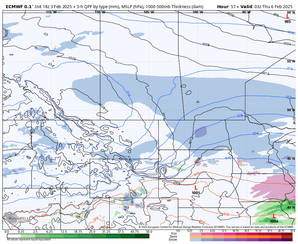
PRECIPITATION TYPE - MAP FROM WEATHERBELL
The first snow bands will push into Southern Ontario from the west by mid-afternoon Saturday, with flurries likely developing east of Lake Huron between 2-4 PM before spreading into the GTA around the dinner hour.
At first, the snowfall will be light, but intensity will gradually increase through the late afternoon and early evening as stronger snow bands move in. Windsor and Chatham could see some mixed precipitation, with a chance of freezing rain or drizzle before switching over to snow.

HOURLY SNOWFALL RATE/intensity - MAP FROM WEATHERBELL
By early evening, snowfall will expand across most of Southern Ontario, bringing steady accumulation.
The heaviest snow is expected west of Lake Ontario, stretching into Kitchener and Goderich, where snowfall rates could reach 1-2 cm per hour.

ESTIMATED WIND GUST - MAP FROM WEATHERBELL
Winds gusting 40-50 km/h along the Lake Erie shoreline Saturday evening may not be extreme, but they could still create minor blowing snow when combined with the steady snowfall, making travel conditions tricky.

HOURLY SNOWFALL RATE/intensity - MAP FROM WEATHERBELL
Snow will continue falling through the evening, gradually spreading toward Eastern Ontario. While Ottawa might see some light snow, accumulation should remain minimal.
The heaviest snow in Eastern Ontario will focus along the Lake Ontario shoreline, including Belleville and Kingston.
As we approach midnight, snow will begin tapering off from west to east, with Lake Huron regions clearing out first. For the GTA, heavier snow may persist a few hours past midnight before gradually weakening.
By early Sunday morning, the system will have moved out of most of Southern Ontario, with only lingering light snow possible in Eastern Ontario.

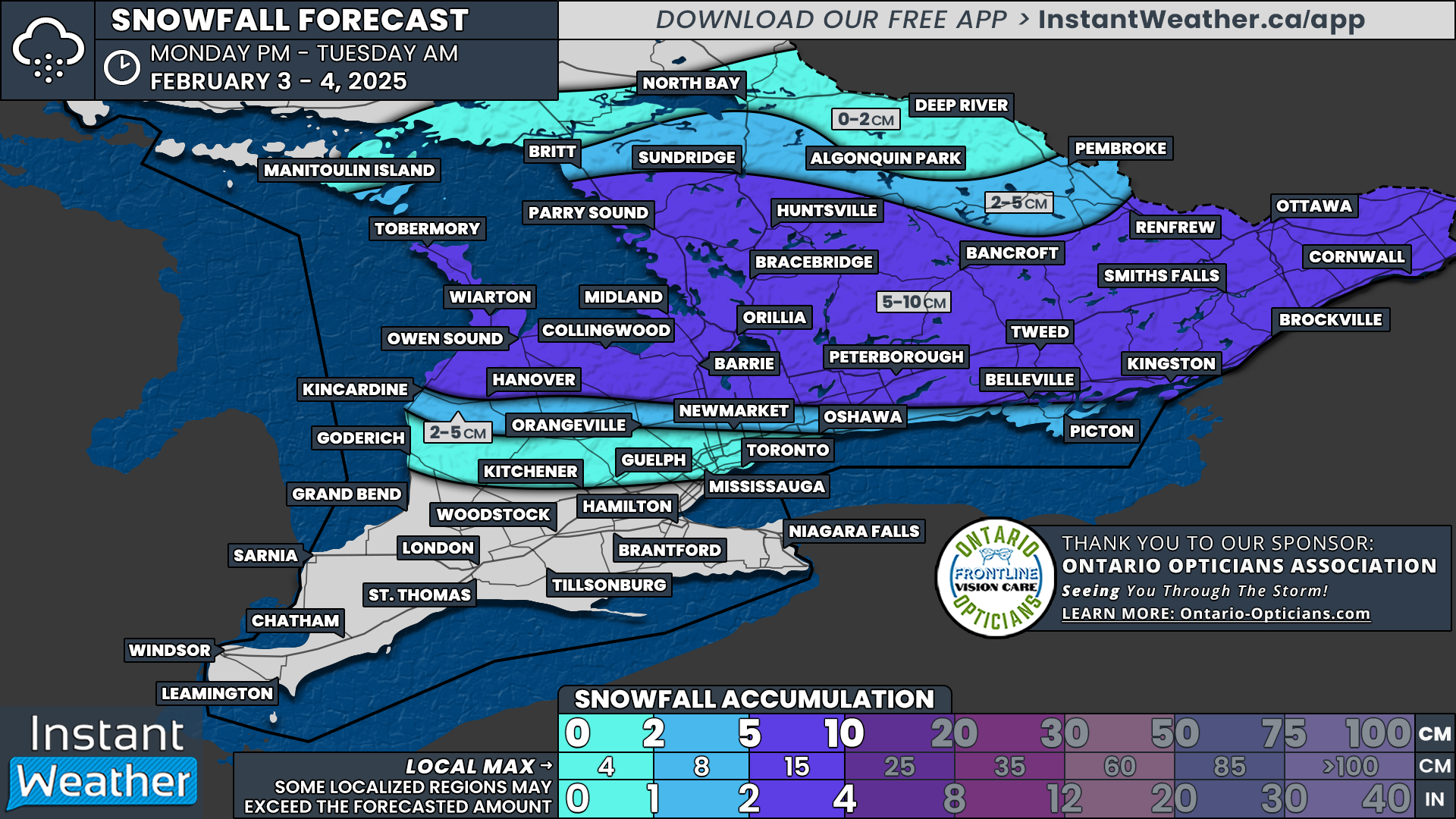
NOTE: YOU CAN CLICK ON THE MAP TO OPEN A ZOOMABLE IMAGE
Recent model trends suggest a stronger system than initially expected, though there remains some uncertainty. Forecasts have bounced between 5-10 cm and 15-25 cm in different model runs.
The current consensus suggests a general 10-15 cm corridor extending from Lake Huron through Kitchener, the Golden Horseshoe, and into the Kingston area, with localized pockets nearing 20 cm.
For areas further north, including Simcoe County, Kawartha Lakes, and Brockville, as well as Sarnia and London, 5-10 cm of snow is expected.
The least snowfall will be in the Ottawa Valley, where less than 5 cm is likely. Deep Southwestern Ontario, including Windsor and Chatham, will see the lowest totals, with 2-5 cm possible, along with the risk of freezing rain.
This will be one of the most widespread snowfalls of the season, especially for regions that have barely seen measurable snow this winter. Stay tuned for further updates as the system approaches.