Much Needed Rainfall is Finally on its Way for Most of Saskatchewan This Weekend

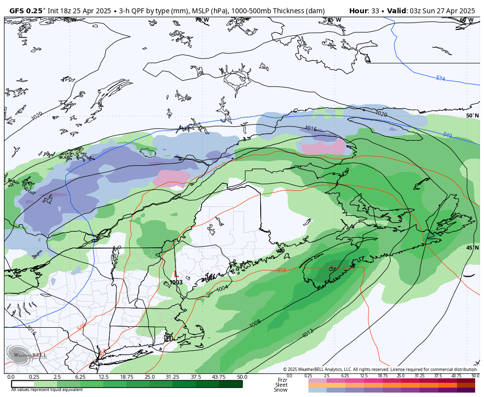
Model image showing total rain from friday morning until monday morning, courtesy of weatherbell

Good news Saskatchewan: there's finally rain in the forecast! The bad news is that not everyone will see the rain and strong winds could still be an issue.

To start, we've already seen some scattered showers across Northern Saskatchewan this morning. The rain is expected to continue through the day and into tomorrow, with some pushing into Central Saskatchewan this evening.

This precipitation will be associated with non-severe thunderstorms, like we've seen for most of the week, which could bring strong wind gusts up to 70km/h and possibly small hail. Luckily though, these storms will finally bring a decent amount of precipitation.

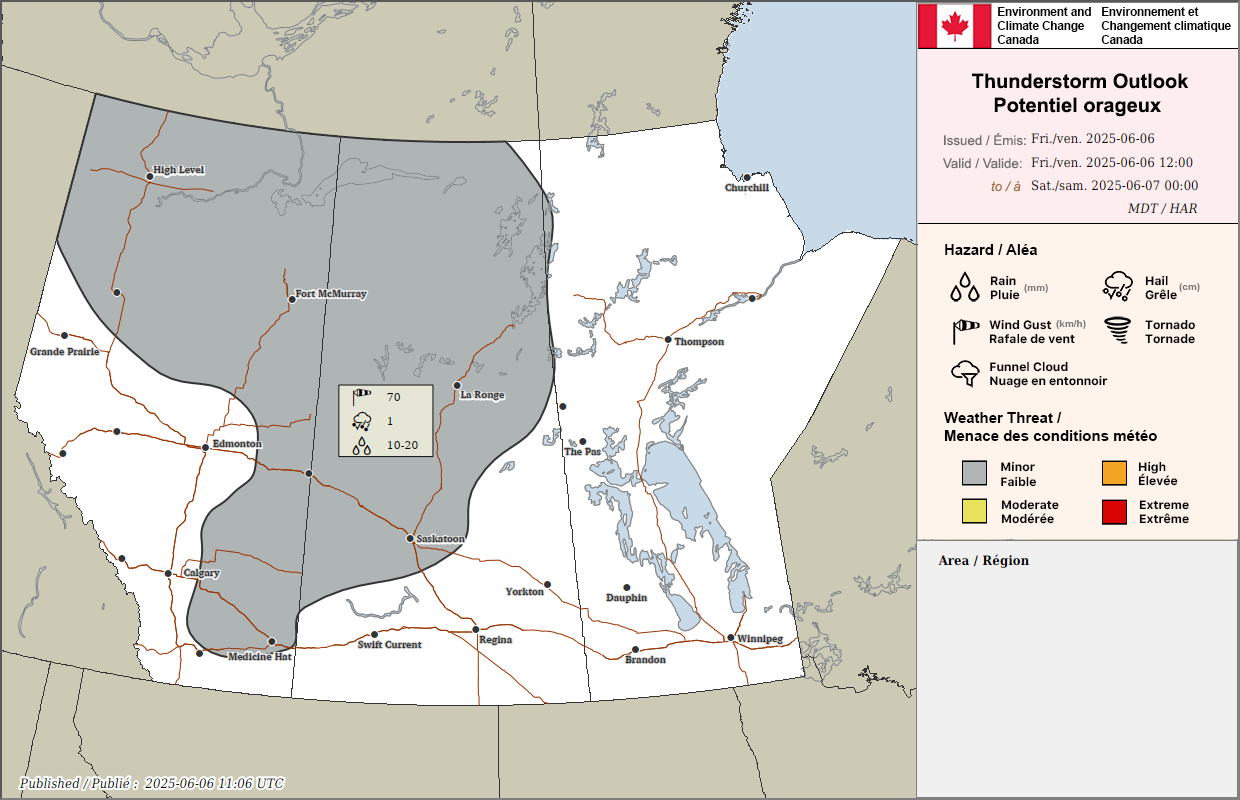
Environment Canada forecast for friday afternoon

Early tomorrow morning, light rain will cross through Southern Saskatchewan. Then, in the afternoon, the rain from the north will push southeastward as it wraps around a low pressure system moving south from the Territories.

The rain is expected to fall in in Eastern Saskatchewan through Sunday morning and afternoon, dissipating in the evening and leading to much less rainfall in the Southwest than in the rest of the province. Aside from this region, widespread 10-50mm is expected by the end of Sunday. Luckily, the areas with the worst fires can expect a decent amount of rain this weekend.

Unfortunately, strong wind gusts up to 70km/h are expected to persist through the weekend and this could still pose a challenge for firefighting efforts despite the precipitation and cooler temperatures.

Warm Temperatures Briefly Return With Isolated Severe Thunderstorm Risk for Southern Ontario Wednesday

NOTE: YOU CAN CLICK ON THE MAP TO OPEN A ZOOMABLE IMAGE

While much of late May across Southern Ontario was dominated by unseasonably cool weather, the start of June is shaping up to be a very different story. Over the past few days, temperatures have rebounded to near-seasonal levels across the region, and that’s just a preview of what’s ahead. But enjoy it while you can because a noticeable cool down is expected later this week.

This early June heat has also arrived with a layer of upper-level smoke drifting in from wildfires burning across Western Canada. This smoke has caused a light haze in the sky, giving the air a faint smoky smell, dimming the sun, and slightly suppressing daytime temperatures compared to what we would have seen under clear skies.

The good news is that much of this smoke is expected to clear out across Southern Ontario overnight into early Wednesday morning. While some lingering smoke may remain high up in the atmosphere, it shouldn’t be as thick or widespread as what we’ve seen over the past 36 hours.

With clearer skies, daytime heating will be more effective, giving temperatures a better shot at reaching their full potential. On Wednesday, we’re expecting highs to climb into the upper 20s and possibly even low 30s in some spots.

NOTE: YOU CAN CLICK ON THE MAP TO OPEN A ZOOMABLE IMAGE

A cold front sweeping across the province late Wednesday will bring a shift in the pattern, knocking temperatures back below seasonal for the latter half of the week. This front is also expected to trigger a line of thunderstorms, some of which may be marginally severe.

Primary threats include damaging wind gusts up to 90 km/h, pockets of quarter-sized hail, and localized flooding from slow-moving storms. There is also a very low risk of an isolated tornado, but given the weak storm environment, this threat is quite uncertain and likely limited.

ESTIMATED AIR TEMPERATURE - MAP FROM WEATHERBELL

Much of Wednesday will start off hot and hazy, especially across Southern Ontario. Temperatures will rapidly climb into the upper 20s by early afternoon ahead of the approaching cold front. In some areas, particularly Deep Southwestern Ontario, the Golden Horseshoe, and the Ottawa Valley, temperatures could push into the low 30s.

That said, locations along the immediate shorelines of the Great Lakes will likely remain a few degrees cooler due to the lake breeze. These areas, including communities along Lake Erie, Lake Ontario, Lake Huron, and Georgian Bay, should see highs closer to the low to mid-20s.

As the cold front begins moving in from the northwest, starting around 2 to 4 PM near the Bruce Peninsula and the North Bay and Parry Sound region, we’ll see an almost instant temperature drop. It could fall by as much as 10 to 15 degrees within a couple of hours. The front will then gradually push southeast through the rest of the afternoon and into the early evening hours.

As the temperatures rise, it’s crucial to keep our beloved pets safe and comfortable. Here are some essential tips to ensure your furry friends stay cool this summer:

🚗 Never Leave in Cars: Even with windows cracked, the temperature inside a car can rise dramatically in just a few minutes. On a 24°C day, the temperature inside a parked car can soar to 38°C in just 10 minutes. In 30 minutes, it can reach 49°C! Leaving your pet in a car can be deadly, so never leave them unattended.

If you see a pet left unattended in a car in Ontario:

  • Look for the Owner: Note the car's make, model, and license plate number. Go to nearby businesses to see if you can find the owner.

  • Call for Help: If you cannot find the owner, call your local animal control or police. You can call the OSPCA at 1-833-9-ANIMAL (264625). If you believe the animal is in immediate distress, call 911 immediately.

  • Stay with the Pet: Remain with the pet until help arrives.

🏡 Shade & Shelter: Make sure your pets have access to shaded areas to avoid direct sunlight. A cool, sheltered spot can make a big difference.

💧 Hydration is Key: Always provide fresh water for your pets. Dehydration can set in quickly, so keep their water bowl filled and in a shaded area.

🐕 Limit Exercise: Avoid walking your pets during the hottest parts of the day. Early morning or late evening walks are best to prevent overheating.

🐾 Paw Protection: Hot pavement can burn your pet's paws. Walk them on grass whenever possible, or use protective booties to shield their feet.

⚠️ Watch for Signs of Overheating: Symptoms include excessive panting, drooling, and lethargy. If you notice these signs, move your pet to a cooler area immediately and provide water.

UPPER LEVEL SMOKE CONCENTRATION - MAP FROM WEATHERBELL

Although the smoke won’t be nearly as thick as what we experienced Monday and Tuesday, some light to moderate upper-level smoke may still linger on Wednesday. Forecast models suggest the highest concentrations will likely be around the Golden Horseshoe, including the Greater Toronto Area, Hamilton, and the Niagara region.

There may still be a faint smoky smell in the air at times, but surface-level smoke isn’t expected to be heavy enough to significantly impact air quality. What it could do, however, is hold temperatures back by a couple of degrees in some spots since the sunlight won’t be able to fully break through the smoke layer.

By Thursday, most of this smoke should clear out completely. That said, some models are hinting at another round of wildfire smoke pushing into the region by late this week or into the weekend.

SIMULATED RADAR - MAP FROM WEATHERBELL

Along with cooler temperatures, the advancing cold front will bring the potential for thunderstorms across Southern Ontario. Current data suggests that a line of storms will begin forming early Wednesday afternoon, stretching from North Bay down into parts of Michigan.

NOTE: YOU CAN CLICK ON THE MAP TO OPEN A ZOOMABLE IMAGE

As this front continues to track southeastward, conditions will become more favourable for some of these storms to become locally severe. Isolated threats include damaging winds, large hail, and heavy downpours. The highest risk zone appears to be in a corridor running from Deep Southwestern Ontario through Kitchener and Waterloo, into the Lake Simcoe region, and extending northeast into the Algonquin Park area.

The timing for the strongest activity looks to fall between 3 PM and 6 PM, though it could stretch a bit later, especially in areas near the border. Some model runs even show a rogue thunderstorm crossing into the Windsor or Sarnia area from Michigan during the evening hours.

The overall tornado threat remains low due to the weak storm environment and expected messy storm mode, but it is never zero. Sometimes we do see surprise spin-up tornadoes in Ontario, especially where lake breezes collide and enhance low-level rotation.

After sunset, the severe risk should wind down fairly quickly. However, a few non-severe thunderstorms may continue into the late evening and overnight as the front moves across the Golden Horseshoe and into Eastern Ontario.

💨 WINDY WEDNESDAY: Environment Canada Forecasting Severe Thunderstorms With 90km/h Wind Gusts, Toonie Sized Hail & 50mm Flooding

NOTE: YOU CAN CLICK ON THE MAP TO OPEN A ZOOMABLE IMAGE

Environment Canada has released its latest Thunderstorm Outlook forecasting a “moderate” (2 out of 4) risk for severe thunderstorms across much of Southern Ontario on Wednesday, June 4th, 2025. They mention the potential for 90km/h damaging wind gusts, up to toonie size hail (2-3cm) and 50mm of rainfall that could bring isolated flooding. Timing looks to be from the afternoon to the evening for the strongest storms. Additionally, they mention a “minor” risk (1 out of 4) for thunderstorm activity on Thursday. We’ll break it down below.


💨 Windy Wednesday

NOTE: YOU CAN CLICK ON THE MAP TO OPEN A ZOOMABLE IMAGE

Wednesday Morning:

The first storms are expected to arrive overnight Tuesday into Wednesday morning. These will mainly affecting portions of northeastern Ontario. This includes areas north of Sault Ste. Marie, stretching around Timmins and Moosonee towards the Quebec border and regions north of Lake Superior. Expect non-severe thunderstorms, with the main concern being isolated lightning strikes. While widespread heavy rain isn't the primary threat here, local rainfall amounts could reach up to 30 mm, with peak hourly rates around 15 mm. Environment Canada indicates a moderate confidence level for these initial storms.


NOTE: YOU CAN CLICK ON THE MAP TO OPEN A ZOOMABLE IMAGE

Wednesday Afternoon and Evening:

The afternoon and evening will bring a risk for severe thunderstorms across much of Southern Ontario. This area could experience isolated storms capable of producing a combination of strong winds, large hail, and heavy rain. Impacts could include damage to plants and crops, and loose objects could be tossed around by the gusty winds. There's also a risk of damage to weaker structures, broken tree branches and even downed trees. With the heavy rain, possible flash flooding and water pooling on roads are also concerns. Rainfall in these stronger storms could locally total up to 50mm, with intense peak hourly rates reaching up to 30mm. It's important to note that areas experiencing several rounds of thunderstorms have the strongest chance of seeing isolated flooding.

Interestingly, Environment Canada adds a caveat for these Southern Ontario storms: while some thunderstorms may indeed produce very gusty winds, hail, and torrential downpours, there's a possibility that smoke aloft might hinder their overall strength. This makes Environment Canada’s confidence of how severe these storms will become lower than normal for this type of setup, despite the potential for “moderate” to “high” impacts.


⛈️ Thunder Thursday

NOTE: YOU CAN CLICK ON THE MAP TO OPEN A ZOOMABLE IMAGE

Thursday:

The likelihood of thunderstorms continues into Thursday across many parts of northern, far northern, and southern Ontario including areas like Windsor, London, Toronto, Hamilton, etc. Non-severe thunderstorms remain possible. Once again, isolated lightning strikes will be the main concern with local rainfall generally expected to be less than 15 mm. Environment Canada has moderate confidence in these storms developing.

NOTE: YOU CAN CLICK ON THE MAP TO OPEN A ZOOMABLE IMAGE

The focus Thursday shifts towards Eastern Ontario, highlighted as 'Area A' on the forecast map above. This area includes Ottawa, Cornwall, Perth, Brockville and areas east of Kingston. Stronger thunderstorms are possible, bringing hazards of strong winds and hail. If these storms strengthen as expected, they could damage plants and crops and toss loose objects. Environment Canada suggests these storms could produce wind gusts from 70-90 km/h and hail up to 2 cm (nickel size). Additionally, local rainfall amounts are expected to be up to 15 mm.


🔎 Staying Safe and Prepared

As we move into summer and a more active weather pattern, it’s critical to stay informed! To keep a close eye on our latest forecasts and get notified of any alerts, download our free app Instant Weather, available on Apple and Android devices.

Remember the golden rule of lightning safety: "When thunder roars, go indoors!" as there is no safe place outside during a thunderstorm. Ahead of the storms, particularly on Wednesday afternoon and evening in Southern Ontario and throughout Thursday in Eastern Ontario, take a moment to secure any loose outdoor items before the storms arrive. Things like patio furniture, trampolines, and garbage cans can become projectiles in strong winds.

If you're planning to be on the roads, be prepared for challenging driving conditions such as sudden downpours, significantly reduced visibility, and the possibility of water pooling on roadways, especially in areas expecting heavier rainfall.

Stay safe everyone and if it’s safe to do so, share your reports with half a million community members on our Facebook group called Ontario Storm Reports!


Disclaimer: These forecasts are issued by Environment Canada and typically published via their Twitter/X accounts. We receive these forecast via a daily email and often publish them to help inform our communities.

Two EF1 Tornadoes Confirmed Northeast of Edmonton From Monday, May 26th, 2025

NOTE: YOU CAN CLICK ON THE IMAGE TO OPEN A ZOOMABLE VERSION

Two EF1 tornadoes have been confirmed in Alberta from May 26th, 2025 by the Northern Tornadoes Project (NTP). Thankfully, there were no injuries with these two tornadoes. The strongest of the two was on the ground for an impressive 21.2km and had estimated wind speeds of 175km/h. The two tornadoes touched down near Lac la Biche and left behind lengthy, narrow paths of damage, including a partially removed roof from a home and numerous snapped and uprooted trees.

Investigators from the NTP conducted thorough ground and drone surveys on May 28th and noted that Alannah and Patricia from our own Instant Weather team helped get their team deployed quickly. The NTP wrote: “Thanks to Alannah and Patricia at Instant Weather for their initial (late-night) alert to the damage, allowing us to get our team out faster!” We at IW are grateful that we were able to help NTP with their investigation and super thankful that no one was injured in these two tornadoes. The NTP meticulously documented the aftermath and their findings paint a clear picture of the two separate twisters that tore through the region.


The Atmore Twister – A Lengthy Path of Damage

NOTE: YOU CAN CLICK ON THE IMAGE TO OPEN A ZOOMABLE VERSION

The first tornado, designated the "Atmore" event, began its destructive journey at approximately 7:00 PM MDT (0100 UTC) on May 26th.

Final EF-Scale Rating: EF1

Estimated Max. Wind Speed: 175 km/h

Track Length: A substantial 21.2 km

Max. Path Width: 300 m

Motion: From the Southwest (approx. 220 degrees)

NOTE: YOU CAN CLICK ON THE IMAGE TO OPEN A ZOOMABLE VERSION

This twister carved a significant path, causing notable damage to homes near Atmore and Rossian (north of Plamondon). Reports detailed structural impacts and the NTP survey confirmed these, along with extensive tree damage. Satellite imagery review also highlighted the visible tree damage along its long, narrow track. Luckily, despite the substantial property damage, no injuries were reported.

NOTE: YOU CAN CLICK ON THE IMAGE TO OPEN A ZOOMABLE VERSION


The Avenir Tornado – A Shorter, Wider Impact

NOTE: YOU CAN CLICK ON THE IMAGE TO OPEN A ZOOMABLE VERSION

Just 25 minutes after the Atmore tornado began, a second EF1, named the "Avenir" event, touched down further to the northeast at approximately 7:25 PM MDT (0125 UTC).

  • Final EF-Scale Rating: EF1

  • Estimated Max. Wind Speed: 150 km/h

  • Track Length: 6.43 km

  • Max. Path Width: A slightly wider 370 m

  • Motion: From the South-Southwest (approx. 205 degrees)

NOTE: YOU CAN CLICK ON THE IMAGE TO OPEN A ZOOMABLE VERSION

While shorter in track length, the Avenir tornado left a clear signature, primarily impacting forested areas near the community of Avenir. Satellite imagery initially revealed its narrow path of tree damage, which was later confirmed and documented by the NTP's ground and drone survey. As with the Atmore event, no injuries were reported in connection with this tornado.

NOTE: YOU CAN CLICK ON THE IMAGE TO OPEN A ZOOMABLE VERSION


Understanding the Findings

The Northern Tornadoes Project plays a crucial role in confirming, classifying and analyzing tornado damage across Canada. Their use of satellite imagery, followed by on-the-ground surveys with drones, allows for precise classification and understanding of these powerful weather phenomena.

These EF1 tornadoes, with wind speeds reaching up to 175 km/h, serve as a reminder of the potential for severe weather in Alberta. While not the most powerful on the Enhanced Fujita (EF) Scale, they are certainly capable of causing significant localized damage, as evidenced by the events near Lac la Biche.

Find out more & get notified

  • You can view precise tracks of these tornadoes and explore other Canadian tornado and downburst events on the interactive NTP Dashboard.

  • Always have a plan for severe weather and download our free app Instant Weather to get notified of any alerts from Environment Canada or any custom updates from the IW team regarding rotation, funnel cloud reports, etc.

Slight Risk for Isolated Severe Thunderstorms on Thursday with 100km/h Wind Gusts, 3cm Hail & Isolated Flooding Possible

NOTE: YOU CAN CLICK ON THE MAP TO OPEN A ZOOMABLE IMAGE

We’re closely monitoring a slight risk for isolated severe thunderstorms this afternoon and evening in parts of central Alberta. Areas such as Edmonton, Edson, Red Deer, Whitecourt, Leduc, Camrose, Rocky Mountain House, Drayton Valley, High Prairie, Slave Lake, Lac la Biche, Westlock, Hinton, Olds and surrounding communities may see these storms. However, as they’ll be isolated, most areas will not receive any precipitation at all.

Damaging wind gusts of 80-100km/h, 3cm hail and isolated flooding up to 50mm are the main risks for these storms. Of course, frequent lightning and torrential rain are also expected for those who are affected by these storms.

The overall tornado risk is low so chances of a spin-up are unlikely. However, we all know that stranger things have happen so definitely make sure to have our free app Instant Weather to get notified of any and all alerts from Environment Canada for your area.

Environment Canada has also issued Severe Thunderstorm Watches for the region, shown below.

NOTE: YOU CAN CLICK ON THE MAP TO OPEN A ZOOMABLE IMAGE

NOTE: YOU CAN CLICK ON THE MAP TO OPEN A ZOOMABLE IMAGE

Environment Canada writes:

”Conditions are favourable for the development of severe thunderstorms this afternoon and evening that may be capable of producing strong wind gusts and large hail.

Damage to roofs, fences, branches or soft shelters is possible. When thunder roars, go indoors! Lightning kills and injures canadians every year.

Severe thunderstorm watches are issued when conditions are favourable for the development of thunderstorms capable of producing damaging hail, wind or rain.”


In addition to the severe thunderstorm risk, the Fire Danger map for Alberta shown below is very concerning as almost all areas of Alberta are under “Extreme” fire danger.

Fire danger map for may 29th produced by the government of Alberta

With the expected lightning, warmer temperatures and drier conditions, it’s very possible we could see new wildfires ignited from these storms today. Please stay safe folks and we’ll post more updates when available.

Slight Risk for Severe Thunderstorms on Monday as a Cold Front Advances Through Alberta

NOTE: YOU CAN CLICK ON THE MAP TO OPEN A ZOOMABLE IMAGE

The past week was fairly quiet, as far as active weather is concerned, with the odd pop-up thunderstorm surpassing the severe threshold and a couple of funnel cloud reports. This week, however, is slated to start off with a bang as a cold front will move into Alberta later this afternoon, stretching the length of the province and triggering the development of thunderstorms over a widespread area.

We’ve already seen some scattered showers across parts of Central and Northern Alberta today, but the severe threat won’t begin until this afternoon, around 2-4pm. These will be fast-moving storms that will quickly develop and organize into a north-south line along the cold front as it crosses the province through the afternoon and evening. Storm activity will rapidly diminish as we get later into the evening, but isolated storms could continue until closer to midnight, if conditions remain favourable.

The greatest thunderstorm risk will stretch from Calgary northward up to Fort McMurray, highlighted in yellow on our map. This large region could see damaging wind gusts of up to 100km/h and large nickel to quarter-sized hail, along with torrential downpours. At this point, the threat of a tornado appears to be unlikely, but it can not be completely ruled out.

Fire danger map for may 26th produced by the government of Alberta

The amount of lightning associated with today’s storms could also be a concern. Warmer temperatures and drier conditions have elevated the wildfire risk over the past week and has led to High to Extreme Wildfire Danger across the entire province. Significant amounts of lightning, despite the presence of precipitation, could easily spark additional fires given these conditions.

Ontario’s First Confirmed Tornado of 2025: EF0 Touches Down Near Woodstock Last Week

NOTE: YOU CAN CLICK ON THE MAP TO OPEN A ZOOMABLE IMAGE

Ontario’s tornado season has officially begun. The first confirmed tornado of 2025 touched down during the early morning hours of May 16th, just south of Lakeside, Ontario, northwest of Woodstock.

The tornado developed along the leading edge of a line of storms that had tracked into the province from Michigan.

While this EF0 tornado near Lakeside was the first confirmed in Ontario this year, it wasn’t the first in Canada.

According to the Northern Tornadoes Project, this brings Canada’s confirmed tornado count for 2025 to five.

The season began with an EF0 tornado in Alberta in early April, followed by an EF1 in Quebec later that month. Just one day before the Lakeside event, two EF0 tornadoes were confirmed in Manitoba on May 15th.

With peak season still ahead, this serves as a timely reminder that severe weather can happen quickly and under conditions that don’t always look extreme on the surface.

Even low-end risks deserve attention, especially when storms arrive at night, when people are less likely to be tuned in.


The Tornado: A Narrow but Confirmed Touchdown Near Lakeside

Survey map for the Lakeside EF0 tornado (source: Northern Tornadoes Project)

According to the Northern Tornadoes Project (NTP), the tornado developed just south of the village of Lakeside, approximately 25 km northwest of Woodstock. It touched down around 3:00 AM EDT, shortly after a squall line of thunderstorms entered the region from the west.

Drone photo of worst damage point featuring multiple snapped conifers (source: Northern Tornadoes Project)

Damage was limited to trees and a power pole, with no injuries reported. The tornado was assessed as an EF0, with estimated maximum wind speeds of 115 km/h. It travelled a distance of 3.6 km, with a maximum path width of 160 metres, moving generally from the west-southwest (255°).

Radar data shows possible rotation near lakeside (source: iw pro)

Radar imagery at the time showed a compact area of low-level rotation, but due to the storm’s embedded structure and the overnight timing, the event went unwitnessed until damage was reported later that day.

The NTP conducted both ground and drone surveys on May 20th to confirm the tornado’s track and intensity.

This information is sourced from the Northern Tornadoes Project’s full report, which can be found here.

Survey map showing the location of the EF0 downburst (black oval) and collected data (source: Northern Tornadoes Project)

In addition to the confirmed tornado near Lakeside, the Northern Tornadoes Project also verified a separate EF0 downburst near Chatham from the same storm system.

The downburst occurred around 2:15 AM EDT, roughly 45 minutes before the tornado, and caused significant damage to several barns, farm buildings, power poles, and trees.

While similar wind damage was reported across parts of Southwestern Ontario—from Windsor to Shrewsbury—only the enhanced damage south of Chatham was surveyed.

Wind speeds were estimated to have peaked at 130 km/h, placing the event at the high end of the EF0 scale. No injuries were reported.


Timeline: Forecast Leading Up to the Tornado

Forecast models began flagging the potential for severe storms several days in advance, particularly in Deep Southwestern Ontario, where the environment appeared favourable for severe weather.

Instant Weather and the U.S. Storm Prediction Center both noted the possibility of tornadoes — albeit marginal — due to the timing and nocturnal nature of the storms. This provided over 24 hours of advance notice about the potential for severe weather.

Despite the lower-end risk, one storm managed to spin up a brief EF0 tornado shortly after 3:00 AM on May 16th.


Instant Weather first highlighted the tornado potential on Wednesday afternoon, referencing the Storm Prediction Center’s forecast and the setup in Michigan and Southwestern Ontario:

The following morning, just under 24 hours before the confirmed tornado, Instant Weather once again flagged the risk.

This time, the post specifically mentioned that a 2% tornado risk extended into Sarnia, Chatham, Grand Bend, and as far northeast as London, placing the affected area firmly within the broader risk zone:

Later Thursday afternoon, a forecast was issued by Instant Weather calling for the potential of isolated tornadoes overnight. The forecast map outlined a marginal risk that included the area near Lakeside, where the tornado would eventually touch down:

Around 1:47 AM, just over an hour before the tornado touched down, Instant Weather sent out a custom notification for the London area, referencing minor rotation and clearly stating that “an isolated tornado cannot be ruled out”:

At 2:55 AM, Environment Canada issued a Severe Thunderstorm Warning, which included a note that severe thunderstorms can produce tornadoes. This came approximately five minutes before the tornado would touch down near Lakeside

Finally, live coverage was underway on Instant Weather’s YouTube channel during the time the tornado developed around 3:00 AM, as the storm moved through Oxford County.

Nocturnal Thunderstorm Threat With Damaging Wind Gusts and Isolated Tornado Risk for Southwestern Ontario Tonight

updated map - 10:50 PM (CLICK HERE FOR THE PREVIOUS MAP)

NOTE: YOU CAN CLICK ON THE MAP TO OPEN A ZOOMABLE IMAGE

UPDATE (10:50 PM):

We’ve been closely tracking the line of storms developing across Michigan, and it’s now set to move into Deep Southwestern Ontario over the next few hours.

Based on the latest model data, current environmental conditions, and how well the storm is holding together despite the lack of daylight heating, we believe there’s enough evidence to upgrade parts of Deep Southwestern Ontario to a ‘strong’ (3/5) risk—mainly due to the potential for intense wind gusts.

Large hail up to the size of toonies is also possible, and we can’t completely rule out an isolated tornado.

We’ve also extended the ‘slight’ (2/5) risk further inland to include areas like Goderich and London, as new data suggests the line could stay fairly strong as it tracks deeper into Southwestern Ontario during the pre-dawn hours. Again, damaging wind gusts remain the primary threat.

The line is expected to cross the border just after midnight, with the severe threat gradually tapering off but still continuing until around 3–4 AM.


ORIGINAL FORECAST

While storm season has had a quiet start in Southern Ontario, things are beginning to ramp up with a late-night storm risk expected between Thursday evening and early Friday morning. A strong line of storms is forecast to form across Michigan late tonight, initially beginning as discrete supercells over parts of Wisconsin and Illinois.

Based on the latest guidance, these storms are expected to organize into a more linear structure as they track eastward, eventually crossing into Southwestern Ontario sometime just after midnight. While they’ll likely lose some of their strength after dark, especially without daytime heating, the atmosphere may still be supportive enough for them to maintain some intensity as they move into our region.

That said, there’s still a fair amount of uncertainty about just how strong this line will be once it crosses the border, and how quickly it might weaken as it tracks northeast through the early morning hours of Friday.

The biggest concern with this system is the potential for damaging wind gusts. This squall line will stretch from the Upper Peninsula of Michigan all the way down through Ohio as it enters Ontario, which could lead to widespread impacts. Areas from the Bruce Peninsula all the way down to Deep Southwestern Ontario are at risk of strong winds embedded within the line.

The highest risk appears to be in Deep Southwestern Ontario, where the line will first cross into Ontario. Regions like Windsor, Leamington, Chatham, and Sarnia are most likely to experience the strongest part of this line. While damaging wind gusts are the main hazard, we also can’t completely rule out the chance for hail and even a brief tornado, especially if the storms arrive a bit earlier than forecast.

Hail up to the size of quarters is possible, and while the tornado risk is considered low overall, it does exist. The biggest concern here is that this is a nocturnal threat. If a tornado were to develop overnight, it would be harder to spot and could be rain-wrapped, making it even more dangerous. That’s why it’s so important to stay alert and have a way to receive warnings while you sleep.

SIMULATED RADAR - MAP FROM WEATHERBELL

Storm development will begin with discrete cells over Wisconsin and Illinois, likely forming into a long line around 8–10 PM near Chicago and across Lake Michigan.

The timing of this formation is crucial. If the line develops sooner and sweeps across Michigan quickly, it could result in a more robust severe risk for Deep Southwestern Ontario, where the environment is more favourable before midnight.

No matter the timing, damaging winds remain the most likely outcome with this type of linear storm setup.

SIMULATED RADAR - MAP FROM WEATHERBELL

As of now, future radar models suggest the storms will cross into Ontario between 1 and 2 AM, hitting areas like Windsor and Sarnia first before stretching further northeast. However, there’s still wiggle room in this timing. It could arrive earlier and stronger, or later and already weakening before reaching our region.

ESTIMATED TORNADO ENVIRONMENT - MAP FROM WEATHERBELL

While widespread wind damage is the primary concern tonight, there is some minor tornado potential—especially in Essex County just after midnight. Again, the odds are low, but not zero.

Because of the overnight timing, it's extra important to have notifications enabled on your phone or weather radio. Make sure you have a way to receive alerts while you're asleep in case a warning is issued. Our free app is a great way to instantly get Environment Canada alerts, along with our custom notifications issued for your exact location.

SIMULATED RADAR - MAP FROM WEATHERBELL

The line of storms is expected to continue northeast through the early morning hours, bringing heavy rain, gusty winds, and frequent lightning to much of Southwestern Ontario and parts of the Greater Toronto Area between 3 and 6 AM.

While the line should gradually weaken during this time, it could still pack a punch in some localized areas. There’s some uncertainty around how long it will be able to hold its strength since the atmospheric environment in Ontario is notably weaker than what the storms had access to in the U.S.

Latest model runs show the system likely fizzles out once it reaches Lake Simcoe, meaning Eastern and Central Ontario probably won’t see much beyond a few scattered morning showers or storms.

Another round of storms is possible Friday afternoon and evening, particularly for Eastern Ontario and parts of Deep Southwestern Ontario. We’ll have more details on that in a separate update.

As it stands, the highest storm risk tonight is in Deep Southwestern Ontario, where we currently have a slight risk (2/5) for severe weather. The main hazard is damaging wind gusts between 12 and 6 AM, though isolated tornadoes and hail up to the size of quarters are also possible.

For the rest of Southwestern Ontario and the Golden Horseshoe, the risk is lower—a marginal (1/5) severe threat—with isolated pockets of wind damage being the most likely outcome. There’s also a very low tornado risk along the Lake Huron shoreline as the line initially pushes into the region. Hail up to the size of nickels could accompany some of these storms.

In addition to the overnight threat, a few isolated pop-up storms are possible during the late afternoon and early evening across parts of Grey-Bruce. While these are not expected to be severe, funnel clouds are possible, including a low-end risk of a landspout tornado. See our custom notification for more on the funnel cloud setup.

Stay weather-aware tonight. Keep your devices charged, notifications turned on, and have a plan in place just in case you need to take shelter quickly. We’ll continue to monitor the latest data and provide updates as the situation evolves, including a possible live stream later tonight.

Up to 75mm of Rain for Parts of Southern Saskatchewan & Manitoba, Along with Worsening Air Quality, Expected to End the Work Week

NOTE: YOU CAN CLICK ON THE MAP TO OPEN A ZOOMABLE IMAGE

It is certainly shaping up to be a roller coaster of a week, weather-wise, across Saskatchewan and Manitoba. The week began with record-breaking heat and relentless winds, which made things feel exceptionally dry and were the catalyst for the spread of multiple wildfires across both provinces. Now, cool Arctic air has flooded south and a low pressure system is pushing its way northward from the Dakotas, which will bring significant rain to parts of Southern Saskatchewan and Manitoba on Thursday and Friday.

Pockets of rain on the leading edge of this system have been pushing northward into Southeast Saskatchewan and Westman already Wednesday evening. This will be followed by a large area of steady, heavier rain moving into this region shortly after midnight and continuing through most of the day Thursday.

The rain will gradually spread further northward Thursday morning and by the afternoon, it should also start to cross the border into the rest of Southern Manitoba. This delay in the start of the precipitation will lead to slightly less rain falling overall, but it’ll be fairly steady for the remainder of the event so a widespread 25-50mm can be expected.

In Southeast Saskatchewan and Westman, the earlier start to the precipitation will lead to this area receiving upwards of 75mm of rain. Considering this region already received a fair bit of rain Wednesday morning, this much additional rainfall could very easily lead to some localized flooding.

The center of this system will stay south of the border and will start making its way eastward early Friday morning. The rain will start to taper off, from west to east, beginning Friday morning, before it completely exits the region Saturday morning.

As far as the wildfire situation is concerned, this rain will definitely help containment and suppression efforts in some areas, but it likely won’t be enough to completely douse the flames. In Southeast Manitoba, where several out-of-control fires are burning as of Wednesday evening, 10-25mm is expected to fall with this system, which will be welcomed support.

In Saskatchewan though, the rain will unfortunately not push deep enough into the province to impact the fires that have been burning near Narrow Hills Provincial Park, to the north of Nipawin, so hopefully the cooler temperatures will be enough to help crews in this area.

The arrival of this low pressure system will also have a negative impact, mostly in Southern Manitoba, but also in Western Saskatchewan. As the low approaches, the wind direction will shift, causing wildfire smoke to start moving westward in Manitoba and southward through Saskatchewan.

But why does this happen? To explain, we need to dig a bit deeper into the science of meteorology.

Modelled low-level Wildfire Smoke Concentration at 12pm CT on Thursday, May 15th. Note: this particular model only extends so far into Canada, but it shows the movement of smoke in both Manitoba and Saskatchewan.

One of the fundamental rules in meteorology is that air will always want to flow from areas of high pressure to areas of low pressure. This is actually the main driver behind wind.

Air doesn’t take a straight path from high pressure to low pressure, though. Thanks to the Coriolis Effect, caused by the spinning of the planet, air travels towards a low pressure center in a more counter-clockwise fashion, as shown below.

diagram showing how air moves around both high pressure and low pressure centers, courtesy of NOAA.

Putting this all together, as the low pressure center gets closer to us, air will naturally travel towards it and this will pull the wildfire smoke along with it. With where the low will be positioned over North Dakota, this means that smoke will travel westward from the fires burning in Southeast Manitoba and Northwestern Ontario and southward from the fires in Northern Saskatchewan.

This is expected to begin early Thursday morning in Manitoba and after sunrise in Saskatchewan, continuing through the day. On Friday morning, as the low pressure center begins its trek eastward, the wind will start to shift direction. This will be much more noticeable in Manitoba, being closer to the low, with the smoke travelling southwestard during Friday morning and then southward by the afternoon.

Given the number of nearby active fires and their sizes, especially the Nopiming Fire, there is already more smoke in the air in Southern Manitoba than in Northern Saskatchewan. This means that greater concentrations of smoke will move into Winnipeg and the Interlake Region on Thursday and it will diffuse along its path southwestward as it curves towards the low. Then, as the winds shift direction, the thickest smoke will still be found closest to the fires and becoming more diffuse the further away.

In Saskatchewan, the smoke from the two fires near Narrow Hills Provincial Park will travel south-southwestward, into Prince Albert and Saskatoon. Given the distance from the low pressure center, the wind shift is expected to be minimal on Friday.

If the wildfire smoke moves into your area, especially at higher concentrations, try to limit your time spent outside, if possible. We certainly hope that with the arrival of the cooler air and the rain in some areas, that firefighter crews will be able to make considerable progress battling these fires and we will soon have some reprieve from the smoke.

Last Day of Heat Wave for Most of Southern Manitoba on Tuesday Ahead of Major Cool Down

NOTE: YOU CAN CLICK ON THE MAP TO OPEN A ZOOMABLE IMAGE

We have one final day of extreme heat ahead for most of us in Southern Manitoba on Tuesday as once again, temperatures are expected to climb as high as 37°C.

There is some relief on the way for the region, though, with cool air expected to start pushing southward Tuesday evening and bringing single digit overnight low temperatures to almost the entire province. This might not be quite enough to cancel the Extreme Heat Warning for all of Southeast Manitoba. This area could still see temperatures in the low 30s on Wednesday, particularly around Steinbach and eastward.

This cool down will bring single digit high temperatures back to much of Southern Manitoba later in the week and overnight Friday, temperatures could even dip below the freezing mark. With a low pressure system developing over the region to end the week, we could even see the return of some mixed precipitation with these subzero temperatures. It will definitely be a case of weather whiplash this week!

Modelled Temperatures (in °C) at 4AM ct on Saturday

First Slight Severe Thunderstorm Risk of the Year for the Prairies Monday Afternoon Through Tuesday Morning

NOTE: YOU CAN CLICK ON THE MAP TO OPEN A ZOOMABLE IMAGE

While we saw some severe storms eventually develop in Southeast Saskatchewan and Southwest Manitoba yesterday, the severe threat for today and into the overnight hours is heightened, resulting in our first Slight Risk of the season.

We’ve already seen heavy rain falling in parts of Central and Southern Alberta today, but thunderstorms have begun to develop and will continue as we progress later through the afternoon and into the evening At this point, it’s possible that these storms may become severe, with the main threat being strong wind gusts and heavy rain. The environment today is also conducive for the development of landspout (non-supercell) tornadoes around Calgary and to the east of the city so we will be watching this situation closely.

It’s further east, in Southern and Central Saskatchewan and Manitoba, that we’re seeing the greatest severe thunderstorm threat. Isolated storms are expected to start developing in the early evening, around 5-6pm and possibly a bit sooner in the afternoon, and models are once again suggesting that the environment could be favourable for the development of supercells.

A bit later in the evening, closer to 7-8pm, we could see some additional storm development in Southwest Saskatchewan as a multicellular line. This complex of storms would travel northeastward across the province and move into Central Manitoba in the early morning hours of Tuesday. It’s during these early morning hours that we could also see more isolated storms develop in Southwest Manitoba.

Large hail, damaging winds, and torrential downpours are all concerns with today’s storms. The possibility of tornadoes is low, but the development of one or two can not be completely ruled out.

Second Day of Temperatures Above 30°C Will Continue to Bake Southern Saskatchewan & Manitoba

NOTE: YOU CAN CLICK ON THE MAP TO OPEN A ZOOMABLE IMAGE

Monday will mark the second day of our heatwave in Southern Saskatchewan and Manitoba. We will once again have a large area expecting temperatures above 30°C, and above 35°C temperatures are possible in a small pocket of Southern Manitoba that includes Winnipeg. Extreme Heat Warnings remain in place from Environment Canada for parts of Southern Manitoba for daytime highs up to the mid 30s and overnight lows only dropping down to the mid teens.

With extreme heat, it’s important to limit strenuous outdoor activities, if possible, or take multiple breaks and drink water often to protect yourself from heat exhaustion and stroke. Early signs of heat exhaustion include: headache, nausea, dizziness, thirst, dark urine and intense fatigue. In the presence of these symptoms, stop all activities and hydrate. Heat stroke, on the other hand, is much more serious. Heat stroke is most identified by confusion and loss of consciousness so make sure to seek immediate medical condition if someone is showing these symptoms.

Marginal Risk for Thunderstorms in Southern Saskatchewan and Manitoba Beginning Sunday Evening

NOTE: YOU CAN CLICK ON THE MAP TO OPEN A ZOOMABLE IMAGE

With the arrival of the first heat wave of the year to Southern Saskatchewan and Manitoba this weekend, we’re also looking at our first real threat of severe thunderstorms for the season.

Isolated storms are expected to develop along the American border in both Saskatchewan and Manitoba this evening, starting around 5-7pm. The storms will travel northeastward into both provinces throughout the evening and into the overnight hours.

Models are suggesting that the environment could be favourable for the development of supercells, but further analysis puts the development of severe storms in question and storms could remain sub-severe. One particular area of interest for possible severe storm development will be in Southeastern Saskatchewan and through the Westman and Interlake Regions.

If severe storms end up developing this evening, the overall threats are expected to be limited. These storms could produce small hail and strong wind gusts, while the possibility of a tornado is unlikely.

First Heat Wave of the Season Will Bring Three Days of Record Breaking Temperatures to Southern Manitoba

NOTE: YOU CAN CLICK ON THE MAP TO OPEN A ZOOMABLE IMAGE

There is a low has that been passing through the Prairies over the past couple of days, which will cross into Manitoba overnight Saturday. It will set up over the region for several days, drawing in hot air from the south. This will lead to an extended period with daytime highs in in the low to mid 30s and overnight lows in the mid teens, triggering Extreme Heat Warnings already being issued by Environment Canada.

With extreme heat, it’s important to limit strenuous outdoor activities, if possible, or take multiple breaks and drink water often to protect yourself from heat exhaustion and stroke. Early signs of heat exhaustion include: headache, nausea, dizziness, thirst, dark urine and intense fatigue. In the presence of these symptoms, stop all activities and hydrate. Heat stroke, on the other hand, is much more serious. Heat stroke is most identified by confusion and loss of consciousness so make sure to seek immediate medical condition if someone is showing these symptoms.

First Strong Severe Thunderstorm Risk of the Season in Southern Ontario on Tuesday With Tornadoes Possible

NOTE: YOU CAN CLICK ON THE MAP TO OPEN A ZOOMABLE IMAGE

After a gruelling winter filled with relentless snow squalls, powerful winter storms, and a major ice storm to top it all off, we are finally shifting gears into more typical spring and summer-like weather across Southern Ontario. But with the warmer air comes the return of severe thunderstorms, something Southwestern Ontario has already gotten a small taste of over the past few weeks.

We have been closely tracking the potential for our first strong severe weather threat of the season on Tuesday. Model guidance has been consistently highlighting the potential for a very active environment, one capable of supporting tornadoes, large hail, and damaging wind gusts. That risk still looks to be on track, although there remains some disagreement between models on exactly where the strongest environment will set up.

At this time, we believe the strongest severe weather risk will focus across parts of Southwestern Ontario, Central Ontario, and into Eastern Ontario. Other areas across Southern Ontario will still carry a marginal to slight risk, meaning a few severe storms could pop up, but the widespread threat will be lower outside the main zone.

Tuesday’s possible storm threats include one or two tornadoes, large hail — potentially up to the size of toonies or even timbits — widespread damaging wind gusts over 90-100 km/h, and heavy rainfall that could cause localized flooding in some spots.

The storm risk will kick off early Tuesday morning as an area of convection moves across the region between 6:00 a.m. and 12:00 p.m. Most of these morning storms should remain non-severe, but we can't rule out a rogue severe cell, especially in setups like this. Where these morning storms track and how quickly they clear out will be important to watch, as leftover clouds or rain could limit how unstable the atmosphere becomes later in the day.

By the early afternoon hours, the environment is expected to rapidly become more favorable for severe weather. Areas along the Lake Huron shoreline will likely be the first to feel the effects, with the risk then spreading into parts of Central Ontario.

Even though we are confident that the setup is capable of producing severe storms, it’s important to stress that storms actually have to form to take advantage of the environment. Not everyone in the higher-risk zone will necessarily see a storm. These will be isolated events, meaning only a small percentage of the region will be directly impacted.

The highest tornado risk will likely occur earlier in the day across Southwestern and Central Ontario, when individual storms (known as discrete supercells) can remain separated and feed off the prime environment around them.

As the afternoon progresses and storms track further eastward, we expect that they will start to merge into more of a line, which would shift the threat more towards damaging winds and heavy rain rather than tornadoes and large hail.

By late afternoon into early evening, the severe weather risk will push eastward into the Golden Horseshoe and Eastern Ontario. The good news is that the risk should wind down quickly after sunset, which occurs around 8:00 p.m.

There could still be some leftover showers or weak storms lingering into the evening, especially across Eastern Ontario, but the threat for damaging weather will rapidly diminish once the sun goes down.

We’ll continue to monitor this setup closely and provide updates as new data becomes available. Stay tuned, and as always, make sure you have a way to receive alerts if storms develop in your area.

Download our free app to instantly get any Environment Canada alerts and our own custom notifications pushed to your phone. We are planning to go live to cover any storms that develop throughout the day on Tuesday. Please subscribe to our YouTube channel here so you can be notified when we go live.

REGIONAL BREAKDOWN

🌪️ ‘Tornado Tuesday’: Confidence Continues to Build For Significant Severe Thunderstorms Next Week in Ontario ⛈️

NOTE: YOU CAN CLICK ON THE MAP TO OPEN A ZOOMABLE IMAGE

TUESDAY, APRIL 29, 2025: Confidence continues to build for the risk of significant severe thunderstorms and tornado activity this Tuesday. Since our first article posted on Friday morning where we discussed this potential, we’ve continued to carefully monitor a strengthening trend on the forecast models. And at this point, we’re trending up from what initially looked like an Enhanced Risk (3/5), towards an isolated Significant Risk (4/5) based on the latest data. What we’re expecting at this point is isolated strong-to-significant severe thunderstorms across parts of Southwestern and Central Ontario Tuesday afternoon & evening that could possibly extend into the GTHA and parts of Eastern Ontario overnight, depending on the timing and speed of the cold front.

A lot can still change four days out but the consistency of the model data is why we here at InstantWeather have been discussing this for several days and why even Environment Canada has issued a preliminary forecast map today, discussing some of the risks on Tuesday including 100km/h damaging wind gusts and 2-4cm hail as you can see in the image below.

NOTE: YOU CAN CLICK ON THE MAP TO OPEN A ZOOMABLE IMAGE

Environment Canada, in their first forecast map for this event has not mentioned a tornado risk. This is likely because we’re four days out but based on the data that we’ll be reviewing below, we’d be very surprised if they did not add a tornado risk in their forecast update tomorrow. Along with this forecast map, they wrote:

”A cold front will track east across northeastern and southern Ontario. By the afternoon, severe thunderstorms may develop with the main threats being strong wind gusts and large hail.”


🔎Model Data Review

NOTE: YOU CAN CLICK ON THE MAP TO OPEN A ZOOMABLE IMAGE

In the image above, we’re looking at the latest “NAM” model data for 5pm on Tuesday and what we’re reviewing is the “Supercell Index”. This gives us an idea of how potent the environment is for rotating storms, which can lead to damaging wind gusts, large hail, flooding, intense lightning and in some cases, tornadoes. In our previous article, we only saw an orange supercell risk which is roughly an “Enhanced” risk level (3/5). However, in the latest data we are now seeing the colour red, which is hinting at the potential for a “Significant” risk level (4/5).

And in the image below, we see what the “Supercell Index” looks like at 8pm from the same “NAM” model, continuing the strong environment into the evening hours and extending it further into Eastern Ontario.


NOTE: YOU CAN CLICK ON THE MAP TO OPEN A ZOOMABLE IMAGE

It’s still quite early but we’re now finally getting some higher quality data from the NAM model at 12km resolution and what you’re seeing above is simulated or “Future Radar” of how the event might play out. It’s still quite early and this could certainly change but it’s interesting to watch it evolve day-by-day. With this model run, the storms start to develop on the Lake Huron shoreline near the Kincardine and Goderich areas around 5pm. We do see some development up by Britt as well around that time. Again, this is just estimated and we could see a new solution to how this plays out each and every day leading up to Tuesday.


NOTE: YOU CAN CLICK ON THE MAP TO OPEN A ZOOMABLE IMAGE

By 8pm in the image above, the simulated NAM future radar is suggesting we could see several potent supercells tracking through parts of Southwestern and Central Ontario. In previous model runs, we have seen a large line of storms as well, which in some cases can limit the tornado risk. Although, we could end up dealing with multi-cell supercells with an environment this strong and those can most certainly produce strong, isolated tornadoes.


NOTE: YOU CAN CLICK ON THE MAP TO OPEN A ZOOMABLE IMAGE

And in this potential scenario from the NAM model, we still the storms expanding and tracking through deep Southwestern Ontario, Central Ontario and perhaps into parts of Eastern Ontario by 11pm. Typically, the later in the evening we get, the less we daytime heating we have to increase the severity of these storms but with how strong this environment is, it could be a late night for many of us and we’ll certainly be livestreaming as long as it takes to ensure everyone stays informed and safe.

If you’d like to get notified when we start livestreaming, subscribe to our YouTube channel for free and hit the bell icon to get notified when we go live.

And to get notified of any rotation detected, funnel cloud reports, tornado reports and Environment Canada watches & warnings, download our free mobile app InstantWeather on your phone or tablet.


🤔Final Thoughts:

If this trend continues and this system does not decide to weaken all of the sudden (here’s hoping it does), Tuesday continues to look like a strong or potentially significant severe thunderstorm risk. All modes of severe weather could be on the table with damaging wind gusts, torrential rain, isolated flooding, large hail, intense lightning and the potential for isolated tornadoes, some of which could be strong. Here’s hoping that it weakens into a marginal risk or vanishes all together!

Having said that, please begin to review your storm safety plan and start discussing the potential for rescheduling your Tuesday afternoon/evening plans.

More details ASAP.


Disclaimer: By using our services and any associated content, this means you implicitly agree to use the services and data available as is with no warranty issued or implied and should be used for informational purposes only. Any use of this data for decision making processes is done at the sole risk of the end user. Do not reproduce or disseminate our forecasts and content without explicit consent of Instant Weather, Inc.

Soggy Last Weekend of April Will Bring Over 50mm of Rain to Parts of the Maritimes

NOTE: YOU CAN CLICK ON THE MAP TO OPEN A ZOOMABLE IMAGE

As we come close to the end of the month, the April Showers will hit in full force this weekend, with at least 20mm of rain expected across the Maritimes by the end of Monday.

Light rain will start to push into New Brunswick from the west in the early morning hours of Saturday, tracking from southwest to northeast. This will be a brief first round of rain that will cross through New Brunswick and into PEI during the morning. In Northern New Brunswick, the cool air could result in some brief light snow falling during the morning, but we’re not expecting much accumulation and it will melt with rain that will follow.

The Annapolis Valley and Cumberland County could see a bit of rain along the southern edge of this initial band as it crosses the region, however, the majority of the rain will come in the following round.

Model Image showing the location and intensity of snow (Blue) and Rain (Green) at 3AM AT Saturday

Not far behind the initial round, the main band of more widespread rain will make its way into the region beginning late Saturday morning. The rain will be very heavy at times as it crosses through the Maritimes for the remainder of the day and into Sunday afternoon.

In New Brunswick, the rain will be heavy during the afternoon and evening before becoming lighter later in the evening and ending overnight. Prince Edward Island can expect the heavier rain to begin in the evening, which will persist into Sunday morning before it tapers off in the early afternoon.

Nova Scotia will see the heaviest rain for an extended period of time with this system. The rain will intensify in Western Nova Scotia starting early Saturday evening and it will spread eastward across the province throughout the evening. It will continue overnight and for most of Sunday morning. It will start to taper off from west to east in the mid-morning, but some areas, particularly along the Atlantic Coast, can expect to see steady rainfall continue into the evening, leading to over 50mm falling.

Model Image showing the location and intensity of snow (Blue), freezing rain (Pink), and Rain (Green) at 12AM aT Sunday

Mid-Sunday morning will see the return of some scattered showers across New Brunswick, which will reach PEI in the late afternoon and continue into early Monday morning. This final lingering band of light rain will push southeastward into Nova Scotia around sunrise Monday and will gradually dissipate in the afternoon and evening.

The entirety of the Maritimes can expect at least 20mm and a widespread 30-50mm is forecast for the region. In Western Nova Scotia, along the Atlantic Coast and into Cape Breton, the heaviest rain is expected, with periods of downpours, which will result in over 50mm of rain and even up to 75mm. If a downpour happens to settle over a particular area for a longer period, closer to 90mm of rainfall is not out of the question.

Strong wind gusts will accompany the rain, reaching up to 60km/h across much of the region Saturday night and Sunday morning. The winds will be stronger in parts of Nova Scotia, especially along the Atlantic Coast and through the Highlands, where gusts could exceed 70km/h, while gusts up to 100km/h are likely in northwestern Cape Breton.

Hopefully with all this rain and some warmer temperatures to end the month, we’ll see plenty of May Flowers!

🌪️ ‘Tornado Tuesday’ Might Make a Return in Southern Ontario Next Week ⛈️

NOTE: YOU CAN CLICK ON THE MAP TO OPEN A ZOOMABLE IMAGE

TUESDAY, APRIL 29, 2025: As I write this discussion (2am on Friday, April 25th, 2025), we’re quite a few days away from Tuesday, April 29th, 2025. Having said that, I’ve been carefully monitoring this strengthening trend on the forecast models for several days now and seeing them consistently suggesting an enhanced risk (3/5) for severe thunderstorms across much of Southern Ontario with the potential for isolated tornado activity. From Windsor, up through Barrie and perhaps even reaching parts of Eastern Ontario and the GTHA.

Typically, five days out is a lifetime for forecasting severe weather. Having said that, in rare circumstances you can see these strong environments coming from a mile away and this looks like this could be one of those events. Especially when we have a lot of data supporting the risk, which we’ll discuss further down the page.

Could this all change? You betcha. After more than a decade of forecasting severe weather in Ontario and across Canada, I’m no stranger to the potential for a “bust”. I could write this article and the entire system could vanish from the weather models. Tuesday could end up being just another typical spring day. Here’s hoping that’s the case. If, however, that is not the case and the trends we’re seeing in the models are correct, this is the type of event that requires getting the word out well in advance so that alternative plans can be considered and you can review your safety plan with your loved ones.

FRIDAY, APRIL 25, 2025: I should probably mention that we will have a risk for isolated thunderstorms today (Friday) and there is a marginal (low) risk for severe storms in deep southwestern Ontario later this afternoon and into the evening hours. Briefly severe hail and strong wind gusts are possible. At this point, it doesn’t look particularly intense but we’ll be keeping a close eye on it, nonetheless.


🔎Reviewing Models & Available Data For Tuesday

NOTE: YOU CAN CLICK ON THE MAP TO OPEN A ZOOMABLE IMAGE

Typically, we like to compare the data from several different model systems. In this case, we’ll compare the American model, the European model and our own Canadian model. In the image above, we’re looking at the American model and what we’re reviewing is the severe weather “energy” that the storms are going to have available to them. The highest levels reaching almost 2,500 (in yellow/orange), which puts this event in the ‘Enhanced 3/5’ category, in my personal opinion.

For context, we can have marginal severe weather with energy levels as low as 500. And on the high-end, CAPE can reach as high as 5,000+ in the most extreme cases. So we’re somewhere in the middle, with totals potentially reaching greater than 1,000 and less than 3,000, at least, at this point.

NOTE: YOU CAN CLICK ON THE MAP TO OPEN A ZOOMABLE IMAGE

Above is the Euro model, showing similar strong values to the American model in the deep southwest at 2pm. But, as you’ll see below, the energy progresses further east as we approach 5pm on Tuesday.


NOTE: YOU CAN CLICK ON THE MAP TO OPEN A ZOOMABLE IMAGE

Above, we’ve got the 5pm timeframe from the Euro model. Showing organized energy values in place for the expected thunderstorms in the afternoon and evening hours.


NOTE: YOU CAN CLICK ON THE MAP TO OPEN A ZOOMABLE IMAGE

While we’re taking a look at the European model, one interesting product they have is an estimated lightning density over several hours. As you can see in red, orange yellow and blue, quite a lot of thunderstorms are expected throughout the afternoon and into the evening hours, taking advantage of all that storm energy we discussed previously.


Below, let’s take a look at the Canadian energy for Tuesday. For some reason, the data looks really blocky. Not sure why PivotalWeather.com (the model provider we’re using for these images) is processing the Canadian model this way but perhaps, it’s coming that way directly from Environment Canada.

Regardless, a similar trend is showing up on the Canadian model that we’re seeing on both the European and American models. And with that, we have what is considered “model agreement”. And it’s not just these three models, other forecasting products called ‘Ensembles’ have 30+ model members and the vast majority are showing a strong severe thunderstorm risk for Tuesday.


NOTE: YOU CAN CLICK ON THE MAP TO OPEN A ZOOMABLE IMAGE

This Canadian model image above is for 2pm on Tuesday. And similar to the European model data where we showed two separate timestamps (2pm and 5pm), this energy will push east, through the Barrie area and potentially into the GTHA and parts of Eastern Ontario through the afternoon and evening hours. Energy values look similar to the other two models, supporting the potential for an Enhanced Risk of severe thunderstorms.


Some other data worth noting in the image below is from the Storm Prediction Center (SPC) in Norman, Oklahoma. Not surprisingly, they are already showing a risk map for Tuesday, which they typically only show this far out when there is a strong system expected and a lot of agreement within the weather models.

You can see that southwestern Ontario gets highlighted in this risk area from Windsor, through Chatham-Kent and Sarnia, cutting off just shy of London. Having said that, the SPC’s only job is to forecast for the US. And as we’ve seen historically with them over the past decade, if they’re showing an extended range forecast that highlights parts of Southern Ontario, we could be in for quite the storm system much further into the Province than is shown below.

NOTE: YOU CAN CLICK ON THE MAP TO OPEN A ZOOMABLE IMAGE


And in the final image below, we’re looking at a Machine Learning (AI) based severe weather estimation from the US. In this case, they cut off the data at the international border but by simply using your imagination, it’s clear that Southern Ontario is included in this risk region.

NOTE: YOU CAN CLICK ON THE MAP TO OPEN A ZOOMABLE IMAGE


🤔Final Thoughts:

If these trends continue and this system does not decide to vanish from all the models suddenly (here’s hoping it does), Tuesday is shaping up to be a strong or potentially significant severe thunderstorm risk. All modes of severe weather could be on the table with damaging wind gusts, torrential rain, isolated flooding, large hail, intense lightning and the potential for isolated tornadoes, some of which could be strong. Here’s hoping that it weakens into a marginal risk or vanishes all together!

Having said that, now would be a good time to start reviewing your storm safety plan and discussing your plans for Tuesday if this system does decide to show up and affect Southern Ontario.


Disclaimer: By using our services and any associated content, this means you implicitly agree to use the services and data available as is with no warranty issued or implied and should be used for informational purposes only. Any use of this data for decision making processes is done at the sole risk of the end user. Do not reproduce or disseminate our forecasts and content without explicit consent of Instant Weather, Inc.

Post-Easter Storm Could Bring Up to 20cm of Snow to Parts of Saskatchewan and Manitoba

NOTE: YOU CAN CLICK ON THE MAP TO OPEN A ZOOMABLE IMAGE

As we get later into the month of April, there have already been tastes of warm weather across the Prairies, with temperatures climbing into the upper teens and low 20s across parts of all three provinces. Don’t let that fool you because it is still spring in the region and that means the continued possibility of heavy snowfall events. This will be the case beginning Tuesday morning and continuing into Wednesday for parts of Saskatchewan and Manitoba.

Model Image showing the location and intensity of snow (Blue) and Rain (Green) at 5AM cT Tuesday

Steady light snow is expected to continue in West Central Saskatchewan overnight Monday and into Tuesday morning. Early Tuesday morning, a low pressure system will push northward from North Dakota, bringing precipitation to Southeastern Saskatchewan and Southern Manitoba. The two areas of snow will merge before sunrise, creating a wide band of continuous snowfall.

As the morning progresses, the system will stall and the light snow in Western Saskatchewan will taper off. On the other hand, the snowfall will intensify along the Saskatchewan-Manitoba border. Further eastward, into the Central Plains and across to the Ontario border, above-freezing temperatures will result in the precipitation from this system falling as rain.

Model Image showing the location and intensity of snow (Blue) and Rain (Green) at 7pM cT Tuesday

Most of the snow will clear in Saskatchewan through Tuesday afternoon, leaving only the area of heavier snow on both sides of the Manitoba border by the evening. The snowfall will persist over this area overnight and it will gradually dissipate throughout the early morning hours.

In this area of constant snowfall, which includes Melville, Moosomin, and Yorkton in Saskatchewan, as well as Dauphin, Roblin, and Russell in Manitoba, residents can expect up to 20cm of snow accumulation by mid Wednesday morning. Depending on how much intensification we see Tuesday morning, it’s possible that up to 25cm could fall locally.

This much snow over a brief period will definitely make travel tricky throughout the day Tuesday so make sure to take extra caution when out on the roads.

Southern Ontario: School Bus Cancellations and Closures for Tuesday, April 8, 2025

**Please refresh your page every few minutes to receive the latest update**

Cancellation & Closure Map (English Public and Catholic Schools)

Please note: School board boundaries are a rough estimate. Don’t use this map to determine what school board or weather zone you live in as accuracy isn’t guaranteed.

  • Green = No Cancellations

  • Red = Cancellations (Click for More Details)

  • Purple = School Closures (Click for More Details)

List of Cancellations & Closures

English Public and Catholic Schools

  • Near North Public & Nipissing-Parry Sound CathoIic: Bussing for all weather corridors are cancelled today.

  • Renfrew County Public & Renfrew County Catholic: Zone 4 Madawaska area transportation services only are cancelled.


French Schools

  • Le Conseil scolaire public du Nord-Est de l’Ontario (CSPNE) & Conseil scolaire catholique Franco-Nord: Bussing for all weather corridors are cancelled today.