Prolonged Freezing Rain Threatens Icy Start to Week for Parts of Southern Ontario on Monday

NOTE: YOU CAN CLICK ON THE MAP TO OPEN A ZOOMABLE IMAGE

December has kicked off with a cold and snowy start across Southern Ontario, as a significant lake-effect snow squall outbreak blanketed parts of the snowbelt over the past week. This wintry weather was accompanied by the season's first blast of Arctic air, bringing wind chills as low as -20°C.


However, a shift in the weather pattern is underway, with milder conditions already spreading into Southwestern Ontario, where Sunday saw daytime highs climbing into the mid to upper single digits.

A weather system is expected to arrive early Monday, bringing warmer air aloft, while near-surface temperatures hover around freezing. This setup creates ideal conditions for freezing rain across parts of Central and Eastern Ontario, which, according to the latest data, could last for an extended period.

Freezing rain is expected to begin in the morning hours on Monday, persisting through the afternoon and into the evening. This prolonged event could result in a thin but hazardous layer of ice forming on untreated surfaces such as roads, sidewalks, trees, and power lines, with localized power outages a possibility.


PRECIPITATION TYPE - MAP FROM WEATHERBELL

The initial bands of precipitation will move into Deep Southwestern Ontario, including Windsor and London, during the pre-dawn hours on Monday. Temperatures in this region will remain several degrees above freezing throughout the day, so precipitation here is expected to fall as rain.

As the system progresses north and east during the morning, it will encounter below-freezing temperatures near the surface in areas like the Dundalk Highlands (including Orangeville and Shelburne) and parts of the Greater Toronto Area (GTA).


This will result in the development of freezing rain, creating a zone stretching from Orangeville eastward through York Region, along the higher elevations of the Oak Ridges Moraine, and into southern portions of Central and Eastern Ontario.

This band of freezing rain is expected to persist into the early afternoon, with locations such as Barrie, Orillia, Kawartha Lakes, Peterborough, and Belleville likely experiencing the heaviest impacts.

Further north, areas like Muskoka, Bancroft, and the Ottawa Valley are expected to see a mix of wet snow, ice pellets, and freezing rain beginning early Monday afternoon. While significant snowfall accumulation is not expected for Southern Ontario, enough snow could fall to create slushy and slippery road conditions in these areas.


PRECIPITATION TYPE - MAP FROM WEATHERBELL

Freezing rain will begin to taper off in the south later in the afternoon, though freezing drizzle may linger into the early evening. Temperatures are forecast to rise slowly above freezing later in the evening and overnight, which should help melt any accumulated ice, albeit gradually.

In more northern portions of Central and Eastern Ontario, heavier freezing rain will persist into Monday evening before ending overnight. However, freezing drizzle may continue in the Ottawa Valley into early Tuesday morning, potentially causing icy conditions for the Tuesday morning commute.


NOTE: YOU CAN CLICK ON THE MAP TO OPEN A ZOOMABLE IMAGE

The most significant freezing rain impacts are expected in a narrow corridor extending around Lake Simcoe and eastward along the Lake Ontario shoreline.

Ice accretion of 2 to 5mm is possible in areas such as Orangeville, Newmarket, Collingwood, Barrie, Orillia, Midland, Bracebridge, Lindsay, Peterborough, Oshawa, Belleville, and Kingston.


For the rest of Central and Eastern Ontario, including the Ottawa Valley, up to 2mm of ice accretion is expected, accompanied by ice pellets and a few centimeters of wet snow.

In the GTA, the greatest impacts from freezing rain will likely occur in the northern and eastern portions of the region. Toronto may experience brief freezing rain during the morning hours, but it is expected to transition quickly to rain, especially closer to the lakeshore.

The Second Storm of the Week Should Finally Bring Nova Scotia's First Decent Snowfall of the Season

NOTE: YOU CAN CLICK ON THE MAP TO OPEN A ZOOMABLE IMAGE

For the second time in a week, more snow is on the way for the Maritimes, with another short-lived Alberta Clipper moving in to finish the weekend. Nova Scotians can once again expect rain with this system, but that won’t happen until after some snow accumulates, making this the first decent amount of snow across most of the province this season.


New Brunswick

The snow from the Clipper will arrive along the International border before sunrise Sunday morning and cross the province throughout the morning hours. The snow will be light to moderate, leading to a widespread 5-10cm across New Brunswick. Some light rain may mix with the snow along the Fundy Coast so snowfall totals could be limited here. Heavier snow is likely around Miramichi and into the Acadian Peninsula in the early afternoon, with snowfall rates reaching 2cm/hr and resulting in accumulations above 10cm in this area. By the early afternoon, the snow will start to taper off from west to east and ending in the evening.

Nova Scotia

The leading edge of the Clipper will push into Western Nova Scotia at around sunrise on Sunday. The western portions of the Annapolis Valley and South Shore will see this snow switch over to rain after only an hour or two, but as the system pushes further into the province through the morning, the snow will persist longer.

As we progress into the afternoon, the temperatures will rise to above freezing in mainland Nova Scotia, starting along the coasts and moving inland, causing the snow to transition to rain after only a few hours. As a result, snowfall totals will be higher, just above 5cm, in inland portions of the mainland and lesser along coastal areas. This snowfall won’t last and will quickly start to melt with the warmer temperatures and rain following it. The transition from rain to snow won’t occur until the evening in Cape Breton and the impacts of this will be limited overall. As usual, the higher elevations of the Highlands will remain cool, preventing a switch over to rain and resulting in snowfall accumulations above 10cm.

The system will start to make its way out of Nova Scotia starting in the late afternoon, with precipitation ending from west to east until finally exiting the province after midnight early Monday morning.

Prince Edward Island

The snow will reach Prince Edward Island around the lunch hour on Sunday and is expected to last throughout the afternoon before tapering off in the early evening. The snow is expected to be light, resulting in an almost province-wide 5-10cm of fresh accumulation with the exception of eastern King’s County, where temperatures will climb above 0° briefly in the evening and there will be a switch over to rain as the system finishes crossing the Island.

Fast Moving Clipper to Dump Up to 10-20cm of Snow on Parts of Ontario & Quebec This Weekend

NOTE: YOU CAN CLICK ON THE MAP TO OPEN A ZOOMABLE IMAGE

After a week dominated by seemingly endless snow squall activity across the snowbelt regions of Southern and Northern Ontario, the lake-effect snow machine is finally taking a break as we head into the first full weekend of December. However, this pause in squalls doesn’t mean the weather will be quiet for long!

We’re tracking a system originating from the Prairies that is expected to sweep across Ontario and Quebec between Saturday and Sunday. This fast-moving clipper will bring a widespread blast of snow, with accumulations ranging from 10 to 20 cm across Northern Ontario, Central and Eastern Ontario, and parts of Southern Quebec.


Precipitation associated with this system has already begun moving into Northwestern Ontario from Manitoba and will continue spreading eastward through the overnight hours. Areas near the international border, including Fort Frances, may also see a risk of freezing rain. Light to moderate snow will develop around Lake Superior and into Northeastern Ontario by Saturday morning.

As Saturday progresses, the system’s first snow bands will push southward into parts of Southwestern, Central, and Eastern Ontario by the afternoon. Initially, snowfall is expected to be light but could reach areas within the Golden Horseshoe. A sharp cut-off in precipitation means Deep Southwestern Ontario and regions along the Lake Erie shoreline are likely to see little to no accumulation.


By Saturday evening, the bulk of the precipitation will concentrate over Central and Eastern Ontario, where moderate to heavy snow will persist through the evening and into the early overnight hours.

Snowfall will taper off in Southwestern Ontario by the early evening and in the Greater Toronto Area by mid-evening. For the rest of Central and Eastern Ontario, snow will likely ease shortly after midnight, though areas closer to the Quebec border could see lingering snowfall into the pre-dawn hours.


During this time, temperatures in Southern Ontario will gradually rise, pushing many locations above the freezing mark and resulting in a mix of rain and snow. Central and Eastern Ontario, however, are expected to remain cold enough to keep precipitation as all snow.

For Quebec, snowfall is forecasted to begin mid to late Saturday afternoon, with Montreal likely seeing its first snow bands just after dinner. Snow will continue through the overnight hours and is not expected to clear out until late Sunday morning.


NOTE: YOU CAN CLICK ON THE MAP TO OPEN A ZOOMABLE IMAGE

In terms of accumulation, this system is relatively straightforward compared to scenarios involving mixing or lake enhancement. Across Northern Ontario, a general 10 to 15 cm is expected, including areas such as Armstrong, Marathon, Wawa, Timmins, Chapleau, and Kirkland Lake. Isolated locations could see totals closer to 15 to 20 cm.


NOTE: YOU CAN CLICK ON THE MAP TO OPEN A ZOOMABLE IMAGE

Farther south, snowfall totals of 10 to 20 cm are anticipated across much of Central and Eastern Ontario and Southwestern Ontario east of Lake Huron. This includes regions such as Grey-Bruce, Orillia, Muskoka, North Bay, Sudbury, Peterborough, Kingston, and the Ottawa Valley. Similar accumulations are expected in Southern Quebec, including Montreal, where snowfall amounts of 10 to 15 cm are likely, with localized pockets nearing 20 cm.

Meanwhile, lower amounts are expected in areas such as London, Kitchener-Waterloo, the Niagara Region, and the western GTA, where snowfall totals will likely remain around 5 cm or less. Toronto, in particular, may see minimal accumulation due to limited moisture reaching the area as the system concentrates on Central and Eastern Ontario. Deep Southwestern Ontario will likely see only trace amounts.

Messy Weekend Clipper Expected to Bring Widespread 10-20cm of Snow and Risk of Freezing Rain to the Prairies

NOTE: YOU CAN CLICK ON THE MAP TO OPEN A ZOOMABLE IMAGE

It’s going to be a messy weekend across the Prairies with a Clipper expected to bring over 10cm of snow in a swath from Edmonton, through Saskatoon, to Winnipeg. This will be the first considerable snowfall of the season for the Winnipeg area, which has lagged behind the rest of the Prairie provinces by a couple of weeks.

The snow won’t be the only concern from this storm; there will be the risk of freezing rain across the region in pockets where temperatures will climb a degree or two above freezing. On top of the snow and freezing rain, some areas will also see rain from this storm, making for a mixed bag of a weekend!


Alberta

Our Clipper will start to make its way into Alberta in the Northern Rockies as a disorganized mess of rain, snow, and mixed precipitation mid-morning Saturday. Temperatures are expected to climb above freezing across much of Southern and Central Alberta so as the system pushes eastward into the province through the afternoon, the precipitation should fall as rain.

Things become much more organized in the evening and as temperatures start to fall, most of the rain in Central Alberta will switch over to snow. There will be the risk of brief freezing rain during this transition which could make surfaces quite icy before being covered with snow. With the organization of the storm, snowfall rates will increase and snow accumulations above 10cm should start around Edmonton and continue east-southeastward along the track of the storm.

As the system starts to exit the province early Sunday morning, some precipitation will actually push into Southern Alberta. There will be brief freezing rain along the leading edge, bringing trace ice accretion to Red Deer and eastward, followed by some moderate snowfall that will lead to 5-10cm of snow to the area, including Medicine Hat. The snow will taper off in the west through Sunday morning, but it is expected to linger in the east through the day.


Saskatchewan

The storm will extend into Saskatchewan starting in the late afternoon or early evening on Saturday. With the temperatures in the single digits, it will start off as a narrow band of rain. As the temperatures fall later in the evening, however, we expect there to be a transition over to freezing rain that will last for several hours as the storm continues its path southeastward. There could be a considerable track of ice accretion of 2-5mm that stretches from Saskatoon through Moosomin and into Southwest Manitoba.

Unfortunately, the freezing rain will eventually transition to snow from west to east overnight, which will cover the frozen ground, making things even more slippery. This snow will be moderate to heavy at times, with snowfall rates up to 2cm per hour, resulting in snowfall totals of 10-20cm over a wide stretch of the province.

During early morning hours of Sunday, snow will start to wrap around from the west, bringing 5-10cm of snow to Southwest and West Central Saskatchewan and lesser amounts along the International border. The snow will start to dissipate Sunday afternoon before ending Monday morning in the southeast corner of the province.

NOTE: YOU CAN CLICK ON THE MAP TO OPEN A ZOOMABLE IMAGE

Manitoba

In a similar fashion to what is expected in Saskatchewan, as the Clipper crosses into Manitoba overnight Saturday, the leading edge will bring freezing rain into the province. This is only expected in the southwest corner of the province and the greatest ice accretion of 2-5mm will be found in an area that includes Virden and Boissevain.

After a few hours of freezing rain, the snow will follow and spread eastward across Manitoba through the morning. The storm will grow in size as the snow wraps around from the west in the early morning and the arrival of heavier snow in the afternoon will lead to a wider area receiving 10-20cm. The storm will start to push into Northern Ontario early Sunday afternoon and the snow will start to taper off overnight before eventually exiting the region by early Monday afternoon.

Widespread wind gusts of 50-70km/h are expected with the Clipper so on top of surfaces being quite icy over a wide area, blowing snow will be a concern As a result, we may see some highway closures throughout the duration of the storm. Road conditions will likely be very poor in the hardest hit areas so please take extra caution when travelling this weekend!

'Snow Day' Forecast: Will London Area Students Ever Go to School? Likely Not Until Next Week!

NOTE: YOU CAN CLICK ON THE MAP TO OPEN A ZOOMABLE IMAGE

Intense snow squalls have developed off Lake Huron and Georgian Bay on Thursday, delivering significant snowfall to areas southeast of the lakes. This activity is expected to persist through the overnight hours, gradually weakening early Friday morning. However, snowfall totals in the hardest-hit regions are likely to exceed 50 cm by the time the squalls subside.

Given the expected heavy accumulation overnight, it is highly likely that some school boards in the affected regions will decide to keep buses off the roads for yet another day.


The highest probability of cancellations will again be concentrated along the southeastern shoreline of Lake Huron. This includes the southern portion of the Avon Maitland District School Board (AMDSB) and the Thames Valley District School Board (TVDSB), which covers the City of London.

There is a 90% likelihood of bus cancellations in these areas, as the combination of the existing snowpack and additional overnight snowfall will almost certainly create treacherous travel conditions for the morning commute.

The remainder of the Lake Huron shoreline, including the northern section of the AMDSB, the entire Bluewater District School Board (BWDSB), and the “West” weather zone for the Simcoe County school board, has a 50–75% chance of cancellations.


For school boards east of Georgian Bay, including the NNDSB (Parry Sound), Trillium Lakelands (Muskoka), and the “North” weather zone for Simcoe County, we have assigned a 50–75% chance of cancellations. Confidence here is slightly lower because the snow squalls in these areas are expected to intensify later in the day.

As mentioned in Environment Canada's snow squall watch, conditions will likely worsen in the afternoon, requiring school boards to make proactive decisions in the morning. This is particularly true for Parry Sound, where the school board has a history of erring on the side of caution when adverse weather is expected.


Outside the snowbelt regions, the likelihood of a snow day is almost non-existent, as the heavy snow will remain highly localized to areas directly impacted by the squalls.


Disclaimer: Instant Weather has zero authority when it comes to bus and school closures. It is completely up to the school boards, bus companies, local authorities, and parents to decide what is best for their children. This is our best guess based on our forecast.

London Area Could Get Hammered by Intense Snow Squall on Thursday With Locally Up to 50-75cm of Snow

NOTE: YOU CAN CLICK ON THE MAP TO OPEN A ZOOMABLE IMAGE

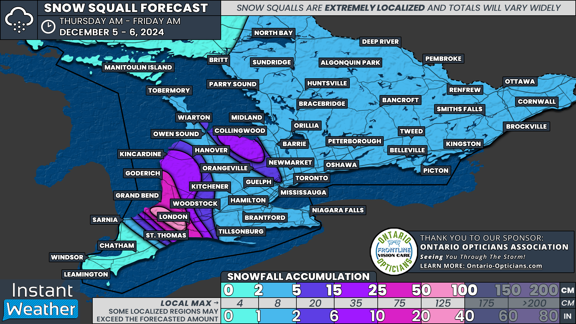
As the Alberta Clipper that brought widespread snowfall to Southern Ontario exits late Wednesday, snow squalls are set to return to the snowbelt regions. Unfortunately, the areas that were buried earlier this week will once again bear the brunt of this lake effect activity.

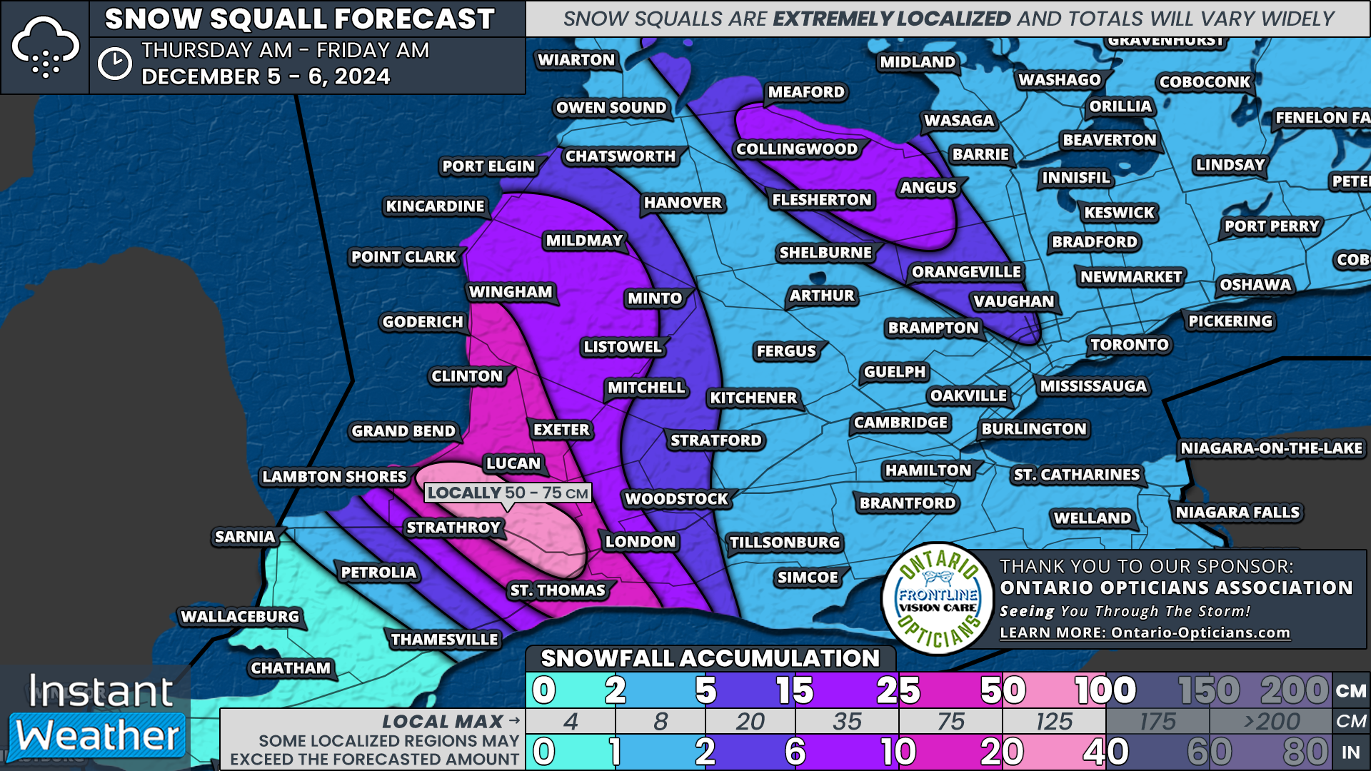
Locations just north and west of London appear to be in the bullseye, with the potential for 50 to 75 cm of fresh snowfall accumulation by the end of Thursday.


PRECIPITATION TYPE - MAP FROM WEATHERBELL

Lake effect activity is expected to begin organizing overnight and into early Thursday morning along the southern shorelines of Lake Huron and Georgian Bay. Current forecasts suggest this activity will consolidate into a few well-defined snow squalls by late morning or early afternoon.

The most intense squall is projected to form off the southeastern shoreline of Lake Huron, extending from Port Franks through Strathroy and into the west end of London. Additional streamers could impact areas further inland and along the eastern Lake Huron shoreline, stretching from Kincardine down to Grand Bend.


PRECIPITATION TYPE - MAP FROM WEATHERBELL

A separate squall will develop off Georgian Bay, spanning from Collingwood to Shelburne. Forecast models differ on the intensity of this squall, with some suggesting it could push far inland, potentially reaching parts of the Greater Toronto Area (GTA) just in time for the evening commute.

This scenario could bring a heavy burst of snow to the Hwy 400 corridor between Bradford and Vaughan, possibly extending to Mississauga and even the western parts of Toronto.


The primary concern with this event is that the squalls are unlikely to shift much throughout the day. Instead, they could remain stationary for over 12 hours, beginning Thursday morning and continuing into the late evening.

As seen in Muskoka over the weekend, stationary squalls can produce extreme snowfall rates of 10–15 cm per hour, quickly overwhelming plowing operations and making travel nearly impossible as highways are buried in snow.


Travel is strongly discouraged along the Lake Huron shoreline, particularly on Hwy 402 between London and Wyoming, during the day on Thursday and into the evening. Blizzard-like conditions, combined with rapid snowfall accumulation, will create dangerous and potentially life-threatening travel conditions.

The Georgian Bay squall is expected to diminish just after midnight, while the Lake Huron squall will gradually lift north of London during the pre-dawn hours on Friday. Additional lake effect snow is possible east of Lake Huron and Georgian Bay on Friday, though it remains unclear whether it will organize into significant squalls. We will provide updates in a separate forecast if substantial accumulation seems likely.


NOTE: YOU CAN CLICK ON THE MAP TO OPEN A ZOOMABLE IMAGE

The most intense snowfall is expected to target a small area west of London, including Parkhill, Ailsa Craig, and Strathroy, where totals could exceed 50 cm and potentially reach 75 cm. It’s important to note that these higher totals will be very localized, as the squall is forecast to be quite narrow. The exact location of the heaviest accumulation will depend on where the squall sets up.

While the City of London is likely to avoid the worst of the snowfall, it isn’t entirely in the clear. The city’s west end could see totals ranging from 25 to 50 cm. A slight eastward shift in the squall could place London directly in its path, significantly increasing snowfall totals for the area.

Lower amounts are expected in London’s east end, which is likely to see between 10 and 20 cm. St. Thomas could also be affected, with snowfall potentially reaching 20–30 cm depending on how far inland the squall extends.


Other communities along the southeastern shoreline of Lake Huron, including Grand Bend, Lucan, Exeter, Clinton, and Goderich, are projected to receive 25–50 cm by the time the squalls diminish on Friday morning.

As is typical with snow squalls, snowfall gradients will be extremely sharp, and accumulation will drop off quickly outside the most affected areas. Locations such as Kincardine, Listowel, and Mitchell can expect totals of around 10–20 cm.

The Georgian Bay squall is anticipated to be less intense than its Lake Huron counterpart. Accumulations of 15–25 cm are expected for areas like Collingwood and Shelburne. If the squall extends into parts of the GTA, it could bring a quick 5–10 cm of snow, primarily affecting Brampton, Mississauga, and other areas in the western GTA.

Less than 5cm is expected for the rest of Southern Ontario.

'Snow Day' Forecast: Yet Another Chance of School Bus Cancellations on Thursday in Southwestern Ontario

NOTE: YOU CAN CLICK ON THE MAP TO OPEN A ZOOMABLE IMAGE

Snow continues to linger across Southern Ontario as of Wednesday evening, but it is expected to taper off as the system exits the province overnight. However, snow squalls are forecast to develop along the southeastern shorelines of Lake Huron and Georgian Bay, potentially creating hazardous travel conditions.

Environment Canada has issued widespread snow squall warnings, which could prompt some school boards to keep buses off the roads for yet another day.


The highest probability of school bus cancellations is along the entire eastern shoreline of Lake Huron, including all regions within the Bluewater District School Board (BWDSB) and the Avon Maitland District School Board (AMDSB). This area is almost certain to experience a “snow day” on Thursday, with poor travel conditions making it difficult to see how buses could safely operate.

The Thames Valley District School Board (TVDSB), covering Middlesex, London, Oxford, and Elgin, also has a strong chance of cancellations, with probabilities ranging from 75% to 90%. The same applies to the Lambton zone of the Lambton Kent District School Board (LKDSB).


Around Georgian Bay, there is a 75% chance of cancellations for the “West” weather zone of Simcoe County, where snow squall activity is expected to be most intense. The “Central” and “North” weather zones have a 50% chance, as it is less certain whether conditions will be severe enough to lead to cancellations.

To the east of Georgian Bay, the snow is expected to taper off overnight, offering a bit of a reprieve. However, the Parry Sound region still has a 50% chance of cancellations due to the potential for blowing snow, which could create hazardous conditions. This school board also tends to be particularly cautious when it comes to weather-related disruptions.

For the Muskoka region, there is a slight chance of cancellations. If schools do reopen, Thursday would mark the first day back for much of Southern Muskoka since last Thursday.


For the rest of Southern Ontario, widespread cancellations are not anticipated. However, we have assigned a broad very low to low chance of cancellations across Eastern and Central Ontario, just in case blowing snow results in some unexpected disruptions.


Disclaimer: Instant Weather has zero authority when it comes to bus and school closures. It is completely up to the school boards, bus companies, local authorities, and parents to decide what is best for their children. This is our best guess based on our forecast.

Mix of Wet and Wintry Weather on the Way for the Maritimes, Bringing More than 20cm of Snow to Parts of New Brunswick

NOTE: YOU CAN CLICK ON THE MAP TO OPEN A ZOOMABLE IMAGE

More snow is on its way for New Brunswick and in a similar fashion to last week’s storm, Nova Scotia can once again expect mostly rain with the possibility of a bit of snow mixed in. The incoming system will be a mix of an Alberta clipper coming through Ontario and a secondary low from New England, and it will be another short blast of winter for the region, with the entire event spanning 24 hours.


Things will start off around midnight tonight as snow from the Clipper pushes its way into New Brunswick. As the snow spreads eastward across the province through the early morning hours, the low from the States will merge with the Clipper, which will funnel even more moisture northward from the Gulf. This secondary source of precipitation will reach Western Nova Scotia in the pre-dawn hours. The merging of these two systems will result in some intensification starting later in the morning, leading to heavier snow and rain across the region.

Nova Scotia

Nova Scotia will once again find itself in the warm sector of this storm, leading to precipitation falling mostly as rain for the duration of this event. However, there is a chance for some snow showers since temperatures will be hovering just above the freezing mark in some areas along the leading edge of the storm. Unfortunately for snow lovers, no real snow accumulation is expected from this storm, with temperatures climbing throughout the day and resulting in any snow transitioning to rain. The exception to this is, once again, in the higher elevations of Cape Breton where temperatures will remain below 0°C until Thursday evening, leading to 5-10cm of snow. Widespread rainfall totals across the rest of the province are expected to be in the 20-40mm range.

New Brunswick

On the other hand, New Brunswick can expect to need the shovels at some point on Thursday. The snow from the Clipper will push its way across the province throughout the early morning, but as the rain reaches Nova Scotia, it will also push into the Fundy Coast area, limiting snowfall accumulation along this stretch. Once the two systems merge and the storm intensifies, snowfall rates could approach 3cm per hour in the afternoon across Central and Northern New Brunswick, leading to widespread snow accumulations above 10cm. In the early and mid-afternoon, warm air will wrap around the backside of the storm, resulting in a transition from snow to rain that will push northeastward into the evening. Temperatures will fall overnight, but the warm air, along with the rain, will result in the melting of some of the fresh snow across most of the province.

Prince Edward Island

The leading edge of the precipitation will reach Prince Edward Island around noon on Thursday, with some light snow that will last for several hours. This will bring up to 5cm of snow across the Island before the warm air moves in and the snow switches over to rain. Similar to New Brunswick, the warm air and rain will melt most, if not all, of the freshly fallen snow across the province throughout the evening.

The storm will start to dissipate in the early afternoon, with the arrival of the warm air in New Brunswick and it will fully exit the region shortly midnight and into Friday morning. There could still be some lingering flurries or pockets of light rain throughout early Friday morning.

'Snow Day' Forecast: Heavy Snow on Wednesday May Cancel Some School Buses in Southern Ontario

NOTE: YOU CAN CLICK ON THE MAP TO OPEN A ZOOMABLE IMAGE

An Alberta Clipper is set to move into Southern Ontario early Wednesday, bringing the potential for 20-30 cm of snow in some areas. Snow squalls will also persist northeast of Georgian Bay, as well as near Lakes Erie and Ontario, during the morning hours.

The anticipated impact on Wednesday morning’s commute, combined with potential disruptions to the afternoon commute, will likely lead some school boards to cancel school buses. While there is still some uncertainty about how widespread these cancellations will be, certain areas have a higher probability of being affected.


There is a 90% chance of a “snow day” for the Bruce Peninsula and areas northeast of Georgian Bay. This includes the entire Near North District School Board (NNDSB), which is known to be highly cautious regarding weather conditions. The expected snow squalls in these areas are likely to meet the criteria for bus cancellations.

For the rest of Central Ontario, parts of Eastern Ontario, and rural areas of Southwestern Ontario, the probability of school bus cancellations ranges from 50% to 75%. Confidence is slightly lower in these regions because much of the snow is expected to fall after morning cancellation decisions are made. Additionally, Environment Canada has gone with winter travel advisories, which may not carry enough weight for some school boards to cancel buses proactively.


The likelihood of cancellations increases in areas forecasted to experience snow squalls or where blowing snow advisories are in effect. This includes regions along the shorelines of Lakes Huron, Ontario, and Erie, where reduced visibility and challenging travel conditions are expected.

In contrast, urban school boards in the Greater Toronto Area (GTA) are unlikely to cancel buses, as the forecasted conditions are not expected to meet the higher thresholds typically required for urban cancellations. We’ve assigned a slim 5-10% chance to account for the possibility of an unexpected decision by one of the boards, but this remains highly improbable.


Similarly, Deep Southwestern Ontario—including Sarnia, Windsor, and Chatham—is unlikely to see school bus cancellations, as these areas are forecasted to receive less than 5 cm of snow from this system. Conditions there are not expected to be severe enough to warrant disruptions.


Disclaimer: Instant Weather has zero authority when it comes to bus and school closures. It is completely up to the school boards, bus companies, local authorities, and parents to decide what is best for their children. This is our best guess based on our forecast.

Alberta Clipper to Bring a Snowy Blast to Southern Ontario on Wednesday With Up to 20cm Possible; Snowbelt Region Could See Up to 50cm

NOTE: YOU CAN CLICK ON THE MAP TO OPEN A ZOOMABLE IMAGE

The snowy landscape across Southern Ontario is quickly transforming as a multi-day snow squall event has blanketed parts of the snowbelt regions with over 100 cm of snow.

While the intense accumulation has primarily impacted areas around Lake Huron and Georgian Bay, the rest of Southern Ontario will soon have their turn as a weather system moves into the region on Wednesday.


This system-related snowfall will likely combine with lake enhancement and embedded snow squalls, resulting in higher accumulations in the snowbelt areas that are still digging out from the weekend’s relentless snowfall.

By Thursday morning, some snowbelt regions could see an additional 30-50 cm of snow. Meanwhile, a general 5-15 cm of snow is expected across much of Southern Ontario, including parts of the Greater Toronto Area (GTA), which has experienced minimal snowfall so far this season.

The Alberta clipper responsible for this system began pushing into Northwestern Ontario from Manitoba on Tuesday afternoon. Moderate to heavy snow will continue spreading across Northern Ontario through the evening and overnight.


NOTE: YOU CAN CLICK ON THE MAP TO OPEN A ZOOMABLE IMAGE

In Northern Ontario, we expected the highest snowfall totals to be found east of Lake Superior stretching from Wawa down to Sault Ste. Marie. Snowfall totals of between 30 to 50cm are possible thanks to the system-related snowfall and snow squalls off Lake Superior.

Other areas around the Georgian Bay shoreline extending into Sudbury could be looking at around 20cm of snowfall accumulation. This will also be the case south of Lake Nipigon which could see some lake enhancement between Thunder Bay and Geardton.

The rest of Northeastern Ontario is looking at around 10 to 15cm with locally up to 20cm. Less than 10cm is expected for Northwestern Ontario including Thunder Bay.


PRECIPITATION TYPE - MAP FROM WEATHERBELL

Ahead of the system, lake effect snow has already started to intensify, beginning with Lake Superior on Tuesday afternoon. By Tuesday evening, snow squalls are expected to organize off Lake Huron and Georgian Bay, primarily targeting the Bruce Peninsula and areas northeast of Georgian Bay, such as Parry Sound, Britt, and North Bay. These snow squalls are likely to persist through the night into Wednesday morning.

Additional lake effect snow could develop off Lake Erie and Lake Ontario during the early morning hours of Wednesday, potentially drifting into the southern Niagara region and Prince Edward County. While this activity may cause reduced visibility and locally heavy snowfall, the squalls are not expected to remain stationary for long, limiting overall accumulation.


PRECIPITATION TYPE - MAP FROM WEATHERBELL

As the system reaches Southern Ontario around sunrise on Wednesday, the existing lake effect snow bands are expected to merge with the system’s light to moderate snowfall. This merging could enhance snow totals, particularly off the northern shorelines of Lake Erie and Lake Ontario. Narrow bands of heavy snow could stretch across the Niagara region and into parts of Central and Eastern Ontario, leading to significant variations in snowfall accumulations.

Snow totals will likely vary substantially due to localized banding caused by lake enhancement. Some areas may see only 5 cm, while nearby locations could receive 15-20 cm, depending on where the snow bands develop.


Another key factor with this system will be strong wind gusts, ranging from 50-70 km/h across Southern Ontario, beginning Wednesday morning and continuing throughout the day. These winds, combined with steady snowfall, could create blowing snow and reduced visibility, making travel hazardous. With this being the first significant snowfall event of the season outside the snowbelt, drivers are urged to exercise caution.

PRECIPITATION TYPE - MAP FROM WEATHERBELL

While the system is expected to exit Southern Ontario by late Wednesday, snow squall activity will persist off Lake Huron and Georgian Bay. An intense squall is projected to develop off Georgian Bay late Wednesday evening, stretching inland toward Midland, Orillia, and Gravenhurst, and continuing into the early hours of Thursday.


PRECIPITATION TYPE - MAP FROM WEATHERBELL

By Thursday morning, shifting winds will push the Georgian Bay squall southward toward Collingwood and Angus. This squall may extend far inland at times, impacting the Highway 400 corridor between Vaughan and Barrie, as well as parts of the northern GTA. Meanwhile, a Lake Huron squall is anticipated to stretch from Goderich through Grand Bend and into the London area.

Significant snowfall could occur on Thursday if these squalls remain stationary for an extended period. Current models suggest they may not weaken until late Thursday night or early Friday morning, potentially producing intense snowfall rates for over 24 hours.


NOTE: YOU CAN CLICK ON THE MAP TO OPEN A ZOOMABLE IMAGE

Regarding snowfall totals, the uneven distribution caused by lake enhancement means localized accumulations will vary widely. The highest confidence lies in regions northeast of Georgian Bay, including Parry Sound, Sundridge, Britt, and North Bay, where 30-50 cm of snow is expected, with localized amounts possibly exceeding those totals due to snow squalls.

Surrounding areas, such as Muskoka and Orillia, could see 20-30 cm of snow by Thursday morning, accounting for system snow, lake enhancement, and snow squall activity. Similarly, areas east of Lake Huron could see totals ranging from 20-30 cm.


In Central and Eastern Ontario, widespread snowfall is likely to range from 10-15 cm, except for the Ottawa Valley, where accumulations may be closer to 5 cm. Lake enhancement could push some areas along the northern shorelines of Lake Ontario and Prince Edward County closer to 20 cm.

For regions such as Kitchener, Woodstock, Guelph, and Barrie, snowfall totals are projected to reach 10-15 cm. However, variability due to lake enhancement may result in some areas seeing lower amounts. The GTA is expected to receive closer to 5 cm, while the Niagara region could accumulate 5-10 cm, with localized heavier bands of snow influenced by Lake Erie.


In Deep Southwestern Ontario, snowfall amounts will decrease westward, with London forecasted to receive around 10 cm. Further southwest, including Sarnia, Windsor, and Chatham, totals are expected to remain under 5 cm.

It’s important to note that these totals do not account for the snow squalls expected to impact areas southeast of Lake Huron and Georgian Bay beginning Thursday morning. High-resolution models are still refining the locations of these squalls, but additional accumulations of 30-50 cm are possible in affected areas. Stay tuned for a detailed update in a separate forecast.


Steep Drop in Temperatures Will Lead to Flash Freeze Risk This Evening and Freezing Rain Into Wednesday

NOTE: YOU CAN CLICK ON THE MAP TO OPEN A ZOOMABLE IMAGE

It’s been a bit of a weather roller coaster across Southern and Central Alberta over the past several days, with snow and frigid Arctic air late last week to single digit temperatures, melting snow and even some rain falling in the Northern Rockies.

Now, temperatures are expected to plummet later this evening, leading to a risk for a flash freeze along with freezing rain across a swath of the province continuing throughout the day tomorrow.


Warm temperatures across Central and Southern Alberta in the single digits have resulted in the melting of some of the existing snowpack. On top of this, precipitation has already begun to push into the Northern Rockies region of Alberta from British Columbia as a mix of rain and snow this afternoon.

As the precipitation pushes deeper into the province and temperatures quickly fall to just below the freezing mark this evening, not only will the melted snow and slush rapidly freeze, the rain will also transition over to freezing rain, creating very icy conditions. This patch of freezing rain will remain fairly stationary around Grande Prairie into Wednesday morning, leading to ice accretions up to 5mm. At this point, the entire system will begin to push southeastward across the province, bringing light freezing rain along a narrow track throughout the day, adding to the already icy conditions expected from the flash freeze.

To the north of this freezing rain, where temperatures will be slightly cooler, light snow is expected to fall. Snowfall accumulations will also be limited with this system and a widespread 5-10cm is expected.

'A Conveyor Belt of Snow’; How Lake Effect Snow Can Bury Entire Towns in a Matter of Days

satellite image of lake effect snow over the Great Lakes, courtesy of the national weather service.

Following the incredible snowfall seen in Sault Ste. Marie and across parts of Muskoka over the weekend, we figured this would be the perfect opportunity to discuss lake effect snow. It’s something that many of us in Ontario have come to expect in the late fall and early winter, especially since we’re surrounded by the Great Lakes.


Certain ingredients are required for lake effect snow to occur, but most importantly, there needs to be an unfrozen body of water and a very cold air mass from the Arctic.

In order for lake effect snow to even start to form, there needs to be a temperature difference of at least 13°C between the warm surface of the lake and the 850mb pressure level of the atmosphere (this is typically found at around 1500 metres). The greater the temperature difference, the more unstable the atmosphere becomes and this is often when we see strong convection and the phenomenon known as thundersnow. Without this difference in temperature, lake effect snow simply can not occur. Once this threshold is reached, however, it’s like a switch being flipped and the lake effect snow machine starts.

Another key component in lake effect snow development is moisture. Ideally, the relative humidity at the surface needs to be at least 80% for lake effect snow to form and levels below 70% could actually inhibit development. It can usually be assumed that the lake itself can provide enough moisture, but this is not always true. There also needs to be limited wind shear with height between the surface and the 700mb pressure level so that the moisture is more focused, sort of like a hose. The strongest, most organized bands of lake effect snow develop when the wind shear is less than 30°.

Finally is the concept known as “fetch”. Yes, millennials, we’re trying to make fetch happen. Fetch is the distance that the air mass travels over the lake. Fetch needs to be at least 100km in order for lake effect snow to develop and the greater the fetch, the more snow is produced. When considering prevailing wind directions, the traditional snowbelts are found in areas that are downwind of the greatest possible fetch over the Great Lakes, i.e. Buffalo and the entire length of Lake Erie.


The creation of lake Effect Snow. Courtesy of Environment Canada.

When all of these conditions are met, we can see how lake effect snow actually develops.

As the cold air mass travels over the much warmer surface of the lake, the warmth and moisture from the surface is transferred into the lower atmosphere. The warmer, moister air rises and it eventually cools and condenses, forming narrow bands of clouds. These clouds continue to travel over the open lake, gathering even more moisture, until they eventually reach land and the snow starts to fall at rates that can easily exceed 5cm per hour and could even be as high as 20cm per hour! It’s important to note that the hardest hit areas are actually not found immediately at the shoreline, but rather 30-50km inland from the lake.

The direction of the winds dictates which areas are hit by the lake effect snow so as long as the ideal conditions continue, so too will the development and subsequent falling of lake effect snow. This could lead to several days of heavy snow hitting the same area while there are sunny skies less than 20km away. A slight shift in wind direction can quickly change which area gets hit and that makes lake effect snow notoriously tough to forecast.

'Snow Day' Forecast: Tuesday Is Likely to Bring Another Round of School Bus Cancellations in Southwestern Ontario

NOTE: YOU CAN CLICK ON THE MAP TO OPEN A ZOOMABLE IMAGE

The seemingly endless potential for snow squalls is set to persist through Monday evening and into Tuesday morning. This round will primarily affect the eastern and southern shorelines of Lake Huron, where an additional 10 to 25 cm of snow is expected overnight. These conditions will likely lead to more school bus cancellations in areas already impacted on Monday.


.Meanwhile, the cleanup continues in the Muskoka region following the intense snow squalls that dumped over 100 cm of snow on Bracebridge and Gravenhurst over the weekend. The Trillium Lakelands District School Board has announced that ONLY schools in Gravenhurst will remain closed on Tuesday, while buses serving the Bracebridge area will not be running.

Schools and transportation services in Huntsville will operate as usual. We’ve marked this region as "Already Cancelled" on our map, as the school board rarely issues sub-regional cancellations. For precise details, check the official announcement linked here.


For weather-related cancellations elsewhere, the strongest likelihood of a "snow day" is in AMDSB (Exeter), with a 90% probability due to expected intense snowfall accumulation overnight.

Surrounding areas, including BWDSB (Southampton and Kincardine), AMDSB (Goderich and Stratford), TVDSB (Middlesex and London), and LKDSB (Lambton), have a 50/50 to strong chance of school bus cancellations, as these regions could see notable snowfall and challenging travel conditions.


There’s also a 50/50 chance of cancellations in BWDSB (Meaford) and the "West" weather zone of Simcoe County due to potential snow squall activity off Georgian Bay. However, there is less confidence in whether the snowfall will be intense enough to disrupt transportation.

For the rest of Southern Ontario, school bus cancellations on Tuesday are unlikely. That said, attention is already shifting to Wednesday, as a developing weather system could bring widespread snowfall accumulation, with the potential to significantly impact some areas.

This may lead to school bus cancellations midweek. Stay tuned for our ‘snow day’ forecast on Tuesday afternoon!


Disclaimer: Instant Weather has zero authority when it comes to bus and school closures. It is completely up to the school boards, bus companies, local authorities, and parents to decide what is best for their children. This is our best guess based on our forecast.

'Snow Day' Forecast: Widespread School Bus Cancellations Likely on Monday Around Lake Huron and Georgian Bay

NOTE: YOU CAN CLICK ON THE MAP TO OPEN A ZOOMABLE IMAGE

Intense snow squalls continue to pound the snowbelt regions surrounding Lake Huron and Georgian Bay, persisting through the weekend and expected to last into Monday. Environment Canada has issued widespread snow squall warnings, forecasting an additional 30 to 50 cm of snow by Tuesday.

Given these conditions, it seems highly likely that many school boards in the hardest-hit areas will cancel buses on Monday morning. Travel will remain hazardous throughout the day, making it nearly impossible to operate school buses safely.


The highest confidence for cancellations lies along the Eastern Lake Huron and Southern Georgian Bay shorelines, affecting boards like AMDSB (Goderich and Exeter) and BWDSB (Kincardine and Meaford). In these regions, there is a 90% chance of a "snow day" on Monday.

For Trillium (Muskoka), there’s also a 90% likelihood of cancellations. While no significant additional snowfall is expected overnight, the extensive cleanup from previous snowfalls and the continued closure of the major highway in the region will likely make bus travel unfeasible.

UPDATE (6:15 PM): Trillium Lakelands DSB has announced that schools in the Muskoka region will be closed on Monday.

Similarly, NNDSB (Parry Sound) and Trillium (Haliburton) face potential cancellations, but with lower probabilities of 50% and 25%, respectively, as these areas were not as severely impacted.


Surrounding areas, including TVDSB (Middlesex), AMDSB (Stratford and Listowel), BWDSB (Southampton, Owen Sound, and Hanover), and the "West" weather zone for Simcoe County, have a 75% chance of seeing buses canceled due to lingering squall activity and ongoing poor travel conditions.

Outside the core snowbelt regions, the likelihood of cancellations decreases significantly. For the "North" and "Central" weather zones in Simcoe County, there’s a 50/50 chance of a snow day. While the brunt of the lake-effect snow is expected to remain closer to Georgian Bay, Environment Canada’s snow squall warnings could still prompt precautionary cancellations.


The chances are also 50/50 in London and Oxford County, where snow squall activity is less certain to intensify enough to justify cancellations. Urban boards like these often have higher thresholds for cancellations compared to rural regions.

For the remainder of Southern Ontario, school bus cancellations are unlikely, as the worst conditions are expected to remain confined to the typical snowbelt areas.


Disclaimer: Instant Weather has zero authority when it comes to bus and school closures. It is completely up to the school boards, bus companies, local authorities, and parents to decide what is best for their children. This is our best guess based on our forecast.

Snow Squalls Continue to Paralyze Ontario’s Snowbelt With Another 25-50cm of Snow by Monday

NOTE: YOU CAN CLICK ON THE MAP TO OPEN A ZOOMABLE IMAGE

It may have been a slow start to the winter season across Southern Ontario, but November is certainly ending with a bang. Above-average lake temperatures have fueled intense lake-effect snow squalls that have pummeled the snowbelt regions over the past few days.


As of Saturday evening, some of the hardest-hit areas, including Bracebridge, Gravenhurst, and Hanover, have reported snowfall totals ranging from 50 to 100 cm, with localized pockets even exceeding the 100 cm mark! This has led to massive issues on the roads as dozens of drivers were left stranded on Hwy 11 south of Gravenhurst due to extreme snowfall accumulation.

But the snowy barrage is far from over for these regions. By the time the squalls wind down late Monday, an additional 25 to 50 cm of snow could accumulate around areas east of Lake Huron and Georgian Bay.


Currently, intense snow squall activity is ongoing east of both lakes, with a focus on the Bala-to-Bracebridge corridor and the Tiverton-to-Walkerton stretch. These squalls are expected to remain mostly stationary overnight, with snowfall rates reaching 5 to 10 cm per hour. This could add another 25 to 50 cm of snow in already heavily affected areas by Sunday morning.

By Sunday morning, a shift in wind direction is anticipated, pushing the squalls further south. The Georgian Bay squall will likely bring a quick but intense blast of snow to Midland, Orillia, and Barrie. Meanwhile, the squall near Hanover is expected to dissipate by late morning, only to be replaced by a more robust squall moving in from the north, targeting Owen Sound and Kincardine.


PRECIPITATION TYPE - MAP FROM WEATHERBELL

This northern squall could stretch far enough inland to reach areas like Orangeville and perhaps even the Greater Toronto Area (GTA) by mid-afternoon. Although it won't last long enough to produce significant accumulation, it could lead to a sudden reduction in visibility and a quick 2 to 5 cm of snow. Similarly, Kitchener and Guelph may experience a few hours of heavy snow as the squall moves through.


PRECIPITATION TYPE - MAP FROM WEATHERBELL

By Sunday evening, the squalls are expected to settle southeast of Georgian Bay and Lake Huron. Collingwood and Meaford are likely to find themselves in the crosshairs of the Georgian Bay squall, while the Lake Huron squall will stretch from Goderich along the shoreline to Grand Bend and inland towards areas north of London.

According to the latest model data, the Georgian Bay squall may remain closer to the shoreline, potentially sparing Barrie and the Hwy 400 corridor from the heaviest snow.


However, London might not be as fortunate. The Lake Huron squall could extend into the city at times during the overnight hours and into early Monday. That said, the most intense snowfall rates are expected to stay north of London, impacting areas like Exeter, St. Marys, and Stratford.

Snow squall activity will persist throughout Monday and possibly into the overnight hours before tapering off late Tuesday morning. This will coincide with the arrival of a system from the west that could bring more widespread snowfall to parts of Southern Ontario. Details on that system will be shared in a separate forecast.


As is typical with snow squalls, snowfall totals will vary significantly depending on where the squalls settle. There is high confidence that regions in Muskoka and along much of the eastern Lake Huron shoreline will see an additional 25 to 50 cm of snow on top of what has already fallen.

Northwest of London, models indicate the Lake Huron squall could stall over the area from Sunday evening through Tuesday morning, potentially leading to localized totals exceeding 50 cm. Confidence in this scenario remains low, so we’ve held off from including it in our snowfall map for now.

The City of London is forecast to receive 15 to 25 cm of snow from the southern tip of the Lake Huron squall. However, there is potential for slightly higher totals depending on how far the squall extends inland.


The southern shoreline of Georgian Bay, including Collingwood and Meaford, is expected to see 25 to 50 cm of snow, with higher amounts likely in elevated areas such as Blue Mountain—great news for ski enthusiasts!

Simcoe County, including Barrie and Orillia, is forecast to receive lesser amounts, with 5 to 15 cm (possibly up to 20 cm) expected during the morning and afternoon hours on Sunday. Kitchener and Woodstock could also see 5 to 10 cm of snow from the Lake Huron squall.

Outside these core regions, snowfall will be minimal, with most areas receiving less than 5 cm. We are keeping an eye on the southern Niagara region and Prince Edward County, which could potentially be grazed by snow squall activity that is currently expected to remain south of the border. If it does drift north, localized totals of 5 to 10 cm could develop in areas like Fort Erie, Port Colborne, and Picton.

Another Night of Extreme Cold on Tap, Warnings Extend into Manitoba for Tonight as Windchills Reach -40°C Over a Wider Area

NOTE: YOU CAN CLICK ON THE MAP TO OPEN A ZOOMABLE IMAGE

The extreme cold continues across the Prairies with overnight lows dipping below -20°C across a large part of the region and lower than -30°C in Central Saskatchewan once again tonight and into tomorrow morning.

This intense cold poses a risk to everyone, especially young children, the elderly, individuals with chronic illnesses, outdoor workers, and those without adequate shelter. Symptoms of cold exposure, such as shortness of breath, chest pain, muscle pain and weakness, numbness, and colour change in fingers and toes, should be monitored closely.

Winds overnight tonight are expected to remain similar to last night, peaking at around 10-15km/h, but they are expected to be more widespread. These light winds will easily push the windchill below -40°C over a larger area, resulting in Environment Canada issuing more Extreme Cold Warnings for tonight.

At these temperatures, frostbite can occur in as little as 30 minutes so it is crucial to cover up when going out and limiting exposure all together. It’s also wise to keep emergency supplies in your vehicle, including extra blankets and jumper cables, in case of an emergency.

It appears that Saskatchewan and Manitoba could see a bit of a reprieve tomorrow night, with the coldest air expected to be found in Alberta instead.


UPDATE: Squalls on Track to Bury Parts of Ontario’s Snowbelt in Up to 100cm of Snow by Saturday

NOTE: YOU CAN CLICK ON THE MAP TO OPEN A ZOOMABLE IMAGE

Confidence remains high for a very impactful snow squall event, which began east of Georgian Bay and Lake Huron Thursday evening. By the end of Saturday, some parts of the snowbelt region could be digging out of up to 50 to 100cm of snow!

Intense snow squall activity is expected to persist throughout Friday, with two primary squalls forming off Georgian Bay. The southern squall looks to settle between Honey Harbour and MacTier, extending inland toward the Highway 11 corridor from Washago to Bracebridge. This squall may reach as far inland as Haliburton and potentially Bancroft at times.


The second squall is projected to stretch across the northern tip of the Bruce Peninsula, coming onshore near Parry Sound. Unlike the southern squall, this one may not push as far inland, meaning Huntsville could see lighter impacts compared to areas like Bracebridge and Gravenhurst.

Snow squalls will also persist east of Lake Huron, with the most significant activity setting up just south of Hanover. Higher totals inland can be attributed to colder temperatures in elevated areas, where snow will accumulate more efficiently, compared to the slightly above-freezing conditions closer to the shoreline.


As Friday progresses, models suggest a brief wind shift by the evening, potentially driving the Georgian Bay squall south of Muskoka and into parts of northern Simcoe County.

There is some uncertainty about how far south this squall will drift, but most models suggest it will impact Midland, areas just north of Orillia, and into Rama. Within Orillia, accumulation could vary significantly, with lower totals in the south and much higher amounts in the north, reflecting the sharp gradient shown on our map.


By Saturday morning, the squall is expected to shift back north, realigning across the Parry Sound and Muskoka region. However, this time, it may consolidate into a singular band stretching from Parry Sound into northern Muskoka. This could spare Gravenhurst and Bracebridge from heavy snowfall on a second day, while Huntsville might see more snow as the squall locks into place for much of Saturday.

IMPORTANT

To provide the most accurate information, we are now breaking the snowfall totals into two separate forecasts. This forecast covers Friday and Saturday, while a second forecast will address Sunday and Monday and will be released on Saturday.


Our earlier forecast covered the entire four-day period and was intentionally broad to account for a wide range of possibilities. If the snowfall totals for your area are lower than what we initially predicted, it’s likely because your snow will fall later on Sunday or Monday.

As we’ve emphasized in previous updates, snow squalls are notoriously difficult to predict, with sharp gradients between areas of light snow and those with extreme accumulations.


In terms of snowfall totals, localized amounts are likely to exceed 50 cm and may even approach 100 cm by the end of Saturday in areas like Parry Sound, Bracebridge, and Gravenhurst. Similar totals are possible for Tobermory and Hanover.

Owen Sound and Collingwood could also experience heavy snow from a Lake Huron streamer, with higher elevations aiding accumulation. These areas could see snowfall ranging from 25 to 50 cm in the most affected zones.


Given the tight gradients, snowfall totals will decrease quickly as you move away from the primary snow squalls. Expect 15 to 30 cm across much of Grey-Bruce counties, northern Simcoe County, northern Kawartha Lakes, and Haliburton (excluding the heaviest-hit areas mentioned earlier).

For the rest of Southern Ontario, less than 5 cm is expected by the end of Saturday. However, regions like Barrie, Kitchener-Waterloo, and London could see some snowfall accumulation on Sunday and Monday as the winds shift late Saturday. So, if you’re hoping for snow in those areas, don’t give up yet!

Stay tuned for more updates, including our next detailed forecast on Saturday!

First Extreme Cold Air of the Season to Settle Across the Prairies Over the Coming Days, Overnight Lows Dipping Below -30°C

NOTE: YOU CAN CLICK ON THE MAP TO OPEN A ZOOMABLE IMAGE

While it has been quite cool across the Prairies this week on the backside of last weekend’s storm, it’s about to get even colder over the next few days. The first of this extreme cold will be experienced overnight Thursday and Friday morning. A large swath of the Prairies will have overnight lows below -20°C tonight while parts of Central Saskatchewan will see temperatures dipping below -30°C, prompting the first Extreme Cold Warnings of the season from Environment Canada that includes Saskatoon.

This intense cold poses a risk to everyone, especially young children, the elderly, individuals with chronic illnesses, outdoor workers, and those without adequate shelter. Symptoms of cold exposure, such as shortness of breath, chest pain, muscle pain and weakness, numbness, and colour change in fingers and toes, should be monitored closely.

Winds overnight are expected to top out at around 10-15km/h and while this is just a light breeze, it’ll be enough to drive the windchill well below -40°C in the coldest areas. At these temperatures, frostbite can occur in as little as 30 minutes so it is crucial to cover up when going out and limiting exposure all together. It’s also wise to keep emergency supplies in your vehicle, including extra blankets and jumper cables, in case of an emergency.

We will continue to provide updates over the coming days as these cold temperatures persist.


'Snow Day' Forecast: Snow Squalls Likely to Cancel School Buses on Friday in Parts of Central and Southwestern Ontario

NOTE: YOU CAN CLICK ON THE MAP TO OPEN A ZOOMABLE IMAGE

A multi-day snow squall event is set to begin Thursday evening, targeting regions east of Lake Huron and Georgian Bay. Intense snowfall rates exceeding 5 cm per hour, coupled with near-zero visibility, are expected to make travel nearly impossible throughout Friday and well into the weekend.

Environment Canada has already issued strongly worded snow squall warnings for the Parry Sound, Muskoka, and Grey-Bruce regions. These warnings highlight the potential for road closures due to hazardous conditions.


Based on these forecasts, it’s highly likely that school boards in the affected areas will cancel school buses on Friday. In fact, given the severity of the conditions, some school closures may also occur.

Areas Most Likely to See Bus Cancellations
The following school boards are almost guaranteed to experience a “snow day” on Friday: TLDSB (Muskoka), NNDSB (Parry Sound), and BWDSB (Bruce Peninsula). This prediction aligns with the areas currently under snow squall warnings and the forecasted weather conditions during Friday morning’s decision-making window.

There is also a strong 75% chance of school bus cancellations for Southampton and Kincardine, part of BWDSB, as well as for East Parry Sound under NNDSB.


Outside of these core areas, the likelihood of school bus cancellations decreases significantly. We estimate a 50% chance for the following areas: TLDSB (Haliburton), Simcoe County (North Weather Zone), and the inland portions of BWDSB, which include Hanover, Owen Sound, and Meaford.

A similar probability applies to RDSB (Manitoulin Island), where snow squall warnings are in effect. However, the rest of RDSB, including Sudbury, is unlikely to see cancellations as the main squall activity is not expected to reach those areas.


For surrounding school boards across Central Ontario and parts of Southwestern Ontario, the chances of school bus cancellations are slim, ranging between 5% and 25%.

While most of the impacts will remain concentrated in the snowbelt regions, there’s always a small possibility of localized cancellations depending on shifting conditions.


Disclaimer: Instant Weather has zero authority when it comes to bus and school closures. It is completely up to the school boards, bus companies, local authorities, and parents to decide what is best for their children. This is our best guess based on our forecast.

First Taste of Winter With Up to 30cm of Snow for Parts of the Maritimes, More Rain in Nova Scotia

NOTE: YOU CAN CLICK ON THE MAP TO OPEN A ZOOMABLE IMAGE

As November comes to an end, the first winter storm of the season is headed for the Maritimes. Over the past few days, we’ve been monitoring the development of a potent winter storm in the U.S. that’s expected to track into the region through New England on Thursday.

Until Wednesday morning, there had been considerable disagreement between weather models regarding the exact track of the storm through the Maritimes and where the heaviest snow would fall. As the event has gotten closer, these models have started to come into agreement and now we have a clearer picture of what is on its way.


Precipitation will push into Southern New Brunswick starting Thursday afternoon. As the storm makes its way into the region, the precipitation will start off as rain in both New Brunswick and Nova Scotia before the snow starts to make its way into New Brunswick and eventually crosses into Cumberland County, Nova Scotia and Prince Edward Island. This means that most of the Maritimes can expect to receive a few hours of rain before the arrival of any snow. This storm will have a warm sector along its southern side, with temperatures remaining in the single digits, resulting in precipitation falling as rain across most of Nova Scotia for the duration of the event.

Both the rain and snow will start to intensify later in the evening, at which time the edge of the storm will reach PEI. Snowfall rates of up to 5cm/hr are likely at times in Central and Northeast New Brunswick overnight and into Friday morning, leading over 20cm of snow accumulation in a span of 12 hours.

In Nova Scotia, on the other hand, widespread rainfall amounts of 10-30mm are expected, adding to what has already been a very wet month for parts of the province. The Annapolis Valley and the Northhumberland Shore could see a brief transition from rain to light snow overnight with temperatures approaching the freezing mark, but little to no accumulation is expected. Meanwhile, the air in the higher elevations of the Cape Breton Highlands will be cool enough for snow to fall for the duration of the storm and the area can expect 5-10cm.

In Prince Edward Island, the heavy snowfall will cross into Prince County shortly after midnight, which will lead to higher snowfall totals in that part of the Island. We’re expecting to see some warmer air getting wrapped into the backside of the storm in the early morning hours of Friday, leading to a transition from rain to snow across Southern New Brunswick and into Cumberland County and PEI and limiting the snowfall totals in these areas as the storm continues to track through the Maritimes.

The rain is expected to start to taper off in Western Nova Scotia in these early morning hours, gradually ending across the province through the morning. The rest of the storm will then begin to exit the region just before sunrise with the precipitation eventually ending by mid-afternoon in Northeast New Brunswick.